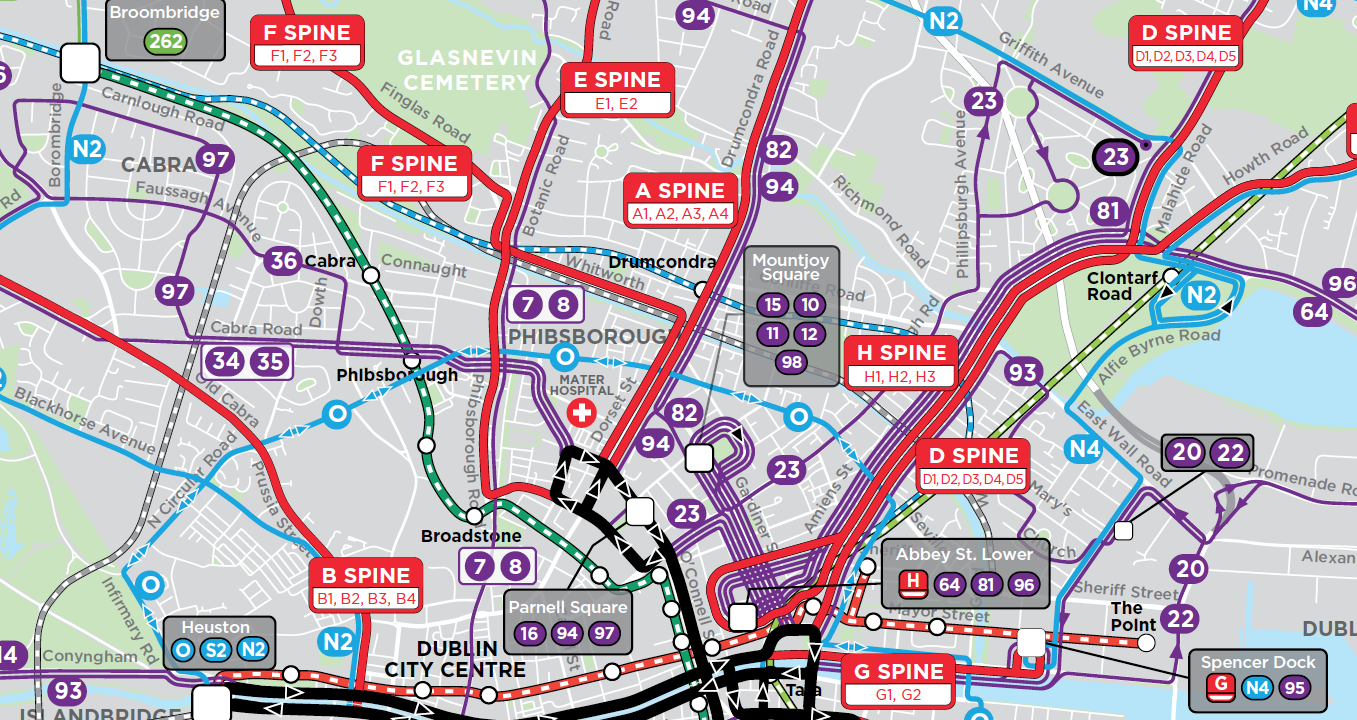
Map: National Transport Authority of Ireland
After many months of thinking about the feedback we got on our draft, a new version of the bus network plan for Dublin is out today! At this site you’ll find:
- Links to our revised report, and to the report on the consultation process, at the bottom of the cover page.
- A map of the revised network. (Detail about frequency is no longer on the website’s map but is in the maps and frequency tables in Chapter 7 of the report.)
- Local area maps with more detail. We understand that the National Transport Authority will be sending these maps to every household in Dublin.
- A helpful tool that shows how any trip you select would be completed in the new network.
- A little video explaining how a spine works. (Here’s a written explanation.)
- A way to provide feedback or ask questions.
You may recall that the last draft received a lively and sometimes hostile response. That’s the whole point of drafts: as a starting point for conversation. The new network plan won’t resolve every complaint, but it shows NTA’s best effort (with our advice) to reflect what we heard, and to integrate those comments into a functional and efficient network.
The heart of the network design, the frequent grid of spines and orbitals, is unchanged, but many services have been added or revised.
We are at the end of our engagement with NTA, so we won’t be as engaged in Twitter discussions about the details as we were in the last round. But we will be watching this project closely.
Many thanks Jarrett!, from a Dublin bus user…
“(Here’s a written explanation.)”
Links to an .mp4 file which is very unlikely to be written.
Thanks Jarrett and the team. All feedback in Dublin tends to be somewhat “lively” but your efforts are much appreciated by most bus users in the city.
Why have you abandoned frequency coloring from the latest version of the new Dublin bus map? Very bad change. You have advocated many times for coloring by frequency, and not by the direction of the route. So why this sudden turn of direction? Orbital, city-bound, local etc routes should not have different colors. Colors should denote frequency and nothing else. Please return to your previous approach for all your future maps.
That’s actually not JWA’s map, though it is sourced from material developed by JWA. NTA made the decision to show routes by type rather than frequency in the public-facing (brochure) maps. I can’t speak for them, but my guess is that they wanted it to be 100% clear on the maps which routes would go to City Centre and which wouldn’t. If you download the report you’ll still find maps coded by frequency, which is JWA’s preferred style. Chapter 7 has the full maps, existing and proposed.
This plan looks good, and does not pit ridership and coverage against each other.
This may be the first plan I have seen from your team that actually provides an enhanced system without telling certain areas of the region they are not worthy of transit.
Good work!
Every single plan, by definition, must pit ridership and coverage against eachother. What you are actually saying is that *you* like the compromise that has been struck.
A small curiosity: did the team doing the redesign do consultation or receive any feedback in Irish (Gaeilge)?
Many thanks for your efforts, the initial reaction saddened me and as much as I tried to sell the benefits to people in my neighbourhood it fell on deaf ears. The first draft would have been a lot more useful for me personally, but at least I can see this version getting implemented easier, and maybe after a while more of the initial network can be phased in.
Until then I’ll dream of an N8 that doesn’t loop around Beaumont Hospital, or of an N6 that actually exists! Back on my bike.
The proposal is a radical yet common sense proposal. However given the scale of change I can understand the opposition from some. Personally I think the biggest danger is in the actual day to day operation. Long cross city routes will require precision timekeeping to ensure individual spine branches combine to provide the advertised frequent headway’s across the city centre. Speaking from experience that is very difficult to do.