Jarrett Walker + Associates led the complete redesign of the bus network in and around Dublin, Ireland as part of the National Transport Authority’s (NTA) BusConnects project in 2017 and 2018.
The purpose of the network redesign was to create a large increase bus ridership in the Dublin Metropolitan Area, which encompasses over 1.4 million people over several counties. NTA referred to the desired outcome as a “step change in patronage.”
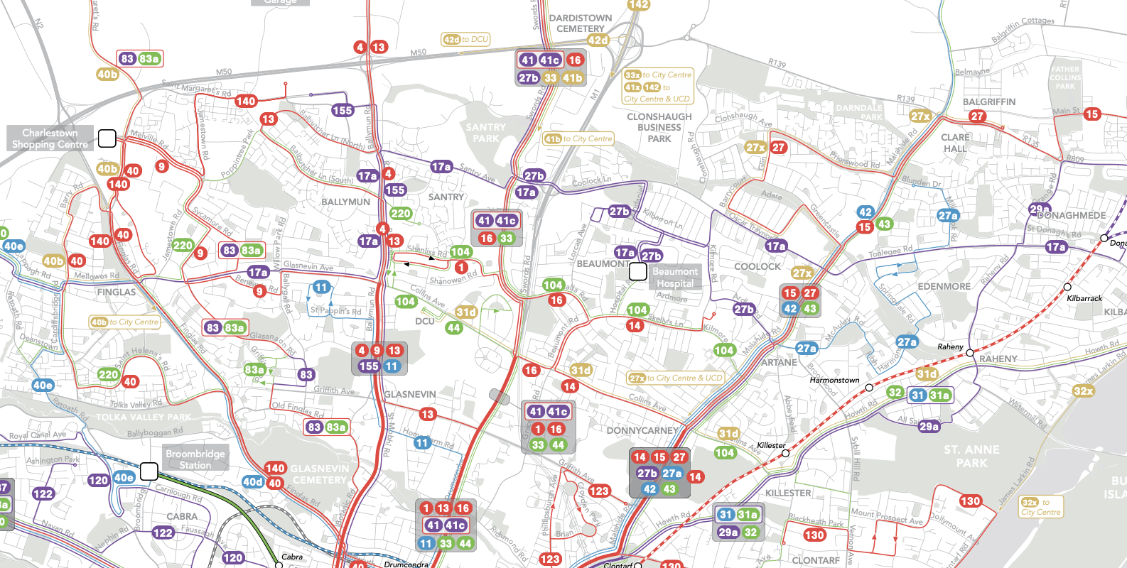
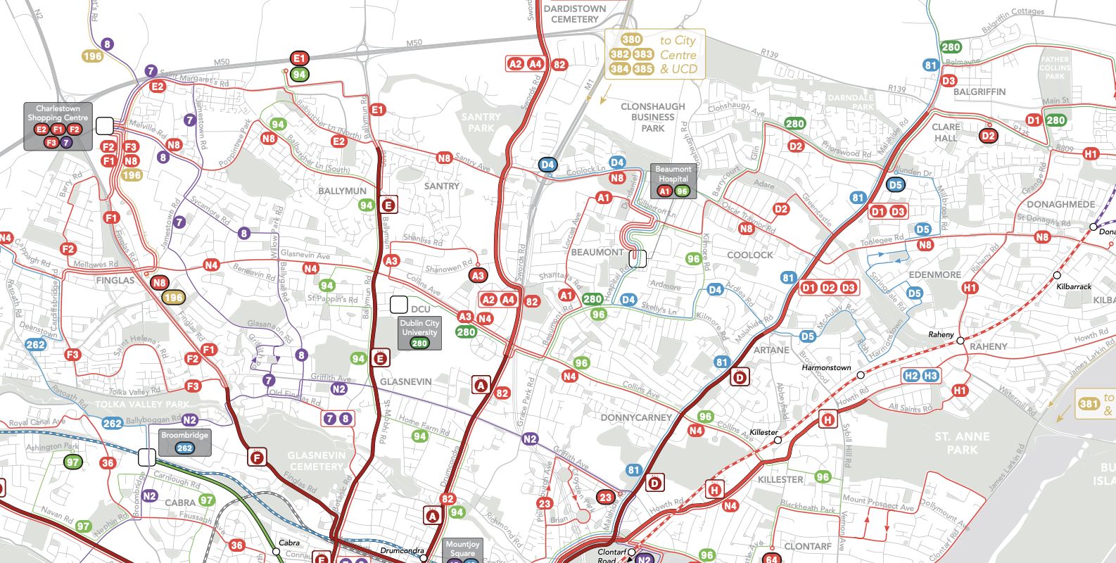
The problem of the pre-existing network was extreme complexity combined with remarkably low frequency. Although there were many routes running in various directions, the high-frequency network (where service comes every 15 minutes or better) was entirely focused on the city centre. Meanwhile, the complexity of the network was very high. Here is a small slice of the pre-existing network, for an area just north of the central city. Red lines indicate service every 15 minutes or better. Purple is every 20 minutes, blue is every 30, green is every 60, and pale gold runs even less often than every 60 minutes. (Click any image to enlarge and sharpen.)
Note that many of the major corridors leading south into central Dublin were served by a complex tangle of overlapping routes. These routes often did different things in the city centre, so that there was often no one stop where you could board any of the buses going out a particular major road.
After a comprehensive analysis of the existing network, we proposed four main strategies to make the service more useful to a greater number of people:
- Organize most radial services into super-frequent spines
- Redistribute service to create frequent orbital (cross-town) routes
- Increase frequency in outer areas by using feeders into suburban centers.
- Define a high-frequency service brand.
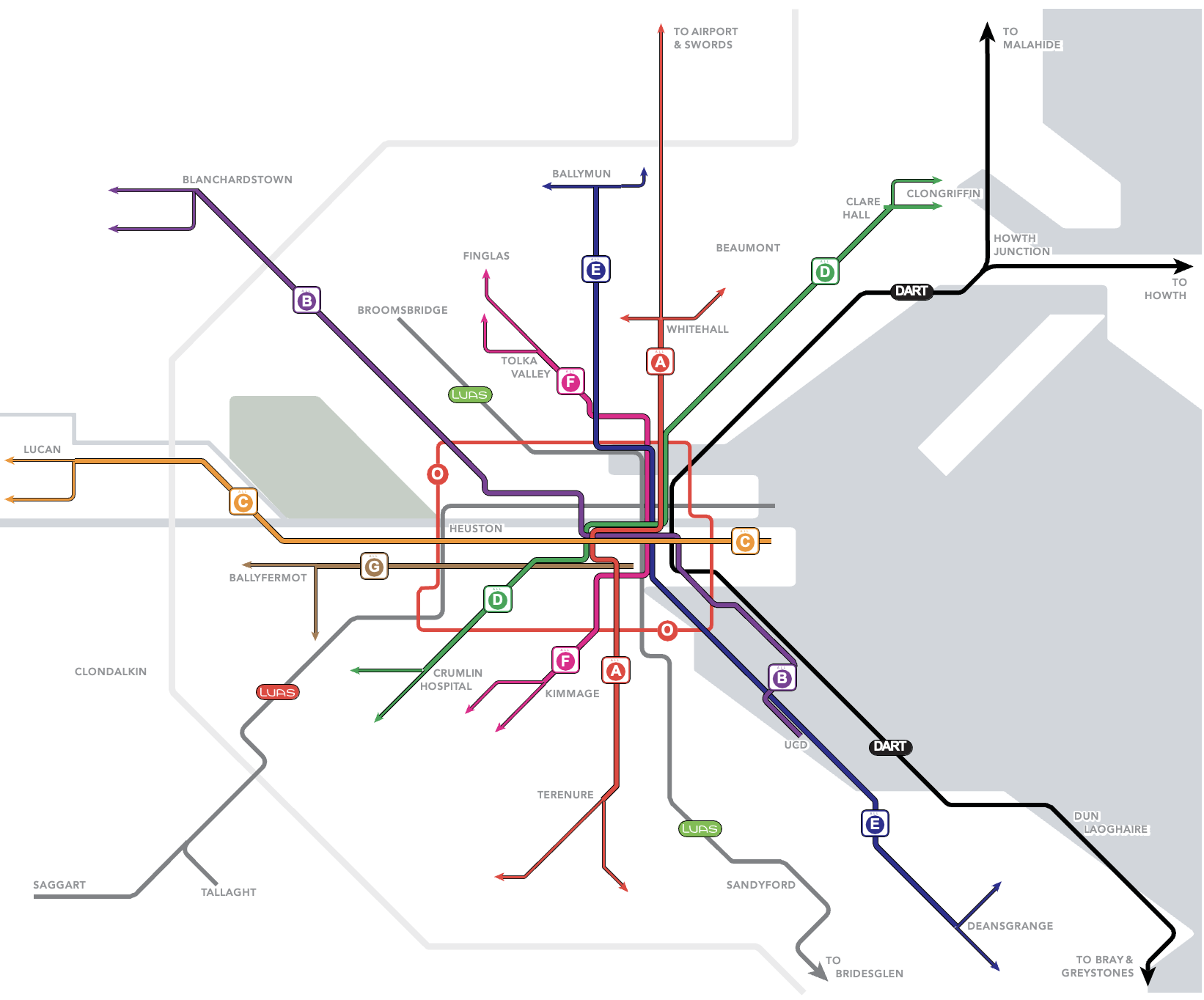
The spine concept looked like this. All service on each corridor was planned as a single extremely frequent line with branches. Letters refer to the spine and a number after a letter distinguishes a branch. Where all of a spine’s service is together, the user need only remember the letter. The result was a network for the central area that was extremely frequent (usually every 3-8 minutes) made up of a simple pattern of lines identified by letter.
Initial stakeholder and public outreach, carried out in the spring of 2017, showed overwhelming support for these strategies, particularly for the spines and frequent orbitals. Over 12,000 responses to an online survey were gathered within one month.
JWA facilitated a network design retreat with representatives from the NTA, Dublin Bus and the five local government authorities (Dublin City, Dun Laoghaire-Rathdown, Fingal, South Dublin and Kildare). This retreat and subsequent workshops brought the strategies to life as a complete proposal for a redesigned network.
The initial network proposal was released for public consultation in summer 2018.
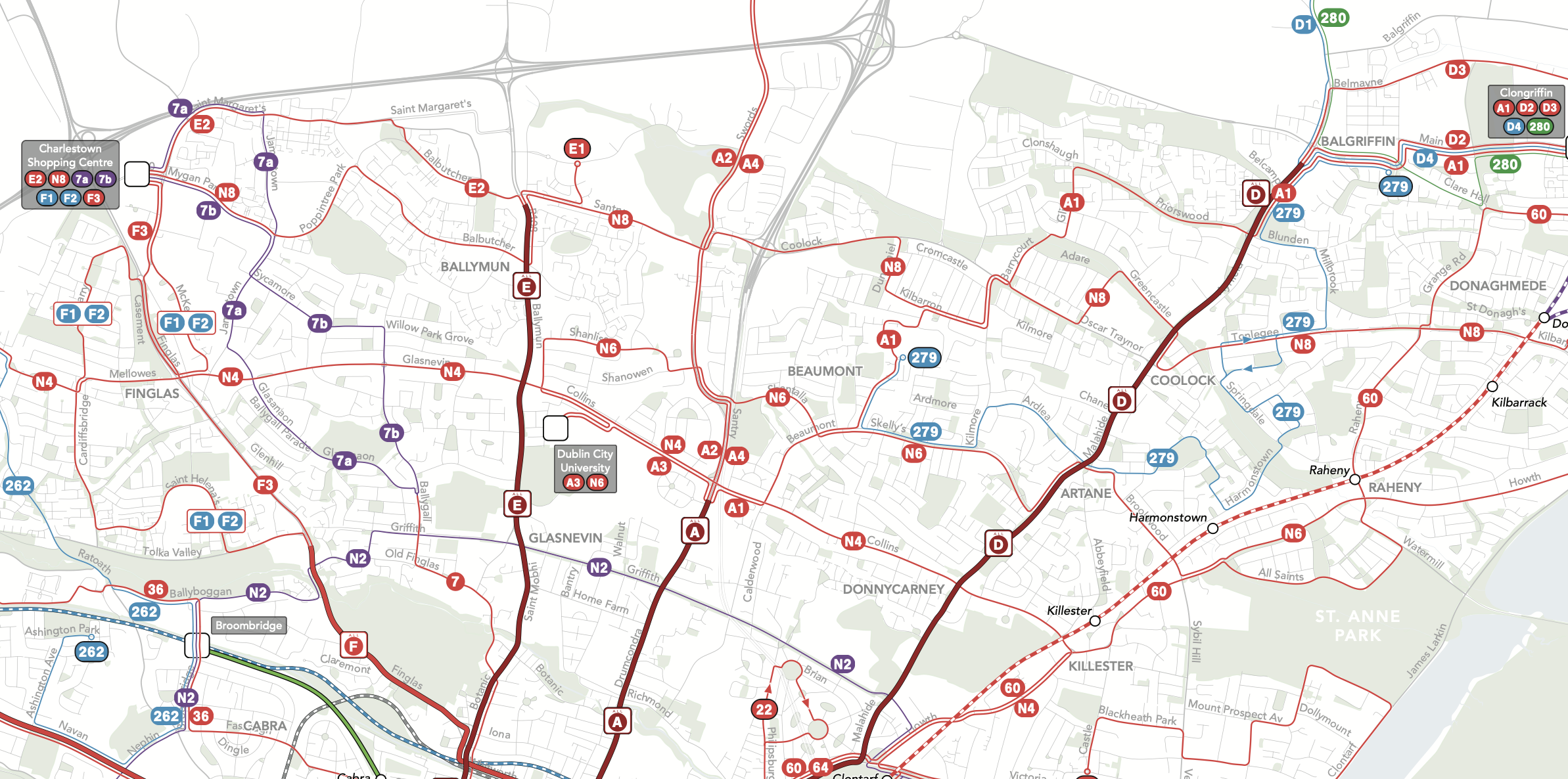
For the sample northern area pictured above, the 2018 proposal looked like this.
Compare this to the similar map above. This shows how the spines are designed to operate, including their patterns of branching. It also shows another key strategy: the creation of frequent orbital lines, which make frequent connections with the spines wherever lines cross. This is a high-frequency grid effect, which is fundamental to how the plan expanded the usefulness of public transport.
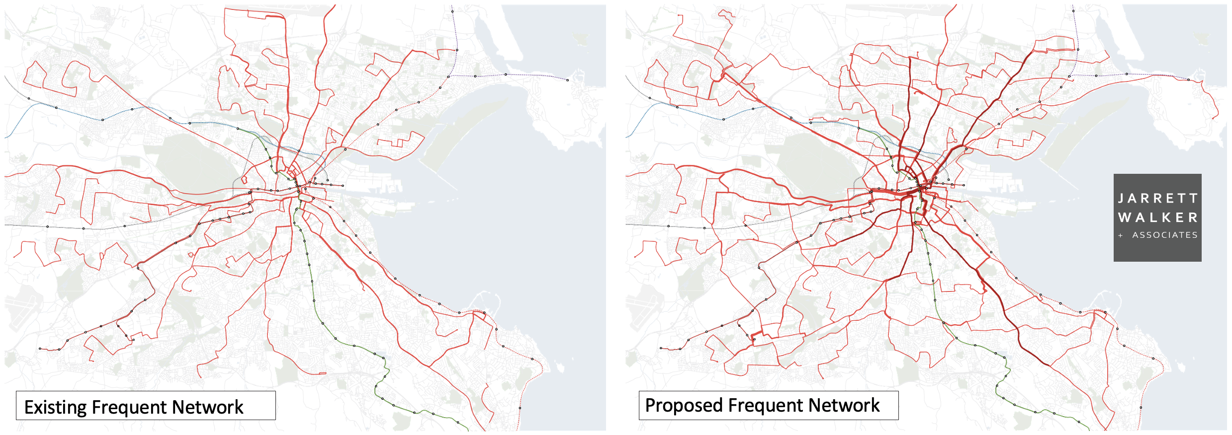
Zooming out to the citywide scale, these maps compare the network of high frequency services (every 15 minutes all day) in the pre-existing system and in our proposed network.
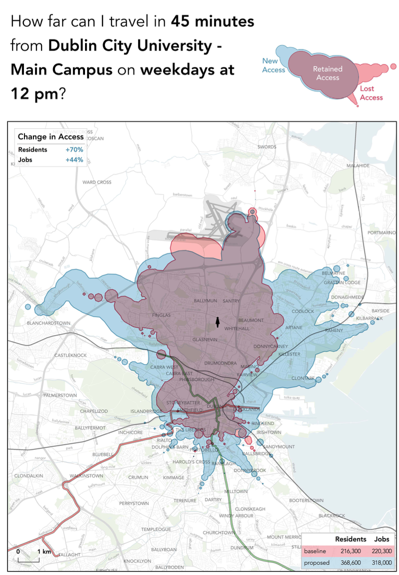
How much more useful was the service? For a hypothetical person living near Dublin City University (near the centre of the above image) the area they could reach in 45 minutes changed like this. (Blue is the area that this person gains access to within 45 minutes under the plan, while red is the area lost.)
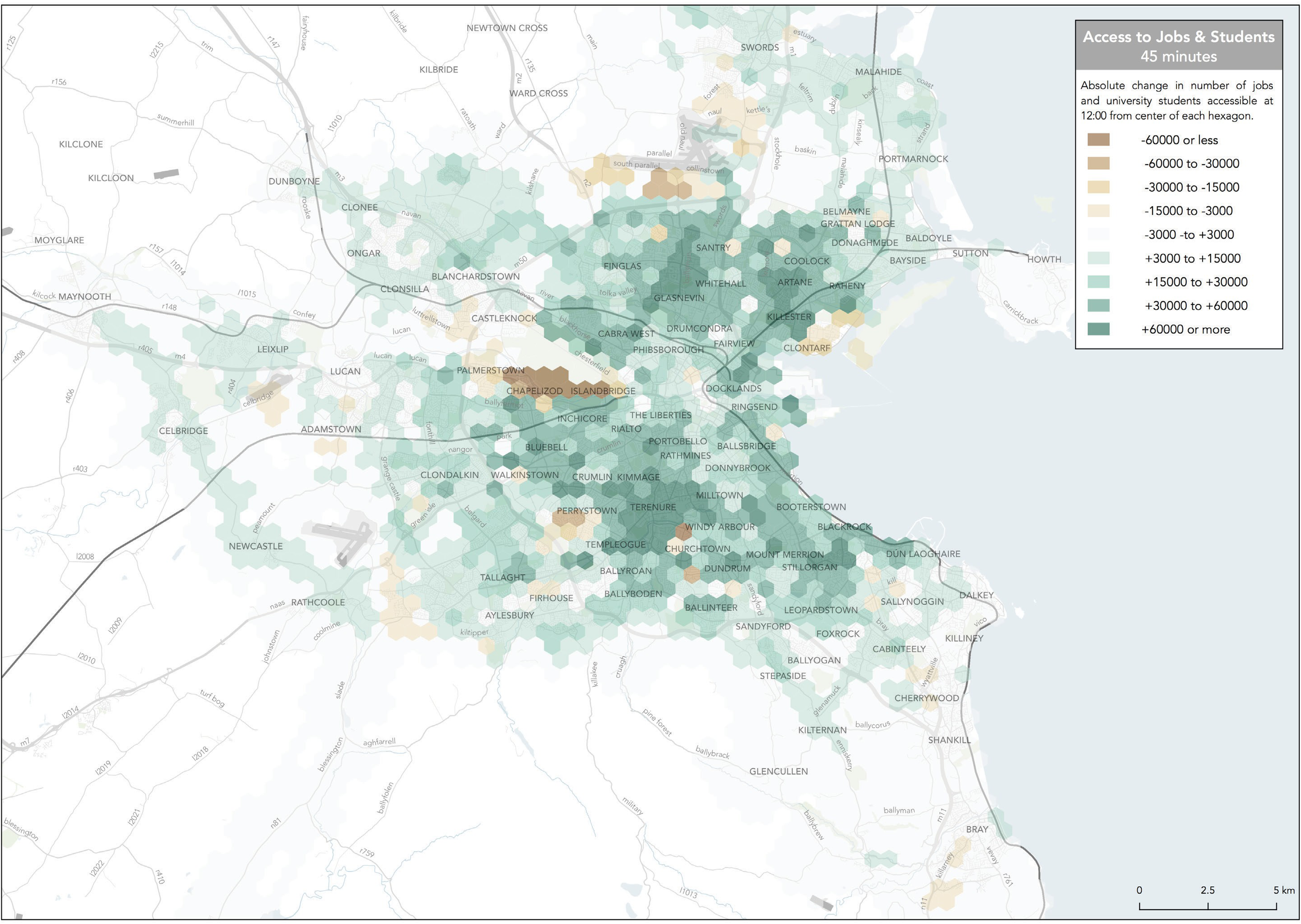
In the lower right, you see the expansion in access to residents (for a destination at this location, such as the university itself) and also the access to jobs (for a resident at this location.) Here, “jobs” also includes school enrollments. This image shows, for every location in the city, how much the access to jobs (and school enrollments) in 45 minutes expanded or contracted:
In general, there are relatively few people living in areas where the impact was negative. Overall, the average Dubliner could reach 20% more jobs (and student enrollments) in 30 minutes.
Over three months of consultation, NTA received approximately 50,000 individual comments and survey submissions. As expected, feedback was very lively, with many people objecting to the removal of various services. The draft plan had been defined as a 27% service increase, but for the final plan, the NTA decided to plan for a 40% service increase. This made it possible to restore services that the draft plan had deleted, without reducing the effectiveness of the planned frequent network of spines and orbitals. For example, in the same North Dublin area mapped above, the final plan looks like this:
You can see the entire 2019 final plan map here, although that map is drawn in a different notation that does not highlight frequency, as our maps do.
The revised proposal was released for public comment in October 2019; the proposed network included over 4.6 million annual revenue hours. The NTA began implementing the new network in stages, starting in 2021. You can find updates on the latest improvements at the Transport for Ireland BusConnects Dublin Bus Network Redesign page.
