How specific or vague should a transit plan be, before it’s announced? And what kinds of specificity matter?
It’s easy for a journalist to say that a plan is short on specifics, but all plans are short on specifics. If included every detail, you’d have construction drawings, escrow arrangements, employee work shifts, and so on. But that’s a lot of work, so you don’t do it until you’re sure you want to proceed.
Good planning starts at high altitude and proceeds downward through levels of detail until it’s ready to happen “on the street.” In transit, for example, it’s best if you first do big-picture city or regional plans, then implement these through local area or corridor plans, then implement these with more detailed design, then implement those with construction drawings or timetables. Finally you implement those by actually building or operating the proposed thing.
As you descend in altitude, you may hit a fatal flaw. You may have to back up to a higher altitude to see a way forward. But without altitude at first, you can’t see the big picture, and if you go into detail too soon, there’s a risk that the whole point of the plan gets lost as you quibble over a parking space.
So when a plan is announced, don’t jump to quickly to saying it lacks enough detail. We planners spend a lot of time trying to figure out exactly what to be specific about, and what can be left vague for now. Not out of any desire to mislead, but because it’s impossible to talk about all the details at once, and too expensive to study them all at an early stage. We rely on well-honed instincts: Which details are most likely to erupt into a problem — technical or political — down the line? Which other details can be noted and honored but left to a later phase to refine? These are some of the hardest calls that planners make.
 For example, I sympathize with the proponents of the recently announced Brooklyn-Queens Streetcar in New York, including the estimable Sam Schwartz, (“Gridlock Sam” at the New York Daily News) who advised the Mayor on the project and is also a leading advocate. Since it was announced a couple of weeks ago, civic leaders have lined up to support it but many leading transit advocates and urbanists have challenged the project, or at least raised hard questions about it.
I have been on both sides of these issues. But while every plan is going to be vague, it’s important to notice which parts are specific and which parts are vague, because this can signal something important about how the plan is likely to change as it goes through later stages of refinement.
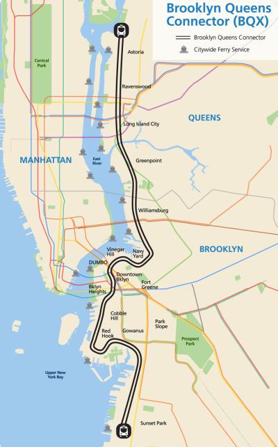
The mayor’s press release, including the map shown here, spends most of its length talking about why a certain area needs transit, and asserts that a streetcar is the answer. It assumes that “streetcar” will make us like the project before we know much about what it does. The release does include a set of travel time claims, but it doesn’t say much about:
- Frequency, which governs how long you’ll wait before you can even begin. (An ideal travel time estimate would always include half of that wait.)
- Connections, notably which subway lines the service would connect to. The curves on the map suggest but don’t imply any particular path, which would run on particular streets and connect with particular subway stations. I’m sure I’m not the only person who spent a while on Google Earth trying to figure out what these sensuous curves might mean in reality.
- Reliability, which generally requires exclusive right of way. The mayor’s press release says “majority of the line” is protected from car traffic. Other sources have told me anything from 70% or 100%. If it’s not 100%, it matters which 50-99% we’re talking about. Transit advocates have good reasons to be concerned about this. There are cases where transit can mix briefly with traffic and not be much affected – typically when the traffic is very low because the street is just for local access. But what tends to emerge out of the political process is exactly the opposite: Where traffic is bad, it’s politically hard to take a lane for transit, so transit ends up with exclusive lanes that disappear precisely where they are needed most. This is a very important part of the history of both streetcars and Bus Rapid Transit in the US.
- Fares. What will they be, and will it be free to transfer to the rest of the transit system, so that people can get to the 95+% of the city that’s not on this line?
If you just love streetcars, and want a streetcar, then these sound like the petty concerns of people who can’t see or trust your grand vision. But if you want an efficient transit network that liberates people to access opportunity, these things are paramount.
If the main goal of a project is to build a piece of technology, this sets up a risk that when hard choices have to be made down the line, the speed, frequency, and reliability will be sacrificed later in the project, as the “details” are being worked out. Suspicion about this is understandable, when you consider how slow and unreliable many US streetcars have turned out to be.
So how vague should a plan be? It’s a tough call. You have to be vague about something, but from that, people may reach judgments, fair or not, about what your priorities are.
“An ideal travel time estimate would always include half of that wait” — actually, it’s more than half. If a bus comes exactly every 10 minutes, then the average wait is 5 minutes. But if they bunch up so that 2 buses come every 20 minutes, then the average wait is 10 minutes. So the average wait is at minimum half of the timetable distance between buses, but it grows as the variance grows (that is, as reliability shrinks).
Indeed Jarrett, early stage plans will always be vague in some respects. But if they’re to form the basis of a funding decision then some critical aspects need to be quite well developed.
Here in Australia we’ve had some famous cases where multi-billion dollar funding decisions have been made on little more than a ‘line on a map’, by politicians searching around for palatable targets for stimulus funding. And now, according to a major report released last week, our Federal advisory body Infrastructure Australia believes it can assign individual projects to ‘Priority’ or ‘High Priority’ categories when most are yet to undergo any kind of cost-benefit analysis (and others with existing assessments have returned a benefit-cost ratio less than 1).
The usual expectation with such projects is that they move through successive stages of planning with steady increases in the level of detail and corresponding reductions in uncertainty in estimates of cost and benefit. And of course you try to identify potential ‘show stoppers’ at a very early stage so that these can be ruled out.
Of course, it’s also important when planning public works to be transparent about key parameters like future service plans, and about the modelling assumptions used to estimate costs and benefits, given how easy it appears to be to tailor these assumptions to fit a preconceived agenda.