For a while I’ve wanted to synthesize some material that’s scattered through my book (and more recent work) but that needs to be presented more directly. It’s long, but there are handy section dividers along the way, and pictures near the end.
When transit is planned with the goal of high ridership, what does that mean? When you tell network designers like me to maximize ridership, what do we do?
Maximizing ridership is like maximizing the number of customers for any business. You have to think like a business, and the first thing businesses do is choose which markets they will enter. Unlike governments, businesses feel no obligation to provide their service in places where they would spend a lot of money to serve very few people.
(Businesses also want customers to pay more rather than less, but for our purposes here let’s hold fares or prices constant, and just think about how you get lots of customers.)
Everyone understands that McDonalds is a business, which means it is under no obligation to provide a burger restaurant within 1/2 mile of every citizen. If they were, every ranch (population 4) in North Dakota would need to have its own McDonalds at the end of the driveway. Obviously the company would go bankrupt staffing all of these shops dotted across the prairie, miles from the nearest town, each with a smiling team waiting (and waiting, and waiting) for a customer to appear.
So in the real world of business, a rancher in North Dakota may have to drive 50 miles to find a McDonalds, because the only one will be in a large town where there are enough customers. We don’t describe this situation as McDonalds being unfair to rural folks, because we know McDonalds is a business doing what businesses do. Businesses deploy their product or service where it will succeed.
Transit agencies are not business, of course, so they often do non-ridership things for non-ridership purposes. We call these coverage services. I explain the tradeoff between ridership and coverage goals here.
1. To Maximize Ridership, Maximize Access
People will only use a service if it is useful, which means that it completes the trip they need to make, in an amount of time and money they can afford. Where ridership is low, it’s usually because the transit system just doesn’t do this for very many people.
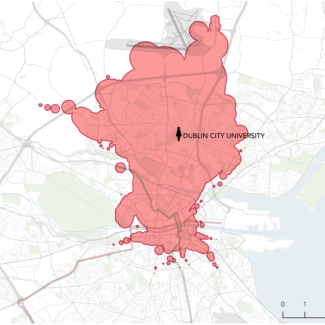
Jane lives near Dublin City University. In 45 minutes she could get to anywhere in the red area. The number of jobs and educational opportunities in this area is a measure of her access. Increase her access, and she’s more likely to find the service useful
So to increase ridership through network design, the key is to maximize access to all the things people travel to.. For every person, access is the number of useful destinations that they could reach in a reasonable amount of time. We can also talk about average access for everyone in an area, or for everyone in a demographic category such as race, age, or income.
For a fuller explanation of access, and why it’s so foundational to successful transport planning, see here. For now, the point is that when we design networks, expanding access is how we expand ridership.
2. Frequency Matters
Frequency is the elapsed time between consecutive buses (or trains, or ferries) on a line, which determines the maximum waiting time. People who are used to getting around by a private vehicle (car or bike) often underestimate the importance of frequency, because there isn’t an equivalent to it in their experience. A private vehicle is ready to go when you are, but transit is not going until it comes. High frequency means transit is coming soon, which means that it approximates the feeling of liberty you have with your private vehicle – that you can go anytime. Frequency is freedom!
At the opposite extreme, if you live in a single family house with a driveway and usually get around by car, imagine that there were an automated gate at the end of your driveway that only opened once an hour, on the hour. When it’s closed, you can’t get your car in or out. If that were your situation, your biggest transportation problem would not be traffic congestion, or how fast you can go on the freeway; it would be how to get this frigging gate to open more often. That’s how low frequency feels to a potential transit customer, and why frequency often swamps other factors, like speed, in determining whether transit is actually useful.
Frequency has three independent benefits for the customer, which helps to explain why high frequency is so critical to sustained high ridership:
- It reduces waiting, which is everyone’s least favorite part of a trip. (No, a smartphone that tells you when the bus comes doesn’t solve the problem of waiting; we are still talking about time when you’re not where you want to be.) The basic sensation of being able to go when you want to go is the essence of frequency.
- It makes connections easy, which makes it possible for a pile of transit lines to become a network. In transit, this is huge. A transit line without good connections is useful for travelling in one dimension, along that line. A network of frequent lines makes it easy to travel in two dimensions – all over the city, or at least all over the part of it that supports frequent service. This network effect massively expands the usefulness of every line in the network, thus increasing each line’s ridership potential.
- Finally, frequency is a backstop for problems of reliability. If a vehicle breaks down or is late, frequency means another will be along soon.
If you think about how these three things govern the real usefulness of transit, you can begin to see why frequency is such a ferocious ridership-driver. Notice that these three mechanisms are logically independent of each other, so they represent three different ways that a frequency change transforms the usefulness of transit for the better. So it helps to think of frequency as cubed value; its benefits tend to be exponential, up to a point, because improving frequency is actually three different improvements at once.
Here’s a simple scatterplot with a dot for each bus route in a whole bunch of US agencies where my firm has had occasion to collect data. Note that higher frequency (leftward on the X axis) correlates with high productivity (ridership per unit of service cost).
This is more amazing than it looks. Double the frequency of a line and you’ve doubled its operating cost, so you would expect high frequency to pull productivity down. And indeed, if you do that to a particular line at a particular moment, it usually does.
But overall and in general, high frequency correlates with high productivity, despite the high cost of the frequency. That’s because (a) frequency is such a powerful ridership-driver for the reasons outlined above and (b) frequency tends to be deployed where it will succeed.
How do we identify those places? Stay tuned.
Finally, the duration of service matters, and it works much the way frequency does. Service later into the evening, or on weekends, initially appears to be a bad investment, because we’re adding lots of service when there aren’t as many riders. But in the long run, its availability tends to correlate with high ridership. That’s because riders won’t use the service in one direction unless they can get back, so evening service, even if the buses aren’t full, is a key part of how we build high ridership all day. The same is true of weekends. If you commute five days a week including some weekend days – like many people in the retail, entertainment, or service sectors – you are unlikely to rely on transit unless it works for you on all of those days. One of the key features of our Houston redesign is bringing weekend service up to the same level as weekdays, so that except for the weekday rush hour, the bus comes the same time every day.
3. Diversity, Not Specialization
How do we network designers know where transit will succeed? You might assume that this is about detailed demographic analysis, detailed studies of travel behavior, and lots of conversations with citizens, finding out who people are and exactly what their needs are.
Well, we do a lot of that, and the data are interesting and helpful in resolving many details of a network plan. But in the end, it’s less important to high-ridership planning than a simpler question: “Where can we find lots of people, and places where lots of people are going, located in ways that are cheap for us to serve?”
The most successful transit, in terms of ridership achieved for a fixed operating budget, is called mass transit for a reason. The busiest transit lines – a big city subway system, for example – succeed precisely because they are not designed around the details of anyone’s needs. You will not get much assurance that planners of the system understand you in particular, or know what trip you’re making now, or care much about your unique point of view. Instead, you’re likely to notice how many different people are finding the same vehicle useful. You’re likely to notice diversity. We’ll come back to that.
At the opposite extreme, if you use a suburban or small town bus that never has more than five people on it, you may get very personal attention. The driver may even remember your name. But that charming fact is made possible by how low the ridership is.
As transit ridership potential goes up, responsiveness to each individual’s needs and desires goes down. The big-city subway doesn’t take care of your personal needs, but that’s inseparable from why it’s massively liberating to so many people.
It’s flattering to us, as individuals, to think that if transit just specialized more – just took better care of me or people like me – it would have higher ridership. That’s why we hear so much about it in the media – because it’s what we want to hear.
But specialization is simply not how the transit product succeeds at attracting great masses of people. Transit achieves high ridership by being useful and liberating to lots of people, not to any particular kind of person. High ridership arises from diversity, not specialization.
There are small exceptions, which happen when a large number of people are all doing the same thing at the same time. A big suburban school lets out at 3:00 PM, or the ball game ends at the stadium, or white-collar workers all want to get from an outer suburb to downtown at 8:00 AM. The “peak only” column in the scatterplot above shows some of those. But these exceptions are always about brief periods of time. What I’ve been talking about, everywhere but this paragraph, is the kind of ridership that’s sustainable all day and all week, and that supports continued growth into evenings and weekends to support an “18-hour” or even “24-hour” city. Specialization by time of day can fill some transit vehicles, but it’s a vastly smaller market (and a more expensive one to serve) than the kind of demand that’s happening all the time.
4. But wait, I thought ridership was about …
The notion that ridership depends on network design may be new to you. Haven’t you heard that ridership relies on having the right marketing, the right logo, an attractive vehicle, a courteous driver, or whatever? Well, those things can help, but only if the service is useful. Those features attract people to try transit, but people only use it routinely if it’s a good use of their time and money, day after day. Marketing can attract customers, but only the product will keep them.
What I am talking about, throughout this post, is the math of how we deploy service that’s useful to large numbers of people.
The core of being useful is being a logical choice, compared to your alternatives, for getting lots of places that you need to go. And since most of us are in a hurry, travel time matters. Frequency, for example, is an overwhelmingly important factor because it is so dominant in determining actual travel time in the urban context.
Here’s another thing that motorists and cyclists can get wrong: in a personal vehicle, your travel time is identical to the time spent in the vehicle, but in transit, your travel time includes waiting. Waiting is not just time spent at a stop; it’s all the time when you’re not where you want to be. In transit, the correct measure of travel time is forward from the moment you want to go (not necessarily when transit is going) or backward from when you really have to arrive. For example, if you must report to work at 8:00 AM but the hourly bus arrives at 7:05 or 8:05, then you’ll have a 55 minute wait at your destination. That’s part of your travel time because you’d rather have spent those minutes in bed. Do you still doubt the overwhelming power of frequency?
Another way to think about travel time is to turn it inside out, and think of it as “what places and opportunities can I reach in a given time, if I locate here?” Framing it that way helps us see how good transit (and good information) can guide people to locate based on where transit is useful, which is the ultimate source of the energy behind “transit oriented development”. I call that idea Abundant Access, and you can read about it here.
5. So Where Should We Run?
So to the extent that a transit authority is seeking sustained high ridership across long hours, it would focus its most powerful-but-expensive tools, high frequency and long duration, in the places where they can succeed.
Where are those places? Like any business, we need to put the service where
- (a) there are lots of potential customers;
- (b) those customers will be able to access our service easily; and
- (c) our costs of providing service are not too high, compared to the number of customers we’ll attract.
Now, let’s think about the high-ridership transit product. It’s simplest unit is a line or route with a number of vehicles running back and forth along it.
The cost of providing the service is based on the number of transit vehicles running along it (let’s call them buses, but all this is the same for trains or ferries as long as each one has employees on board. This number goes:
- Up with frequency. Double how often a bus comes, and you’ve doubled the number of buses on each mile of the line, doubling the cost.
- Up with distance. Double the length of the line and you’ve doubled its cost.
- Down with speed. Double the speed of the service, and the buses take only half as long to cycle the line as they did before, so you need only half as many of them to deliver the same service. You’ve halved the cost.
For now, let’s hold frequency and speed constant, and focus on distance. The key question for high-ridership transit, then, is “how far do we have to go to be available to a given number of people?” This is transit’s version of the question any business asks about a particular venture, like opening a shop in a particular place: “How much will it cost to be useful and attractive to an adequate number of customers?”
In transit, the answer is: It depends on the pattern of development, and especially on four measurable things:
- Density
- Walkability
- Linearity
- Proximity
Let’s look at each in turn.
Density
The image below shows two towns and a transit line running through them. The transit line in the two images is identical, so it has the same cost. But in the first town, the line is available to twice as many people, because the town is twice as dense. That means that if everybody in both towns had the same propensity to use transit, ridership would be twice as high on the first route as on the second. Since the costs of the two services are the same, the top town is twice as good an investment for the transit agency.
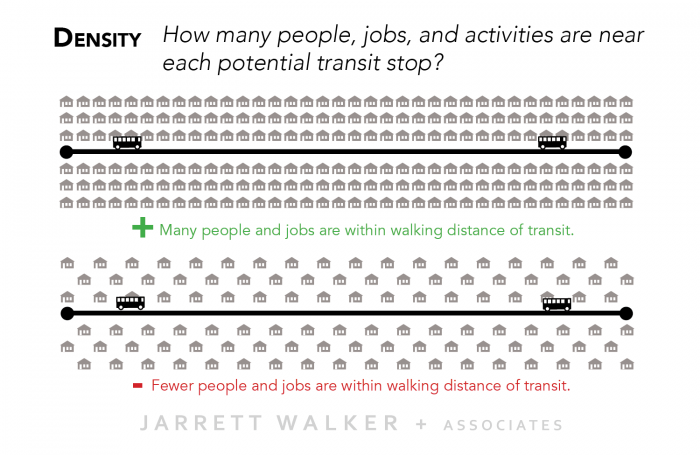
It really is that simple. Density means that any given service investment is useful to more people, so of course it attracts more riders.
In fact, density is even more powerful than that. We’re looking at two towns where everything is the same except that one is twice as dense as the other. But in fact, this difference in density generates other important differences that also tend to increase ridership. Parking is more difficult or expensive, and because more things are in walking distance, people are more likely to walk or cycle short distances. People without cars (because they can’t drive, or can’t afford one, or simply don’t want one) also logically choose to locate in higher-density areas where transit, walking, and cycling are easier, and this further reinforces the ridership from these higher density areas. So in many cases, we find that the difference in ridership between these two towns is more than double. It’s double just because there are more people, but in addition, each of these people is also more likely to use transit, because of these other factors that also track with density.
So can we get high ridership out of low density ? Only if we can create artificial density of demand around a transit line or stop. Park-and-Ride, for example, is a way to get people from a low-density area to gather, densely, around a transit station, so that they justify intense service. Park-and-Ride raises other challenges because of the space it takes, but there is a huge range of potential non-transit solutions for giving people ways to get to a transit station, including bike-and-ride, roles for private sector demand-responsive service, and others. From the customer perspective these are called “last mile” solutions. But for a ridership-mazimizing transit authority, these are ways of creating the density of demand, at a transit stop, that makes good service viable, even though that density is not present in the land use.
Walkability
In the drawing about density I assumed that people could walk to the transit line easily, but that’s not always true. The local street network, and the design of the street that transit runs on, determine whether it’s possible to get to the service. People who can’t get to the service aren’t going to be riders, so this impacts ridership directly.
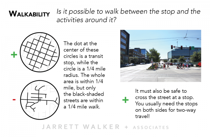
In this diagram, the two circles on the left have a gray dot in the center, representing a transit stop. The circle is the area that is within a reasonable crow-flies distance of the stop (say 1/4 mile, but it doesn’t matter what you think this distance is).
The circle is a very crude measure of the area where people might find this transit stop useful. However, if you are only willing to walk a certain distance, say 1/4 mile, then the real limit is how far you can walk along the available streets and paths. The streets shaded in black indicates the parts of the neighborhood that are within 1/4 mile walk of the stop, not just 1/4 mile by air.
The local street network makes all the difference. In the neighborhood on the top, the gridded street pattern puts about 2/3 of the circle within walking distance, while the disconnected suburban street pattern on the bottom puts only 1/3 of the circle within walking distance.
So if all other things are equal, including density, the neighborhood on the bottom will have half the ridership potential as the one on the top. That means that a transit agency focused on ridership will deploy much more service to the neighborhood on the top than to the one on the bottom.
Another important dimension of walkability is whether you can get to the transit stop in the correct direction. When transit runs on a major street or road, the stops in the two directions of travel are on opposite sides of the road. If you want to make a round trip by transit, you will leave from one side of the road in the morning and be dropped off on the other side in the afternoon. So it has to be possible to cross the road, as a pedestrian, at the stop.
Again, if this is impossible, because there are no signals or other crossing provisions near the stop, then you should expect a ridership-maximizing transit planner to run less service. Some transit professionals argue that transit should never stop where it’s not safe to cross the street, because when pedestrians are hit by cars in this situation, the transit agency is sometimes held liable for having put a stop in an unsafe location.
Linearity
In the image below, two towns are made up of the same four centers of development. Maybe one is a college, one is a shopping center, one is a mass of apartments, or whatever. In any case, the two towns are identical except for the locations of the four centers.
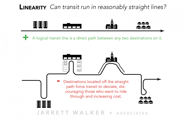
In the first town, the centers are in a reasonable straight line along a path that transit can follow. That means that a single transit line connects all four centers, in a way that feels reasonably direct for travel between any two centers.
In the second town, a single line connecting all four centers is maddeningly circuitous, and therefore much less attractive if you’re traveling between centers that are not adjacent. There would be another solution for the second town, which is to run a direct bus route between each pair of centers, bypassing the others. But that’s more route-miles, and hence less frequency and duration of service for a given service budget, and hence service that’s less likely to be useful to many people.
Putting development at the end of a long cul-de-sac makes it a worse prospect for ridership, which means a ridership-maximizing transit agency will give it less service. Remember: if you want good transit, locate “on the way” between other places that support good transit.
Finally, notice that you can create the same problem by slowing down a transit service, as road-dieters, traffic-calmers, and bike-lane advocates often inadvertently do. Look at the first town, but now imagine that the two centers in the middle of the line have slowed down the transit service as it runs through them. For ridership, this has exactly the same effect as the layout of the second town: it turns the middle centers into obstacles to travel between the outer centers, discouraging the use of transit for travel between them. (The outer centers will demand an express bus to get around the obstacle, but again, solving the problem with more lines means you can afford less frequency, so service is less useful, thus ridership will be lower.)
Proximity
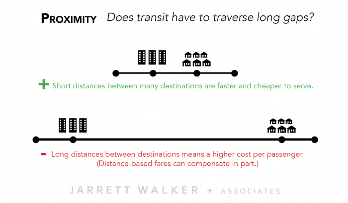
In this image, two towns are identical except for the distance between the main residential area and the main business area. Longer transit lines cost more to run than short ones, so in the second town it will cost more to serve the same number of people. If a transit budget is the same in the two towns, the second town will have less frequent service or service for a shorter duration. That’s because the same resource is spread over more route miles, yielding less frequency. That, in turn, means lower ridership.
6. Summing It Up
If you come from a neighborhood that looks like the second town in one of these drawings, how did you react to these images and explanations? Did it sound like I was criticizing your home, or saying you shouldn’t have transit service?
No, those would be aesthetic or moral judgments, and that’s not my job. My job is to explain how transit is designed if high ridership is the goal. I’m not saying that ridership should be the goal – a moral judgment again – but only that if it’s the goal, this is what transit would logically do. It would look for markets that offer density, walkability, linearity and proximity, and focus excellent service there. Where those features are absent, it would recognize that ridership potential is lower regardless of the service provided, so it would deploy little or no service.
This is how businesses behave, by choosing the markets they will enter, based on where the conditions are right for them to excel. Do you want transit to carry as many people as possible? To what extent do you want that? That’s up to you, and your community.