Today, the city buses in Madison, Wisconsin began doing something new, thanks to a network redesign project that our firm developed with our friends at Madison Metro. Core parts of the network will run frequently all day for the first time. More important, many travel times across the city will be much faster, because the plan deemphasizes four satellite transfer points that had been a big source of delay.
Here’s the city’s map of its new network. (Click to enlarge, or see the original here.) Lines A, B, C, and D are all frequent (every 15 minutes all day) out to the point where they branch. (A1 and A2 refer to branches of Line A.)
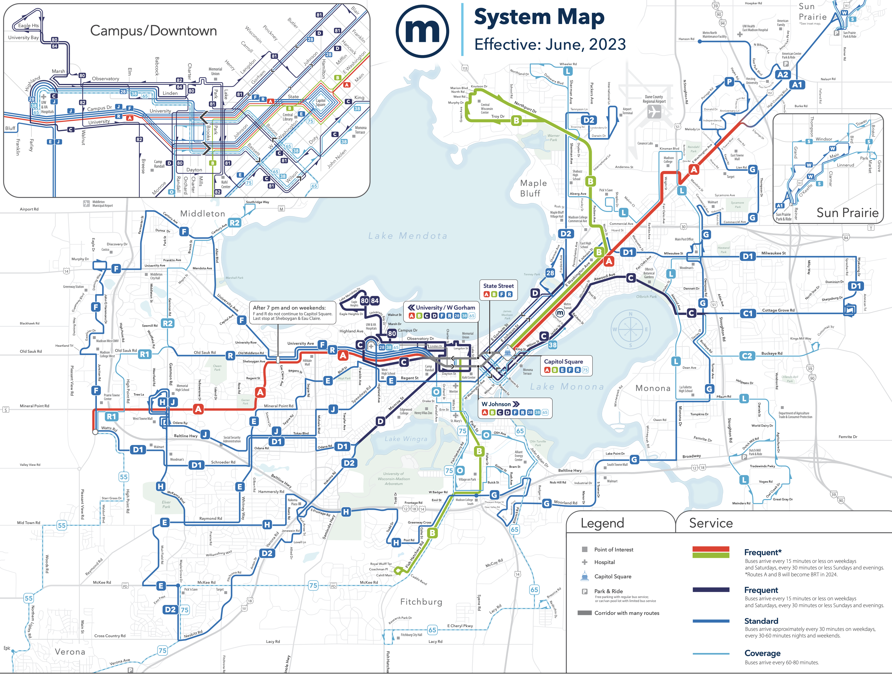
Line A is designed to match the path of the forthcoming Bus Rapid Transit project, while Line B is the next BRT project after that one.
How much better is this? Here was the old network, in our style where red lines indicate high frequency:
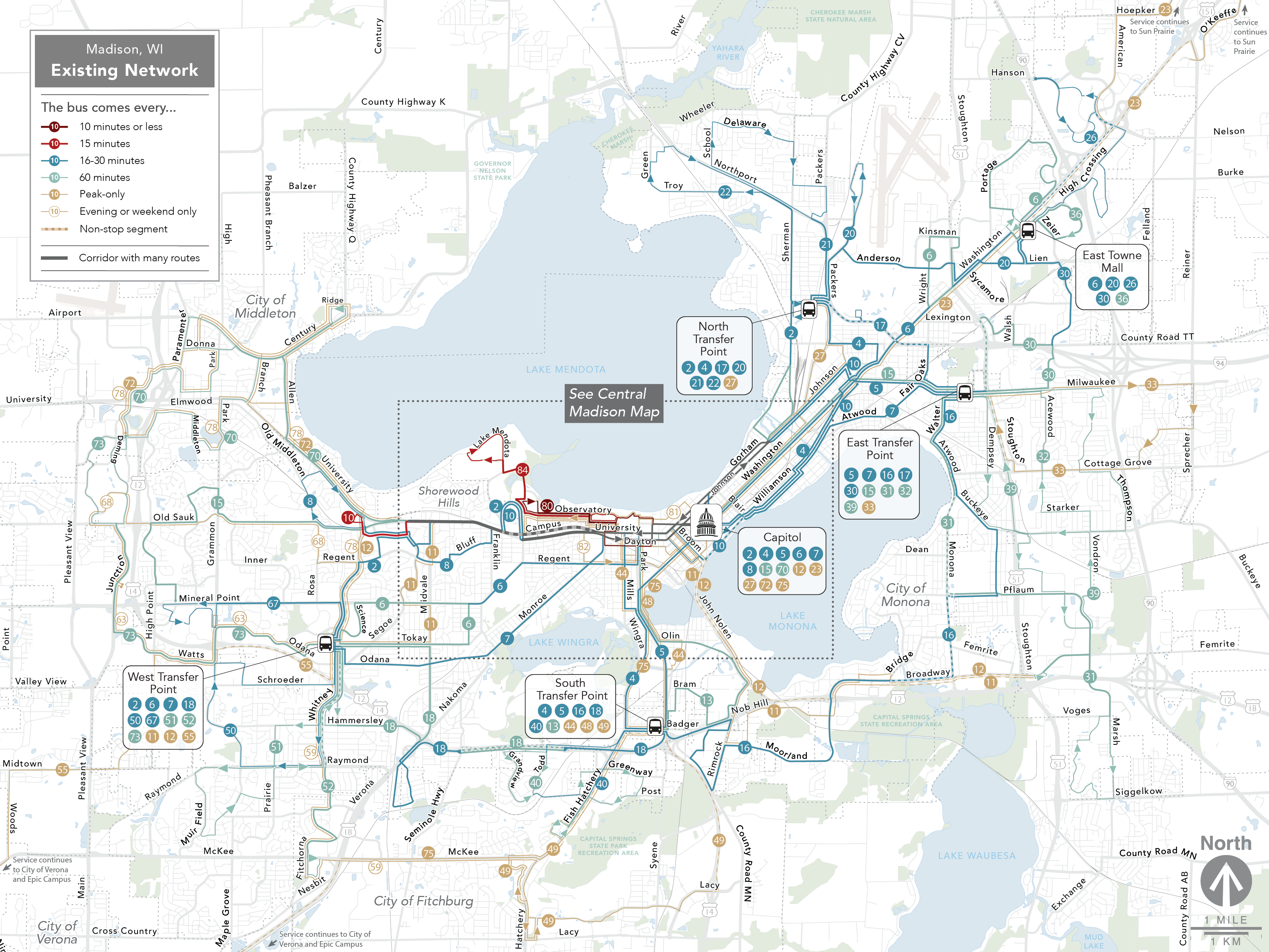
The old network was all infrequent, except for the University of Wisconsin’s shuttle routes 80 and 84. The new network, by contrast, has four frequent lines (A-D) covering all of the densest inner city and radiating outward in several directions. But the oddest feature of the old network was the four satellite transfer points located just a few miles out from the city center. Most of the outlying area was on feeder routes, requiring a connection at one of these points just to reach downtown or the University of Wisconsin. These points did make it easy for people to travel locally within their area, but on balance, they did more to obstruct trips than they did to enable them.
Our plan largely deemphasized these facilities. Now, most of the city is on a direct route to the center, with much faster travel times. Satellite hubs can be valuable to foster a network that serves trips in many directions, but the South, East, and North Transfer points were too close to the center to serve as good hubs, and none of them had significant destinations at them that could benefit from the converging service. East Towne Mall, further out to the northeast, has a better future as a hub, both because it’s far enough from downtown and because it is a destination in its own right. The same may be true of West Towne Mall on the west side (where the new network’s A, H, and J routes converge.) However, even if those hubs emerge, the main radial services (Line A) will flow through them, not be interrupted by them.
We had a great time working in Madison. The city has many engaged advocates and stakeholders who provided great feedback, and many elected officials gave the project a lot of time and attention. We hope the new network will help people in Madison go to places they’d never have gone to before, to do things they might never have done.
This definitely looks like an improvement.
Do the maps display combined headways? For example, it looks like the 6 on the old map branched on both ends. Each branch had 60 minute headways, and when it combined, it had 30 minute headways. That being the case, did the buses really fail to combine for 15 minutes headways through the isthmus?
Hi I’m a resident of Madison, and I’m really excited for the new network. There is one issue that has not been addressed though that affects my family: there is no bus from the west of Madison (near hilldale) that goes to the hospital loop. Moreover there is no bus connection that can take a rider from the bottom of the hospital loop to the to the top of the loop, but there are atleast 3 routes that can take you up to loop from the east side. There seem to be some buses that go up the loop from the west side (university bay) but there timings are out of sync with the buses that bring you to that stop from the west. I hope you address this gap when the city takes stock of the routes
What made you decide not to connect the F and H? It looks like that missed connection hurts north-south journeys in the west side of the city. Something like Middleton to the Elver Park area requires either two changes, a mile plus walk somewhere, or a fair detour to change downtown. Does that connection not actually improve access as much as it looks, or was it rejected for other reasons?
@Thomas: As a Middleton bus rider, I’m guessing at least part of it is that most north-south journeys on the west side stop around the Beltline; the Elver Park area is mostly residential, and the businesses replicate closer alternatives, so neither group needs to go to the other. It’s also not marked, but the entire center of Middleton is a conservancy park, maybe half the size of the UW Arboretum.
The Metro project manager did ask about the value of R (especially R2) being a north-south route, but anecdotally my experience is that existing users of the system are depending on it being another east-west route (and we might also need it for capacity that way, at least for now) and adjusting it would take a lot of adaptation.
@RossB: functionally, yes, most of the buses failed to combine for better headways. They were scheduled around timed transfers at the transfer points (including Capitol Square), so the headways were erratic on combined routes. Assuming you could even use the other buses on that route to get to your destination.
BIG DISAPPOINTMENT. Walker used to be a friend of transit. Now, he’s helping dismantle it.
The top image is clipped, you can’t see the the full legend or the 75 in southwest.
Ah, so if I live on Maple Grove, all I need to do to get to Middleton (a 15 minute drive on the same side of town), all I have to do is walk the better part of a mile to the E route, then transfer to the H, then transfer to the D1 or the A, then transfer to the F. How long would that even take? Imagine doing 4 transfers on 5 buses on a day with a negative 40 degree windchill.
That’s 3 transfers, not 4. You could also take the E to University at University Bay and transfer to the F which is only one transfer. This is at least better than the previous network which had no buses at Maple Grove at all.
As someone who was a Route 6 user to get from here to the Capitol and back, this is not an improvement at all.
I’m quite curious to know the rationale behind how some of the “standard” (every 30 min) routes were identified by letter, rather than number as usually is the practice for “standard bus” routes elsewhere. What’s the common feature between say, the E bus (a standard) and the A/B (frequent and to be upgraded to BRT) that warrants the common letter branding?
I think it’s a step in the right direction for Madison (my hometown) but I would be interested to know why a letter-based route naming was introduced.
I also just need to say that as a former resident of Jenifer Street on the near east side, the C (former 4) really should be on Willy. If there are traffic concerns, the city should be using the current “no rush hour parking” curb lane as a rush hour bus lane. Willy is both the commercial and cultural heart of the neighborhood, having no buses on it makes transit feel de-prioritized. I suppose most of that is likely beyond your control though.
And on a personal note, the lack of State/Downtown service on the J (former 6) is a bummer. A few of my friends live in the area around the Speedway/Glenway intersection and the loss of direct downtown bus service is very significant for them.
Overall, I like the changes – though I have strong opinions on the lack of good BRT especially on the western end of things. No bus lanes on University is bad for bus riders!
As a person who spent a lot of time in Madison between 1989 and 2003, I remember the bus routes were lettered until sometime in the late 1990s. Most buses were downtown-centric and transfers were usually at Capitol Square. Then there was a major restructure which brought in the transfer points. That’s when they went to numbers. I suspect going back to letters is intended to break people of thinking in terms of the routes as they were before the change, to avoid confusion.
I lived in Madison until early 2022, and I can say for any of the regular trips my wife and I made on the bus, the new system looks like an improvement. Excellent work, sir.
Madison had broad route coverage, but long, long wait times — a half an hour between buses on most routes, sometimes an hour. Ouch. This might involve some longer walks, but the tradeoff is that you’ll get where you’re going quicker and with less standing around.
Always hated the transfer centers, by the way. Madison isn’t big enough to warrant them.
What is the purpose of route 28 and 38? They seem to be unnecessary duplication of more frequent routes, especially the 38 which is only every 60 mins but runs parallel 15-minute routes like C and 80 all the way.
The map is a lie. It says that route E should be every 30 minutes during weekdays but it actually only goes every 60 minutes during midday, it has 30-minute service only during peak hours.
Previously lived in Madison for a number of years, rode on the buses there, and while the city has a horrible problem with suburban style winding street networks and general lack of walkability that don’t play nice with transit, it helps fix the really unfair lack of frequent service to the south and north sides. Having this then would have made my life so much better.