Tag Archives | Density

The rise of “Super Commuters”

The Apartment List Rentonomics blog, which writes on real-estate statistics and economics, recently posted a census analysis on the “Rise of Supercommuters”.  It describes a recent increase in the percentage of people with commutes 90 minutes or longer each way.  This thoughtful analysis is well worth a read.  It finds that:

  • Nationwide, one in 36 commuters are super commuters, traveling 90+ minutes to work each day, spending hours on public transportation or battling traffic.
  • Super commuting is becoming increasingly common: the share of super commuters increased 15.9 percent from 2.4 percent in 2005 to 2.8 percent in 2016.
  • The share of super commuters is highest in expensive metros with strong economies — New York, San Francisco, Washington, D.C., Atlanta and Los Angeles, and in their surrounding areas.
  • Super commuters are more likely to rely on public transportation than those with shorter commutes. An estimated 91.4 percent of non-super commuters drive to work, compared to just 69.7 percent of super commuters.
  • In most U.S. metros, low-income commuters are more reliant on public transportation than high-income commuters, creating a nexus between super-commuting and poverty. When transit usage falls sharply with income it suggests that transit is used out of financial necessity rather than as a lifestyle choice.

But the term “Super Commuter” sounds too heroic.  “Super commutes” aren’t something to celebrate.  People should be free to arrange their lives this way, but shouldn’t be forced to by the housing market.

For the commuter, spending three hours of unpaid time a day commuting is only a response to a lack of reasonable alternatives.  For taxpayers, it represents a high cost- both in providing infrastructure, and in increased traffic congestion.  The US Census itself calls commutes over 90 minutes “Extreme commutes”.  That to me, better describes these long commutes- they are something that a few people may have to do because of their job or family situation, but something that shouldn’t be made the new normal.  “Extreme” also captures the right connotation.  As in “extreme sports,” it suggests something that most people would rather watch than do, and that many don’t even want to hear about.

We can also draw parallels between increases in in the prevalence of these extreme commutes and the decrease in overall transit ridership over the past few years.  They are both symptoms of the suburbanization of poverty, and to some extent, the middle class.  These suburbs are not geometrically conducive to high-ridership transit, and as a result the transit options are poor, so many people who move there, resort to driving.  But driving such long distances every day can cost thousands of dollars over the course of a year, so some people would still rather endure the low frequencies and limited spans of suburban transit service to access the city.

The article goes on to conclude that:

Reversing the growth in super commuting requires investment in both increasing housing supply and improving transportation.

Both increasing housing supply and improving transportation have the potential to reduce commute distances, but the location of this new housing and improved transportation are crucial.  Transit always achieves higher ridership per hour of service in dense, mixed-use urban centers, than in unwalkable outlying suburbs, so if we want to reduce the percentage of transit commutes that take more than 90 minutes each way, we will have to substantially increase densities in places where fast, frequent, and useful transit is most feasible.  That means a mixture of housing and jobs, and building up, not out.
 

Toronto: A new King Street for Transit

By Christopher Yuen

For the past few decades, Toronto’s King Street, a frequent transit corridor through the densest and fastest-growing parts of the city, has been increasingly choked by car traffic. Built before the age of the automobile, and running in mixed traffic as was typical with legacy streetcar systems, the 504 King streetcar’s speed has deteriorated to just about walking speed on most days during rush hour. That was until three weeks ago, when the City of Toronto launched a one-year pilot project to restrict car traffic and give transit the space it needs to move. The Globe and Mail has a great piece on the significance of this project here. Details on the project and its design are available at the City of Toronto website here.

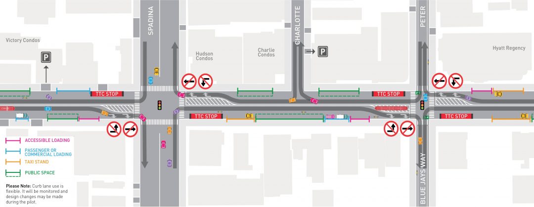
King Street Pilot Plan Diagram excerpt

The King Street pilot project prioritizes transit.

The new design of 4-lane King street was particularly thoughtful, given some of the constraints the corridor faces. While transit malls in some cities completely ban non-transit vehicles, existing high-rise parking garages that front onto King Street and businesses throughout the bustling entertainment district without back lane for loading and deliveries meant that vehicular access had to be maintained. Under the new design, left turns and through-travel are prohibited for cars and trucks at all major intersections- requiring drivers to turn right and use alternate streets.

At the approach to intersections, vehicles waiting to turn right form a queue in the right lane, out of the way of transit. At some intersections, cars receive an advance turn signal ahead of pedestrians to ensure the tail of the turning queue does not impede the streetcars.

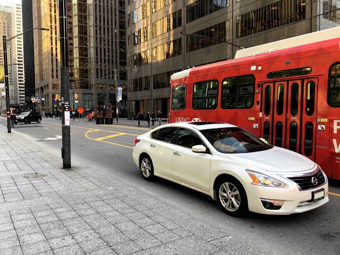
Taken on a weekday at 4:00pm, this scene would have been much more chaotic with through-traffic blocking transit before the project. Now, cars are channeled to turn right at every intersection. (Photo: Alex Gaio)

Taken on a weekday at 4:00pm, this scene would have been much more chaotic with through-traffic blocking transit before the project. Now, cars are channeled to turn right at every intersection. (Photo: Alex Gaio)

Without through-traffic, having two lanes at the start of each block is no longer necessary, allowing for an important feature for efficient transit operations- far-side stops. Streetcar tracks in Toronto, and in many legacy systems, operate in the middle of the road. To board and alight, passengers must step into the roadway, protected only by a rule prohibiting motorists from passing open streetcar doors. As a result, stops have always been located on the near-side to reduce the risk of drivers making a right turn onto a transit corridor and immediately conflicting with passengers getting on or off a streetcar. Under the new design, streetcars stop on the far side of most intersections, beside barriers that effectively extends the curb to the second lane at the start of each intersection.

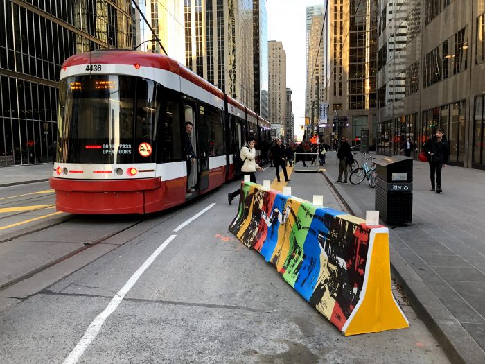
New far-side stops with a temporary curb-extension mean passengers no longer have to walk through a traffic lane to get on and off the streetcar. (Photo: Alex Gaio)

New far-side stops with a temporary curb-extension mean passengers no longer have to walk through a traffic lane to get on and off the streetcar. (Photo: Alex Gaio)

In addition to the obvious safety benefits of the new design, the far-side stops also allow transit vehicles to travel faster. Traffic signals along Toronto’s King Street already feature transit signal priority- they detect an approaching transit vehicle to hold a green light, or shorten a red light. With near-side stops, the unpredictable dwell times at stops would sometimes cause the traffic-signal to time-out, leaving the transit vehicle with a red light just as it closes its doors and is ready to get moving. Far side stops allow signals to be held for a streetcar to get through an intersection before stopping for passengers.

The new design also re-allocates curb space as loading zones, taxi stands and for new seating and patio space mid-block- all valuable features for a dense, mixed-use central business district which would not have been possible when all four lanes have been dedicated to the throughput of cars.

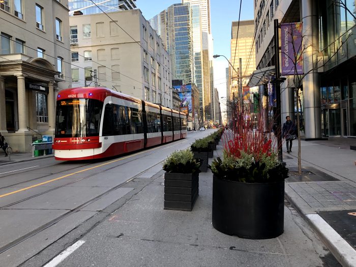
New public spaces like this will become especially valuable when patio season begins.

New public spaces like this will become especially valuable when patio season begins. (Photo: Alex Gaio)

Since its launch, public support has been for the most part, positive. The all-at-once approach to implementing this pilot across the corridor has ensured that the new inconvenience to some drivers has also been matched with a drastic, noticeable, and immediate improvement for everyone else. Across the twittersphere, Torontonians are reporting anecdotes of more consistent departures and trips taking half as they did previously.

Even among some taxi drivers, subject to the same turn restrictions throughout the day, initial skepticism appears to have eased.

Preliminary analysis of GPS data shows that the project is working, significantly reducing both the average and the spread of travel times.  However, it remains to be seen if enough drivers will comply with the new restrictions once the initial enforcement blitz is over. If New York or San Francisco‘s bus lanes offer any guidance, Toronto should introduce automatic camera enforcement along the corridor. Over the course of this one-year pilot project, municipal staff and the transit agency will be sure to monitor the situation closely and make adjustments based on actual results.

Cities, faced with growing populations and spatial constraints, must defend the right for transit to move if they wish to limit the negative impacts of traffic congestion. Toronto’s King Street offers a story of how that can be done quickly and effectively.


Christopher Yuen is an associate at Jarrett Walker+Associates and will be regularly contributing to this blog.