[Updated 2018 Aug 8]
For 18 months, our firm has been working with National Transport Authority of Ireland (NTA) to develop a redesign of Dublin’s bus network. We studied every bus route, drew hundreds of maps of data and ideas, and spent a week locked in a conference room with experts from NTA, the bus operating company Dublin Bus, and staff from the local governments. Once we had a rough plan we spent more months refining and analysing. It’s been a long voyage to this point.
The plan is now released for public comment. The plan revises the entire network, creating a much simpler pattern that people can learn, remember, and explain. A vast high-frequency network, in a spiderweb grid pattern, extends across most of the city, dramatically improving travel time for journeys in many directions.
Our key goal was improving access. We wanted to speed up people’s trips, but we prefer to say that we wanted to expand the range of places that could be reached in a fixed amount of time. We wanted people to get to more places, sooner, so that they would have more opportunities in their lives. In short, we want public transport to give people more freedom.

Here is what we were trying to do. Under the plan, in 45 minutes of travel time, a person near DCU gains access to the blue area and loses access to the red area. That means she can get to 44% more jobs and student enrolments (and other useful places). That’s freedom and opportunity! The average result across all of Dublin is a 20% growth in where you can get to.
Under the plan, the average Dubliner can get to 20% more useful places in 30 minutes. “Useful places” means jobs and student enrolments, which are easy to count with Irish data, but of course you can expect similar results for shopping and for all kinds of other destinations that give value to our lives.
There are many ways to explore the new network, including maps, frequency tables for every hour of the day and week, and an interactive map tool that shows where you could go soon on the proposed network, and how you might get there. You can also look at a table showing how the plan affects every segment of every existing route.
But we hope you’ll also try to understand the principles at work. For that, here’s a link to the summary report. Also, don’t be afraid to browse the full report. It is written in plain non-technical English with lots of interesting pictures, and it lays out every aspect of the plan, including the thought process by which it was designed.
The maps are essential of course. Chapter 7 of the full report lays them all out, but you can also see the main ones on the website (click to select a map, then click in the map window to see it fullsize).
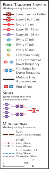 But to understand the maps, you must look at the legend. Our firm’s usual mapping style is dense with information, but therefore contains a couple of things that you need to learn. Most of the early expressions of panic and confusion have been based on misreadings of the map.
In our maps:
- Colour means frequency. Red means high frequency, and cooler colours mean lower.
- The colours mean midday frequency; see the frequency table for frequency at rush hour and other times, and see here [select Map 3] for peak-only routes that may be relevant to your area.
- Change in colour may not indicate that a route ends.It often means that the frequency changes but the route continues. Watch the route numbers to be clear, and remember, a spine like “A” is made up of Routes A1, A2, and so on, so where A1 becomes A, the bus keeps going.
A network redesign is both a big idea and 10,000 details. In recent presentations to the media and to local government councils, I focused on the big idea:
- more service …
- to more places …
- so that you get there sooner …
- with a little more interchanging (transferring in US parlance)
But of course the questions and objections were more about the details:
- How dare I take away my direct route to the city? Because it’s really infrequent and inefficient, and we can get you there sooner another way. If we give you more frequent service to a nearby hub, we can connect you to much faster service to the city, so in the end, counting waiting time, you get there sooner. We can also connect you to countless places you can’t get to now at all. In any case, only about 8% of riders all day, and 5% during the peak, lose direct service to the city centre, and not all of those people are going to the city centre!
- How can people change buses, or walk to a different stop in an intersection, when it’s windy and raining? The plan includes good shelter and attention to walking distances at every interchange point. But people change buses in more brutal climates than Ireland’s: Moscow and Edmonton come to mind. Most people have adapted to their climate. They know how to do things outdoors in it, and therefore can work with it when changing buses.
- How will this affect older people and people with disabilities? There is an unavoidable tension between senior and disabled needs – which are much more inconvenienced by interchange – and everyone else. A network designed solely around senior/disabled preferences for minimum walk and interchange is simply too slow to be useful for the rest of the population. Again, attention is being given to making interchanges as convenient as possible, including for people with limited mobility.
- Isn’t this connected to a lot of other things? How can you work on it in isolation? I address that one here.
Whether you live in Dublin or not, I hope you enjoy this work. The full report is the most advanced piece of work our firm has done yet. I can’t speak highly enough of the team at NTA, who have shown clarity and courage throughout this predictably difficult process.
If you do live in Dublin, you MUST complete an online survey. There is a link to it here. Yes, that’s a command. Too often, people take the attitude that public comment is just for show, and that the government is going to do what they want anyway. When that happens, people who like the plan take it for granted, and people who hate it feel like they have to scream to get their point through. So we get nothing but screaming, which makes the plan look like a failure.
On the survey, remember, we value specific comments. If you like the plan but object to a detail, say that. Don’t tell us that we’re stupid because we didn’t get your detail right. There are only so many details we can get right without consulting the public, so that’s the whole point of this public conversation.
That is an amazing before and after graphic. Did you have to sell your soul to Google Maps to get the data to build it?
I love the measure of “how many places can you get to within XXX time”.
Digging through the details, it looks like even evening/weekend service isn’t too bad, as long as your travel sticks to one of the 7 “spines”, which operate frequent service 7 days a week, 5 AM-midnight. To my surprise, the “frequent spines” are not simply stubs for people too lazy to walk to travel a few blocks downtown; they actually extend several miles in all directions, with branches extending an additional several miles.
The beautiful thing about them is that you don’t need to know or understand any fancy-pants network design theory to see that it’s a better bus system.
Are there isochrones for evening/weekend service? The appendix only has weekdays at noon.
We didn’t calculate evening and weekend isochrones this time around. I would expect the positive impacts to be even more positive, and significantly so, on weekday evenings; they would also be quite strong on Saturday midday. Saturday evenings and Sundays would show strong improvement near the spines, and more limited improvement elsewhere.
Hi Jarrett,
Great job!!!
Even if this plan is still under approval, can you tell us if there is a specific strategy regarding it’s “delivery”. Will it be all changes at the same time or not?
I recommend all at once, with a long lead time for preparation.
The A spine has a very serious flaw. In the south, the A1 and A2 have a common section, and the A3 and A4 have a common section. This means that, to get even 7.5 minute intervals to these sections, the order of the buses must be either A1-A3-A2-A4 or A1-A4-A2-A3, which in turn means that the A2/A4 common section in the north cannot get the 7.5 minute intervals you promised on the map. Please, correct this one before it is too late.
Consolidating radial services into spines is often a great idea, but in Dublin, I actually think the spines will become too frequent. In my experience, 8-12 minute daytime intervals are optimal. Higher frequency will often generate bunching, which is a waste of resources and leads to more congestion. A 5-minute route will in practice often have two buses every 10 minutes, so that it is no more useful than an ordinary 10-minute route. Much better to have two 10-minute routes so that you can get to more places whithout transferring. Also you will have less bunching when fewer people just take the bus which comes first.
I don’t know enough about Dublin to comment on whether features exist such as bus-only lanes or off-board fare payment to help mitigate the bus bunching.
When routes start running every 5 minutes or better, the dwell time a bus stops starts to become a lot more important than the wait time to get on the bus, so anything that can be done to speed up the bus ride helps immensely.
Tom. Your first parag is a good point, and we’ll think about that in the next revision.
We really want the feeling that the bus is always coming soon, and we don’t believe bunching ever a reason to run less frequency than the market can support. The plan is a big improvement in that it means the buses are not scheduled to bunch, as they are now. Obviously the bus lane project that follows will improve that further.
I will try to explain what I mean.
Take a look at the frequent route map for Gothenburg, routes 16, 18 and 19:
http://www.suniweb.se/wp-content/uploads/2012/06/Sparvagnskarta.pdf
(this is an old version but it shows the normal service pattern when there are no road works)
The 16 is scheduled to depart every 5 minutes much of the day. However, due to the bunching effect, late buses becomes more and more late and most of the time there are two buses directly after each other half-way along the route. This means that people travelling from the city center towards the northwestern part of the 16 effectively gets a 10 minute service.
The 18 and 19 are each scheduled to depart every 10 minutes during the day. People living in Backa thereby gets a 5 minute frequency. Since the 18 and 19 takes two different routes south of the city center, the 5 minute frequency is real, usually with no bunching. The people in Backa hereby have a better service than the people along the 16, even when their scheduled frequencies are the same.
In chapter 4, page 56, you say that “there is no way to extend it to the patterns crossing the city centre”. But this is not the case here! The 18 and 19 travels pretty close to each other in the south. In the nights, when each route only goes every 20-30 minutes, it is for many people quickest to take the first bus and take a short walk. This means that it’s actually very great to have the 18/19 with even intervals in the south.
Great work. Some minor quibbles:
1. Your recommendation that “Signage and information in this area should use a term like ‘all A buses,'” is a good idea at a high level, but needs to be supplanted by specific route call-outs. I guarantee that there will be customers who show up somehow thinking that “all A buses” is separate from the A2 route. Denver International Airport moved away from signing by Concourse “A, B, C” to signing by Gate “A1-A99” because people somehow needed reassurance that Gate A53 really was on the A Concourse.
2. What services will be provided in the off-off peak (before 5, 6, or 8 am and after midnight)? Surely if there is demand for buses every 3 minutes during the day there’s some demand for 30-60 minute headway overnight service.
1. Did you see the sample route sign in the summary report? This is exactly what we recommend.
2. For now the Nitelink service is unchanged, but obviously it should be reviewed to better match the new network.
We really need a better system. I have no idea how they’re going to fix it. I grew up on the bus system but a lot of my peers had long-held stigmas about it that meant they would never use it. It doesn’t cover enough commutes to be a go-to solution to recommend either.
The point being, how they’ll overwrite decades of reputation and actually get people on the bus is beyond me. It doesn’t really matter how good it is, they could make it free and most of the people I know still wouldn’t use it even when it would suit them. They need to overhaul it, then they need a marketing campaign.
This is easier than it sounds. When a bus network becomes more useful, more people use it.
I’m curious why the use of letters to designate spine routes (A; branches A1, A2 etc.) instead of the more traditional “route 1” for the trunk and 1A, 1B etc. for branches — reserving single-digit route numbers for the spine routes. (The numbering already follows something similar in assigning 3-digit numbers to lower-order routes.) Is this related to local context or is it intended to be strategic?
Reasonable people can disagree passionately about this, but we wanted a system where it’s easy to learn the pattern of the route numbers. The letters stand out from the numbers as indicating the most important routes that are useful to the most people and that tie the region together in a simple spiderweb grid structure. Hence A-G for spines and N, S, and W for north, south, and west orbitals.
Boom. Love this JWA. Amazing work! Frequency is freedom!
Was there a particular reason clondalkin train station wasn’t served by a bus service? The station is very under utilised and the road which passes it has a bus lane on either side of the road. All other stations on the same line seem to have bus routes feeding into them so just curious as to why it didn’t make sense to link clondalkin station to the bus network. Other then that fantastic plan can’t wait to see it implemented
Dean. You mean Clondalkin-Fonthill station? We’d have liked to, but in our discussions serving Neilstown properly ended up as the higher priority.
Basically, rail is mostly useful for travel to the City, and at Clondalkin we’re a little too close for the connection from a bus to an infrequent rail line to be a viable way of getting there. That’s why you’ll see much more focus on connections to commuter rail further out.
I did mean clondalkin foothill yes. It seams the station is fairly under utilised as traffic from the neilstown side towards town at peak times can be awful especially on the seconds from inchicore to st James hospital and I don’t think much more bus priory can be given along that route so I just figured a local service ever hour times to meet the train serving the hosing devopments in that area may improve people commute. Maybe even just a peak only feeder service as trains are a lot more frequent at peak and the area has no expresso service under the bus connect plan.
Just to clarify I’m in full support of the plan it’s just one little thing that stuck out as a missed opportunity especially if the bus was to link from say Liffey valley -neilstown- clondalkin/fonthill station- then a loop around bawnouge and cherrywood then back to Liffey valley. The locals in that area have been asking for a connect to Liffey valley for a few years now so providing this will kill two birds with the one stone and improve public perception of the plan which is currently being smeered by many local polititans and community groups in the area.
As a Dublin resident I am very interested in this plan. I’m willing to lose my direct route in exchange for a more useful system, that hopefully grows the users and improves more. But I’m worried about the strong objections we can expect to widening roads for bus lanes where they are badly needed.
I’m finding the isochrone screenshot above confusing. The isochrone suggests that it currently isn’t possible to get to from DCU to Swords in 45 minutes (or else it would show up red, as lost access). Google maps is telling me I can make that trip in 30-40 minutes at 10pm on a Thursday? Is it incorrect? How is the travel time calculated?
Is it true that the isochrones are calculated as the average time it would take you to travel if you just left now, and paid no attention to the timetable. Just waited for the next bus. Correct me if I’m wrong people in the know! So the isochrones shown are origin to destination, and include average wait time at first stop, travel time to interchange, average wait time at interchange stop, travel time to destination stop and then walk time from there.
I noticed what I thought was a mistake, whereas my own daily commute seemed to be becoming longer than currently, despite increased frequencies. But I live 12mins walk from the stop so wait until it is 14mins to the next bus before leaving the house for the every 20mins frequency 17a. I then only wait a minute or two at the stop.
In the new network, the bus is every 10mins, so I can leave at anytime and can expect to wait max 10mins once I get there.
Am I understanding this correctly?
Thanks.
Yes, average waiting time at the beginning of your trip — half the scheduled time between consecutive buses/trams/trains — is counted as part of travel time. The same calculation is made for any interchange your trip may require. Walking is counted as travel time too.
Thanks, appreciate that. When all this is implemented I look forward to playing “beat the isochrone”!
Kevin. Google shows you how long a trip takes starting when you get on the first bus. We calculate it based on any random time you might want to go. Thus, our travel time calculation includes the average waiting time for the first bus of your trip, which is half of the scheduled elapsed time between buses.
I’m a Master of Regional & Urban Planning student in University College Dublin, and I’m currently doing my thesis on this redesign and its impact on public transport accessibility across Dublin. I’m not copying your isochrone maps, but I’m looking more at accessibility to, rather than by, the public transport system, using a method based on Transport for London’s PTAL. I’ve been going through the proposals in a lot of detail (stop by stop), and I’m very impressed with them, particularly by how much it simplifies the network within the city centre. I’m still carrying out my analysis, so haven’t got any results yet, but I expect them to be very positive. I really look forward to seeing this being implemented, and I’ll definitely fill out that survey (and pass it on to others)!
I like the idea of using letters for the spines, it really makes them distinctive and stand out from the other routes. I’m not too keen on how the rest of the services are numbered though. The way each category of service has a different type of numbering system, it lacks consistency and makes them feel like separate networks, rather than components of the same integrated network. Also, some of the route numbers are already used in other parts of Ireland. Letters are already used for town services (e.g. A1 & A2 in Athlone, B1 in Balbriggan, C1 & C2 in Cavan, D1 in Drogheda), while the 200’s are used for Cork services (e.g. 201, 202) and the 300’s are used for Limerick services (e.g. 301, 302). With the intention to bring all public transport in Ireland under the Transport for Ireland brand, this could create confusion, as someone searching for a timetable could find two Transport for Ireland routes with the same number.
Thanks for your comments and your research interest in our work!
I don’t follow your concern about route numbering. This is Dublin’s network, so I don’t know why bus route numbers in distant cities are relevant. If you try to make every route number unique in the entire country, you end up with very high numbers that make the service look very complex. The goal is for this to be clear in Dublin.
The different kinds of numbers are contrasting to clarify their different roles in the network. Networks are made of different pieces playing different roles, so clarifying the roles helps make it clearer how the network works. An N number means a northern orbital, which is perpendicular to all the spines, so it will be easy to connect between an N line and an A-G line, but not so much to other N lines, which are parallel. Like any system you have to learn it, but then it’s useful to help ppl keep the structure in their minds.
Thanks Jarrett. In a large country, it might seem crazy alright trying to keep all routes unique. But Ireland isn’t a huge country and doesn’t have a particularly extensive public transport system, so keeping them unique is something we can easily do, well within 3 digit numbers. Our public transport is managed on a national rather than city level, and is intended to have a single Transport for Ireland branding, website and apps. So it’s not Dublin’s network, it’s Ireland’s network, and it’s always best to avoid duplication within the same network. If someone was to go onto the Transport for Ireland website or apps and search for a timetable or RTPI for a particular route, I think it would be confusing if there were multiple Transport for Ireland routes with the same route number, regardless of where they are.
It makes sense to differentiate between different categories of routes, but my only concern is that the more categories you have, the less distinct the differences are, and in this case there might be more than is necessary. The spines are clearly at the top of the hierarchy, and I like the idea of using the letters to make them distinct. But is there need to differentiate between orbitals, other radials and locals? To a transport planner, they might play very different roles, but to a user, they’re all very similar, each consisting of routes of varying frequencies. I’d feel that a good map (indicating frequencies) would be sufficient for people to see which routes are most useful for their particular journey.
I’d be more inclined to simplify the number of categories to just two – the high frequency Spines using the letters A to G (renumbering town services where necessary to avoid duplication), and all other routes, using the numbers 1 to 99. I’d avoid the 200’s and 300’s, as these ranges are well established in Cork and Limerick, and leave the 3 digit numbers for outside Dublin, and I’d just put an X at the end to indicate express routes, as currently done. This also makes it easy to tell people what routes are part of the network, i.e. city tickets and fares are valid on all routes A to G and 1 to 99. You mightn’t agree with me, but I’ll put together a good submission for the consultation and try my best to convince you anyway 🙂
Thanks for your views on this. As I said, there’s a lot of room for reasonable disagreement, but we’re confident that the approach we took maximizes legibility.
Like the new numbering overall, exept that the orbital routes seem a bit confusing….
N means north, S means south, W means west, and the numbers start at the city centre and go outward. Once you get used to it …
When one sees N1 for example, one would assune that its relationship to N2 N3 is similar to the relationship btw A1 and A2, which it is not
A fair point. I know I can never satisfy everyone with a numbering scheme. We will probably think about this some more.
Inaccurate to say that all current bus routes in Dublin are infrequent and inefficient, and given the surprising amount of 20+ minute frequencies in this plan (https://www.busconnects.ie/media/1256/proposed-service-hours-and-frequencies.pdf) also inaccurate to say the plan is improving on this across the board
Shows no understanding of why Irish people avoid transfer services like the plague which suggests it may suffer the same fate as previous efforts
I have no idea what you’re talking about. The number of people on <=10 minute all day frequency goes up 35% and the number of jobs and student enrolments goes up 18%. Please of all nationalities hate transferring when it involves fare penalties and long waits. They transfer more when those problems are addressed, as we do here.
The Irish experience of transfer services is that they are not reliable as the transport companies who provide the service will regularly modify the routes and services on the fly. This leads to missed connections, no connections and overcrowded buses. You can try to flood the route with buses to mitigate but it will not solve the underlying problem. I don’t want to be stuck in some transfer point trying to figure out how, when and if I’m going to get to my destination.
Same issue with the road management services, routes will be temporarily altered on a regular basis to facilitate road maintenance and events. A network that requires connecting services to function is going to fail regularly unless it addresses those pitfalls.
This is all before you consider how you sell a plan based on transferring to a public who have a very poor perception of bus services in general. Our bus company in Dublin made it into the top 10 of disliked brands NATIONWIDE a few years ago.
Andrew. Yes, but when we start working on fixing public transport systems, we are always in the situation you describe. There are always all kinds of trust issues, and issues with the incumbent operator. And we’re always told that all those things are reasons the plan is pointless, and that always turns out to be wrong. Each improvement we make strengthens the case for improving the other things, and gradually all aspects of the service get better.
One important thing that’s happening here is that NTA is gradually taking greater control over service design and quality assurance, which will give them the authority to correct some of the problems you’ve observed in the past.
The plan looks good, but I don’t like the non-clockface schedules for some routes (40 minute frequency).
What I like about this plan, is it looks like it is improving transit region wide, and has much more frequent service than you see in US bus network redesigns. There also appears to be less or no talk about ridership vs coverage. But instead, it looks like effort was put into making transit great throughout the region, instead of taking from one area to give to another, like is common in your US network redesigns.
I am guessing planning in Europe is different, where transit is seen as a benefit for everyone and not just the urban core.
Hopefully American transit networks can plan like this in the future.
Great work Jarrett. Very impressed by the plan. Will be filling out a positive survey. I have been following your work for years and always wondered what you would do with the Dublin network. Now I know!
Hello Jarrett. Thank you for doing this. Can I ask you in Dun Laoghaire why both routes 226/227 go cornelscourt to blackrock. And route 222/229 brides glen to Dun Laoghaire. Surely for both routes 1 should go to Dun Laoghaire and is 1 to blackrock. I Live along proposed route 227. We are part of Dun Laoghaire town yet we are being connected to blackrock. We should be connected to Dun Laoghaire and take over route 229 at monkstown farm. Our route was changed recently as part of route 63 and is working well. Yet you want to connect us to a different town. What was the logic.
Neil. Good comments. We can’t connect everyone to every centre, and we have two paths into Blackrock (Carysfort Av and Stradbrook Rd) that both needed to be covered. So that’s how the pieces seemed to fit together for us at the time. But feel free to comment on this using the survey at busconnects.ie. Tell us what, in your view, should serve Stradbrook Rd and Carysfort Av instead. J
Why is nobody asking what will happen to the inner city when all these buses are routed through the SPINES/Corridors, where they will be given priority at the expense of Bikes and Cars. Lower Kimmage road for example will have buses only from the KCR right into town and the cycle route will be rerouted through nearby estates. This is because this road is too Narrow to take any more than two lanes of traffic. how does this work for other road users who are not taking the bus? Seems that the spinies are bulldozing through historic communities and neighborhoods for the 3-4 hours a day when rush hour traffic is a problem. WHy not design a Metro System that every other major city in the world has built as the solution to getting around their City.
Overall volumes of buses through the city don’t go up under the plan, because the spines replace many overlapping bus routes that deliver similar buses/hour today. In fact, they go down in some cases, which has been one cause of concern. You will get to debate this with your neighbors!