 The massive redesign of Houston’s bus system, which has helped grow ridership as many US transit agencies are losing riders, would not have happened without Christof Spieler. Within the Houston METRO Board, he was the one member who rode transit, thought constantly about transit, brought professional credentials as an urban planner, knew what needed to be done, and knew how to argue for it to people of many different ideologies and cultural backgrounds. The Board, which was itself ideologically and culturally diverse, was inevitably guided in part by his expertise, passion, and patient persistence.
Since then, Christof has been traveling the US, studying and thinking about transit. Every week, it has seemed, he tweets from some new city. Finally, all that thinking has come together as Trains, Buses, People: An Opinionated Atlas of US Transit.
The first two parts of the book are a sensible explanation of what good transit planning is: Think about people rather than technologies. Think about networks rather than lines or corridor projects. Think about frequency rather than just speed. These are arranged in simple one-topic pages, with a summary paragraph and bullet points — ideal for skimming.

Christof’s map of Los Angeles. Note what a small area has frequent service both north-south and east-west. (Orange lines are frequent buses, and all rail is frequent except the purple commuter rail lines.) (Island Press, 2018)
But it’s the third part, the atlas, that will really suck you in. For the 50 largest metro areas in the US that have rail or Bus Rapid Transit (that’s everything bigger than Fort Collins, Colorado or Eugene, Oregon) he provides a loving description of the city’s network, its demand pattern, its recent history, and its issues. Denizens of each city may disagree with what Spieler chooses to emphasize, but he certainly will start a lively conversation, not just within cities but about the comparisons between them.
What’s new about this atlas? Spieler shows you the frequent bus network for every city, thus helping you see not just where trains go, but where people can go easily.
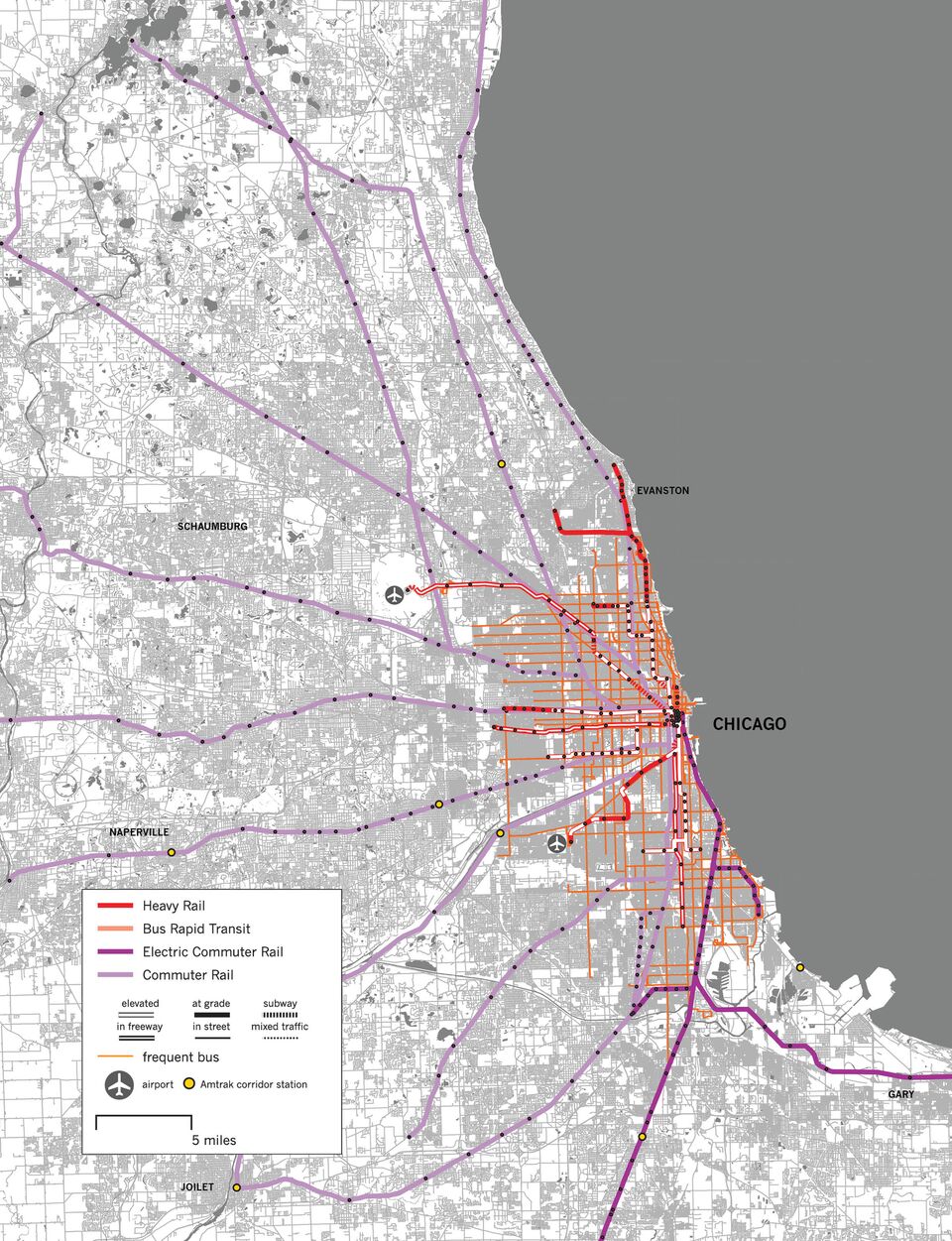
Christof’s map of Chicago at the same scale. Note the substantially larger area with both north-south and east-west frequent lines. (Island Press, 2018.)
For example, his Los Angeles map reveals that despite the vast area of moderate density in that city, a complete frequent grid (with both north-south and east-west lines near most people) exists only in a tiny area of about 7 x 7 miles (the size of San Francisco), extending roughly from downtown to the edge of Beverly Hills and from the Hollywood Hills to just south of I-10. Everything else, including highrise centers like Century City, Burbank, Glendale, and Pasadena as well as vast areas of mostly 2-3 story housing, has frequent service in only one direction, if at all. Another map of Los Angeles includes densities, and shows how much high-density area lies outside the frequent network entirely.
Spieler’s map of Chicago, by contrast, shows a remarkably complete grid over very similar densities in a city with even fewer major destinations outside of downtown.
Spieler’s book is perfectly designed to be both readable and browsable — a great gift for an urbanist or transport geek and a great book for the coffee table. You can read around in for a long time, exploring different cities, their strengths and their missed opportunities. Let’s hope it produces a smarter conversation about urban transit.
Christof Spieler: Trains, Buses, People: An Opinionated Atlas of US Transit: Island Press, 2018
Comments are closed.