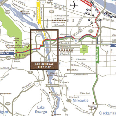
That red line (and the adjacent blue line that’s hard to see) is the east-west spine of Portland’s transit system. On the west, it is one of just two direct paths (street or transit) across the hills linking downtown and the the “Silicon Forest” suburbs to the west. But the slow operations across downtown makes this line much less useful than it looks. Credit: Travel Portland.
In 1986, Portland opened one of the first modern light rail lines in the US, the beginning of a light rail renaissance that built networks in mid-sized cities across the country. It was nice to be a leader — we’re used to that in Portland — but it also means that everyone has learned from our mistakes, while Portland still has to live with them.
Perhaps “mistake” is too strong a word, but the priorities of the early light rail designers certainly aren’t the priorities today. Planners of the 1970s (when I was an enthusiastic teenage transit geek) confronted a city whose downtown consisted mostly of surface parking while prosperity fled to the suburbs. Their top priority wasn’t even getting people to downtown. It was making downtown a place worth going.
So they built a line that rushes into the city from the eastern suburbs, but then creeps across the inner city, making lots of stops for a net speed under 7 miles/hour. For a while that was fine. All those stations meant lots of development sites right next to the line, and downtown grew and prospered.
Today, the success at revitalizing downtown has created an opposite set of problems. Downtown and the surrounding neighborhoods are so successful that working people can’t afford to live there. Low income people are being pushed out to places where they face longer commutes. Most important, the line now continues west out of downtown to serve the “Silicon Forest” suburbs to the west, so that it runs across downtown, not just into it. Meanwhile, the development that the slow downtown segment was supposed to stimulate is largely done.
So the downtown segment of the line is becoming more of a barrier than a resource.
Transit in Portland benefits enormously from chokepoint geography. Between the inner city and the western suburbs, there is a wall of hills pierced by one gridlocked freeway, one parallel arterial, and a light rail line. This rail segment has prospered because the driving alternatives are terrible.
As always, chokepoint geography means: It’s worth spending a lot of money improving transit here, because so many trips, between so many places, go through this point. A regional inbalance of jobs and housing (more jobs in the west, more housing in the east) has create a huge east-west travel demand right through this ch0kepoint. The hills are still a barrier for drivers, but for transit the barrier is the slow downtown streets, and the 1970s assumption that the train needs to stop near every building.
As if the slow operations weren’t bad enough, there’s also a problem of capacity. Portland’s adorable little 200-foot blocks, rightly credited with giving downtown such a human scale, limit the train lengths to 2 cars as long as they run on the surface. The city is too big now, and its transit needs too dire, for such tiny trains to do the job.
The problem is being attacked at several scales. The transit agency is gingerly suggesting that a few stations should be closed. Stations on the downtown segment are as close as 350 feet — far too close for bus stops, let alone rail stations. (The newer north-south light rail line, whose designers learned from the mistake, has station spacing closer to 1000 feet. Unfortunately, it is the east-west line that extends furthest into the suburbs and therefore serves the most people.)
But the problem is so big, and obstructs so much access to opportunity across the region, that it won’t be solved just with half measures. A long overdue study is looking at the complex of capacity problems, and while it’s looked at some half-measures, the only thing that solves all the problems is a new segment of subway under the core. The long frequent east-west lines serving suburbs (and the airport) would go into a tunnel, rushing under downtown in perhaps 1/3 the time, so that transit would finally be viable for travel across downtown and not just to it. The existing surface line would still be used to provide a more local service across downtown.
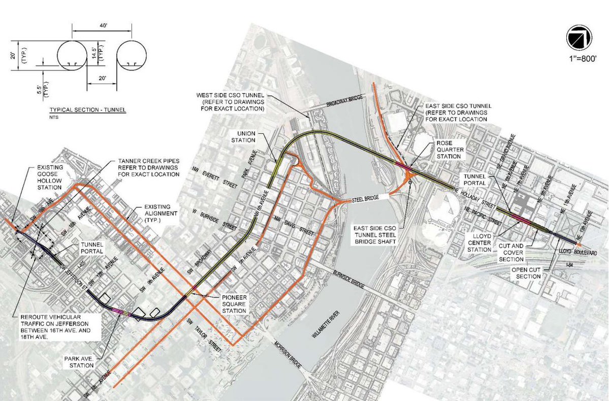
An early concept for the downtown rail tunnel (black) with existing light rail segments in red. The tunnel has six stations counting the endpoints. Too many?
I have been skeptical of many rail projects in my time, but the most defensible of all are these “core capacity” projects. Like the excellent Los Angeles Regional Connector, this is a project that is in downtown but not for downtown. Its purpose is to unlock the potential for all kinds of access across the region. To bypass the inevitable edge-core debate, it will have to be presented in those terms.
That’s why I’m a little skeptical of the earliest concepts. As sketched the tunnel has six stations downtown. They should at least study a line that just has three: the two edges of downtown — Lloyd Center and Goose Hollow — where the fast line would connect with the slow surface line, and just one station at the very center of the city, Pioneer Courthouse Square, where almost all of they city’s radial transit services meet. This would make the new line barely half as long and much less expensive.
Obviously there are great arguments for every proposed downtown station: the university, the stadium, the train station. But it’s going to be important to have clear conversations about the balance between downtown and regional benefit, and between the benefits to an already prosperous downtown and the need for reasonable travel times for low income people, who are increasingly pushed further out where they have to travel further.
I don’t know that a three-station solution is right, but I know it should be looked at. It’s really easy to get around downtown on transit, from anywhere to one of the three stations that this minimal version would offer. It’s really hard to get across the region, and every station we add to this project moves us back toward not solving that problem — not just by making the line slower but also by making it more expensive. It’s a tough balance, and I hope we’ll have the debate.
I’m really going to be honest here; We need to be talking about developing new core urban centers outside of downtown. I get wha you are saying about network dynamics but you don’t address the critical issue: there are other urban centers across the region that we could be increasing densities. I’d rather not dig up downtown and instead spend it at new urban cores like Killingsworth, Vancouver, Gresham, Tigard and Hillsboro. Downtown is stuffed to the brim with success, so let’s evolve network planning, which means redistributing the main origins and destinations to other more equitable and lower cost real estate locations. That’s the core debate in NZ you seem to be loosing track of; the strength of their non-urban growth centers. Plus EQUITY… downtown had its chance let’s try these concepts in less expensive places.
The thing with developing new core urban centers outside Downtown is that is just means even more travel through Downtown, making the subway that much more important. Employers want access to the whole regional pool of employees, employees want access to the whole regional job market. Particularly in a world of two-income households, people aren’t just going to be able to sort themselves by where their jobs are located. Which is really just the point that Jarrett was trying to make above.
If a sprawled out metropolis could create a lot of bus lanes and fill in land with several dense downtowns, it really could change transit. It would be neat to be able to walk to one center hub, and catch an express bus to another center hub, taking bus lanes and bypassing traffic, with minimal bus stops.
However, this would take a drastic change in infrastructure and I highly doubt we will see any of this anytime soon without a massive spike in population densities.
Also, I wish that cities would allocate road space by trips per person instead of vehicles. The only thing that keeps me from taking transit is time. I don’t care about the mode, wifi, amenities, or any of that stuff. It takes three-four times as long to get to my destination via transit than car, so transit is a no-go.
Portland has a pretty abysmal record at creating new urban centers. The great places in Portland were built 100 years ago. The urban centers designated in the 2040 plan like Tigard and Gateway are still pretty miserable places. Until the planners figure out open spaces and parks, few people are going to want to spend waking moments in these places.
Let’s not overlook how multiple urban centers would MASSIVELY change the complexity of the transit system, it’s accessibility and efficiency. You’d be moving away from a variation on a hub and spoke model to a point-to-point model, which are much more complex and expensive. People love our system for its design and efficiency (regardless of the truths involved), and I personally don’t think Portland is s great candidate for this type of growth.
Portland’s downtown is not filled. Chicago’s Loop is about a third bigger than Portland’s and has over 390k jobs, while Portland has 78k jobs downtown. This means plenty more job concentration still is possible in Portland.
I’d also argue that it’s desirable based on these grounds. First the transit network as it stands is highly radial, and thus maximizing job access for all residents means putting jobs at or near the center of the network. Second, as Alon Levy has repeatedly observed a transit city is a highly centralized city. due to the dynamics of what makes transit efficient and what makes cars inefficient, meaning job dispersal leads to higher auto mode share, and poorer auto access for those jobs.
Anyways Portland should build this tunnel and more skyscrapers in the center.
https://pedestrianobservations.com/2011/11/21/a-transit-city-is-a-centralized-city/
Portland’s street grid is not suited to Chicago skyscrapers. Blocks are too small.
Jarrett, I agree. I also would argue that we should not be hyper focused on building high rises in most areas. Because the shaking from a Cascadia slip would last 4-5 minutes, widespread building failure is a possibility; science just doesn’t know how this prolonged shaking affects high rises. I realize this is highly controversial, and it’s just my opinion and I leave equal room for other alternatives.
People need to get through the center to your beefed-up urban centers, so the tunnel actually benefits your goal. Seattle has a similar issue: the region explicitly targets future growth to a dozen edge cities like you’re suggesting (even though greater downtown is actually growing faster), and it decided a second downtown metro tunnel is necessary for both downtown circulation and to get people across the isthmus between the north end, south end, and Eastside. Both the north and south outlying counties want to attract more jobs and workers and think people will reverse-commute even from the other side of the isthmus. Portland could have a similar win-win-win effect, with increasing jobs and mobility in both downtown and your outlying centers and busy trains both directions all day.
(There’s some doubt in Seattle about whether the outlying cities can really attract so many jobs, but they’re a lot further out than Porland’s. Everyone agrees the area within Lynnwood, Redmond, and Federal Way is solidly ready for larger urban centers and high-capacity transit, and Hillsboro to Gresham to somewhere south is in a similar situation.)
Also, Seattle has “subarea equity”, which means that the north, south, east, and city subareas each have to pay for their own extensions out of their own taxes — there’s no cross-subsidy (in theory). But the second downtown tunnel was seen as benefiting all subareas because it does, and so they’re charged for their percentage of trains in both tunnels. Portland probably doesn’t have this funding situation — usually it’s just one regionwide tax base with central control — but it reinforces the idea that a downtown tunnel benefits all areas.
Is it any surprise that Jarrett supports the same three-station concept from the 2009 HCT System Plan, the one that he studied while he was an employee at Nelson Nygaard?
Isn’t one of the objectives of a tunnel to serve dense activity centers in Central City, not just create the fastest possible trip through downtown? Don’t we want to serve existing (+future) households and jobs while increasing transit reliability through grade separation?
For example, the Pearl District has over 7,000 residents, 15,000 jobs, 2,000 affordable housing units (many clustered in the north end where existing transit service is not adequate), and massive development potential at the Post Office site. Why should it be bypassed by MAX regional rail for a third time?
I think Jarrett’s idea is to use the existing surface trains to access activity centers, and use the tunnel as an “express” to bypass them.
Actually, I left NN in 2005, before that plan was done.
As Jarrett said, those dense areas can be served by the existing lines. Changing from a fast cross-town line to the surface network might actually mean faster journey times overall. It works this way in my home of Paris, where RER trains from the suburbs connect with the inner-city metro. If the RER stopped as often as the metro it would defeat its whole purpose as a rapid system.
This suggestion might work in the abstract, but what many here (including Jarrett) seem to not understand is that Portland lacks the political will to create reliable surface transit. Congestion is a growing problem in the core and will continue to get worse. Even the “dedicated” MAX right-of-way is routinely delayed by pre-emption signal issues and blockages caused by crashes, cross-traffic, protests, or whatever else. The Streetcar is even worse in this regard, except it can’t even get true transit priority in all but token stretches where we have installed a BAT lane (that is often ignored). And yet it still is one of the highest ridership lines in the city because of the dense activity centers it serves: Northwest, Pearl, West End, PSU, South Waterfront.
The tunnel is a once-in-a-generation opportunity to improve regional transit access to many of these locations and we shouldn’t dismiss its potential so quickly.
And btw, I still miss Portland Transport dearly for these discussions. Chris I and Richard Bullington/Anandakos will concur.
of course, Paris is much bigger, but there are both kind of underground networks : “métro”, linking every bit of the city, and “RER”, which goes through the city with a minimal amount of stops at strategic location.
What makes the whole thing work properly is the high level of interconnection between both. Suburbanites go in the area they want through RER, and go to the specific part they want through Métro. As I understand the plan, the surface network – that serves all those tiny places downtown – would be connected to the rest. Giving both a local service and a regional service; both being important, yet serving different purposes.
There needn’t be “one ring to serve them all.” The street car, buses and more local light rail can provide those local links.
I completely agree with the analysis that the MAX is far too slow through the Central City, and that severely limits how useful it is for cross-regional trips. A tunnel is the only way that we can increase the frequency, speed and capacity of trains, all of which are limited by the Steel Bridge bottleneck and/or the short length of our downtown blocks.
Any tunnel will need to have fewer stations than we have today, or even than we will have once TriMet closes some of the original stations. It would be a mistake to place too many stations on the route… but it would also be a mistake to place too many. The proposed Union Station stop would be approximately 3,300 ft north of Pioneer Courthouse Sq; a larger stop spacing than BART in the Market St tunnel or LINK in the Downtown Seattle Transit Tunnel, both of which are also at the center of regional rail networks. Similarly, the two Lloyd District stations are approximately 2,300 ft apart, which is close to the spacing of BART in the Market St tunnel.
The Lloyd District and the Pearl have seem enormous amounts of housing and job growth in recent decades, and are planned to have more. I don’t think that serving them adequately has to compromise the project goal of speeding up the MAX through the core.
*also be a mistake to place too few.
Dang it.
I knew what you meant 🙂
I also agree with your points.
I agree entirely with maccoinnich. I’ll also say a few other things:
— The Union Station subway stop should really be moved further north, preferably actually with an entrance inside Union Station. Ideally with a second exit on the “Yards at Union Station” side.
–The Rose Quarter station should be directly under the freeway, with exits to both the east and west sides, so that nobody has to walk under the freeway on the surface to get to it. The proposed location wastes the west exit.
— The Lloyd Center station sohuld be further east, but this may be impossible due to the location of the light rail bridges over Lloyd Boulevard.
— Infill stop near NE 28th makes sense.
— There needs to be a serious plan for what to do with the surface route. It’s still needed, but would have a cascading effect on MAX reliability if used for any MAX route at all. Convert to Streetcar?
Wait a minute! Wouldn’t San Diego’s 1981 opening be considered the first modern LRT in the U.S.?
The block length issue has an interesting sidebar. Don McDonald, the Edmonton engineer who also led Tri-Met’s project, hoped that the reliable Siemens-DuWag Frankfurt car selected by Edmonton, Calgary and San Diego would also win the Portland contract. Don was too ethical, however, and the process allowed for a variety of cars to be considered. Bombardier came in with a winning design from Belgian carbuilder BN that was longer than the SD car. And as it turned out, a two-car BN train fit a downtown block. It would have taken 2½ of the SD cars to do the same thing.
Don adjusted to his disappointment, noting that “the Bombardier bid was low enough that I could afford to send someone to their factory to keep an eye on things.” It might seem odd to younger readers, but this was after a decade of equipment fiascos in the U.S. A new system starting out with a new car design was scary.
I won’t try to settle the subway issue from out of town, but I know the Steel Bridge well and an alternative needs to be underway before there is a serious problem.
You got me on San Diego. I’ve revised the text.
Here in Osaka I never really thought about how far apart the metro stops are because walking from one stop to another never really seems like a big deal (e.g. if I want to enjoy the weather instead of taking the train).
So I measured on Google Maps. The distance between most stations? 500m minimum, but more often 800-1000m — that’s in the center of the city. And in reality, if you’re taking the train to your destination the theoretical maximum walking distance is half the station spacing.
You are definitely correct Jarrett — 1000 FEET (300m) spacing is way TOO CLOSE. Especially with “downtown” being 2,000m across at most? So if you have stops on the very edges of downtown, you really only need a single stop in the middle. That puts everything within a 15 min walk at most (at a very casual pace) if you look at the walk radius between stations and consider that most of the time you won’t be walking to the far reaches of the radius anyway.
Add to that the high percentage of bicycle ridership and the excellent bus system in Portland and there’s really no legit reason to put train stations so close together. Use trains for what they’re good for — distances that are too uncomfortable for most people to walk, and which need more capacity than bus — and let the other modes fill in the gaps.
I hope they listen to you.
I’m guessing that was between Matsuyamachi and Tani-yon? I’ve spent a lot of time around that area, and those two stations do seem oddly close. The local neighborhood association probably lobbied hard for the former when the Nagahori-Ryokuchi Line was built.
As for Portland, I agree that six stations is too many. But in addition to the stations Jarrett suggests, I would also keep Union Station if for nothing other than connectivity to Amtrak and commuter rail.
“I would also keep Union Station if for nothing other than connectivity to Amtrak and commuter rail.”
Even though there are only like a dozen or so departures a day on Amtrak from Union Station to connect to from the LRT, and no commuter rail at all there? A hundred or more other LRT trips every day would be stopping there to connect to nothing.
The Union Station stop would pick up ridership from the Pearl District, and several other large upcoming developments in the immediate area. The Post Office site is about to be developed into thousands of units of housing and quite a bit of commercial as well.
From a ridership perspective it makes a lot more sense to have this station west of Broadway within the post office site. At the very least, the station should be directly beneath Broadway with station entrances on both sides of the street. It may even be worth looking at an east-west oriented station straddling Broadway that’s suitable for four-car trains. The western exit would be somewhere near the Park Blocks and the eastern exit close to Union Station.
The more I look at it, the more I think an alignment under Broadway makes the most sense. Lengthen the platform at Lloyd Center (and possibly widen to make 4-track with center platforms for transfers), then dive down and run cut/cover until it turns to a bored tunnel before a deeper Rose Quarter station. Cross the river in an arc and have a station under the Broadway ramp just west of Union station. Continue south and serve Pioneer square on Broadway (still offers quick transfers to MAX/Bus on 5th/6th). Then make your arcing turn west and emerge for another surface transfer stop at Goose Hollow. This would be a total of 3 underground stations, which I feel balances speed and transfer options. Skipping a stop at Union Station/Pearl would be a mistake.
A well-planned Union Station stop would have an exit inside Union Station — and yes, there’s enough people coming in on Cascades and the Coast Starlight to make this worthwhile — and an exit on the east side of the tracks in the otherwise-isolated “Yards at Union Station” waterfront district.
The Rose Quarter stop on the east side of the river should have an exit west of I-5 and an exit east of I-5; it’s currently located too far west.
The Portland Art Museum stop may seem exceesive, but it isn’t, and again the reason is an expressway: I-405. If I-405 were filled in, it would be excessive, but with it acting as a barrier to walking, people will hop the subway just to get across the expressway.
I’m thinking about what to do with the old line. It’s trying to do three things at once, all badly. It’s a north-south line down the waterfront (which only goes halfway, and misses Union Station). It’s an east-west crosstown line (which is too short and doesn’t go on the east side of the river). And it’s a north-south line west of I-405 (which is much too short). All of them are at “Streetcar” spacing so should probably be converted to “Portland Streetcar”.
Perhaps what makes the most sense for the short term isn’t obvious. Once there’s an underground Union Station stop and an underground Rose Quarter stop, you could run the Yellow Line on it — passengers for Union Station could change at the Rose Quarter.
In the longer run, however, the remaining line should be divided in two where it turns from First Avenue onto Morrison & Yamhill.
The Morrison & Yamhill line should cross the river on the Morrison Bridge or a new adjacent bridge (or tunnel), and run on Belmont all the way to I-205, taking over the #15 bus.
The Chinatown line should continue south to Harrison Street.
I found Japan a bit of an eye opener in terms of how the rail system has developed as a patchwork of different companies. Clean – yes, punctual – yes, integrated – hit and miss with stations on adjacent lines constructed some distance apart where they could have formed an integrated hub with centralised planning. Apparently the “Act on Enhancement of Convenience of Urban Railways” aims to mitigate this by building connecting routes where feasible in Tokyo, Osaka and Nagoya areas.
As regards Portland or anywhere else, the walk from commuter rail to light rail needs to be short, well signposted and preferably under cover otherwise you can’t reasonably expect people to use it with other options.
I spent 7 days on Japanese public transit. I was five months pregnant and determined to walk the Tokyo fish market. No regrets but they did close it to the public. The walk in terminal large frozen tunas, five months pregnant. Did I already say that. We tried to find rush hour trains to crash. It was amazing. Different geography but dam the intensity of super stacked train stations I will never forget.
A three-station plan seems too sparse. In the plan you cite, Park Hill and Pioneer Square are definitely too close together. Pioneer Square enables transfers to the surface lines, so Park Hill has got to go. But I’m much more wary of eliminating the stop at Union Station.
At the very least the tunnel should be built with provisions to retrofit a station there. The mainline rail station isn’t going to move, and any future transit lines that leverage Portland’s freight rail lines *will* want transfers to the subway. Adding the stop later will cost orders of magnitude more than building it now, so it seems a relatively low-cost hedge against any future S-bahn-type service.
This article seems a bit vague. It isn’t clear how much time it would save to skip the two stops, or for that matter, how much time the tunnel will save. Let me take a stab at it:
According to Google, it takes 17 minutes to get from one end of downtown to the other. If it takes 1/3 the time, that is roughly 6 minutes. That seems about right.
Skipping three stops is mostly about avoiding dwell time. Assuming 30 seconds per stop (which is likely a bit generous) that is 90 seconds. Acceleration/deceleration adds some time, but not much, since the distances are short anyway (even with three stops a train won’t reach maximum speed). So add 30 seconds (again, likely a big generous).
So basically you are talking about saving a couple minutes. You go from 17 minutes, to 6 minutes, to 4 minutes. That seems like a heavy price for those last 2 minutes. An 11 minute savings is huge; a two minute savings — not so much.
Meanwhile, you give up a lot. Again, it isn’t clear what the plan is in terms if mixing the trains. You have the “local” (that runs on the surface) and the “express” (that runs underground). Is the idea to have half local, half express on each line? Or is it to favor the express, since that is where the city is investing? If you skip the stops, then the latter is difficult. Demand would be higher for the train “that makes all the stops”. An express is cheaper to run, since it completes its run faster. If you are running lots of locals, then this costs the agency money.
Meanwhile, one of the stated purposes of this project is to deal with crowding. The local trains can only serve so many people. Because the two trains share the same track, this will actually reduce the number of local trains that can be run. If half the trains are local, and have express, the assumption is that lots of people will switch to the express. But if people prefer the local train then it will be more crowded than when you started. It makes sense to move as many people to the express as possible, since it will have a lot more capacity. The best way to do that is to have all the stops.
This seems to assume that cross town traffic exceeds demand within the city, but again, I don’t see any data for that. I would also be very surprised if that is the long term trend. If Portland grows, it is likely to grow right in the heart of the city (the way most coastal cities have grown recently).
The only argument for a stop diet that makes a lot of sense to me is cost. As Jacob said above, if that is really an issue, then the thing to do is allow the stations to be retrofitted. Very rarely (if ever) does an agency regret putting in a downtown station. But they certainly regret leaving one out (e. g. First Hill in Seattle).
From what I remember of the VTA analysis of the now discontinued express trips on the Santa Teresa Line, the time it took to stop (including doors opening, people get on and off, and acceleration/deceleration so the whole deal) was 40 seconds per stop. Not sure if that applies here neccesarily but it gives you a more concrete starting point
It’s not crosstown trips vs downtown trips, but crosstown trips plus Pioneer Square trips and all the transfers there and Lloyd Center-Pioneer Square trips and Lloyd Center-Goose Hollow trips vs the other downtown stations. The remaining surface trains function like the streetcar lines, so the question is whether any of its unique stations are so important they should be added to the express line. The current service is *really* slow because of both the Steel Bridge and so many stations — this solves the two biggest problems and still gives access to a lot of downtown. If Ben is right and it’s a 15-minute walk between the stations, then the longest walk is 7.5 minutes, which is borderline reasonable. It should ideally be 5 minutes and that would serve more of the triangle area outside the walk circles, but it’s close, and there are the surface trains for other parts. I could even see the surface segment turned into a shuttle. That seems better in some ways, and it would allow the metro lines and the shuttle line to independently have their own optimal frequencies rather than a compromise.
“Very rarely (if ever) does an agency regret putting in a downtown station.”
I get that most cities (including Portland) aren’t anywhere near as densely developed, but the many abandoned downtown stations in Manhattan, London, Paris, etc. would beg to disagree with the idea that “rarely does an agency regret putting in a downtown station.” Sometimes, a downtown station becomes inconvenient to serve for a variety of reasons, and must be closed or severely curtailed in service even despite high passenger demand.
There are very few abandoned stations in Manhattan and London. Usually in Manhattan, a station was abandoned when the trains got so long that, with platform extensions, two stations bumped into each other. Same in London.
Don’t know Paris that well. Chicago closed a bunch of stations, but then reopened nearly all of them.
Twelve-car trains won’t happen in Portland, and all six stations are desirable. What is perhaps not obvious is that the full six-station plan, including Park Ave., allows the truncation of a whole bunch of bus lines coming from the east including the #6, so that they don’t have to cross I-405; a substantial time and reliability savings.
The Union Station stop really should be built but should be further north, under Union Station itself.
I’m inclined to agree that three stops is too few. It would be hard to eliminate the Rose Quarter station given its importance for bus transfers (though not having a stop there would justify doubling frequencies on the Yellow-Orange Line). Park Ave would presumably be comparatively cheap given that it would be build on open land, and would presumably generate a lot of trips due to its useful proximity to PSU.
Finally, I am not sure that the real utility of the tunnel would be for travel from eastern homes to western places of employment. Land use in Washington County is pretty abysmal. OTOH, people who live to the west and who work in the Lloyd would be huge beneficiaries of this plan–whether it involved six stops or three.
This concept map looks like it has 2-car length stations. Metro mentioned 4-car stations in the materials they released. That raises a lot of questions about how the stations are configured — both new and existing.
Existing stations have to be 2-car length due to existing geography – Downtown Portland blocks can’t accommodate anything bigger without blocking traffic.
All of the stations outside of downtown can be lengthened to accept 4-car trains. Some will be more difficult than other (Washington Park, Gateway, etc). I think the issue he is raising is that the concept picture above isn’t showing platforms long enough to accept 4-car trains. If you drew it with the lengthened platforms, the stops would be even closer together.
Yeah, that is a little odd. Well, here’s some points as to how to do it:
(1) Expand Goose Hollow station platforms to the WEST (and move the whole station west if you have to)
(2) Expand Park Avenue station platforms on both ends.
(3) Expand Pioneer Square station platform to the NORTH.
(4) Expand Union Station platform to the NORTH (the whole station belongs further north), and move the curve under the river if necessary.
(5) Expand Rose Quarter platform to the EAST (the whole station needs to be moved east too)
(6) Expand Lloyd Center platform to the EAST (the whole station needs to be moved east too)
Once you do this, the spacing becomes reasonable.
The tunnel should “belly out” to the north to about the grain elevator just north of Broadway. This allows a much shallower and more useful station at Rose Quarter and placement of the “Union Station” station at about 9th and Marshall. This puts it adjacent to Union Station using the underpass under the Broadway Bridge approaches and very close to the large new buildings in the North Pearl. Have another station at 8th and Couch for the southern Pearl, and the Pioneer Square, Park Avenue and Goose Hollow stations as shown. Yes, this is one MORE stop, but it means the tunnel serves all of downtown Portland.
Park Avenue is very important because it means that riders from the Northeast lines can transfer to the Orange Line (or for that matter to the Green Line extension) AFTER the slow meander around Union Station and down the Transit Mall. Riders from the west wouldn’t have to “double back” to Pioneer Square, and those from the Orange Line could transfer to the high speed line at the third stop downtown.
All of the stations on the main trunk — :PDX to Elmonica — will have to be lengthened to four cars to make this work. It’s probably not possible to do that for the Blue Line east of Gateway, so the Green Line will have to become the four-car train partner of the Red Line. That’s a shame because there are a LOT of apartments which have grown up along the Blue Line that will lose their service to the west end, but I really can’t see how you’d provide four-car stations down Burnside.
You could definitely lengthen platforms east of Gateway. Due to the offset nature of the surface stations along Burnside, all it takes is a bit of widening along Burnside, and minor track re-alignments. We’re only talking about 4ft of width needed here.
I just realized that the Blue Line could become the “Local” line preserving service from East Portland to the West End, though without the express speed-up.
The catchment for each underground station can be extended by an entrance at each end of the platform. If the subway stations are built for 4-car trains, the entrances could be 120 m apart and capable of serving several connection points. There can also be underground pedestrian tunnels to extend to radius of pedestrian access within a 5 minute walk. I recently spent time in Sapporo, Japan, where there are over 4 km of underground pedestrian tunnels serving multiple subway stations.
You guys missed it: C-Tran just signed an inter governmental agreement with WashDOT. Sometimes the only solution is the only one that will be at downtown PDX by next year. BRT lanes over the CRC. Jarret you always said BRT’s are emergency responses to bottlenecks. Well now that we have to do Trunnion Repairs on the old one we don’t have a choice. BUS and FREIGHT lane coming it you from the North. Sometimes you just have to bend over the river take what you can get.
Two questions come to mind: 1) How many people commute across the region? and 2) Is downtown service good enough that people could get off at the central station and take another bus or train to more local stations?
So, I will say at the outset that I have taken Portland Mass transit for 25 plus years. I don’t drive. I sometimes get rides from people, but that’s about it as far as me and cars go. I feel like a great deal of the discourse above is not grounded in the reality of the transit rider. Here are my thoughts:
a) I rarely want to get from Eastside to Beaverton and beyond. I agree that sometimes I feel like my life is spent in eternal hell just getting out of downtown on MAX, but that’s the problem: I want to get out of downtown faster than I can or I want to get from one end of downtown to another faster than I can. I would want to see solid research on numbers of people who start off at say, Rose Quarter or further East and still are riding by Goose Hollow and beyond. And speaking of the Chicago system. Is it possible to go up and not under the city? I have always wanted a MAX train that skipped from Rose Quarter to say … Pioneer square.
b) Anytime I have to get off a train or bus and wait downtown for another one — I risk wasting 20 minutes easily. For example, the number of people who walk or run from the Green line over to the Yellow Line at Rose Quarter is substantial. I have to get off, walk a ways, get rained on and wait … usually at least 10 minutes in nasty weather. Can we imagine a transit system where connections were made easier or … where one could stay on the same bus/train? Why does every MAX Line from the East side have to go over the bridge?
c) I think rather than quibbling over six or three stops in some massively expensive underground system, we might think about smaller changes that would really make a huge difference to commuters or riders. For example, as one person at least notes above … it is a pain to get out of the Pearl. I can’t tell you the number of times I’ve literally run to make it out of the Pearl to some form of viable transit. (The Streetcars are a joke.) Why not do a comprehensive analysis of the sore points for transit riders across Portland and work seriously on improving those?
d) Recent changes in “safety” on MAX have helped. For years, I tended to opt for buses over MAX, because the bus driver in theory had some level of control on what went on in the bus, whereas the MAX car used to be like the Wild West. Anything and everything used to go on in those cars, and mostly I didn’t want to subject myself to the social ills that were regular occurrences. Talking about stops and such are only a piece of the puzzle. When I get on a bus or train, I kind of don’t want to be hassled after that. Most people I know who never ride transit don’t ride it because they don’t want to be hassled/assaulted. Although, I agree … the slowness of the system is a real deterrent, as well.