Living in Portland, I still care about the details of transit network planning here, and here’s a thing that Portland folks should comment about, especially those who deal with downtown.
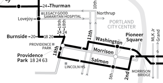
Back in the 1980s, when the current frequent grid network was laid out, there was a controversy about the east-west path that Morrison Bridge buses (now Line 15) should use across downtown. As a result of this, the two directions of service ended up five blocks apart, with westbound buses on Washington St and eastbound buses on Salmon St.
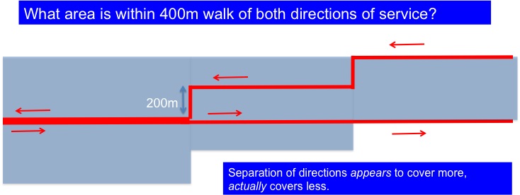
Separating the two directions of service, beyond the minimum required by typical one-way couplets, is a Very Bad Thing, because a service is useful only if you can walk easily to both directions of it.

Blue shows the area with easy access to service. As the directions of service get further apart, the area served gets smaller.
Why was this five-block split ever created? I was hanging around TriMet as a teenager then, so I think I remember. Nobody who designed this liked it. It was a political compromise, partly involving the department store whose large and busy loading dock fronted onto Alder, creating conflicts with buses.
The department store is long gone, but for some reason this was never fixed. I started banging this drum again about a year ago, and the objection I heard was that Alder has too much rush hour traffic, backed up from the bridge. While this is true:
- A problem that happens briefly, like rush hour congestion, shouldn’t define the route that buses use all the time.
- Congestion always happens where people want to go. Designing bus routes to avoid congestion usually implies avoiding logical paths that would be useful to the most people.
- Whatever time may be lost in that backup is far less than the time spent driving ten additional blocks, in the eastbound direction, to go down to Salmon St and back.
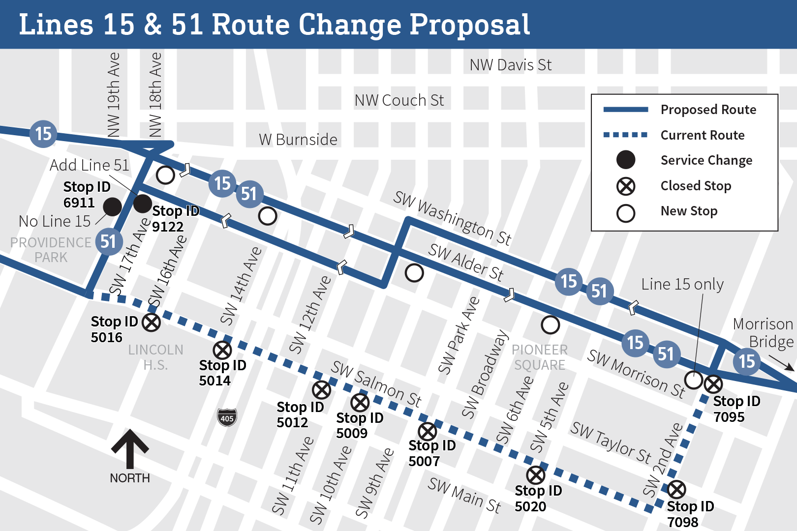
Now, TriMet is finally proposing to fix it:
Now, like any existing routing, some people find the Salmon St routing useful, probably including many municipal and county employees whose main offices are near there. But these people are already walking from distant Washington St to travel in the other direction anyway, so they’re proving that they can.
If you live in Portland, please comment on this! Tri-Met is taking feedback here. As always, you must comment if you like an idea, not just if you hate it. Negative comment predominates on almost all service changes, because people who like a change take it for granted that it’s happening anyway. Don’t be part of that problem! Comment here. There’s other cool stuff to comment on there too!


“Separating the two directions of service, beyond the minimum required by typical one-way couplets, is a Very Bad Thing, because a service is useful only if you can walk easily to both directions of it.”
Not true. The usefulness of a service is determined by the total walking distance in both directions. If you have to walk 600 m one direction and 200 m the other direction, that’s exactly the same as walking 400 meters both directions. This means that if the buses in the different directions are separated by 400 meters, the area served is exactly as large as if the buses goes the same way in both directions. Your diagram is wrong.
::image of Micheal Jackson eating popcorn in a theater::
Taken to the logical extreme, if you have to walk 800m in one direction and 0m in the other (because the bus stops literally right at your front door), that’s exactly the same as walking 400m in both directions too. Why not push one direction of Route 15 over a few more blocks then? But, I guarantee you that if that was done, ridership would fall on it (even if only a bit). Why? Because “total walking distance over the entire day” isn’t the only consideration people have in taking transit. Most also have a maximum “walking distance per segment” threshold. And it’s entirely possible – especially for people with mobility issues – that 600-800m is “too far, even if I only have to do it once a day” while 200-400m is “doable, even if I have to do multiple times a day.”
A personal anecdote: there’s a frequent bus route about 1.25 miles away from my house. It comes every 10 minutes or better. But I never walk over there to catch it, preferring a route that is only 0.25 miles away from my house that comes every 30 minutes. Why? Because I’m not willing to walk 1 more mile to save 20 minutes. I probably could save time by walking over there: I walk pretty fast, and can walk a mile in about 15 minutes. But it exceeds my maximum walking threshold, especially since I have plantar fasciitis that occasionally flares up if I walk “too far” without rest. They could make that frequent route operate every 3 minutes or better, and I still wouldn’t walk that far unless I just missed my local route and was desperate to get somewhere on time, or they completely cancelled my local route to free up the buses for that other route.
If this maximum walking threshold holds true for me in choosing between bus routes with different headways to take, it definitely would hold true for someone in Portland deciding whether the distance between directions on Route 15 is “too much walking” for them.
I notice many bus routing issues like this in many cities, where there is a much more direct way they could be taking. It particularly annoys me with express buses such as the MetroX buses here in Halifax. I think that for express buses, all cities should allow the drivers to take a different route if no stops are missed in case of traffic congestion on the normal route or better traffic conditions on another route.
For people with mobility issues, one-way splits are actually a good thing, since it increases the accessible area, even though you might have to transfer to the bus in the opposite direction.
Anyone with mobility issues is already going that full distance to access one direction, so why can’t they do it in the other direction? They’re sort of proving it’s not an excessive burden by riding the bus even though only one direction is close to them.
You’re also ignoring all the people with origins/destinations on Alder who would no longer have to four blocks to or from the eastbound bus.
At the end of the day, with something like this some people will be better off and some people will be worse off when it comes to people with origins or destinations downtown. It’s a wash. But all the people riding through downtown will be unquestionably better off, so the more direct option should win out.
I agree with Dave. People respond to maximum walk more than average walk.
when routes split, nobody is 0m from service in both directions. There might not be a net decrease in the number of people with a moderately long walk, but there is certainly a reduction in the number of people within a fantastically short walk.
Yes, exactly. Imagine there are people who are willing to walk only one block. Any more than that, and they won’t ride the bus. If the buses run three blocks apart, there are no destinations served by the bus that will work for them. None. The same logic applies as the lines are moved farther apart. If the lines are two miles apart, you aren’t going to get very many people, as most riders aren’t willing to walk a mile from their bus stop (the minimum distance to any destination served both directions).
The 400 meter “limit” is just a general rule of thumb. We know people are willing to walk further, and we know people aren’t willing to walk that far. As it stands now, the buses are five blocks apart, which means that people unwilling to walk more than two blocks are out of luck. The number actually increases to three blocks for most destinations, since there aren’t bus stops every block on Washington and Salmon.
Which is another issue. Since the lines are spaced too far apart, any sort of stop diet (increasing the distance between stops) would have a more dramatic impact on ridership. This makes it harder to improve the stop spacing.
“If you have to walk 600 m one direction and 200 m the other direction, that’s exactly the same as walking 400 meters both directions.”
That’s true. However, placing the two directions further apart does create a floor for a minimum round trip walking distance necessary to ride the bus to get anywhere. For example, if both directions use the same street, it is possible to reach at least some destinations along that street without needing to walk at all. If the two directions are three blocks apart, every round trip that uses that bus route is guaranteed to require a minimum of three blocks of walking – even if the destination in question is right next to a bus stop (*).
This is important because the affect of walking distance on service quality is ultimately a continuum, not some arbitrary threshold, with each additional block making the trip slightly less attractive than would be otherwise. Even if there is no difference between 600m one direction, 200m the other vs. 400m both directions, the fact still remains that placing the two directions 500m apart guarantees that there will be zero trips served whose round-trip walking distance is less than 500m(*).
On top of all this, placing different directions of the same route further apart tends to make the whole transit network less legible and harder to understand. After getting off the bus going one direction, you shouldn’t have to walk around in circles for half an hour – or consult your phone – to figure out where to catch the bus to go back the other direction. Ideally, you should simply see your return bus stop when you get off, and know immediately where to go.
(*) Barring transfers to the same bus going the opposite direction, which is likely slower than walking in most cases.
Wha??? So if someone lived right in front of one bus stop (25 feet) and the bus stop for the other direction was 775 feet away, that would be the same as if they walked 400 feet in each direction? In what universe could that possibly be true? People have a limit to how much they will walk at one time, not some kind of daily allowance of walking that they can use up in any combination.
Personally, I find that one-quarter mile is about how much I will walk at a time to access transit without starting to get seriously annoyed and consider not riding transit at all. This happens to be the transit industry rule of thumb for typical walking distance people prefer when walking to transit.
Johnny, so what about passengers on the edge of the catchment?
Right now, Salmon and Washington st are 400m apart.
So someone might walk 500m to reach Salmon St, but then has to walk 900m on their return trip.
In the present system, I take the 15 in to work but almost never take it back: I go the other way and pick up the 19 or 20 instead. It’s not a big deal, but — it makes the bus system feel arcane and complicated. And arcane and complicated is not what I want at 5:05 on a workday 🙂
So I went and commented over there. Thanks Jarrett!
” the objection I heard was that Alder has too much rush hour traffic, backed up from the bridge”
In some cases it makes sense to run the route in a different way. But in this case, it doesn’t. The bus has to get from Burnside to the Bridge (https://goo.gl/maps/pJHuD5Kbdp2iU9yJ9). Presumably, this is where lots of other people want to go. Any alternative not only takes longer, but would be just as slow. If not, then other cars would use that route, thus making it just as slow. As Google clearly shows, the fastest way (on average) is to go straight, even during rush hour (https://goo.gl/maps/bc28oxWphd6JpCME6). And this is for a car, which is a lot more nimble than a bus.
It would be different if the idea was to cross over the freeway. In that case, running on a street that doesn’t have an on-ramp can save lots of time. But that isn’t the case here. There is no good reason to keep this detour. The route should be changed as you suggest.
Great comment! It just makes sense that you would want to route the bus the same way Google Maps routes cars, even if there is some congestion, because Google is still sending people on the most efficient route.
“Congestion always happens where people want to go. Designing bus routes to avoid congestion usually implies avoiding logical paths that would be useful to the most people.”
Great comment, and highly relevant to the project I’m working on at the moment. I might need to use this quote.
To a certain extent, it depends on whether the place causing the congestion is the same place the bus is going.
I can easily think of a case where it isn’t. For example, there may be congestion caused by the freeway, and the bus is not getting on the freeway. In that case, detouring around is quite reasonable. The 330, in Seattle, makes a dogleg, so that it can cross the freeway at 155th, instead of 145th (https://kingcounty.gov/depts/transportation/metro/schedules-maps/route/330.aspx#route-map). It does this because 145th has ramps, and 155th does not (which means that 155th is a lot less congested).
In this case, though, the congestion is caused by cars headed over the bridge or cars headed to Alder — the exact same bridge the bus has to cross. The bus shouldn’t detour.
I’ve been in situations like this, and people wanting to go eastbound will take a westbound trip to a transfer point. Longer journey, but shorter walk.
Finally, this change is long overdue!
Jarrett, there is more to this reroute as well. TriMet is working with PBOT on a BAT lane on Alder from the transit mall to the Morrison Bridge, which should alleviate some of the issues with congestion on Alder. However, it remains to be seen if it will solve it entirely, as I would occasionally witness traffic backing up beyond 11th Ave during pre-COVID times.
But it’s not like Salmon Street was much faster, as buses were routinely stuck in congestion there as well ON TOP of the route deviation.
“Separating the two directions of service, beyond the minimum required by typical one-way couplets, is a Very Bad Thing, because a service is useful only if you can walk easily to both directions of it.”
The walk is less than a quarter mile. It seems a bit strange to say people can’t “easily walk to both directions” of it, when a quarter mile is the industry standard and you yourself commonly use such a buffer in your own analysis.
If you take a quarter mile as the acceptable walking lint, then a line that runs on two streets a quarter mile apart has a catchment a quarter mile wide. If the routes run down the same street in both directions then the catchment is a quarter mile wide *on both sides*, i.e., the catchment is doubled. Jarrett’s book, Human Transit, has an entire chapter on this subject.
I find your point about designing routes to avoid congestion interesting. Here in York (UK) the number 6 takes a very winding route through Clifton Moor and Clifton, which *outside peak times* added several minutes to the journey. However, when traffic is queuing past the junction the bus emerges from, they save time by pulling out in front of that traffic…
“Whatever time may be lost in that backup is far less than the time spent driving ten additional blocks, in the eastbound direction, to go down to Salmon St and back”
I agree with this statement.