Portland

Portland: Turning the Dial Toward Equity (How Far?)

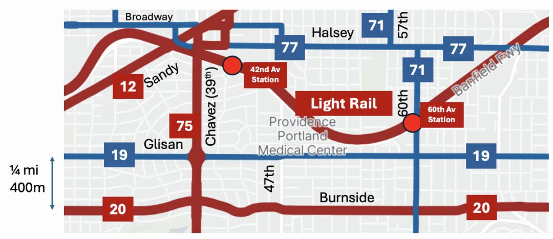
What does it mean to make a bus network design more equitable or “just”?  These terms mean different things to many people, but in this case the core idea is a redistribution of bus service resources, particularly toward people with lower incomes also toward historically excluded racial groups.

In Portland, where I live, we’ve been working with the local transit agency TriMet on a bus network design effort that has two overriding motives: ridership and equity.  And as we look at how much to invest in equity, we have a big question for the community to think about:  How much redistribution of service toward lower-income areas should we do?

TriMet’s project will eventually develop a near-term plan for expanded bus service.  Thanks to a new Oregon state funding source and some other revenues, the agency has the financial capability to run about 10% more bus service than it ran in 2019, and more than 30% more than TriMet runs right now.  The constraint at the moment is the dire shortage of bus operators, but once that’s resolved this level of service will be possible.

These goals, ridership and equity, overlap more than they differ.  If we were planning only for ridership we’d still offer good service where there are lots of people with low incomes even if equity weren’t a separate goal.

However, there are cases where people with low incomes need services that wouldn’t have especially high ridership.  With the suburbanization of poverty, more and more of these people live in areas with low density and/or street networks that present obstacles to efficient bus service.  Another example is service to industrial areas: These tend to have poor ridership because of the low density and terrible pedestrian environment, but they are much valued by the people who rely on them to get to lower-wage jobs.  So in these cases, the equity goal is the only reason we suggest more service there.

Note the word suggest.  The Service Concept we’ve released is just that, a concept.  It is not even a proposal, and it’s certainly not a recommendation.  We are not saying that we have it right.  We are putting it out there to start a conversation.

We drew the Service Concept map around a conference table with TriMet planning staff, and in an earlier phase we also had staffs of most of the cities and counties in TriMet’s service district as well.  In our professional judgment, it’s a good illustration of what you might do if you were trying to expand both ridership and equity.  We’re sure the public feedback will give us lots of great ideas for how to refine it.

But we are also asking the public a specific question:  How far should we shift the priorities toward equity?

One approach you could take is to spend the new resources on the needs of people with lower incomes, while retaining all the services that are there now.  This would get you some improvement in equity, but we wondered if that would be enough to match the public’s priorities.

So we (staff and we the consultants) decided to put out an illustration of what it might look like to turn the dial even further toward equity.

The concept map cuts some existing services to make an even larger investment in equity-improving services. The service cuts happen in places where the service has neither a ridership justification nor an equity justification.  These areas are low ridership because of physical features like low density, poor walkability, or disconnected streets.  They’re also low equity priorities because they have relatively few people with lower incomes.

In shifting service in this way, from higher-income areas to lower-income areas, did we go too far or not far enough?  That question is purely about values.  It has no technical answer.  That means that my opinion doesn’t matter and I won’t express one.  We are asking the community this question, as part of TriMet’s survey about the concept, and that will lead to a decision by the Board on how far we will turn the dial in creating the final plan.


Portland: A 30-Year Old Kludge Finally Fixed

Living in Portland, I still care about the details of transit network planning here, and here’s a thing that Portland folks should comment about, especially those who deal with downtown.

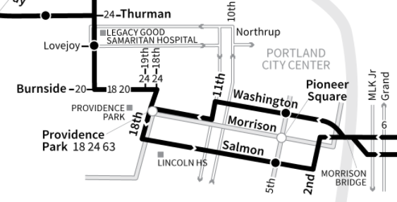
Back in the 1980s, when the current frequent grid network was laid out, there was a controversy about the east-west path that Morrison Bridge buses (now Line 15) should use across downtown. As a result of this, the two directions of service ended up five blocks apart, with westbound buses on Washington St and eastbound buses on Salmon St.

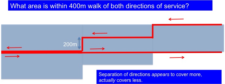
Separating the two directions of service, beyond the minimum required by typical one-way couplets, is a Very Bad Thing, because a service is useful only if you can walk easily to both directions of it.

Blue shows the area with easy access to service. As the directions of service get further apart, the area served gets smaller.


Why was this five-block split ever created?  I was hanging around TriMet as a teenager then, so I think I remember.  Nobody who designed this liked it.  It was a political compromise, partly involving the department store whose large and busy loading dock fronted onto Alder, creating conflicts with buses.

The department store is long gone, but for some reason this was never fixed.  I started banging this drum again about a year ago, and the objection I heard was that Alder has too much rush hour traffic, backed up from the bridge.  While this is true:

  • A problem that happens briefly, like rush hour congestion, shouldn’t define the route that buses use all the time.
  • Congestion always happens where people want to go.  Designing bus routes to avoid congestion usually implies avoiding logical paths that would be useful to the most people.
  • Whatever time may be lost in that backup is far less than the time spent driving ten additional blocks, in the eastbound direction, to go down to Salmon St and back.

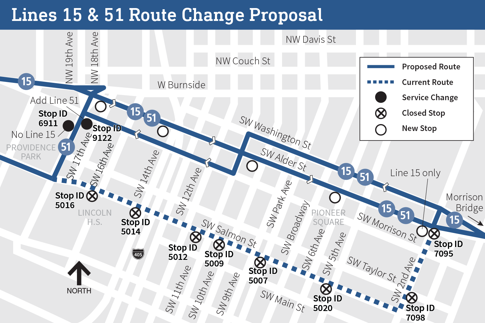
Now, TriMet is finally proposing to fix it:

Now, like any existing routing, some people find the Salmon St routing useful, probably including many municipal and county employees whose main offices are near there.  But these people are already walking from distant Washington St to travel in the other direction anyway, so they’re proving that they can.

If you live in Portland, please comment on this!  Tri-Met is taking feedback here.  As always, you must comment if you like an idea, not just if you hate it.  Negative comment predominates on almost all service changes, because people who like a change take it for granted that it’s happening anyway.  Don’t be part of that problem!  Comment here. There’s other cool stuff to comment on there too!


Livability and Protest in Portland: An Interview with Me

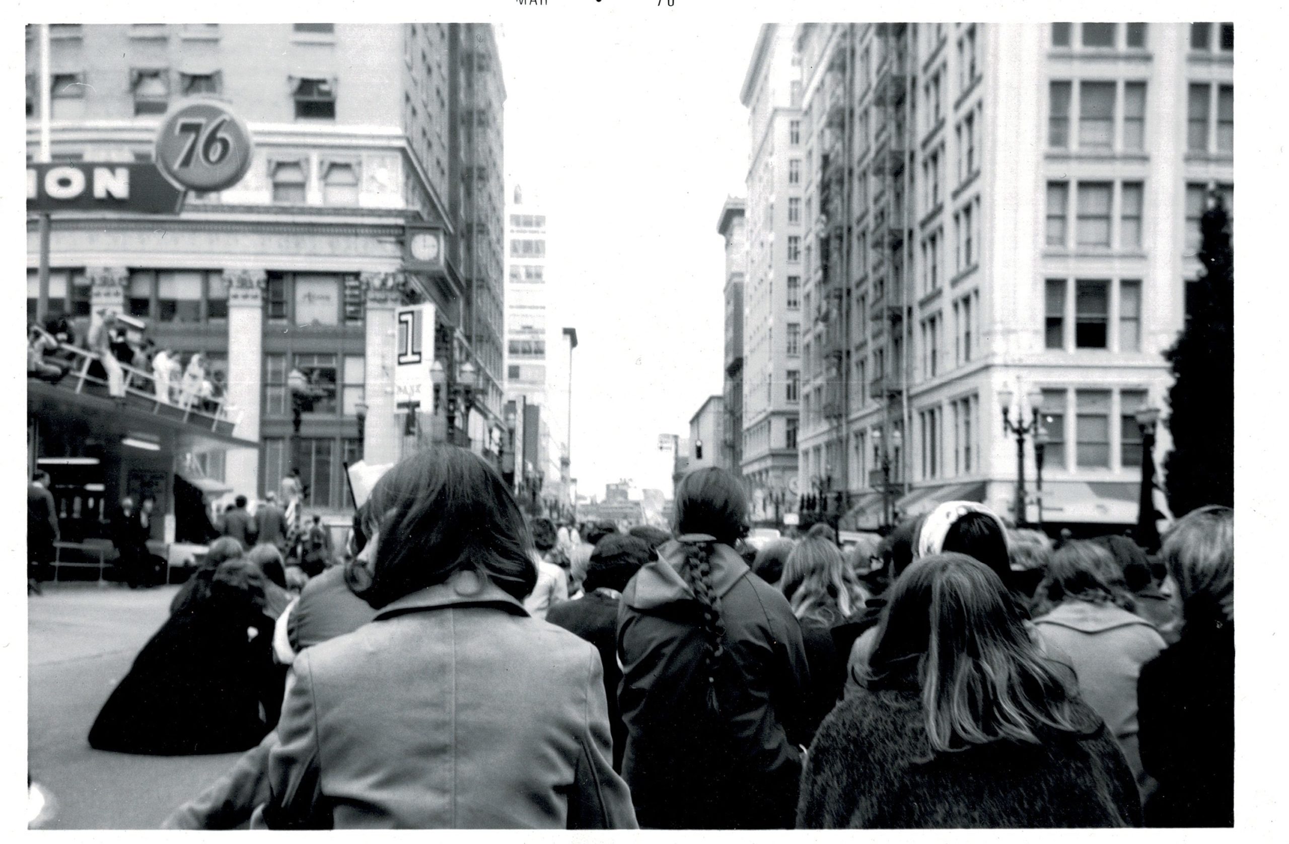
Protest against the Vietnam war in March 1970. Bonus points for knowing not just where this photo was taken, but also what the giant neon sign at the end of this street said.

Oregon Public Broadcasting has posted an interview with me about how Portland’s reputation for livability is related to its reputation for protest.  OPB’s Geoff Norcross is a great interviewer, and it was a fun conversation.  The audio and transcription are here.

“Through our livability, through the way we’ve built the city, we’ve created the stage on which those protests can express themselves effectively, but also attracted the kinds of people who are inclined to protest, who already see themselves to be as rejected by the system and want to stand up to it.”

Portland Plans Faster, More Reliable Buses

The Portland Bureau of Transportation has released the long-awaited Enhanced Transit Corridors plan, a set of policies and strategies to increase the speed and reliability of Portland’s major bus lines.  As in many cities, Portland’s bus lines have been slowing down about 1% a year, which is slowly eating away at people’s access to all kinds of opportunity.

The plan also points the way for the City of Portland to be a more active leader in transit policy, much as the City of Seattle has done so effectively.

The Portland Bureau of Transportation invited me to draft the Executive Summary, which offers some examples of ways to make this topic urgent for more people.  I’m happy with how it came out, and people fighting similar battles in other cities may find it useful.

Here’s the Executive Summary.  Here’s the rest of the report.

Portland residents: Have your say at or before the City Council hearing on June 20 at 2 pm, in the Council Chambers.  You can also submit comments before June 20 by writing to cctestimony at portlandoregon dot gov, cc: etcplan at portlandoregon dot gov.  It would be great if our City Council heard, loud and clear, how important this effort is.


Portland: Two New Plans to Watch

In most US cities, the city doesn’t control the transit agency, but it does make huge decisions that largely govern whether transit can succeed.  Cities control land use planning, which determines the number of people and jobs that are in places where transit can compete for them, and they control street design, which has a powerful impact on whether buses can operate reliably.  Other city functions, like parking and law enforcement, also have a big impact.

So we get great outcomes only when city government takes a strong leadership role on transit, partnering with the transit agency but also leading in the areas that it controls.

Two new plans out of the Portland Bureau of Transportation show the City of Portland rising to that challenge: the Enhanced Transit Corridors Plannow in public comment, and the Central City in Motion plan, which is just beginning.  While the city has nice transit priority policies and has done a few bus lanes before, we’re now seeing an effort to think more systematically about how to get buses moving again.

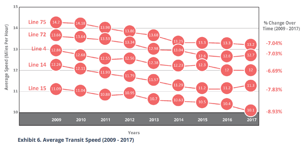
Short term indicators are not good:  Ridership is falling and buses are slowing down.  Indeed, bus operating speed is the ultimate boiling frog problem:

Source: Portland Bureau of Transportation, Enhanced Transit Corridors Plan, Feb. 2018, page 9


As traffic grows, speeds fall just gradually enough that the problem never makes the headlines, but a decade of this adds up to a major loss of access to jobs and opportunity.  We’re seeing this rate of drop — around 1% a year — in many growing cities we work in.  This chart shows the city’s busiest frequent bus lines, which collectively add up to a huge share of the transit ridership.

Losing about 10% over a decade doesn’t just mean that people’s trips are longer, but also that 10% more buses must be deployed to maintain the same frequency, consuming funds that could otherwise be spent on growing the network.

Portland’s Enhanced Transit Corridors plan is the first systematic look at this in a long time.  Focusing on the Frequent Network where the stakes are highest, the plan identifies critical points where work must be done to improve performance.  The plan doesn’t choose which transit priority treatments to do where; that’s the work of more detailed engineering.  But it does lay out the big picture and helps to define priorities.  Read the plan and follow it.  (There’s also a survey about it, closing March 26)

Many of the most critical problems are around the edges of downtown, where many routes converge on chokepoints — most commonly the bridges — that are also places where traffic converges.  The Center City in Motion plan is where those problems will be addressed in detail.  There’s also a chance to rethink the role of parallel streets to reduce conflicts between different modes.

This is a big change for Portland.  Too often in the past, the city has plan different modes in isolation — the bike network here, the freight network there, a streetcar plan here, the transit agency’s plans over there — when the best solutions arise only from thinking about all the modes together and how they can best share a limited transportation network.  I’ve worked on studies that do this, in Seattle and Minneapolis, and it’s great to see Portland finally insisting on this kind of thinking.

If you want to get in the weeds, here’s my own starting wishlist for the Center City in Motion plan:

  • Proper transit priority on approach to all of the congested bridges, and between the bridges and the transit mall.
  • Integrated planning of bike and transit to reduce bike-transit conflicts.
  • Reviewing all the east-west transit routings in downtown, possibly consolidating them onto fewer streets.
  • Making better use of the Transit Mall for buses.  At this point I wonder if too many routes have been removed from it and we are not getting enough value from our premiere transit priority facility.
  • Fixing the unacceptable 5-block separation of the two directions of Line 15-Belmont/23rd downtown.

If you live in Portland, get on the mailing list and share your own views!


Portland: A Chat with the Transit Board of Directors

On November 8 I was the guest of the Board of Directors of the Portland area transit agency, TriMet, for a two hour workshop on issues facing the agency.  It was not so much a presentation as a freewheeling discussion, where Board members got to engage with me, question some of my ideas, and sharpen their own views.  I rarely have a chance to engage with transit planning in my own home town, so I was really honored by this opportunity.

Most of you have much better things to do than listen to two hours of this, but for those special folks who love these things, it’s here.  There’s some cool new philosophical stuff at the beginning.

My part runs 0:24:26 to 2:28:30. There’s some further relevant Board/staff discussion, about where to go with the agency at 3:50.


Notes on the Portland Terror Attack

Portland — where I grew up, and where I live again now — isn’t used to being attacked, but I’m proud of how many there are responding.  The terror attack on our light rail system, in which two men were killed and another injured for trying to stop the abuse of Muslim passengers, has been understood as an attack on the city itself.

If citizens cannot accommodate the ways they are different from one another, a democratic city is impossible.  Diversity — and the principle of kindness toward people who are different from you — is as essential to our city’s functioning as a water supply is.  So attacks on diversity are as much of a threat as attacks on our water supply.

Public transit, in particular, is always under attack, in part because of the levels of mutual respect that it requires.  No moment in urban life requires such intimate contact with diversity as the time spent on transit.  You are closer than you might like to people who are different from you, and unlike on the street, you can’t just walk away.  Sharing space on a bus or train requires 100 little adjustments, tiny acts of respect or accommodation.  Not everyone can do this.  So for those trained to read diversity as danger, hatred of public transit is understandable.

The healthiest response to this kind of attack, I think, is to take it personally, as most Portlanders I know are doing.  We should understand that the hatred is directed at each of us.  This is moral outrage that resonates through at least three tiers of concern:  It’s an attack on our own values as individuals, and also on our city, and also on the whole idea of civilization.  Feel how similar those three ways of being offended really are.

Then respond with an outrage that remains fused with kindness for one another.  For that is the whole point.

Portland’s Division Transit Project: A New Kind of “Rapid” Urban Bus

For the past few years, planners at the transit agency TriMet and MPO Metro in Portland have been carefully shepherding the development of a new sort of transit project for the city.  It’s turning into a new sort of transit project, period — one that doesn’t fit in the usual categories and that we will need a new word for.

The Powell-Division Transit and Development Project extends from downtown across Portland’s dense inner east side and then onward into “inner ring suburb” fabric of East Portland — now generally the lowest-income part of the region– ending at the edge city of Gresham.  It was initially conceived as a Bus Rapid Transit (BRT) line, though one without much exclusive lane.  It would be a new east-west rapid element in Portland’s high-frequency grid, and also serves a community college and several commercial districts.

(Full disclosure: JWA assisted with a single workshop on this project back in 2015, but we haven’t been involved in over a year.).

Below is a map of how the project had evolved by 2015, with several routing choices still undetermined.  From downtown it was to cross the new Tilikum bridge and follow Powell Blvd. for a while  Ironically, as inner eastside Portland began to be rethought for pedestrians and bicycles, decades ago, Powell was always the street that would “still be for cars.”   To find most of the area’s gas stations and drive-through fast food, head for Powell.  As a result, it’s the fastest and widest of the streets remaining, but correspondingly the least pleasant for pedestrians.

Half a mile north is Division Street.  For the first few miles out of downtown, Division is a two lane mainstreet, and it’s exploded with development.  It’s on the way to being built almost continuously at three stories.  Further out, Division is one of the busier commercial streets of disadvantaged East Portland, though still very suburban in style as everything out there is.  (For an amusing mayoral comment on that segment, see here.)

Because dense, road-dieted Division is very slow close to the city but wide and busy further out, the project began out with the idea of using Powell close-in and then transitioning to Division further out, as Division got wider, though of course this missed the densest part of Division, which is closest-in.

Screen Shot 2016-08-17 at 12.54.09 PM

However, very little of the corridor would be separated from traffic. While this project was never conceived as rail-replicating, it was based on the premise that a limited-stop service using higher-capacity vehicles, aided by careful signal and queue jump interventions, could effect a meaningful travel time savings along the corridor, compared to trips made today on TriMet’s frequent 4-Division.  That line runs the entire length of Division and is one of the agency’s most productive lines, but it struggles with speed and reliability.

As it turned out, though, the travel time analyses showed that from outer Division to downtown, the circuitous routing via Powell cancelled out any travel time savings from faster operations or more widely spaced stops.

As a result, planners looked at a new approach, one that would seek to improve travel times by using inner Division, which had previously been ruled out. Inner Division is a tightly constrained, 2-lane roadway through one of the most spectacularly densifying corridors in Portland, and one that is rapidly becoming a prime regional dining and entertainment destination. This development has led to predictable local handwringing about parking and travel options. Here’s what that alternative looks like:

Screen Shot 2016-08-17 at 11.31.52 AM


Screen Shot 2016-08-17 at 12.28.31 PM

Proposed Division station locations


Screen Shot 2016-08-17 at 12.29.34 PM

Current 4-Division eastbound stops

The new plan is basically just stop consolidation with some aesthetic and fare collection/boarding improvements. But the stop consolidation would be dramatic.  Note that one numbered avenue in Portland represents about 300 feet of distance, so the new spacing opens up gaps of up to 2400 feet.  If you’re at 30th, for example, you’d be almost 1/4 mile from the nearest stop.

Such a plan would be controversial but quite also historic.  It’s a very wide spacing for the sole service on a street.  On the other hand, the wide spacing occurs on a street that is very, very walkable — one of the city’s most successful “mainstreets” in fact.  And it’s basically the only way to optimize both speed and frequency on a two-lane mainstreet like inner Division.

At this point, it would be strange to call this project “BRT” (Bus Rapid Transit); even the project webpage refers to this alternative as “Division rapid bus”.

Disappointing as this will be to those who think BRT should emulate rail, it has one huge advantage over light rail.  In Portland, surface light rail tends to get built where there’s room instead of where existing neighborhoods are, so it routinely ends up in ravines next to freeways, a long walk from anything.  This Division project now looks like the answer to a more interesting question:  What is the fastest, most reliable, most attractive service that can penetrate our densest neighborhoods, bringing great transit to the heart of where it’s most needed?

This is such a good question that we shouldn’t let arguments about the definition of “BRT” distract from it.  Because it’s not a question about technology.  It’s a question about people.

Screen Shot 2016-08-17 at 2.34.25 PM

Line 72 stopping pattern (Powell to Division, approx. 0.5 mi)

Upgrading the 4-Division to a rapid bus line (without underlying local service, which is impossible due to the constrained roadway) should present a real improvement in quality of service (in terms of capacity using the larger vehicles, and in a 20-25% travel time savings), while at the same time being easier to implement and less disruptive to existing travel patterns.

It also provides a template for TriMet to consider stop consolidation and frequent rapid service on other corridors like the aforementioned Line 72. Rather than seeing this as a failure to design a rapid transit project, perhaps we can celebrate a process that has steered away from a path that would have resulted in a disappointing outcome, towards a more limited, more economical, but still meaningful improvement for riders.

Riding Against the Grain: A Photographer on Portland’s Line 75

img_2324

Portland-based photographer Geoffrey Hiller is best known for a marvelous book Daybreak in Myanmar, which interleaves pre- and post-revolution images of that country.  Now he’s turned his attention to one of Portland’s most interesting bus lines — at least in terms of the diversity of unsung corners of the city that it serves, and the beautiful and often eccentric people who live and do business there.   His blog lays out the work in little photo vignettes with commentary.  It’s wonderful.

img_4529

I did an essay for his blog and any future book, in which I say things like …

As it makes its long orbit around Portland, then, the 75 tours the shifting front lines of many epic struggles. Gentrification loves the bohemian but chases it away. Defenders of history scream “stop demolishing Portland!” even as a desperate need for housing calls for bigger buildings. And in parallel, everywhere on the 75, you can watch the parallel dramas of power and weakness: power struggling to protect itself, while others struggle for survival and dignity.

To this shifting landscape, Geoffrey Hiller is the perfect guide. He knows you’ve seen the real estate photos, the chamber of commerce photos, the tourist photos, and the photos of cashed-up millennials in designer grunge luxuriating in sculpted authenticity. He wants you to see something else. Here is the Portland in between things, the struggling and hopeful Portland, the Portland that’s happening anyway despite everyone’s grandest plans.

You might find it a useful accompaniment to Geoff’s photos.  It’s all about a Portland you may have missed in your perusing of real estate magazines, or for that matter your urbanist-guided tour.


All photos: Geoffrey Hiller