Bus Rapid Transit

Bogotá: TransMilenio a los 25 años: la infraestructura y el debate

(Read in English here.)

El famoso sistema de Transporte Rápido por Bus de Bogotá, TransMilenio, cumple ya un cuarto de siglo. El mes pasado tuve por fin la oportunidad de recorrerlo, junto a mi colega colombiano Álvaro Caviedes y con el profesor Dario Hidalgo, experto en transporte de la Universidad Javeriana. Tengo algunas reflexiones que compartir.

La tasa de motorización en Bogotá es inferior al 20%. Así que cuando hablamos del transporte público bogotano, hablamos de las arterias principales por las que funciona la ciudad. No sorprende, entonces, que casi todo el mundo en Bogotá tenga opiniones muy firmes sobre la planificación del transporte.

Bogotá, con diez millones de habitantes, no tiene transporte rápido sobre rieles. En cambio, tiene TransMilenio, la red de Transporte Rápido por Bus más grande de América Latina. Fue un sistema pionero, pero en muchos aspectos ya no está funcionando bien. Está sobresaturado, tiene problemas de seguridad y se ve fácilmente interrumpido por manifestaciones o disturbios. Los debates sobre si estos problemas tienen solución dentro de la infraestructura actual son acalorados, y muchas voces simplemente odian “TransMilenio” y todo lo que ese nombre connota. La aprobación ciudadana ha ido cayendo, aunque muy recientemente se ha recuperado un poco.  Solamente el 42% de las personas siente orgullo por TransMilenio como sistema de transporte.

Décadas de debate sobre si construir un metro —y cómo— han postergado en varias ocasiones la expansión de TransMilenio, de modo que la red actual tiene menos de la mitad de lo que estaba planeado para esta fecha. Hoy, la primera línea del metro, que será totalmente automatizada, está finalmente en construcción, pero es apenas una línea en una ciudad enorme con necesidades de transporte urgentes en todas partes.

Esta es la primera de dos entradas sobre lo que podemos aprender de Bogotá. Esta primera entrega ofrece una mirada general y un recorrido por la infraestructura, que es lo que la mayoría de los visitantes nota y sobre lo que la mayoría de los expertos escribe. Lo ofrezco para orientar a los lectores que quizás no conocen la ciudad ni su red. Pero mi verdadero interés —y mis reflexiones más útiles— están en los patrones de servicio, que son el tema de la segunda entrega.

Recordemos: la infraestructura ayuda a hacer posibles los patrones de servicio, pero son los patrones de servicio (rutas, frecuencias, etc.) los que determinan cuándo llegarás a donde vas. Esta es la diferencia más importante entre el transporte público y la construcción de carreteras o la arquitectura. Construyes una carretera o un edificio y puedes usarlos de inmediato. Construyes una línea de tren o un corredor de buses y simplemente está ahí hasta que determines cómo operar los vehículos y qué patrones de servicio seguir. Como la construcción de carreteras y la arquitectura son profesiones más prestigiosas que la planificación del transporte, abundan personas que hablan con autoridad en ese campo sin estar suficientemente enfocadas en cómo funciona el servicio, y que incluso toman decisiones que sacrifican el servicio en aras de la infraestructura. (Esta es una observación global, válida para cada una de las más de 100 ciudades en las que he trabajado, no solo un comentario sobre Bogotá.)

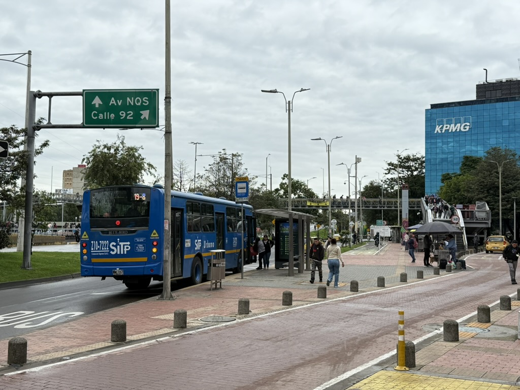
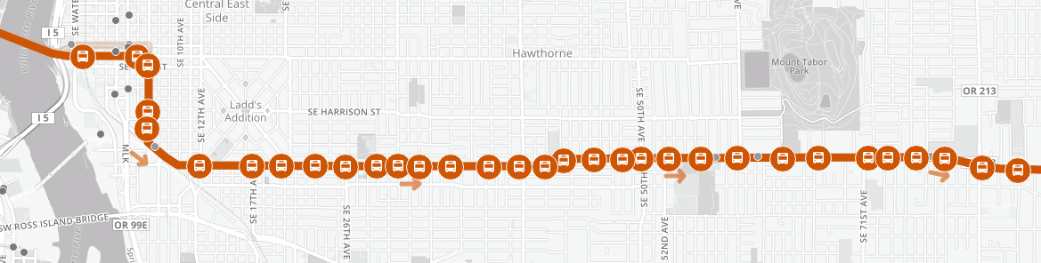
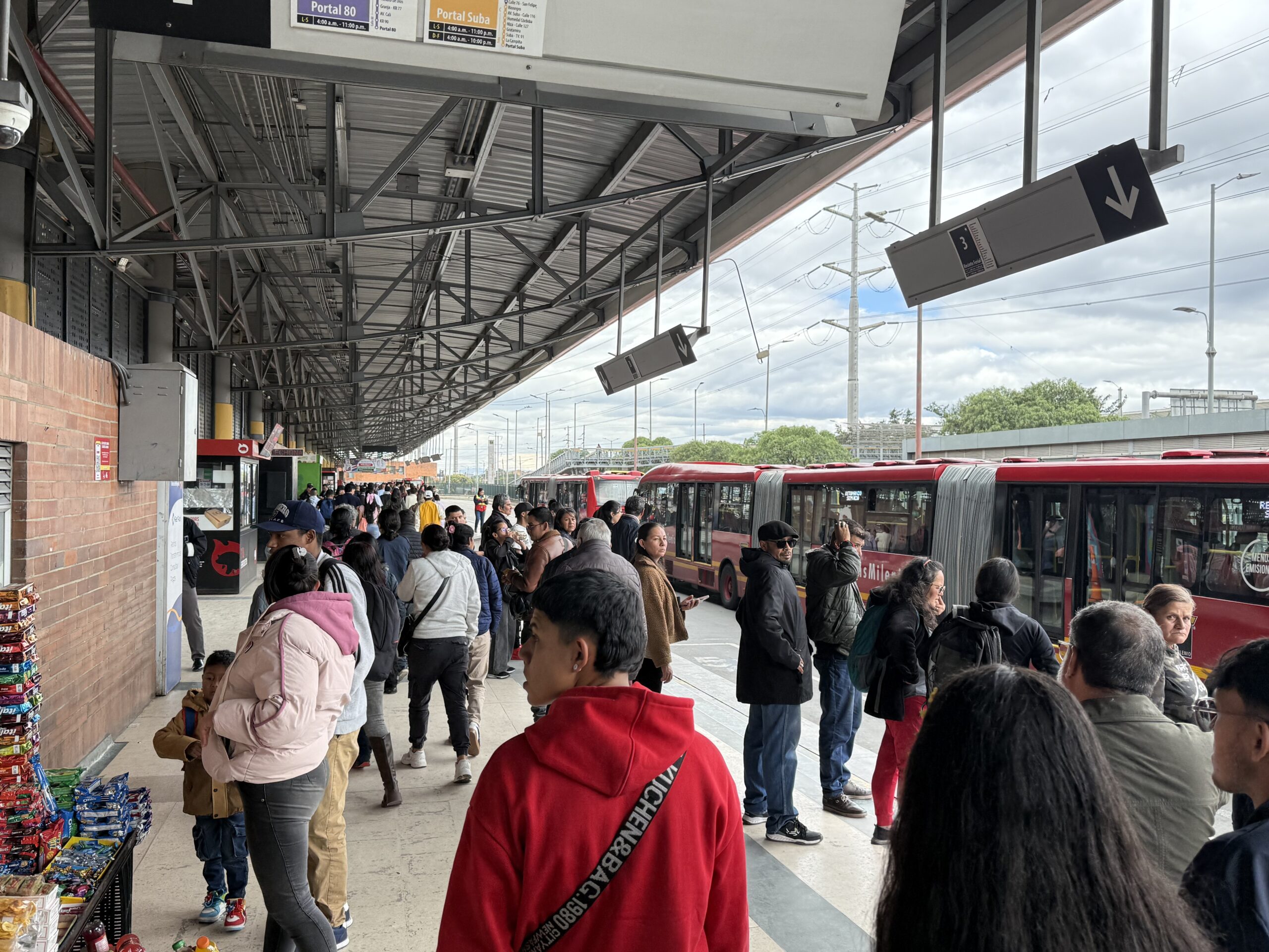
La mayor parte de TransMilenio consiste en un carril central exclusivo construido sobre una amplia avenida, como se ve en la foto de arriba. Las estaciones en el separador central son atendidas por buses muy grandes (27 m) con puertas del lado izquierdo. Las estaciones tienen dos carriles de bus en cada dirección, de modo que los buses pueden adelantarse entre sí. Esto es fundamental para que TransMilenio pueda movilizar volúmenes tan altos de buses a través del sistema, que es la clave de su capacidad extraordinaria: su máximo teórico es de 56.000 personas por hora por sentido (phps) y el máximo observado en su segmento más concurrido es de 43.000. Esto ubica a TransMilenio por encima de todos los sistemas de transporte rápido sobre rieles de Estados Unidos y Canadá, salvo dos segmentos en la ciudad de Nueva York. También compite favorablemente con muchos metros del mundo.

Por supuesto, esto mide cuántas personas se mueven por la infraestructura, no la capacidad de los vehículos ni el uso eficiente del personal. Los buses de TransMilenio son enormes pero mucho más pequeños que los trenes, así que el número de empleados por pasajero es mucho mayor que en los sistemas férreos. Este modelo no funcionaría a esta escala en países ricos donde la mano de obra es costosa, pero en el contexto de Colombia —un país de ingresos medios— resulta viable.

Con todo, la infraestructura presenta también muchos desafíos. Fue construida sobre grandes avenidas porque allí había espacio, pero eso no ubica las estaciones en el corazón de comunidades densas y activas, como sí podría hacerlo un sistema subterráneo. (Montevideo está desarrollando actualmente un sistema BRT con estaciones subterráneas en el centro de la ciudad.) ¿Cómo llega la gente a las estaciones en medio de grandes avenidas? Los puentes peatonales son la solución habitual, pero el resultado es una caminata larga. Puede haber más de 500 metros entre una estación y el lugar más cercano al que alguien quiera ir.

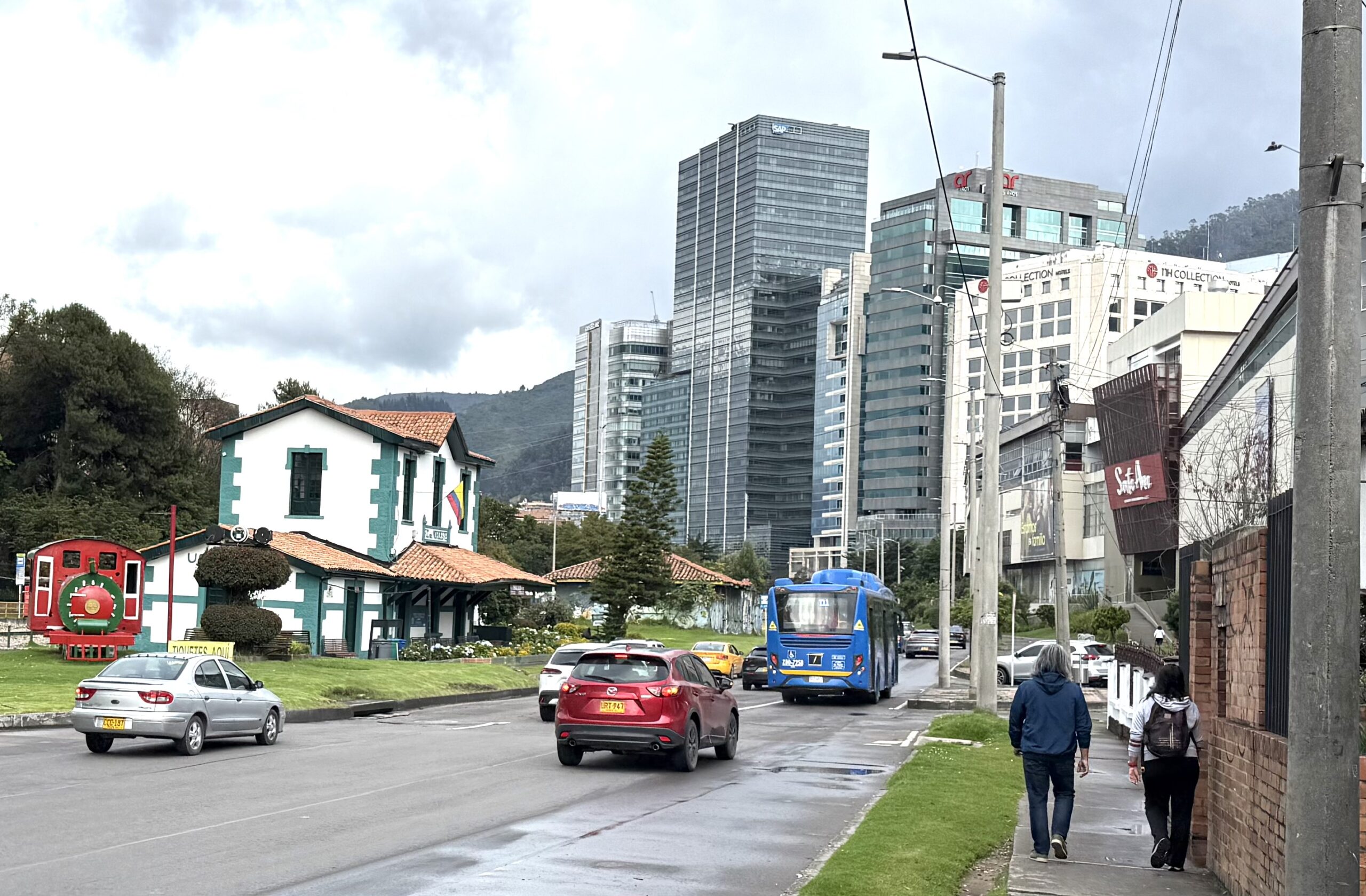
Las propias oficinas de TransMilenio padecen este problema en su peor versión. Se encuentran en el edificio que aparece a la derecha en la foto de abajo. Tienen una vista privilegiada de la estación, que está al final del andén en el separador, pero el trayecto a pie hasta esa estación es de casi 1 km, pasando por el puente peatonal donde está parado el fotógrafo:

Las estaciones de TransMilenio son de acceso controlado. Se entra por un torniquete y, bueno, uno queda encerrado en una jaula de metal abarrotada en medio de una autopista.

Se ha hecho un gran esfuerzo para evitar que la gente cruce corriendo la calzada hacia el andén para evadir el pago, lo que dio lugar al efecto “jaula”.

En los nodos principales, las estaciones son mucho más amplias.

¿Hay belleza en el sistema? Sí: en algunas estaciones de conexión con pasos peatonales subterráneos se han incorporado obras de arte con buen resultado.

También hay un hermoso tramo en el centro de la ciudad, un caso excepcional en el que TransMilenio tiene para sí toda una calle en superficie. (Aun así, solo se puede abordar en las estaciones con control de acceso.)

Las jaulas de las estaciones tienden a congestionarse porque el servicio es complejo: muchos patrones de ruta distintos se detienen en cada estación. Por eso la gente no tiene incentivo para subirse al próximo bus que llega. El resultado es más espera y más hacinamiento en las estaciones. Profundizaré en este problema en la siguiente entrega.

Los buses

Los corredores de TransMilenio son atendidos principalmente por buses biarticulados rojos, diseñados para movilizar grandes multitudes. Como el pasaje se paga en la estación, se puede subir o bajar por cualquier puerta. Estos buses casi siempre van llenos. En un momento dado, el profesor Hidalgo y yo estábamos discutiendo cuál debería ser el estándar adecuado de ocupación para pasajeros de pie. Debatíamos si debía ser 6 personas por metro cuadrado o quizás 8, mientras estábamos apretujados en una multitud que claramente superaba las 10 personas por metro cuadrado.

También existe una variedad de otros tipos de bus. Los que son en parte rojos y en parte verdes o amarillos circulan por algunos tramos de los corredores pero luego los abandonan para continuar por calles comunes. También hay buses alimentadores, que suelen ser verdes, y una variedad de buses locales, frecuentemente azules. Los alimentadores cuentan a menudo con infraestructura extensa integrada a las grandes estaciones de intercambio. En esta foto, el aviso indica que este conjunto de torniquetes es para salir del área de los buses alimentadores verdes, no para entrar. A diferencia de la mayoría de los buses que circulan por calles comunes, los alimentadores verdes no tienen torniquetes a bordo, pues dan por sentado que todos los pasajeros viajan hacia o desde una estación y deberán pasar por estos torniquetes de todas formas.

Los buses azules operan completamente por fuera de la infraestructura de TransMilenio, circulando por calles locales, por lo que cuentan con torniquetes a bordo para el cobro del pasaje.

Por último, muchas rutas de TransMilenio abandonan la infraestructura para continuar por calles comunes. Esta es una de las grandes ventajas del Transporte Rápido por Bus frente al tren. Cuando se llega al final de los rieles, todos los pasajeros deben bajar; los buses, en cambio, pueden seguir llegando a más destinos sin necesidad de hacer transbordo. Sin embargo, al hacerlo pierden puntualidad y claridad para el usuario, por lo que debe hacerse con cuidado. Volveré sobre ese problema en la siguiente entrega.

Recriminaciones, gratitud y el debate del metro

No hace falta explorar mucho las redes sociales bogotanas para encontrar multitudes despotricando contra TransMilenio. Desde sus inicios, TransMilenio ha estado acosado por la infraestructura que no es: un sistema de trenes de tránsito rápido, o “metro”, como se le llama aquí.

Bogotá (10 millones de habitantes) es, con mucho, la ciudad latinoamericana más grande sin ningún tipo de metro o sistema subterráneo. La siguiente en tamaño, Curitiba en Brasil, tiene apenas un tercio de su población y fue una de las primeras pioneras en usar el Transporte Rápido por Bus como alternativa al tren pesado. Esto ha generado durante mucho tiempo la sensación de que Bogotá tomó una decisión equivocada. Es fácil argumentar que los creadores de TransMilenio importaron un concepto de Curitiba a una ciudad simplemente demasiado grande para él, y que desde el principio debieron haber construido un metro.

Pero los metros son tan costosos que, de haber tomado ese camino, hoy tendrían una red menos extensa que llegaría a menos partes de la ciudad. Finalmente están construyendo su primera línea de metro y planificando la segunda, pero tardará mucho tiempo en acercarse a la escala de la infraestructura de TransMilenio, que cuenta con 113 km de corredor exclusivo cubriendo gran parte de la ciudad.

Esto importa porque Bogotá tiene enormes necesidades de transporte. Como muchas ciudades, ha desarrollado un patrón urbano en el que muchas personas —especialmente las de menores ingresos— viven muy lejos de las oportunidades que necesitan. Así que, aunque TransMilenio está congestionado, es difícil de acceder y a veces resulta agotador, es vastamente superior a lo que había antes: un enredo de servicios de bus privados y confusos que a veces se perseguían entre sí compitiendo por pasajeros. Este mural da una idea de cómo se sentía eso:

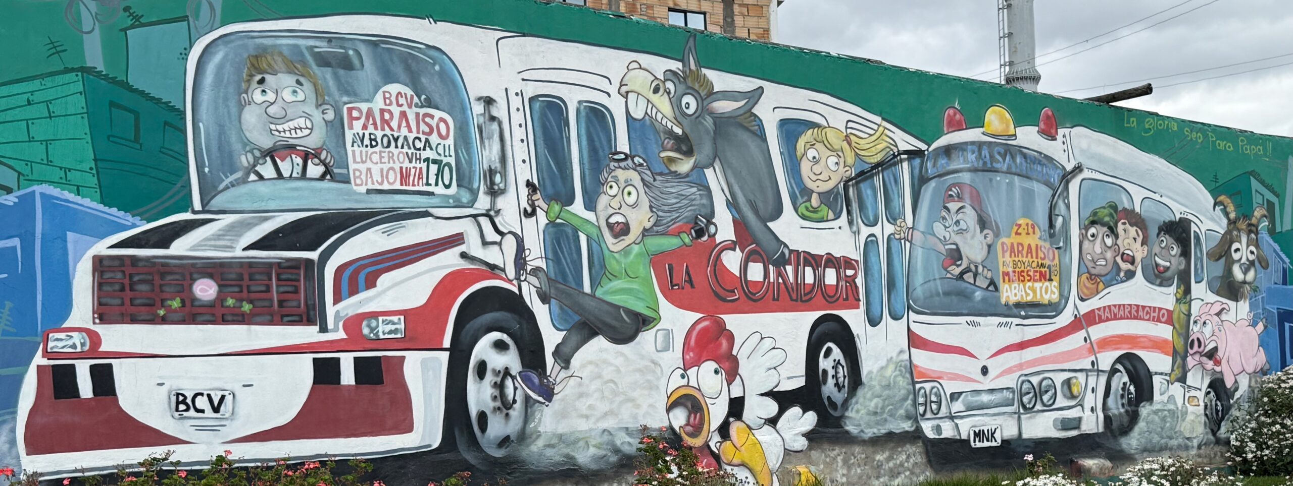
Mural en El Mirador, Ciudad Bolívar

El debate sobre qué debió haberse hecho en los años noventa, cuando se tomó la decisión de crear TransMilenio, no tendrá fin. Los líderes de entonces eligieron una red para toda la ciudad que podían poner en marcha en una década, en lugar de una red férea mucho más pequeña que habría polarizado aún más a la ciudad entre quienes podrían usarla y quienes no. Hoy, los corredores más congestionados de Bogotá han superado la capacidad de TransMilenio y el metro comienza a aparecer. El reto que enfrentan los líderes ahora es mantener la expansión de TransMilenio al tiempo que incorporan líneas de metro a la red.

Pero ese no es su único desafío. Bogotá enfrenta un reto igualmente decisivo en la abrumadora complejidad de su red de transporte público. Esa complejidad es también una razón de peso por la que moverse por la ciudad puede ser tan difícil. Exploremos ese desafío ahora.

Bogotá Transmilenio at 25: The Infrastructure and The Debate

(Leer en español.)

Bogotá’s famous Bus Rapid Transit system, TransMilenio, is a quarter century old. Last month I finally had a chance to tour it, with my Colombian colleague Álvaro Caviedes and also with Professor Dario Hidalgo, a transport expert at Universidad Javeriana. I have some thoughts.

Introduction

Bogotá, population 10 million, has no rail rapid transit. Instead, it has TransMilenio, Latin America’s largest Bus Rapid Transit network. It was groundbreaking, but in many ways it’s no longer working well. It’s overcrowded, it has security issues, and it’s also easily disrupted by demonstrations or civil unrest. Arguments rage about whether these problems are fixable within the current infrastructure, with many voices just hating “TransMilenio” and everything the name connotes. Customer approval has been dropping, though it has recently begun to recover a bit.

Car ownership in Bogotá is below 20%. So when we talk about Bogotá’s public transit we are talking about the primary arteries by which the city functions. So it’s not surprising that almost everyone in Bogotá has fierce opinions about transit planning.

Decades of debate about whether and how to build a metro have at times caused TransMilenio expansion to be deferred, so the current extent of the network is less than half of what was originally planned to be done by now. Today, the first metro line, which will be fully automated, is finally under construction, but it’s just one line in a vast city with desperate public transit needs everywhere.

This is the first of two posts on what we can learn from Bogotá. This first post looks at the big picture and provides a tour the infrastructure, which is what most visitors notice and most experts write about. I offer this to orient readers who may be unfamiliar with the city and its network. But my real interest and most useful insights are about the patterns of service, which is the topic of the second post.

Remember: Infrastructure helps make patterns of service possible, but it’s the patterns of service (routes, frequencies, etc) that determine when you’ll get where you’re going. This is the most important way that public transit is not like roadbuilding or architecture. Build a road or a building and then you can use it. Build a train line or a busway and it just sits there until you figure out how to run trains and buses in it, and decide what patterns the service should follow. Because roadbuilding and architecture are more prestigious professions than transit planning, we have lots of people speaking with authority in the transit planning space who aren’t really focused enough on how the service works, and who will even make decisions that sacrifice the service for the sake of the infrastructure. (This is a global observation, true of every one of the 100+ cities I’ve worked in, not just a comment about Bogotá.)

The Infrastructure

Most of TransMilenio consists of a median busway built into a wide arterial street, as in the picture above. The median stations are served by very large buses (27 m or 88 feet) with doors on the left. Stations have two bus lanes in each direction, so that buses can pass other buses. This is an important part of how TransMilenio can push such high volumes of buses through the system, which is the key to its incredible capacity: Its theoretical maximum is 56,000 people per hour per direction (phppd) and the highest observed on its busiest segment is 43,000. This puts TransMilenio ahead of every rail rapid transit system in the US and Canada except for two segments in New York City. It also stacks up impressively against many metros worldwide.

Of course, this is measuring how many people move through the infrastructure, not vehicle capacity or the efficient use of staff. TransMilenio buses are huge but much smaller than trains, so the number of employees per customer is much higher than in rail systems. This model would not work on this scale in wealthy countries where labor is expensive, but in Colombia’s middle-wealth context it pencils out.

Still, the infrastructure also presents many challenges. It was built into big boulevards because that’s where there was space, but this does not put the stations in the centers of active, dense communities as an underground system could. (Montevideo is now developing a BRT system with underground stations in the city center.) How do people get to stations in the middle of vast boulevards? Large pedestrian bridges are the usual way, but the result is a long walk. It can be over 500m walk from a station to the nearest place that anyone might be going.

TransMilenio’s own offices experience the worst of this problem. They are in a building on the right in the photo below. They have a nice view of the station, which is at the end of the walkway in the median, but their walk to to that station is nearly 1 km, via the pedestrian bridge where the photographer is standing:

TransMilenio stations are fully controlled. You go through a turnstile to enter them, and then, well, you’re in a crowded metal cage in the middle of a highway.

A lot of effort has gone into keeping people from running across the road to the platform to evade the fare, which led to the “cage” effect.

At major junctions, the stations are much more spacious.

Is there beauty in the system? Yes, in a few connection stations that involve underground pedestrian links, nice things have been done with artwork.

There’s also a beautiful segment in the city center, a rare case where TransMilenio has an entire surface street to itself. (Still, you can only board at the fare-controlled stations.)

The station cages tend to get crowded because the service is complex, with many patterns of service stopping at each station. For this reason, people aren’t motivated to get on the next bus that comes. The result is more waiting, and more crowding, in the stations. I’ll explore this issue in the next post.

The Buses

TransMilenio’s busways are served mostly by double-articulated red buses, designed to manage huge crowds. Because you pay your fare in the station, you can board or alight at any door. These buses are almost always crowded. At one point, Professor Hidalgo and I were discussing what an appropriate standard for crowding of standing passengers should be. We debated whether it should be 6 people per square meter or maybe 8, even as we were smashed together in a crowd that was clearly over 10 people per square meter.

There is also a range of other bus types. Buses that are partly red and partly green or yellow run on some part of the busways but then leave them to run along normal streets. There are also feeder buses, which tend to be green, and a range of other local buses, often blue. Feeders often have extensive infrastructure built into major hub stations. In this photo, the sign indicates that this bank of turnstiles is for exiting the area of the green feeder buses, not entering it. Unlike most buses running on normal streets, green feeders don’t have fareboxes, because they assume that everyone is traveling to or from a station and will therefore have to go through these turnstiles.

The blue buses mostly remain outside the TransMilenio infrastructure, running on local streets, so these have fareboxes with turnstiles onboard.

Finally, many TransMilenio bus routes leave the infrastructure to continue on local streets. This is one of the great strengths of Bus Rapid Transit compared to rail. When you get to the end of the rails, everyone has to get off, but buses can continue to reach more destinations without requiring a connection. However, they sacrifice reliability and legibility when they do this, so it needs to be done carefully. I’ll return to that problem in the next post.

Recriminations, Gratitude, and the Metro Debate

It doesn’t take much exploring on Bogotá social media to find great masses of people fulminating about TransMilenio. From the beginning, TransMilenio has been haunted by the infrastructure that it isn’t: A system of rapid transit trains, or “metro” in the local parlance.

Bogotá (population 10 million) is by far the largest Latin American city without any kind of subway or metro system. The next largest, Curitiba in Brazil, is barely a third the size, and was one of the earliest pioneers in using Bus Rapid Transit as an alternative to heavy rail. So this has long felt like something that Bogotá got wrong. It’s easy to argue that the inventors of TransMilenio imported a concept from Curitiba into a city that was just too big for it, and that they should have been building a metro from the beginning.

But metros are so expensive that if they had gone that route, they’d have a less extensive network today, reaching fewer parts of the city. They finally are building their first metro line, and planning the second, but it will take a long time to approach the scale of TransMilenio’s infrastructure, which has 113 km of busway spanning much of the city.

This is important because Bogotá has huge transportation needs. Like many cities, it has evolved a development pattern where many people, especially lower-income people, are very far from the opportunities they need. So while TransMilenio is crowded, awkward to access, and a bit depressing at times, it is vastly better than what was there before: a tangle of confusing privately-provided bus services that sometimes raced each other in the competition for passengers. This mural gives a sense of what that felt like:

Mural at El Mirador, Ciudad Bolívar

There will be no end to the debate about what should have been done in the 1990s, when the TransMilenio decision was made. Leaders at the time chose a citywide network that they could stand up in a decade, rather than a much smaller rail transit network that would only have further polarized the city between winners who could use it and losers who couldn’t. Now, Bogotás busiest corridors have outgrown TransMilenio and the metro is starting to appear. The challenge leaders face now is to keep TransMilenio’s expansion going even as they add metros to the network.

But that’s not their only challenge. Bogotá faces an equally consequential challenge in the staggering complexity of its public transit network. This too is a major reason that traveling around the city can be so difficult. The next post looks at that challenge.

¡Holá, Colombia!

(Español abajo.)

It’s ridiculous that I’ve had a 34 year career encouraging good bus service in many parts of the world and yet had never been to Colombia. Finally, I have my chance.  I’ll be in Bogotá all this week and Medellín for a few days next week, to witness Colombia’s famous public transit for myself.  While Bogotá wasn’t the first Bus Rapid Transit system in Latin America, it quickly grew one of the largest, one that has all the functions of the metro that the city lacks.  (A first metro line is finally under construction now.)  Bogotá is also known for founding Ciclovia, a program that opens many streets to cyclists on Sundays and holidays, and for the world’s largest Day Without Cars, which is coming up this Thursday, February 5.

First impressions of Bogotá:  The dramatic misty mountains right against the densest parts of the city.  The uneven pavements that require pedestrians to watch their feet.  But above all: the joy of a clear grid!  Colombian cities mostly have numbered streets in both directions, so that every address is a set of co-ordinates that tell you where you are in the city and how far any other address is from you.  It’s not perfect, the grid is irregular and has some twists to follow the geography.  But for a visitor especially the legibility is magnificent.

I am staying near Parque 93 (yes, even parks can be named for numbered streets, because all this legibility deserves to be celebrated!).  Yesterday, I took my first long walk, 3.5 km north to Usaquén, a popular spot for public markets.  All this impressive density is not about that cute little rail station, which is served only by a single daily tourist train.  It’s about the masses of buses flowing past in all directions.

Today I’ll be touring the transit system properly with the help of Dario Hidalgo, a Professor of Transport and Logistics at Universidad Javierana and a frequent commentator in the Colombian newspaper La Silla Vacía.  So no comments about that yet, but certainly more to come.

Español:

Es ridículo que haya tenido una carrera de 34 años promocionando un buen servicio de autobuses en muchas partes del mundo y, sin embargo, nunca haya estado en Colombia. Por fin, tengo mi oportunidad. Estaré en Bogotá toda esta semana y en Medellín unos días la próxima semana para presenciar por mí mismo el famoso transporte público de Colombia. Si bien Bogotá no fue el primer sistema de Tránsito Rápido de Autobuses de Latinoamérica, rápidamente se convirtió en uno de los más grandes, con todas las funciones del metro de las que carece la ciudad. (La primera línea de metro finalmente está en construcción). Bogotá es también conocida por fundar Ciclovía, un programa que abre muchas calles principales para los ciclistas los domingos y días de ferias, y por el Día sin Carro más grande del mundo, que celebrará este jueves el 5 de febrero.

Primeras impresiones de Bogotá: Las espectaculares montañas brumosas justo al lado de las zonas más densas de la ciudad. Las aceras irregulares que obligan a los peatones a tener cuidado con sus pies. Pero sobre todo: ¡la alegría de una cuadrícula despejada! Las ciudades colombianas suelen tener calles numeradas en ambas direcciones, de modo que cada dirección es un conjunto de coordenadas que te indican dónde te encuentras en la ciudad y a qué distancia está cualquier otra dirección. No es perfecto; la cuadrícula es irregular y tiene algunas curvas para seguir la geografía. Pero, especialmente para un visitante, la legibilidad es magnífica.

Me hospedo cerca del Parque de la 93 (sí, incluso los parques pueden tener nombres de calles numeradas, ¡porque toda esta legibilidad merece ser celebrada!). Ayer di mi primera caminata larga, 3,5 km al norte hasta Usaquén, un lugar popular por sus mercados públicos. Toda esta impresionante densidad no se debe a esa pequeña y encantadora estación de tren, a la que solo llega un tren turístico diario. Se debe a la multitud de autobuses que pasan en todas direcciones.

Hoy recorreré el sistema de transporte público en detalle con la ayuda de Darío Hidalgo, un Profesor de Transporte y Logístico en la Universidad Javierana y comentarista frecuente del periódico colombiano La Silla Vacía. Así que todavía no hay comentarios sobre eso, pero seguramente habrá más.

Portland: Good Outcomes from “BRT-Lite”

Photo: TriMet

Portland’s transit agency TriMet has some good news to report from its “light Bus Rapid Transit” project on Division St.  It’s especially good news because lots of North American cities have streets that look like Division, namely:

  • A segment of a few miles through the inner part of the city where the street is too narrow for bus lanes, but where redevelopment is driving up densities and thus travel demand.  This part of Division is increasingly lined with four story buildings — residential over retail — with historic small-lot single family homes behind them.
  • An outer segment in “inner ring suburbia” where the street is wide enough for bus lanes, and where the critical issue is the unsafe environment for pedestrians.

The Division FX project consisted of the following changes, probably in roughly declining order of importance.

  • Wider spacing of stops (up to 1/2 mile in some places) with no underlying local-stop service alongside it.
  • A 12-minute frequency, instead of the usual 15 for Frequent Service Network lines.
  • Signal priority at signals along the line.
  • Improvements to sidewalks and pedestrian crossings in the outer segment.
  • A short stretch of bus lane in the area that had room for one.
  • Articulated buses (60 feet long, with a hinge).
  • Nicer shelters with signage identifying the location and a realtime information display.
  • A special green paint scheme.

But it’s still in mixed traffic on the narrow and congested inner segment.  There was a lot of reason to doubt how much improvement could be achieved in that situation.

So I’m pretty impressed with the results:  Overall travel times are up to 20% shorter.  That’s 20% more access to opportunity for people traveling along the line.  And of course, this line is part of a frequent grid, which spreads these benefits over this whole side of the city.

Ridership is up dramatically as a result, almost 40% for the first year of operation (September 2022 – August 2023) compared to the year before.  Total transit system ridership grew about 8% over that time, so some of this is background growth due to ongoing pandemic recovery.  But still, even if the effect of these changes were only a 30% increase, that would be spectacular.

There are many, many streets like Division where this quality of service is needed and possible.  I hope we can aspire to a time when all frequent bus lines have at least this level of quality.


Basics: Should Bus Rapid Transit be Open or Closed?

If you are involved in debates about Bus Rapid Transit, you need to think about whether the project will be closed or open, because this will have a big effect on how useful the service is.  I’m always surprised at how few BRT projects clearly debate this issue.

A BRT system is open if the buses can continue off the end of the infrastructure and operate as conventional buses on local streets.  In situations where multiple bus operating companies run along the same path, open can also mean that the infrastructure can be available to multiple operators, although that almost always implies the first meaning as well.

A BRT system is closed if the buses must remain with the infrastructure, so that service must end at the end of the infrastructure, just as all rail services do.

In a given situation, a closed BRT option will require more transferring than open BRT for people to reach actual destinations that lie beyond the infrastructure.  As a result, it will tend to lead to longer overall travel times unless the speed advantages of the BRT compensate for that transfer delay.

There are two reasons this is a problem for your actual ability to go places:

  • A very single-centered urban form may logically need services to branch as they head out of the city, because as demand gets lower, you need less frequency but needed to cover more area.  Branching divides frequency, and in that case this can be OK.
  • But the bigger problem is that for non-transit reasons, the infrastructure may end where the demand doesn’t end, and closed BRT in this situation forces a lot of people to transfer just to keep going in the same direction.  In a high-frequency grid, for example, it’s important that service operate continuously all the way across the grid, so that while some people will have to transfer once few have to transfer twice.  Closed BRT can be an obstacle to this.

Despite this disadvantage, BRT systems are often closed for two major reasons:

  • In extremely crowded systems, closed BRT allows for tighter control of operations, for maximum capacity and minimum waiting time.  Capacity considerations may also dictate that all buses using the infrastructure be as large as possible.
  • In wealthy countries closed BRT more likely to be about trying to mimic the experience of rail transit, so as to be more attractive to a supposed discretionary or “choice” rider. If the goal is to make BRT appear special and different from regular buses, this goal is muddied if BRT buses run outside the infrastructure, or regular buses run inside of it.

The first of these reasons translates into measurable benefits in travel time, and thus access to opportunity, while the second does not.

Closed BRT is the more common kind of BRT in the United States, mostly for the second reason.  Where it appears in developing countries with very high public transit demand, it is mostly for the first reason.

BRT can be closed by any of three design choices:

  • Station and fleet incompatibility. Stations and buses may be designed so that they can only be used together.  For example, Eugene, Oregon’s BRT can run in regular lanes and even in mixed traffic, but its stations have high platforms that only match the floor height of the designated BRT buses, effectively requiring a closed system.  Fleet incompatibility can also be created through electrification, especially if end-of-line charging stations are required.  These stations become barriers to continuing service beyond the end of the line at that station, because the charging requires an amount of time that is practical only at the end of the line when no passengers are on board.
  • Full separation. It can be made physically impossible for buses to enter or leave the infrastructure.    This is very unusual, since buses may need to enter or leave in emergencies or to travel to and from the operating base.
  • Operating plan. Service can be operated as closed even though the infrastructure doesn’t physically prevent open operations.

So should a new BRT system be open or closed?

In most cases, the advantages of open BRT are about people being able to go places so they can do things.  The advantages of closed BRT are mostly about branding and some limited kinds of amenity.

Brisbane, Australia’s BRT system uses ordinary buses that continue onto local streets, but it’s still really, really nice.

The concept of amenity is worth unpacking.  Many great amenities are possible on open BRT – see the beautiful busway stations of Brisbane, for example – but these generally do not include special buses with special features, unless you buy enough of these that they can continue to wherever those buses logically need to go to create the most liberating possible network.  There’s another reason to be cautious about special buses: Really, all buses should be nice, so creating a distinct brand of buses amounts to disparaging the rest of the bus system as much as it’s promoting the BRT.   We may be spending a lot of capital money to promote the idea that most buses are inferior.

But a few things, such as absolutely level boarding, benefit from buses that stop exactly at the platform level, and these buses tend not to be able to stop an ordinary bus stop.  Absolutely level boarding is great, and especially important to people using mobility devices.   But well-designed open BRT, with good operations and training, can still do reasonably level boarding where it’s easy to cross with a wheelchair or stroller.

I said “in most cases,” open BRT offers the best travel times and thus the most access to opportunity.  So what are the exceptions?  Closed BRT can be more efficient at very, very high levels of ridership – such as we see in big cities in less wealthy countries.  Here, an entire corridor may be continuously very busy, and in this case, the most efficient operations, and hence highest capacity, arise from being able to use every bit of the infrastructure and keep buses evenly spaced.  This is harder to do with open BRT, because buses may be entering or leaving the infrastructure part way, thus leaving a part of the infrastructure with fewer buses.  Buses may also be entering unpredictably, because they are coming from route segments where they are running in mixed traffic and thus subject to delay.  Where such huge volumes of people are traveling, these problems can cause pass-ups that do measurably reduce travel.

But this important exception arises only where massive capacity is critical, and this case rarely arises in the moderate-density wealthy countries of North America, Australia/New Zealand, or even most of Europe.  So in those countries tends not to offer any advantage to people’s ability to go places so they can do things.  In these contexts, closed BRT can deliver a better “brand” or “look and feel”, but open BRT is more likely to get you to our destination as soon as possible.  You decide which matters more.

Albuquerque: A Rare “Gold” BRT

Albuquerque’s new Bus Rapid Transit (BRT) line is open, and it’s different from most such projects that we’re seeing in US cities of similar size.  Quite simply, most of it is protected from traffic congestion, thanks to a median bus-only lane.  It’s the red segment (with green stations) on this map (full map here)

ABQ brt map

Albuquerque BRT alignment. Red with green stations denotes exclusive bus lanes.

This is why it’s being called a “Gold” standard right of way by the global Institute for Transport and Development Policy (ITDP).  ITDP Gold is not just another feel-g0od award; it has a specific meaning in their international BRT standard, and the core point is protection from traffic.

ABQ BRT station

Yes, the lanes are red. No excuse for not seeing them. (Photo: Albuquerque Rapid Transit, http://www.brtabq.com/)

Many, many US BRT projects start out with exclusive lanes, but then make too many compromises along the way.  In the worst cases, they end up as a bunch of nice infrastructure but little or no improvement in travel times.  My own view is that if a bus does not have protection from traffic in the segments where it is needed to deliver a reliable operation, then it’s not BRT.  For example, Las Vegas has a fine segment of busway that delivers buses from the traffic jam of downtown to the traffic jam of the Las Vegas Strip, but it doesn’t exist where it’s most needed, which is to get through those jams.

Albuquerque’s looks like a breakthrough in this regard.

And no, it’s not a problem that the buses continue beyond the end of the right of way to do further things in mixed traffic at the east end of the line.  One of the great virtues of BRT is that it can do this.  The vehicles are not confined to the infrastructure, as rail transit is, so they can continue to key destinations beyond the busway itself.  Of course, if those mixed traffic segments become too congested, the busway will eventually need to be extended further.

So congratulations to Albuquerque.  It looks like the opening day went well.  I hope the system helps other cities see the benefits of not compromising on the most critical element of BRT — protection from traffic delay.

Portland’s Division Transit Project: A New Kind of “Rapid” Urban Bus

For the past few years, planners at the transit agency TriMet and MPO Metro in Portland have been carefully shepherding the development of a new sort of transit project for the city.  It’s turning into a new sort of transit project, period — one that doesn’t fit in the usual categories and that we will need a new word for.

The Powell-Division Transit and Development Project extends from downtown across Portland’s dense inner east side and then onward into “inner ring suburb” fabric of East Portland — now generally the lowest-income part of the region– ending at the edge city of Gresham.  It was initially conceived as a Bus Rapid Transit (BRT) line, though one without much exclusive lane.  It would be a new east-west rapid element in Portland’s high-frequency grid, and also serves a community college and several commercial districts.

(Full disclosure: JWA assisted with a single workshop on this project back in 2015, but we haven’t been involved in over a year.).

Below is a map of how the project had evolved by 2015, with several routing choices still undetermined.  From downtown it was to cross the new Tilikum bridge and follow Powell Blvd. for a while  Ironically, as inner eastside Portland began to be rethought for pedestrians and bicycles, decades ago, Powell was always the street that would “still be for cars.”   To find most of the area’s gas stations and drive-through fast food, head for Powell.  As a result, it’s the fastest and widest of the streets remaining, but correspondingly the least pleasant for pedestrians.

Half a mile north is Division Street.  For the first few miles out of downtown, Division is a two lane mainstreet, and it’s exploded with development.  It’s on the way to being built almost continuously at three stories.  Further out, Division is one of the busier commercial streets of disadvantaged East Portland, though still very suburban in style as everything out there is.  (For an amusing mayoral comment on that segment, see here.)

Because dense, road-dieted Division is very slow close to the city but wide and busy further out, the project began out with the idea of using Powell close-in and then transitioning to Division further out, as Division got wider, though of course this missed the densest part of Division, which is closest-in.

Screen Shot 2016-08-17 at 12.54.09 PM

However, very little of the corridor would be separated from traffic. While this project was never conceived as rail-replicating, it was based on the premise that a limited-stop service using higher-capacity vehicles, aided by careful signal and queue jump interventions, could effect a meaningful travel time savings along the corridor, compared to trips made today on TriMet’s frequent 4-Division.  That line runs the entire length of Division and is one of the agency’s most productive lines, but it struggles with speed and reliability.

As it turned out, though, the travel time analyses showed that from outer Division to downtown, the circuitous routing via Powell cancelled out any travel time savings from faster operations or more widely spaced stops.

As a result, planners looked at a new approach, one that would seek to improve travel times by using inner Division, which had previously been ruled out. Inner Division is a tightly constrained, 2-lane roadway through one of the most spectacularly densifying corridors in Portland, and one that is rapidly becoming a prime regional dining and entertainment destination. This development has led to predictable local handwringing about parking and travel options. Here’s what that alternative looks like:

Screen Shot 2016-08-17 at 11.31.52 AM


Screen Shot 2016-08-17 at 12.28.31 PM

Proposed Division station locations


Screen Shot 2016-08-17 at 12.29.34 PM

Current 4-Division eastbound stops

The new plan is basically just stop consolidation with some aesthetic and fare collection/boarding improvements. But the stop consolidation would be dramatic.  Note that one numbered avenue in Portland represents about 300 feet of distance, so the new spacing opens up gaps of up to 2400 feet.  If you’re at 30th, for example, you’d be almost 1/4 mile from the nearest stop.

Such a plan would be controversial but quite also historic.  It’s a very wide spacing for the sole service on a street.  On the other hand, the wide spacing occurs on a street that is very, very walkable — one of the city’s most successful “mainstreets” in fact.  And it’s basically the only way to optimize both speed and frequency on a two-lane mainstreet like inner Division.

At this point, it would be strange to call this project “BRT” (Bus Rapid Transit); even the project webpage refers to this alternative as “Division rapid bus”.

Disappointing as this will be to those who think BRT should emulate rail, it has one huge advantage over light rail.  In Portland, surface light rail tends to get built where there’s room instead of where existing neighborhoods are, so it routinely ends up in ravines next to freeways, a long walk from anything.  This Division project now looks like the answer to a more interesting question:  What is the fastest, most reliable, most attractive service that can penetrate our densest neighborhoods, bringing great transit to the heart of where it’s most needed?

This is such a good question that we shouldn’t let arguments about the definition of “BRT” distract from it.  Because it’s not a question about technology.  It’s a question about people.

Screen Shot 2016-08-17 at 2.34.25 PM

Line 72 stopping pattern (Powell to Division, approx. 0.5 mi)

Upgrading the 4-Division to a rapid bus line (without underlying local service, which is impossible due to the constrained roadway) should present a real improvement in quality of service (in terms of capacity using the larger vehicles, and in a 20-25% travel time savings), while at the same time being easier to implement and less disruptive to existing travel patterns.

It also provides a template for TriMet to consider stop consolidation and frequent rapid service on other corridors like the aforementioned Line 72. Rather than seeing this as a failure to design a rapid transit project, perhaps we can celebrate a process that has steered away from a path that would have resulted in a disappointing outcome, towards a more limited, more economical, but still meaningful improvement for riders.

Does the History of a Technology Matter?

6a00d83454714d69e2012875c1a395970c-320wi

Mater Hill busway station, Brisbane

Ben Ross has a nice long read in Dissent about the history of Bus Rapid Transit, noting all the ways it’s succeeded, failed, and been co-opted by various non-transit agendas.  He’s especially interested in the way various petroleum-and-asphalt interest groups have supported BRT as an alternative to rail for reasons that probably don’t have much to do with their love of great public transit.  All this is worth reading and knowing about.

But what, exactly, should we do with this history?  Practically everything that breaks through into the public discourse has private public relations money behind it, and that money always has different goals than you and your city do.  That’s why you should always lean into the wind when reading tech media.  But just as it’s wrong to fall for everything you read in corporate press releases, it’s also wrong to reflexively fall against them.  (Cynicism, remember, is consent.)

Galileo paid the bills, in part, by helping the military aim cannonballs correctly.  Does that mean pacifists should resist his insight that Jupiter has moons?

So while I loved Ross’s tour of the history, I reject his dismissive conclusion:

Buses will always be an essential part of public transit. Upgrading them serves urbanism, the environment, and social equity. But a better bus is not a train, and bus rapid transit promoters lead astray when they pretend otherwise. At its worst, BRT can be a Trojan horse for highway building. Even at its best, it is a technocratic solution to a fundamentally political problem.

The term technocratic is really loaded here.  Given the new “revolt against experts” trend in our politics, we urgently need to recognize  hard-earned expertise and to distinguish it from elite selfishness, but technocrat is a slur designed to confuse the two.

6a00d83454714d69e2012875c19fc4970c-500pi

RBWH busway station, Brisbane

There are some great bus rapid transit systems out there, and not just in the developing world.  The mixed motives that underlie BRT advocacy don’t tell us anything about where BRT makes sense, any more than the mixed motives behind rail advocacy do.

A light reading of history can help you recognize the prejudices that may lay behind advocacy on all sides.  But then you have to set that aside, and think for yourself.


the explosive global growth of bus rapid transit (BRT)

recent study from ITDP  surveys the growth of BRT around the world over the past decade.  

BRT Infographic


Note that IDTP thinks of BRT as something that matches the performance of rail using buses.   ITDP's BRT standard excludes many of the projects that the US Federal Transit Administration calls BRT, which amount to premium buses in mixed traffic with minimal speed and reliability features.*  

China has created the largest quantity of true BRT systems, but of course in per capita terms it's Latin America that is building true BRT most intensively.  Fast-developing middle-wealth countries like China, India, Mexico, and Brazil are the sweet spot for BRT because (a) car ownership is still moderate, (b) government power tends to be consolidated enough that decision making is easy, (c) there is simply not enough money to build massive rail transit systems, at least not quickly and at the necessary scale.  

This news is also interesting in light of the forthcoming Rio de Janeiro conference on climate change, and the rumours that China may be ready to commit to reducing emissions, putting pressure on India to do the same.  Latin America, where many countries of similar wealth already have relatively strong climate change policies, is the perfect site for this conversation.

The other interesting stat is how rapidly the BRT revolution has moved.  Of all the true BRT in the world, 75%  was built in the last decade, mostly in middle-income countries, and the pace shows no signs of abating.

Fortunately, those middle income countries amount to a big share of the world, which could mean a real impact on global transportation impacts over time.


* (I tend to agree with ITDP's concern that the overly weak use of the term BRT is making it hard to talk about the original point of the BRT idea, which was to mimic what rail rapid transit does in terms of speed, frequency, and reliability.  This meaning is inherent in the "R" in BRT, which means "rapid".)

silicon valley: bus rapid transit that’s faster than driving?

Screen Shot 2014-11-13 at 10.50.18 AM

El Camino Real BRT Alignment


Silicon Valley is easily viewed as a  car-oriented place, where tech giants rule from business parks that are so transit-unfriendly that they have had to run their own bus systems to bring employees from afar.  But one interesting transit project is moving forward: the El Camino BRT, a proposed  rapid transit line connecting Palo Alto and central San Jose. 

El Camino Real ("the Royal Road") is a path defined by Spanish missionaries as they spread north through California. It lies close to the old railroad line now used by Caltrain, and the two facilities combined  determined the locations of the pre-war transit-oriented downtowns that still form the most walkable nodes in the area.  

Today El Camino is the spinal arterial of the San Francisco peninsula, passing through or near most of the downtowns.   This spine continues across Silicon Valley, through Palo Alto, Mountain View, Sunnyvale, Santa Clara and finally downtown San Jose.   (The BRT will not extend the full length of the peninsula, because it is a Santa Clara County project and the county ends at Palo Alto.  However, successful projects do get extended sometimes.)   In Silicon Valley, too, the corridor is far enough from Caltrain that they are not competing.  Caltrain will always be faster but probably less frequent than the BRT, optimized as it is for much longer trips including to San Francisco.

In land use terms, the project corridor is ideal territory for transit – lots of employment and commercial destinations, with strong anchoring institutions at each end.   But while the path is historic, the modern street was designed with a singular focus on auto travel time, as a six-lane divided boulevard. Auto and transit travel times continue to increase substantially as more people come to live and work in the corridor, and even more population and employment growth is forecast for the coming decades.  

Santa Clara VTA and the FTA released the Draft Environmental Impact Report for this project last week, detailing multiple alternatives relating to the extent of dedicated lanes and street configurations. The purpose and need statement tidily summarizes the rationale for this investment:

El Camino Real is an important arterial in Santa Clara County and on the San Francisco Peninsula. However, El Camino Real is predominantly auto-oriented, and streetscape amenities are limited. There are widespread concerns regarding congestion, appearance, and safety, and a general public perception exists that the corridor is not well planned. Exacerbating current conditions, Santa Clara County is expected to experience substantial growth in the next 30 years from 2010 to 2040. If no improvements are implemented, heavy demand will potentially be placed on the existing transportation infrastructure, which is planned to increase by only 5 to 6 percent. 

Screen Shot 2014-11-13 at 11.40.10 AM

This striking graph (which I couldn't locate in the report itself, but which is reproduced over at the TransForum blog), compares transit travel time among the four alternatives:

In the A4c alternative (the alternative with the greatest extent of exclusive lanes), a trip during the peak through the corridor would actually be faster on transit than driving, and dramatically faster than the same trip today.

The various alternatives' alignments are compared below:

Screen Shot 2014-11-13 at 11.35.00 AM


As usual with arterial BRT in the US, there will be some mixed-traffic segments, and the line will only be as realiable as its least reliable point.  Note that the alternatives seem to envision different responses to city limits, as though anticipating that as you get further west (which means wealthier, but also closer to big destinations like Palo Alto and Stanford University), support for exclusive lanes will decline.  It will be interesting to see if this is true, in a very educated polity, when the benefits are understood.