Light Rail

Los Angeles: A Major Expansion of Rail Transit Access

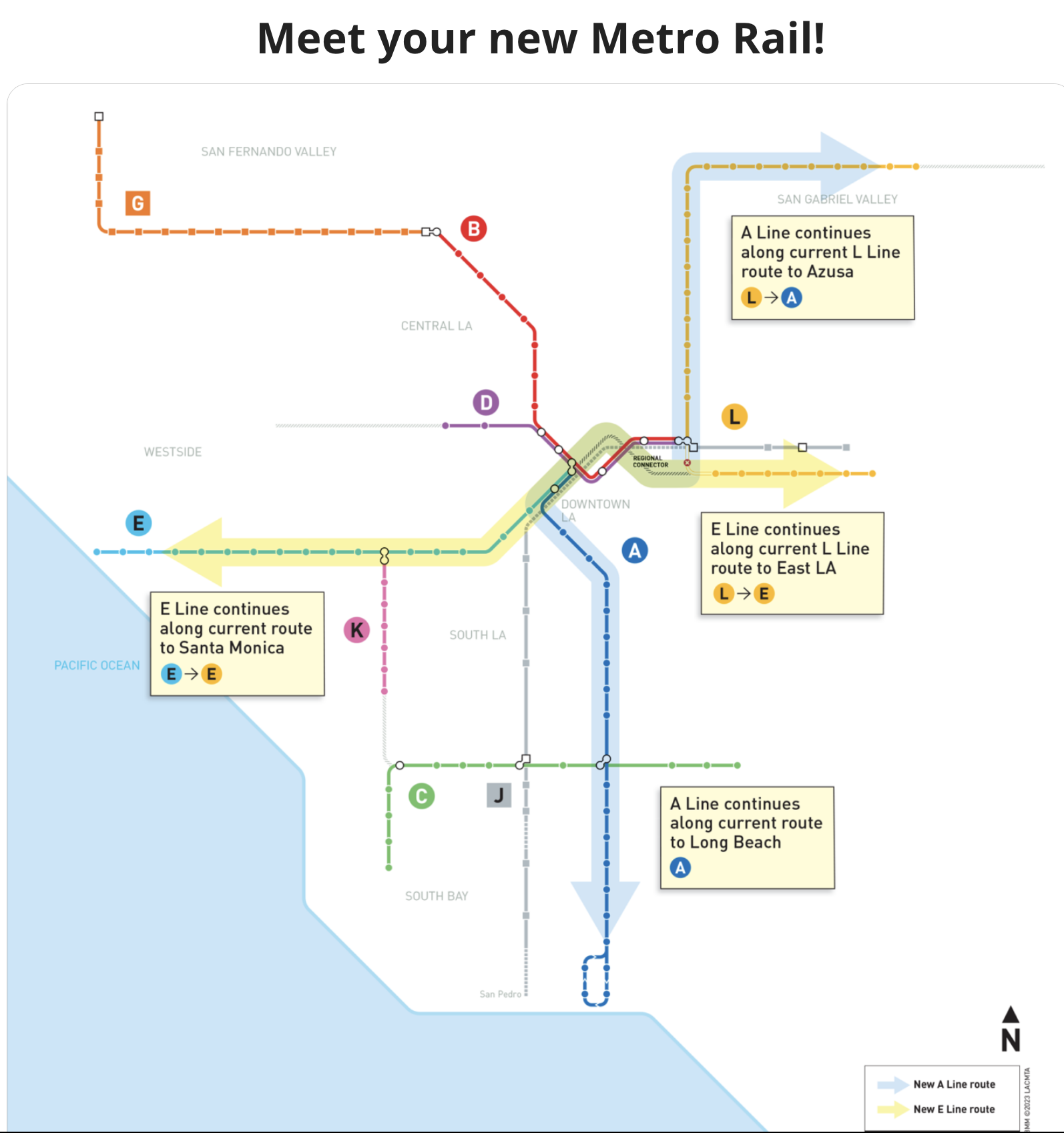
Los Angeles’s Regional Connector is open.  It’s a small piece of subway — less than two miles, with three stations, but it utterly transforms the rail network of Los Angeles, making trips across downtown much faster.  Here’s LA Metro’s quick diagram of the change:

It’s simple: In the network as it existed until this weeekend, light rail from north and east, called Line L, only came to the northeast edge of downtown, while the two lines from the south and west (Lines A and E) only came to the southwest edge. Traveling across the center thus required making two transfers, using the Line C & D Subway.  The Regional Connector rearranges these lines to that all services flow across downtown and out the far side. Much faster trips across downtown mean greater access to opportunity for many people across the city and beyond.

I’ve written before about the difficulty of getting regional focus on these core-city projects.  LA Metro did a good job with this one, starting by branding it the Regional Connector.  It may be in downtown Los Angeles but it’s not for downtown Los Angeles.  It’s for the entire region.

Does the History of a Technology Matter?

6a00d83454714d69e2012875c1a395970c-320wi

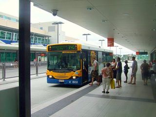
Mater Hill busway station, Brisbane

Ben Ross has a nice long read in Dissent about the history of Bus Rapid Transit, noting all the ways it’s succeeded, failed, and been co-opted by various non-transit agendas.  He’s especially interested in the way various petroleum-and-asphalt interest groups have supported BRT as an alternative to rail for reasons that probably don’t have much to do with their love of great public transit.  All this is worth reading and knowing about.

But what, exactly, should we do with this history?  Practically everything that breaks through into the public discourse has private public relations money behind it, and that money always has different goals than you and your city do.  That’s why you should always lean into the wind when reading tech media.  But just as it’s wrong to fall for everything you read in corporate press releases, it’s also wrong to reflexively fall against them.  (Cynicism, remember, is consent.)

Galileo paid the bills, in part, by helping the military aim cannonballs correctly.  Does that mean pacifists should resist his insight that Jupiter has moons?

So while I loved Ross’s tour of the history, I reject his dismissive conclusion:

Buses will always be an essential part of public transit. Upgrading them serves urbanism, the environment, and social equity. But a better bus is not a train, and bus rapid transit promoters lead astray when they pretend otherwise. At its worst, BRT can be a Trojan horse for highway building. Even at its best, it is a technocratic solution to a fundamentally political problem.

The term technocratic is really loaded here.  Given the new “revolt against experts” trend in our politics, we urgently need to recognize  hard-earned expertise and to distinguish it from elite selfishness, but technocrat is a slur designed to confuse the two.

6a00d83454714d69e2012875c19fc4970c-500pi

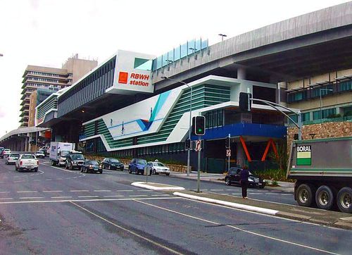
RBWH busway station, Brisbane

There are some great bus rapid transit systems out there, and not just in the developing world.  The mixed motives that underlie BRT advocacy don’t tell us anything about where BRT makes sense, any more than the mixed motives behind rail advocacy do.

A light reading of history can help you recognize the prejudices that may lay behind advocacy on all sides.  But then you have to set that aside, and think for yourself.


Portland: Frequent Bus Performance Approaching Light Rail’s

Here's an interesting chart:

Tri Met Ops Cost per Ride

This is a year's trend comparing bus and light rail (MAX) service in Portland's transit agency, TriMet, from the performance dashboard at the TriMet Transparency and Accountability Center webpage.  

The metric here is operating cost per boarding ride.  This is a good overall measure of how effectively a transit agency is liberating and moving people, where down means good.  (I prefer this ratio upside down: ridership per unit cost or "bang for buck," so that up means good. but this is obviously a chart by finance people who always want cost on top.)  This is a "macro" metric.  Practically everything a transit agency does affects it, so it's lousy diagnosis but not bad if you only have bandwidth to convey one measure.

Most American transit data just compares bus and rail, and inevitably shows bus performing worse.  You'll see that here too if you just look at the wide solid lines.  From this we get endless ignorant journalism lamenting the poor performance of the city bus, as though all city buses are basically alike.

What if we separated out highly useful and liberating bus service as a separate category?  That isn't exactly the distinction made here but it's close.  TriMet's Frequent Service network (still being restored, but mostly now back in existence) is the network of all services that are almost always coming soon.  

This chart says two remarkable things:

  • Frequent bus performance is now very close to light rail performance.   
  • The spread between Frequent Bus and infrequent bus is usually bigger than the spread between all buses and light rail.

The lesson is pretty clear:  The "city bus" is a misleading category, and the much-fetishized difference between bus and rail may matter less than whether the services are designed to be useful.  And when it comes to usefulness, no one variable capture that more than frequency.  

portland: the grid is 30 years old … thank a planner!

Thirty years ago next week, on Labor Day Weekend 1982, the role of public transit in Portland was utterly transformed in ways that everyone today takes for granted.  It was an epic struggle, one worth remembering and honoring.

I’m not talking about the MAX light rail (LRT) system, whose first line opened in 1986. I’m talking about the grid of frequent bus lines, without which MAX would have been inaccessible, and without which you would still be going into downtown Portland to travel between two points on the eastside.  (Full map here.)

Portland grid\

What did it look like before 1982?  Here’s a bit of the 1970 network (full map here).

Portland 1970

The 1970 network consisted of bus routes radiating from downtown across the gridded eastside, which constitutes about 3/4 of Portland.  If you were anywhere on this network, you had a direct bus downtown — a slow, circuitous, and infrequent bus.  Very few routes ran better than every 30 minutes during the day.  Only two routes ran north-south across the east side, and both were too infrequent to transfer to, so you couldn’t really use them unless both ends of your trip were on them.

How did the 1982 network transform the possibilities of mobility in the city?

  • The old network was solely about going downtown.  The new network was about going anywhere you wanted to go.
  • The old network was infrequent.  The new network required easy connections, so it was designed to run at high frequency (most lines every 15 minutes or better all day).  Remember: Frequency is freedom!
  • The old network was wasteful, as many overlapping lines converged on downtown.  The new network was efficient, with little overlap between lines, and with lines spaced further apart to the extent that the street network allowed.  This is how the resources were found to increase frequency so much.
  • The old network was complicated, with routes often zigzagging from one street to another.  The new network was simpler, easy to keep in your head.  Many streets that were formerly served by a patchwork of overlapping routes, such as Division, now had a single route from end to end, so that you needed only remember “the Division bus.”  Transit became an intrinsic part of the street.

If you’re in a hurry, skip to “Thank a Planner!” below.  But if you have a couple of minutes, let’s explore more deeply how the grid transformed Portland, and why it was so controversial at the time.

In both maps above, that wavy line across the middle of eastside Portland is the Banfield Freeway, where the first and backbone line of the MAX light rail system runs today.  In the 1970 image, look for the line marked “1” extending north from the Banfield in the middle of the image.  This is NE 42nd Avenue (a bit of which is labeled 41st, but don’t let that distract you).

In the old network the bus line along 42nd came from the north edge of the city, once an hour.  Partway down it merged with another branch, to form 30-minute frequency.  When it approached the Banfield, it turned west and zigzagged into the city via the Lloyd district.  Once it turned west off of 42nd, it was duplicating other routes the whole way.  If you wanted to go somewhere else on the eastside, the bus was not much use.   Frequencies were poor so it was very hard to make a trip involving multiple routes.

If you lived on NE 42nd in 1982, you were confronted with massive change, the sort of change that makes people scream.  Never again would you have a direct bus to downtown Portland.  Now you would be on the new 75, which would run continuously north-south all the way across the city.  And if you wanted to go downtown, you would have to transfer (as we called it in those days).

But on the bright side, the 75 would run every 15 minutes, so transfering wasn’t hard.  And in return, you got all the other benefits of a frequent routes that would let you connect quickly to reach destinations all over the east and north sides of the city, without going downtown.

This is always a tough sell, because many people value transit only for the commute downtown.  These people tend to complain when the network is optmized to serve many kinds of trip at once, which is exactly what the grid does.  A frequent grid is the ultimate in versatilityequity and freedom.  It does not pick favored destinations for favored markets. Instead, it delivers anywhere-to-anywhere mobility for wherever you might want to go.  Today, the non-downtown elements of the grid, especially 72 and 75, are among TriMet’s most productive lines.

The grid redefined the role of transit in serving Portland’s livability objectives.  When you think of everything that makes Portland both livable and culturally distinctive, you’re probably thinking about the historically dense and gridded part of the city.  This is where almost every cool urbanist outcome of the last 30 years — from food carts to bike lanes to office-over-retail — has sprouted and thrived most successfully. Rail gets all the press, but the MAX light rail line would not have worked without this grid to connect with it.  (The reverse is not true: the grid worked well for four years before the MAX line opened, though MAX was certainly an improvement that achieved further ridership payoffs.) As Gregory Thompson and Jeffrey Brown put it in a recent paper :

If the 1983 and 1986 restructurings had not happened, LRT would have been a competitor with the CBD-focused, poor quality parallel bus routes that already were there, and there would have been no high quality bus routes intersecting the LRT at right angles. Portland would have enjoyed much less patronage than it has since experienced on both its LRT and bus routes.

Where did all the money for the new high-frequency crosstown lines come from?  Removing duplication. Look again at the your ride on 1970’s route 1.  Once it turned west off of 42nd, it duplicated other routes the entire way into downtown.  Now look closely at the routes approaching downtown from further south in the old map.  They ran on so many closely-spaced parallel streets that they were effectively duplicating one another as well, wasting service.  The grid plan found many resources by removing these duplications and moving to wider and more consistent spacing of lines across the whole city.  In the same process,the grid introduced the idea that it’s OK to walk further to a more frequent and useful service — the foundation for transit’s link with walking (and with all of walking’s public health outcomes) today.

The grid was also a radical simplification, making it easier for people to keep the network map in their heads.  Now, bus lines would often follow the same street from end-to-end, so you could remember easily that there’s a Division Street bus, say, and an 82nd Avenue bus.  In the old network, if you wanted to go from 20th & Division to 82nd & Division, you had to go downtown and back, because these two parts of Division were covered by different routes.  The beauty of the grid is that your transit directions are sometimes as simply as walking or driving directions:  “Take the Division bus out to 82nd, then take the 82nd bus south.”  The transit lines are just part of the street.

Imagine, in 1982, the struggle involved in implementing this.  Vast numbers of people lost their direct bus to downtown, at a time when going downtown seemed like the only purpose of transit to many existing riders.  Transit agencies tend to listen most to their existing riders, who have adapted their lives to the system as it is, so it takes real courage for them to seek new markets instead of just catering to the existing ones.   Imagine the disruption, the rage, the recriminations, not to mention the apathy from people for whom buses just don’t matter, no matter what they’re achieving.

Thank a planner!

If you can imagine how hard this was, consider thanking the planners who took all this abuse and persisted in pushing the plan through, because they believed in everywhere-to-everywhere networks and knew this would work if it were tried.  I’m especially thinking of:

  • Ken Zatarain, who was a TriMet service planner at the time and who is still at the agency.  Thank him at:  ken dot zatarain at wsp.org.
  • Thomas G. Matoff, the single most important mentor in my own transit career, and probably the critical player in pushing the grid through.  Tom, who was service planning manager and thus Ken’s boss, was an eloquent, passionate and persistent advocate for the grid both inside and outside the agency.  He was the first person I’ve met, and one of the few I’ve known, who could convey how essential network design is to the life, joy, and prosperity of a city.  Tom went on to be General Manager of Sacramento Regional Transit and is now working on the Sonoma-Marin rail project in California.  Thank him at:  tmatoff at ltk dot org .

I’m dead serious:  If you value being able to get around Portland in all directions, thank them.  In other words, do one of these things:

  • shoot emails of appreciation to the three emails above, copied to me (jarrett AT jarrettwalker DOT net), with “Thanks for the grid” in the subject line, or
  • leave a comment here, or
  • say something on Twitter with the hashtag #PDXGrid .

You might also ask the two mayoral candidates about how important the frequent grid is to their vision of the city, and whether they think it should be enhanced.

Why does this matter?  Because even today, there’s disagreement in Portland about important the frequent grid is, or even whether a complete everywhere-to-everywhere network (which requires high-frequency buses as well as rail) should be a priority at all.  Some view the grid as unimportant, for example, because they view bus service as unimportant.

Purists might argue that the grid never made it to its 30th birthday, but rather perished at 27 in 2009.  That was the year that TriMet cut all-day frequencies below the 15-minute threshhold that is widely accepted as the definition of “frequent enough that you can use it spontaneously, without building your life around the timetable.”  Since the grid relies on easy connections to achieve its goal of easy anywhere-to-anywhere access, the 2009 cuts began to undermine the whole idea of the grid. TriMet avoided doing this in its first round of cutting after the crash, but felt it had no alternative in the second 2009 round.

Will the grid ever be restored to its necessary frequency?  Will it ever be expanded and enriched (as regional land use planning generally assumes it must be) with even better frequencies?  Not everyone in Portland thinks this is a priority, so you might want to express your view.

More on the history and spectacular outcomes of the grid if you click below.  But even if you don’t click, thank a planner!

Continue Reading →
toronto and sydney: triumphs for network planning, not just light rail

Breakthrough news on rail battles in both Toronto and Sydney, both of which I posted on recently (Toronto, Sydney).  

  • Sydney's state government has made it official.  The one-way loop of the Sydney Monorail, designed to decorate the tourism-convention playground of Darling Harbour without being very useful to anyone, is to be torn down.  While the decision is being described as a move toward light rail — plans for which are definitely moving forward — it's really just a decision to invest in transit lines that do useful things — such as running in both directions, running efficiently enough to justify reasonable fares, and connecting with many other services so that people can go where they want to go, not just where you want to take them. 
  • Toronto City Council has definitely scrapped Mayor Rob Ford's plans to spend all of the city's transit resources on a few expensive outer-suburban subway segments designed to serve small parts of the region.  The move opens the way to move forward on more cost-effective light rail projects that will enrich mobility across the entire city.

Toronto transit commentator Steve Munro makes an important point, which could also be said of Sydney:

This is an important day for Toronto.  We are on track for a [light rail]-based plan and for a more detailed evaluation of our transit future than we have seen for decades.  Talking about one line at once, about fundraising for one project at once, is no longer an accepted way of building the city.  

That's the key.  The Sydney Monorail failed because it was "one line at once" — a project conceived in isolation with no interest in being part of a complete network.  And in Toronto, a city with numerous desperate rapid-transit needs, planning will no longer pit neighborhoods against each other to the degree that Mayor Ford wanted to do.  Instead, Toronto can move forward on projects that fit together into a more complete rapid-transit grid — serving "anywhere to anywhere" trips.

Finally, a warning to technophiles!!  Technophile commenters will doubtless chalk this up the Sydney decision as a defeat for monorails in general.  I disagree.  It's a defeat for one-way loops, poor connectivity, and symbolic as opposed to actual mobility.  The monorail didn't fail just because it was a monorail, but because it was a poorly designed line.  Likewise, the Toronto outcome isn't a victory for light rail or a defeat for subways, but merely a commitment to better network design.

one-way splits as symbolic transit

 Now and then I see a professional study of a transit line — often light rail or streetcar — that suggests that the two directions of service should be a little bit apart from each other, say on different streets, so that they "cover more area."

This is the clearest and simplest example I've seen of the conflict between symbolic transit and actual transit.  If you are creating transit for symbolic purposes — say, to give the appearance of permanent mobility so as to stimulate development, then it's certainly true that separating the two directions, so that rails and stops appear on two streets instead of one, will spread that appearance over a larger area.

However, if you care about people getting where they're going, the one-way split reduces the area served by a transit line.  That's because for a two-way line to be useful, you have to be able to walk to both directions of a service.  The further apart the two directions are, the smaller the area (light blue) that will have a reasonable walk to both of them.


One way split

If you're wondering whether a project is about getting people where they're going or just appearing to do so, the handling of one-way splits is often a clue. 

Obviously, one-way splits for transit are often required by a one-way street pattern, but even in these cases, when we're planning for both legibility and ease of use, planners sometimes suggest combining the two directions on one street.  This can be done by giving transit a lane that allows it to travel against the main traffic direction (called a contraflow lane), so that although traffic is split between two streets all transit is on one.  That maximizes the area actually covered by the line, but of course, it may reduce the area that has symbols of being covered! 

paris: did rail worsen freeway congestion?

Can transit projects be judged based on the "welfare" of various user groups?

IMG_0771 If you know how to equate the "welfare" of a transit rider with the "welfare" of a motorist, and are not concerned with any other forms of welfare, you can do a calculation that appears to say whether a transit project was a good idea.  

From a new paper in World Transit Research by Rémy Prud'homme. 

In Paris, an old bus line on the Maréchaux Boulevards has been replaced by a modern tramway [the T3, opened in December 2006]. Simultaneously, the road-space has been narrowed by about a third. A survey of 1000 users of the tramway shows that the tramway hardly generated any shift from private cars towards public transit mode. However, it did generate important intra-mode [shifts]: from bus and subway towards tramway, and from Maréchaux boulevards towards the Périphérique (the Paris ring road) for cars. 

… The welfare gains made by public transport users are more than compensated by the time losses of the motorists, and in particular, by the additional cost of road congestion on the Périphérique. The same conclusion applies with regard to CO2 emissions: the reductions caused by the replacement of buses and the elimination of a few cars trips are less important than the increased pollution caused by the lengthening of the automobile trips and increased congestion on the ring road. Even if one ignores the initial investment of 350 M€, the social impact of the project, as measured by its net present value is negative. This is especially true for suburbanites. The inhabitants (and electors) of Paris pocket the main part of the benefits while supporting a fraction of the costs.

So here is our plate of facts:

  • On series of boulevards running parallel to the Périphérique, the motorway that circles Paris, traffic lanes were removed and a light rail line was added.  This was done less than five years ago.
  • The light rail line didn't attract new riders beyond those already on the bus and subway systems.
  • The closure of traffic lanes caused traffic to shift from the boulevards to the motorway, increasing congestion on the motorway, therefore affecting many motorists traveling long distances around the edges of the city. .
  • As a result, the benefits tended to fall heavily within Paris, among public transit patrons on affected boulevards, while the disbenefits fell on suburban motorists.

All that may be true.  Does this mean the rail line was a mistake?  Discuss.

vancouver: new round of broadway line options

The planning for the missing link in Vancouver's transit network has taken the next step. Newly refined options are out for public comment.  The corridor corresponds, at least in its endpoints, to the orange line on this map, where the existing Line 99 runs one of the most frequent and crowded bus corridors in the west.

VancouverGrid(2) The west end is the University of British Columbia (UBC).  The east end is Commercial/Broadway station, the main transit gateway to the entire eastern two thirds of the region.  In the middle is Vancouver's second downtown, Central Broadway, which includes City Hall and the main hospital, as well as a station on the Canada Line to the airport and the southern suburbs.  (Skytrain and the Canada Line form the region's driverless rapid transit network.)  It's hard to overestimate how central this corridor is not just to the city, but to the region.  For example, many trips between southern suburbs and northeastern ones (Richmond to northern Burnaby say, or Coquitlam to the airport) will be made much easier, or not, depending on this project's outcome.

The newly refined options include rapid-transit options (widely presumed to be extensions of the Skytrain Millennium Line) either to UBC or possibly just to Arbutus Street, which makes sense to consider because it's the end of the dense or densifiable portion of Broadway, and completes all of the regional-connection needs except for UBC itself.  They also look at light rail options and Bus Rapid Transit, both of which would need an exclusive lane.  Light rail options are suggested both on Broadway and also veering off onto an alignment closer to False Creek, feeding into Great Northern Way.

It looks like an interesting process, one that will impact the transit mobility options for a vast part of greater Vancouver.

Basics: Expertise vs. Activism

The planning professions work in a grey zone between expertise and activism, and managing these competing impulses is one of our hardest tasks.

As a transit planning consultant, I don’t worry much about being perceived as an advocate of transit in general.  Experts in any field are expected to believe in its importance.  But I do try to keep a little distance between my knowledge about transit and the impulse to say “You should do this.”  A good consultant must know how to marry their own knowledge to their client’s values, which may lead them to make different recommendations than they would do as a citizen, expressing their own values.

Often, I use this blog and its comments to refine my own thinking about transit in the abstract.  This is part of how I cultivate my own expertise, but it is easy to mistake what I say for activism.  When I say, for example, that some of the widespread claims about the superiority of rail over buses are cultural feedback effects, I’m not thinking like an activist or advocate; I’m thinking theoretically, like a philosopher.  To me, this is a crucial skill for a consultant who’s going to have to marry his client’s values with his own expertise.

Philosophical or scientific training attunes you to the difference between prescription (telling people what they should do) and description (describing reality as it appears to be).  In their purest form, prescription is the job of ethics, while description the job of science and metaphysics.  A great deal of human speech, especially political speech, is a mixture of description and prescription, often one pretending to be the other.

In the planning world, prescription is the job of citizens, leaders, and advocates, while description is the work of professional experts like me.  Obviously, this has to be a conversation.  The expert has to ask the community to clarify its values based on the actual tradeoffs presented by reality, and the community has to respond.  And as that goes on, both sides need to be clear about their roles, and respect the role of the other.

Partly because of my science and philosophy training, I tend to police the prescription-description boundary in my own thinking, and dwell in the space of pure description more than many people do — certainly more than most activists do.  A lot of regular readers of HT share that training and that inclination, and some don’t.

For a critique of the futility of living your whole life in this descriptive mode, watching and describing the world but never doing anything, see Shakespeare’s Hamlet.  But the opposite is also futile.  An ethical system devoid of curiosity about objective reality devolves into pure egotism.  Tyrants — whether they lead a nation or an office clique — are people who sift reality and see only what suits their ethical narrative (which, at that point, is really an egotistical narrative) and who forge echo chambers of people who help each other do that.  At the core of the tyrant’s stance is a childlike egotistical wail: “Why doesn’t everyone do as I say?  I see so clearly what needs to be done!”

And yes, everyone has an inner tyrant, including me.  I try to describe that tendency in myself, so that while it will always be in the room of my mind it’s not usually able to set the room on fire.  In fact, that’s exactly why I’m so careful about not letting my descriptive thinking turn too quickly into prescriptions.

Streetcars, for example.  Nowhere in this blog have I said that cities shouldn’t build streetcars if they are sure that they want streetcars.  Some streetcar advocates hear me saying that because they are dividing the world into pro-streetcar and anti-streetcar camps, and I’ve said things about streetcars that don’t sound like enthusiastic advocacy.  I’ve made some descriptive observations about problems raised by the American streetcar revival movement, and I’ve also noticed situations in which streetcars are inferior to buses in their ability to actually get you where you’re going, like this one:

Car blocking streetcars

I would like people to know about these issues so that they make better decisions about what to advocate and why.  That doesn’t mean I want them to decide not to build streetcars, but it may mean, for example, that in deciding whether to support a streetcar, you might need to care about whether it will be in mixed traffic.  It may also mean being very clear, when you’re advocating a streetcar, that you’re not getting anything faster or more reliable than a bus can be.  Again, I say this not because I think cities should or shouldn’t be building streetcars, but because you shouldn’t be deluded about what you’re buying, and what purposes it will really serve.

I have vivid memories of San Francisco Transportation Authority meetings in the early 1990s when the Third Street light rail was under debate.  Activists from the neighborhood had turned out in droves to support the line, but when you actually listened to their testimony, some were talking about “we need rapid transit,” while others were saying “we need rail to stop in every block where it will strengthen our businesses.”  I knew, as an expert, that while this whole crowd appeared to be on the same side of the issue at hand, half of them were not going to get what they thought they were advocating.  They were not going to get a project that served their values.

I may also point out that if you think purely about “extending your rail network” as though your bus network is irrelevant, you can do serious damage to your existing transit system.  For example, in a high-frequency grid, if you break one line of the grid into three consecutive pieces because you want rail in the middle but buses on the extremeties, you may suddenly force many new connections to a degree that could quite possibly will reduce the overall level of mobility in the city.   That thought is relevant, for example, to several cities’ streetcar plans, and to the Crenshaw light rail line in Los Angeles, and to the Gold Coast light rail line (at least its first phase) in Australia.

And yet, sometimes I do sound like an advocate — about transit in general, about protecting transit from traffic, and about congestion pricing.  Am I just falling off the wagon when I say those things?

Well, all scientists (by which I mean broadly “people who try to describe without prescribing”) have this problem.  Sometimes the scientific work of description discovers that something needs to be done if we want to survive and prosper:  Banning DDT, addressing carbon emissions, correcting perverse pricing signals, even building a transit line.  If you’ve followed any of the conversation around climate change, you know how uncomfortable trained scientists can be when they’re required to speak prescriptively.  Their credibility (not just to their profession but also to themselves) has depended precisely on not doing that.  It’s like telling a recovering alcoholic that after all the disciplined work of recovery he’s done, the future of humanity now requires that they start drinking again, just a little.

All I can say is that I feel that discomfort and try to manage it, by marking, as clearly as I can, when I’m prescribing and when I’m describing.  And there are also issues (like climate change) where, quite frankly, practically all experts seem to know what needs to be done to achieve the outcomes that everyone seems to want.  I feel that way about congestion pricing.  It’s just not that hard to explain, to a reasonable person who’s familiar with the idea of supply and demand, that as a motorist you are going to pay for scarce road space in either time or money, and that it’s not unreasonable for some people to choose to spend money to save time.

I do what I can to distinguish between description and prescription when I’m writing.  But frankly, we all need to do the same work when listening.  If your first contact with transit politics is in the context of a fight about whether or not to build a particular rail line, you’re going to hear prescriptive voices on both sides, citing data that’s been selected to match their point of view.  You’re also going to hear descriptive voices treated as prescriptive — which is how some streetcar advocates perceive my comments about streetcars.  One of the most basic disciplines that you can cultivate, as an advocate or leader, is to try to hear descriptive information as descriptive.  This may require you to consciously suppress or bracket the emotional reaction you have, as an advocate, when you first hear it.

Really, none of what I’ve written about streetcars is about streetcars, except insofar as the American streetcar revival movement is a excellent example of a descriptive point that seems important to me.  The point is that “it’s possible to spend a lot of money on transit lines that don’t improve anyone’s mobility.”  I’m not saying you shouldn’t do that.  I am saying that before you that, you should understand this point, so that you’re sure that the line you support does what you want it to do.

That’s what responsible experts do: they help you implement your values.

edmonton: strasbourg of the prairie?

A Guest Post by David Marlor

David Marlor was raised in the UK and is currently a regional planning manager working on the coast of British Columbia, Canada in a coastal rural setting.  He holds a planning degree from the School of Community and Regional Planning at UBC, where his thesis was on an integrated approach to transportation planning in the lower mainland.

Chinese_Arch_1
In the past couple of years, led by Bob Boutilier (general manager of transportation) the City has been planning the expansion of the LRT using low-floor technology.  Edmonton is credited with leading in transit innovation twice in the past. In the mid-1960s, transit superintendent Don MacDonald introduced an early version of a hub and spoke [or pulse] transit system. This is still widely used in Edmonton and in many other North American cities. The second was the introduction of the modern LRT to North America in 1978.

What’s different about the current LRT plans in Edmonton is that instead of fast LRT trains moving commuters from suburbs to the city, the LRT will be a European style system, still in its own right of way, but with stops closer together, smaller and more intimate with the community, low floor vehicles and replacing car lanes with LRT lanes. That last is a paradigm shift for Edmonton.  LRT up until now has been about building it without removing road capacity for private automobiles. The new LRT lines, the cost of which is currently pegged at about Cdn$3.4 billion, will see extension of the existing high-floor system to the north-west north-east and south as demand warrants, but the lines will fit the community better than before.

The approved plans includes a completely new low-floor network running on the street, even in the city centre. It is a system designed to support future TOD at the stations, to encourage higher densities. Unlike the existing system, only five stations on the proposed 29 station low floor line have bus stations attached to them and only two have park and ride facilities, both adjacent to freeways. This is about shaping the city, not moving commuters from the suburbs to the city (although that is part of it, it is not the focus).  The plan includes future low-floor line linking the downtown with the Old Strathcona business district on the Southside of the river and a line out to the eastern suburbs.

In fact, the proposed the proposed Edmonton system may remind some readers of Strasbourg. Like Strasbourg, Edmonton is envisioning completely remodeling the streets the trams run on – in many cases removing lanes of traffic, restricting turn movements, closing or redesigning intersections, and where possible, widening and improving the pedestrian infrastructure. Like Strasbourg, the stations (stops) will be located every 3-4 blocks (300-400 metres) in the city centre and further apart outside the core. The aim is around every 800 m, but in reality the stops will be placed at convenient nodes or logical locations that best fit the fabric of the city.

The City of Edmonton website has extensive information, including design details, routing, and illustrations. Unfortunately, the project is not funded yet, but City Council and the Mayor are keen to see it happen and want to get it built in the next 6-8 years. The plans are ambitious, and it's exciting to see a car-oriented oil producing city like Edmonton be thinking and supportive of this direction.

Illustration: Simulated image by City of Edmonton