Paris

Paris: The Triumph of the Bus Stop

Do you think bus service is never as “permanent” as rail service?  Well, it depends on how much infrastructure you build, and how proudly it announces the bus service as an essential part of the cityscape, both as icon and as opportunity.

Each time I visit Paris there’s something new in its public transit, but these new bus stop signs, now standard across the city, are remarkable.

img_1190

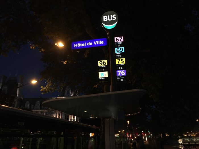
They’re around 4m (12 ft) high, towering over the bus shelter to which they’re attached.  At night they are the most prominent informational icons in the streetscape, by an order of magnitude.

Look closer:

Version 2

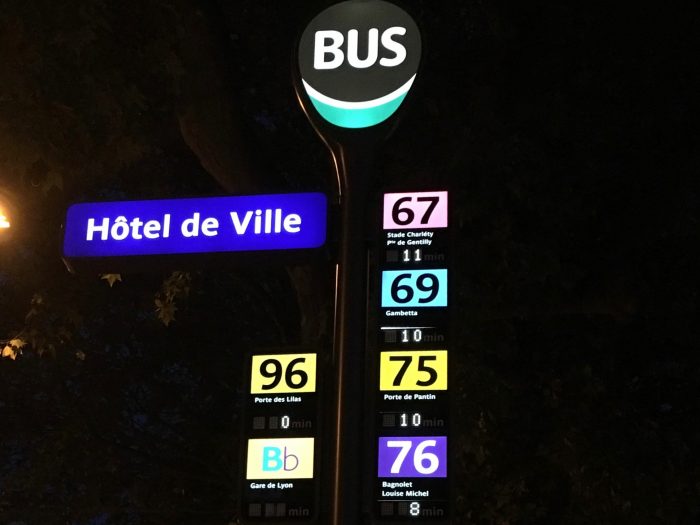
Every stop has a name, reaffirming your sense of your place in the city.  (At night, these are actually the easiest locational signs to read, so they have navigational value extending beyond transit.)  For each route, there’s the number, the endpoint (indicating direction of travel) and the number of minutes until the next bus arrives.  If you know the network, you don’t even have to look down to know where you are, and when the next bus is coming.

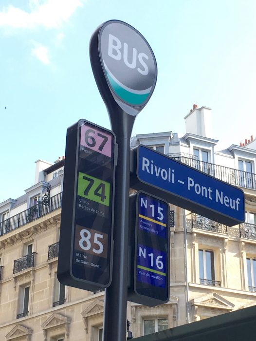
Here’s one in the daytime, when the little realtime displays are harder to catch in a photo.

img_1045

I don’t have a good pic of the entire shelter, but it has everything you’d expect of a rail stop, including maps of each route, a diagram of the bus network, a diagram of the metro and regional rail network, and timetable and fare information.  It also has more extensive realtime information displays, showing the next several buses departing.

On the other hand, it doesn’t have the extraneous things that my architecture and built-environment friends often suggest, such as distinctive architectural designs or “community hub” features like coffee vending or (yes) lending libraries — all of which have been explored.  A big city needs lots of bus stops, so the ideas that matter are the ones that scale.  In any case, the more you respect your bus system, the more you can celebrate it for what it is, rather than expecting it to entertain us in ways that distract from the liberty it provides.

When I lived in Paris in 1986, the buses and bus shelters were like what most Americans are used to: basic, functional, but sometimes dirty and poorly maintained.  It was presumed, back then, that the Metro and regional rail systems were the serious transit, and that the buses didn’t matter much, and the infrastructure reinforced that message.

All that has changed.  Buses are so nice that you can scarcely distinguish them from trams (streetcars).  Many streets have car-free lanes that buses can use.  Now, with these pillars of information, bus stops are even easier to find than metro stations, and almost as easy to navigate.

There are several principles at work here:

  • The more subways you have, the more surface transit you need.  This excellent bus system operates right on top of the world’s densest metro network (in terms of stations/sq km).  Almost everyone in Paris is near a metro station, but there are still plenty of markets (short trips, trips along paths not followed by metro) where surface transit is the right tool.
  • Unless you already have streetcar tracks everywhere, the only surface transit that can cover your whole city, soon, is bus service.
  • So if you want an effective transit system for everyone, you have to convey that the bus system matters, through network design, branding, and infrastructure.
  • The order is important.  First get the network design right, then develop branding that works with the network design.  Finally, conceive infrastructure that serves and celebrates both.

I could quibble with Paris on that last point.  As with most bus networks, Paris’s seems to be more complex than it needs to be, though a modest simplification is underway, as you can see by playing the map here* .  The signage doesn’t help us distinguish major routes from minor ones.  Imagine the extreme transparency that would arise from fusing Paris’s level of bus signage with Barcelona’s commitment to extreme simplicity and legibility in network design.

But the big point is this:  Buses can be as liberating and efficient as your city wants them to be.  The more efficient and liberating they are, the more they deserve to be celebrated in infrastructure.  The bus stop is one of the biggest signals, to everyone in the city, about the community’s attitude toward buses and their customers.


* At this page, you can move the map left or right to see the changes.  The current network is on the left, the proposed one on the right.  It’s simpler but not that much simpler, and it still doesn’t help you distinguish major routes (high frequency, long duration) from minor ones (lower frequency, short duration).

looking for structure: the metro maps of Jug Cerovic

Paris-based Serbian designer Jug Cerovic tipped me off a month ago to his remarkable work on subway maps, collected at his website and since hailed at Atlantic Citylab.    If you want to geek out on beautiful detail, go to his website now.  Here, I'm interested in looking from a fuzzier distance.


Moscow-metro-subway-map-1000

His work interests me because I'm always trying to help people see underlying principles of network structure, such as the high-frequency grid in all its forms, and often contending with the seductive allure of its opposite, the seemingly endless loop.  

Cerovic's eye has picked out these forms, and fondles their contrast expertly:  He picks out a central loop in every city that provides a hint of one, organizing map after map around a geometrically perfect circle or oval.   Berlin:

Berlin-metro-subway-u-bahn-map-1000

His maps of comprehensive East Asian metros call out the circle line in most of them.  Beijing and Shanghai are both rigidly circle-and-spoke like Moscow, but Beijing's outer circle is far enough out to create orthogonal grid effects in relation to the straight lines it crosses.  Cerovic, perhaps sensing this, renders the loops as rectangles:

Beijing-metro-subway-map-1000

But it's hard to resist the beauty of the circle.  Tackling Paris, Cerovic seizes on the ellipsoid loop formed by Metro lines 2 and 6, rendering them as a perfect circle that seems to unify the image.  Only the color change signals that you can't go around forever.

Paris-plan-metro-subway-map-1000

I have long argued that the Paris metro is mostly an orthogonal grid system, with most routes in north-south or east-west paths that intersect to form logical L-shaped travel opportunities.  In fact, it's a great example of a grid system fitted to a gridless city.  Lines 2 and 6, and the more recent T3 tram that Cerovic renders as a quarter-circle, are really the only predominantly arc elements and even they function like east-west grid elements in the actual geography, 

In Madrid, Cerovic reveals the Expressionist quality of the metro network:  lots of emotive scribbles and personality quirks but without a clear structuring idea.  

Madrid-metro-subway-map-1000

The gently collapsed loop at the center reminds me of a Jean Arp sculpture.

In London, he ignores the obviously potential of the Circle Line, which despite its new tadpole shape could easily have been made into a perfect circle or oval.   Instead, the perfect circle that anchors his map is an emerging, ghostly London Overground, bristling with spurs:

London-metro-subway-tube-map-1000

I like Cerovic's maps for their stripped-down emphasis on the drama of line vs. loop.  Lines are from Mars and loops are from Venus.  They will never understand each other.  The challenge — in all the dimensions of design — is in making them dance, and helping both impulses succeed.


guest post: a san franciscan on parisian street design

Following up on my praise of the bus lanes of Paris, San Francisco reader Ian Leighton logs these observations about the operation of Parisian boulevards from several points of view. Ian is a co-founder of Embark, a firm that designs mobile applications for transit systems around the US and London. 

In addition to Métro / Bus / Tram / RER, I also walked (bien sûr) and made use of the bicycle sharing system Velib', so I was able to experience the use of street space in Paris from the perspective of several modes.

The buses work pretty well, and seem to be well-ridden. They connect quartiers that the metro doesn't and (in my case) allow for enjoyment of the city at street level, for better geographical education of how things are connected in the non-gridded city. I found I took buses much more often when the weather was beautiful.

About bus boarding: The normal length buses seem to still insist that you board at the front, which is still relatively quick, as I also observed in London, since most people have Navigo smart cards. They even have two "lanes" for boarding through the front door, with a divider and Navigo reader on each side. You can still pay in cash/coin with a hefty surcharge. The articulated buses allow all-door boarding as you observed, which is how the trams operate, convergently. Buses, in general, feel very modern and welcoming. As far as I could tell, there was no "old bus" vs "new bus" as we have [in North America] often, and all the buses treated riders like citizens. Low floor, line maps inside, upcoming stop displays, clean interiors, consistent branding and appearance.

Paris has seemingly done a good job of managing its street space, and it is dynamic both in daily use and over time.  The city seems to constantly make small modifications to its streets.  In daily use, the (wide, separated) bus lane also serves bikes and sometimes deliveries. Depending on the width of the bus lane, these are sometimes clever parking/delivery spaces cut halfway into the sidewalk that still let the buses squeeze by, sometimes not. Sometimes deliveries are prohibited during peak hours, when traffic isn't free-flowing enough for the bus to use a travel lane. On less wide streets, a non-separated bus lane is narrower and really mostly used by bikes, and by buses when the other lanes are truly blocked up with traffic.
Bus lane livraison Ian Leighton
The bus lanes are a great addition to the bike network. Bike lanes can get a little creative, transitioning from sidewalk to street to bus lane to across the street to disappearing. But even around giant intersections like Place d'Italie (13th), they guide you decently well around the craziness with sharrows and bike traffic lights. And you always have the option (and in some places, like Bastille and Concorde, it's the only option) to just, well have at it with the scooters, cars, trucks and buses in the fray — which isn't nearly as bad as it seems, since Parisian drivers are pretty considerate and aware of people on bikes.

On a longer-term basis, the city seems willing to make changes: converting its "payant" parking spaces into auto'lib stations, livrasion spaces, and dedicated bike lanes as well. It definitely feels like if you come back to the same street in a few years, there will undoubtedly be some slight modifications.

One thing that struck me was there there is still a ton of parking on Parisian streets! It seems that if you give a Parisian car-owner (or politician, planner, decision-maker?) the choice between removing a parking lane or a travel lane, they'll prefer the latter, and preserve their parking.

Caveat: traffic is still a problem. During rush hour, taxis and right turns can clog a bus lane pretty quickly. There doesn't seem to be the same gridlock law as we have in California. The effective lanes during the afternoon rush hour, in the 9th, 10th, and 18th (N / NW) end of Paris at least, where I observed them, suddenly have a line of taxis and buses. This is usually okay for bikes, but occasionally it gets bad enough that bikes have to do some weaving through the lines of taxis. A little improvement is still needed, as always.

These photos were taken during rush hour on rue Lafayette in the 10th. There was so much gridlock, and so many taxis in the bus lane, that 5 or 6 buses were stuck in line with the taxis, between two bus stops. I don't recall whether any were bunched on the same route.
Weaving Taxis2
Bus lane traffic
Coming back to San Francisco, I bike a lot more, since it's so much faster than transit. Being in Paris has made me realize the potential to have a great bus system (barring the full-scale metro, or even Parisian style tramway, we doubtless need in a few corridors and can't pay for). Removing stops, contraflow and separated (or at least colored) bus lanes to signal to drivers that they're not supposed to be there, and signal priority would doubtless do a lot to speed up MUNI. It even seems, to me at least, that the Muni Metro T line doesn't even have signal priority, even with its own right-of-way… or if it is, it's pretty ineffective. Oh well, I'll have to wait for the San Francsico Transit Effectiveness Project, someday.  

paris: “the bus stop of the future”

Now that Paris has bus lanes on almost every boulevard, we can expect their transit agencies to continue investing and innovating around their frequent and popular bus services.  Today we get "the bus stop of the future," where designer Marc Aurel has packed in every convenience that will fit in the space, plus a few more.

Paris station de bus du futur 1
Paris station de bus du futur


Yes, it's still a bus shelter, but the idea is to make it both more useful and more of a social space.  People may come here for a range of things other than catching the bus, so that social interaction and the life of the street intermix with waiting to produce a more vibrant, interesting, and safe environment.  It's the same principle by which transferring passengers can help activate civic squaresFrom Bati-journal (my rough translation):

This experimental station at boulevard Diderot is not just a place to wait for a bus. Covering an area of ​​80 m2, it was designed as a multi-purpose public space … .  Here you can buy a bus ticket, get information about the neighborhood, have a coffee, borrow a book, play music, recharge a phone, buy a meal to take away, rent an electric bike, stay warm while eating a sandwich, or set up a bag on a shelf to do your makeup.  Variable light adjusts for day and night conditions. This project will also be the first urban test of materials and technological innovations … such as ceramic furniture invented by Marc Aurel, and a sound design integrated into the fabric of furniture …

I'm disappointed they didn't include an art gallery with some durable lendings from the Louvre, on the model of Louvre-Rivoli station

But seriously:  This is what a major bus stop or station might look like if you really, really valued buses, and also value the principle that uses of the street should be intermixed so that they contribute activation, interest, and safety to one another. 

guest post: the transport challenger (by adham fisher)

Adam-fisher-metroHere's a fun weekend read, by British transit-marathon champion Adham Fisher, shown at right in the process of conquering Madrid.  You know you love your transit system when your community can honor exploits such as his.


I admire rail fans. Though I am sure that other nations have people who yearn after trains, I almost consider it a typically British pastime. Individuals take a day out to descend on a station where they know lots of weird and wonderful trains will pass. Notebooks in hand, they write down the numbers; cameras on tripods, they take photographs of the carriages, and a different train in an unusual location is always a bonus. At these platform picnics can be a good social atmosphere. And the amount of knowledge rail fans have is astonishing. But I don’t like public transport to that extent. I wouldn’t want to stay in one place all day documenting things. I like to move.

Rail magazines here might deal a lot with main line intercity and heritage trains. But I like city trains, specifically urban rapid transit. I try to go around underground rail networks as quickly as possible in one day, visiting every station. There is actually an official Guinness World Record for doing so on the London Underground – currently 16 hours, 29 minutes, 13 seconds – which I have attempted 11 times, often completing the system but not touching the record. I have also undertaken similar challenges on buses and trams.

This is not easy. Notebooks are required for this exercise to write the route down station by station, the arrival and departure times at/from each and the operating numbers of the trains. Cameras are required to take photographs of every station. Every so often, a challenger must ask a generous member of the public to sign a witness statement, saying they were where they say they were. Basic fitness is useful; if one wants to travel as quickly as possible, they must run when they transfer. Just one train missed could mess up the schedule entirely. Running is not restricted to stations, and neither are the participants. Guinness rules allow running or the use of other scheduled public transport to travel out of the system between adjacent stations, which can save time; the train need only arrive at or depart from the station for it to count. It is physically and mentally demanding, being up extremely early, probably not going to bed until very late, with no guarantee of success due to service delays, line suspensions and signal failures which can occur any time of any day, as regular commuters know. One of these can mean the end of an attempt if it slows you down enough and prevents you going further. And the average commuter who hates the Tube and tries to spend not one single second longer on it than absolutely necessary, will surely ask: why? Why would you want to waste a whole day underground doing something that pointless?

Admittedly, I’m not quite sure. After all, public transport is merely a mundane and functional thing, no? Designed to ferry people from home to work, A to B, and nothing else. But the beauty of something like this is that I can make the ordinary extraordinary. I can buy a travelcard and the amount of single journeys I make per attempt add up to many times that cost. An unorthodox exploitation of the system. I have been greeted with incredulity and called eccentric by some for doing what I do. Of course, it is not a normal activity; I admit that straight away. But neither is climbing a mountain. Mountains are in far away places with treacherous terrain and tangible danger. People climb mountains because they are there, and the same reasoning applies to those who choose to make much more out of something ordinary on their doorstep. Mountain climbs are many times more demanding, and I don’t think I could do one; I would rather spend several hours underground on trains than eight miles up Everest in temperatures well below freezing and extremely thin air. 

No other official world record is considered for traversing a transit system apart from in New York, so the fact I have performed the feat in other cities will no doubt seem even more pointless. Having attempted the London record several times without success, I began to look at other maps, realising it could be even better to plan a route around a system where perhaps few people might have done the same. With a wealth of European metros just across the Channel, I have visited every station in cities including Paris, Madrid, Brussels, Amsterdam, Rotterdam and Lille. The challenges are worthwhile when completed, but being recognised for it is also a major bonus. I have been interviewed on radio, been the subject of a museum story, but the best reaction was to my first attempt out of Europe, on the Chicago L. I told one or two people I was doing it and was asked to contribute to the main CTA blog. It became perhaps the most debated story of 2011 in the comments section. A while later, three students read about what I had done and tried to do the same thing, but were slightly slower. Articles were written about them and my name started to be dropped as the “record holder”.

Fisher L 3Next thing I know, I am contacted by the CTA to be informed its President, Forrest Claypool, wants to write to me personally. Which he does, also sending me a special Chicago-styled station sign with my name on. Such recognition is, in many ways, better than a world record. Has any other transport authority honoured an individual for riding its system to extremes? No Guinness certificate but I can joke about having a station named after me.

Paris yielded another special run, and led to my other public transport project. At the same time as planning the excursion, I happened to be writing a song with my friend Annanem called Métro, which listed every station in alphabetical order. I was being discussed and thought that if we finished the song in time, it could be another promotional tool. So we put it on YouTube the week before I went out. A short clip was played on French radio to accompany an interview I gave them.

Metro EP coverAfterwards, I thought of returning to Paris to play the song live, having been told it was very off the wall. Only having the one tune and hoping to secure a gig, I asked several people if they would like to write songs, poetry, anything, about a rapid transit system of their choice. Enough material was submitted for an album, which I compiled and called the Metro EP (cover at left). All artists were given the collective name 1000 Stations.


Metro LiveI and two other contributors launched the album in Paris, playing it in an arts venue and also giving out CDs to a few people on the Metro, explaining what it was about. We have just played the first UK gig with the project and hope to release it very soon.

That is an example of public transport creativity. An album was born out of my tendency to use public transport in an unorthodox fashion, which I think itself is a bit creative – devising the potentially quickest way to go around a rail network, poring over maps, plans and timetables, making transfers that would seem silly to a local. And it’s incredibly exciting to do, especially when you don’t even know the city. I had never been to Madrid before, and with the route drawn up at home, had just one or two days to research properly and become accustomed to the Metro before I attempted to visit all 235 stations.

Doing this is an interesting way to see a city. I talk to people who wonder why I have just jumped onto a train at full speed, taking photographs and writing furiously. I do make time to experience some culture and sights, but that has never particularly bothered me. Landmarks may be seen from metros as several run above ground. And just as interesting to me are the local areas; from the built up blocks of inner Chicago …

Chicago

 to the vast plains beyond Madrid’s city boundary …

Madrid

The Tube Challenge has gained popularity in recent years; there are a few websites dedicated to it and an entire online forum bustles with record holders and hopefuls. The New York Subway’s Ultimate Ride has had followers for decades; the Amateur New York Subway Riding Committee was founded in 1966. Moscow has had English teams flying out to tackle its architecturally magnificent Metro. Others have tried Paris, and I am sure several people have been all the way round on small networks like that of Glasgow.

You might consider having a go at this. Not necessarily at a fast pace, but how you like. I know of someone who visited every Paris Metro station in six months. Break out of the box, make as many journeys as you can, ride on every single piece of track, tell the system what you want to do. You will have a different perspective of a city. Regarding my Chicago journey, a spokesman for the CTA said “We have a lot of people in Chicago who ride the L every day and would never even think of doing anything like this.” So you’ll be one up on the locals and join an elite club. And even if you are thought of as eccentric, someone might say to you “I couldn’t do that”. Like me with mountaineers. And rail fans.


the economist and the “redundancy” fallacy

Today's unsigned piece in the Economist "Democracy in America" blog picks up on Tom Vanderbilt's Slate item reviewing my book.  I'm certainly grateful for the publicity, though for the record, I do believe in pleasure!

But the Economist's writer ends his piece with a commonplace of old-inner-city thinking that can do real harm when taken outside those bounds:

Ultimately, what makes public transit work is massive redundancy: lots of different systems layered on top of each other, all running at high frequencies, providing you clear information on when the next one arrives. The world's best cities, New York, Paris, London, Hong Kong, Berlin, all do this pretty well. For cities that aspire to greatness, the road map doesn't seem so hard to follow.

"Lots of different systems layered on top of each other" begs the question of whether these systems are working together — for example by encouraging connections from one to the other — or simply duplicating each other.  That is the distinction that matters.  

Yes, if you're in "New York, Paris, London, Hong Kong and Berlin" you may perceive a layering of "redundant" services, but one of two very different things is happening:

  1. The services are truly redundant in the sense of duplicating (or even competing) but the demand is so intense that they're all full, so the duplication isn't much of a waste.  This is the case with many big-city commute markets, but often not with all-day patterns.
  2. The services are actually fitting together into an integrated network, through some mix of planned connectivity and complementarity.  An example of complementarity is the simultaneous presence of services in one corridor that differ in the speed/access tradeoff.  A major Manhattan avenue, for example, may have an "express" train stopping only every mile or less, a "local" train stopping less than every half-mile, and a bus on the surface stopping even more frequently.  That isn't redundancy unless the market isn't strong enough to support all three.

Praising these super-dense cities for "massive redundancy" sends exactly the wrong message to less-dense and smaller cities.  Tell them to plan for redundancy, when their markets are insufficiently developed, and they'll spread their resources out in tangles of overlapping services none of which are frequent or attractive enough to be worth waiting for.  This is the lesson of inner Sydney, discussed in Chapter 12 of my book.

You need massive agglomeration for true redundancy to work.  Without that, you dissipate service quality too much.  This was a key failing of the privatization of the British bus industry, which gave private companies control over transit planning and prohibited them from working together to create rational connective networks, by declaring that to be collusion.  The result was a generation of frustrated riders who had to let Jim's bus go by because they had a ticket for Joe's bus, even though the two bus lines together might add up to enough frequency to actually be useful.  The last Labour government finally removed this prohibition on "collusion," allowing simple, obvious, and mutually beneficial plans to go forward, like this one in Oxford.

"Massive redundancy" may be fine if you're a megacity, though even there, its effectiveness may be a feature of the peak that doesn't translate to the rest of the day.  Anywhere else, services need to work together as a network.  Even in London, New York, Paris, Hong Kong and Berlin, that's really what's happening. 

paris: did rail worsen freeway congestion?

Can transit projects be judged based on the "welfare" of various user groups?

IMG_0771 If you know how to equate the "welfare" of a transit rider with the "welfare" of a motorist, and are not concerned with any other forms of welfare, you can do a calculation that appears to say whether a transit project was a good idea.  

From a new paper in World Transit Research by Rémy Prud'homme. 

In Paris, an old bus line on the Maréchaux Boulevards has been replaced by a modern tramway [the T3, opened in December 2006]. Simultaneously, the road-space has been narrowed by about a third. A survey of 1000 users of the tramway shows that the tramway hardly generated any shift from private cars towards public transit mode. However, it did generate important intra-mode [shifts]: from bus and subway towards tramway, and from Maréchaux boulevards towards the Périphérique (the Paris ring road) for cars. 

… The welfare gains made by public transport users are more than compensated by the time losses of the motorists, and in particular, by the additional cost of road congestion on the Périphérique. The same conclusion applies with regard to CO2 emissions: the reductions caused by the replacement of buses and the elimination of a few cars trips are less important than the increased pollution caused by the lengthening of the automobile trips and increased congestion on the ring road. Even if one ignores the initial investment of 350 M€, the social impact of the project, as measured by its net present value is negative. This is especially true for suburbanites. The inhabitants (and electors) of Paris pocket the main part of the benefits while supporting a fraction of the costs.

So here is our plate of facts:

  • On series of boulevards running parallel to the Périphérique, the motorway that circles Paris, traffic lanes were removed and a light rail line was added.  This was done less than five years ago.
  • The light rail line didn't attract new riders beyond those already on the bus and subway systems.
  • The closure of traffic lanes caused traffic to shift from the boulevards to the motorway, increasing congestion on the motorway, therefore affecting many motorists traveling long distances around the edges of the city. .
  • As a result, the benefits tended to fall heavily within Paris, among public transit patrons on affected boulevards, while the disbenefits fell on suburban motorists.

All that may be true.  Does this mean the rail line was a mistake?  Discuss.

chicago: living the grid

If you visit Chicago, and a local friend tells you to meet her at the Western "L" station, then either (a) she's not really your friend or (b) she isn't as local as she claims.  There are five stations called Western in the Chicago rapid transit network:

Five westerns

These duplicate names arise from naming stations solely after a cross street, without reference to the street or path the rail line is following.

But the secret language of Chicago transit desires is even more subtle.  If your friend tells you to meet her at Western Brown Line station, she's probably a local, but if she directs you to Western Blue Line station, you're still in trouble.  As you can see above, there are two.  This one is the more scenic, but note the absence of any signage that might distinguish it from the other one:

P1010394

Although there are a small handful of duplicate station names in other New World gridded cities (one pair in Buenos Aires, four pairs in Cleveland, two pairs in Philadelphia), New York City is the only system I know of where you'll see the same naming style used in force. 

Nyc 23 st

Few agencies, however, would give the same name to two stations on the same line, as Chicago does.  Toronto, one of the few big cities that's as relentlessly gridded as Chicago, is obviously at pains to avoid it.  Their U-shaped north-south subway line crosses many main streets twice, and in each case they append "West" to the name of the more westerly of the two. 

Los Angeles, like Chicago, has a long Western Avenue that has two stations where different branches of a rail line cross it.  But they didn't call both stations "Western."  They used the full co-ordinates:  "Wilshire/Western" as opposed to "Hollywood/Western."

How do Chicagoans cope with all these duplicate names, even on the same line? No big deal, says Jeff Busby, a Chicago-sourced transit planner now at Vancouver's TransLink:

In partial answer to your question, I would observe that the grid is an overriding organizing element for Chicagoans.  Everyone knows that State and Madison is 0N/S & 0E/W and coordinates are powerful for knowing where you are and how to get somewhere else.  Station platform signs give the N/S & E/W coordinates.  Station names that reinforce their location in the grid are valuable.  I know that Ashland is 1600W and Western is 2400W so that new restaurant I’ve never been to at 2200W is probably closer to the Western station.

To minimize clutter on the system map, stations are generally named for the arterial that crosses perpendicular to the rail line, but in the local language (and the on-board announcements) they are known by both cross streets. For example, the Loop stations are known as State/Lake, Clark/Lake, Randolph/Wabash, Library-State/Van Buren, etc even though they are abbreviated on maps as State, Clark, Randolph and Library.

In this sense, having five "Western" stations is not as confusing at it might seem.  First, it immediately orients you to where they are — on Western Avenue, accessible by the 49-Western bus that travels from Berwyn (5300N) south to 79th (7900S), and a local suggesting that you meet at the “Western L station” would probably use a different term (from North to South):

  • Western (Brown Line) – Lincoln Square (after the neighborhood)
  • Western (O’Hare Blue Line) – Western/Milwaukee
  • Western (Forest Park Blue Line) – Western/Congress (or Eisenhower)
  • Western (Pink Line) – Western/Cermak
  • Western (Orange Line) – Probably Western – Orange Line as it’s not on a major E/W arterial

Indeed, the near universal repetition of grid number coordinates is a striking thing in Chicago.  You'll find them on every streetsign and every platform station name sign.

P1010328

So it really is possible to ignore all the street names and navigate a city of co-ordinates, much as you would do in Utah cities where you'll encounter street names like "7200 South Street". 

Unique features of a transit system are often keys to the spirit of the city.  Grids were fundamental to the rapid settlement of the midwest and west, so for Chicago — a city built on commerce to and from those regions — the strong grid is an expression of the city's economic might.  All cities have street networks, but few cities attach such strong symbolic value to the nature of their street network, or celebrate it so explicitly. 

And its certainly true that if you ignore the street names and embrace Chicago's numerical grid, there's never any doubt where you are, but of course that implies a sense of "where" that is itself grid-defined.  I'm sure Parisians take pride in the complete gridlessness of their city, and would say that "Place de la Bastille" is a much more satisfying answer to the question "where?" than any grid coordinates would be.  But then, Paris wasn't built to conquer a frontier.


Paris: The New Old Métro Line 1

When he heard I’d be visiting Paris, Yonah Freemark told me not to miss the remodeling of Metro Line 1, the busiest subway line in Europe.  Its daily ridership is 725,000 — around that of the entire San Francisco Muni network (all modes).  It’s not surprising, when you look at where it goes.  (For those of who you need to know where north is, it’s down in this image, which I always find irritating.)

700px-Metro_Paris_M1-plan.svg Continue Reading →