Seattle

Seattle: “America’s Next Transit City” (Video)

I don’t usually run videos here, but the one below by TransitCenter and Streetfilms is a good overview of the city and its progress.

It’s been a big year for Seattle.  In November, votes passed Sound Transit 3, which expands the regionwide rail network while also funding two new lines within the city.  City voters previously passed measures to increase bus service and fun street and sidewalk improvements that are important to transit riders.

Seattle wasn’t a transit city for a long time.  The regional rapid transit system’s first line didn’t open until 2009.  (Nearby Portland had a regionwide network by then.)  Seattle’s densest inner city neighborhoods have long had good bus service to downtown, but a lot of work was needed to do a citywide network, and it wasn’t remotely ready for the massive growth in density that the already-dense city has experienced in the last decade.

The most important thing about Seattle is its municipal  transit leadership, starting with the Seattle Transit Plan of 2007 on which I was privileged to work.  Note that throughout this video, you see City of Seattle leaders talking about their transit system.  They don’t run it — it’s run by bigger regional agencies — but they’ve chosen to treat it as theirs, and that has made all the difference.

More from TransitCenter here.

Seattle: The Future of a City’s Liberty

If you know the Seattle area at all, you’ll enjoy this simple yet deeply pleasing animation by King County Metro Transit, showing how transit could improve over the next 25 years, if voters continue to support it.

What kind of video is this?  No pictures of diverse, happy people on public transit? No pictures of sexy trains or buses?  No network diagrams? (Those are here!)

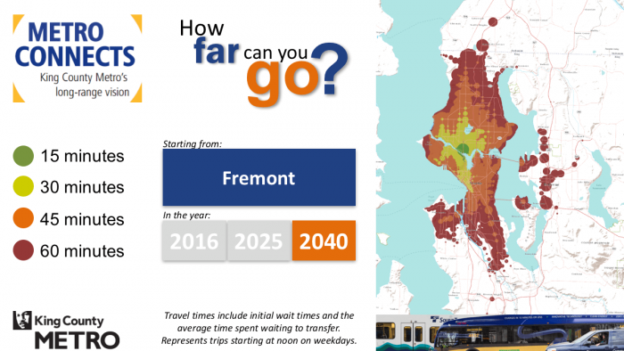
Nope.  Just pictures of the liberty and opportunity of human beings, like this:Slide039


This image means that in 2040, if you’re in the Fremont district of Seattle (the center of the dark green dot) you’ll be able to get to anywhere in the brown area in 60 minutes. The animation steps you through how small this area is now, and how it grows over time under the plan.  It does this for over 70 sample destinations around the region.

If you want to get around on transit and walking, think of this brown area as the wall around your life.  Make it bigger, and your life is bigger: more jobs you could hold, more schools you or your kids you could go to, more clubs you can belong to, more people you can meet, befriend, maybe even marry.

At my firm, we almost never do a plan anymore without drawing these, showing how they differ based on various alternatives under study.

Because we think people are tired of arguing about rail vs buses, and about transferring, walking distances, waiting times, dwell times, platform heights, and all the other arcana that make most transit conversations seem maddening and inaccessible.  Instead, we want to talk about something everyone cares about: liberty and opportunity.

Diagram by King County Metro Transit, part of their “Metro Connects” strategic plan.  Produced in Remix.  

Seattle: Your Rapid Transit System Now Has a Core!

Reposted from January 26, in honor today’s big event.

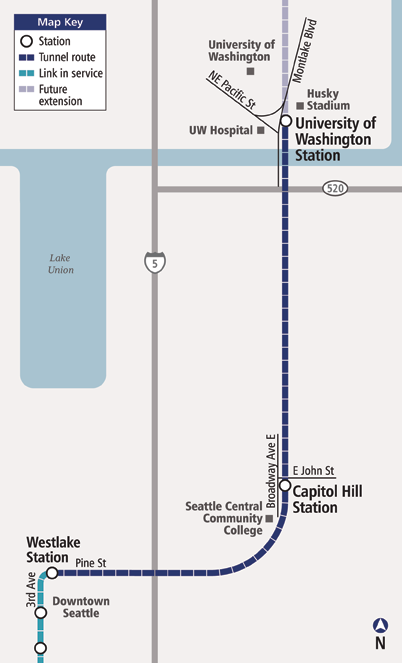
The Seattle region’s rapidly growing rail transit system crosses a major milestone today  The segment between downtown and the University of Washington, via a station in tMAP_Draft1_U-Linkhe dense Capitol Hill neighborhood, opens today.  And if you vaguely associate Seattle with vast delays and cost overruns on tunneling projects, give Sound Transit credit:  This one is 6 months early and $150m under budget.

However far the region’s rail transit network expands, this will probably always be its busiest segment.  It’s not just that the link between a robust downtown and a major university is the biggest transit market in many comparable cities.    It’s also that a good 40% of the region — northeast Seattle, all the northern suburbs and some eastern ones — will eventually end up on trains through this segment to get downtown.

This year will be another milestone for Sound Transit: the 20th anniversary of the passage of its first ballot measure, which funded the now-existing line between the airport and downtown.  Through its next successful measure, Sound Transit 2 (ST 2) in 2008, the agency is now funded for long extensions north to Lynnwood and east through Bellevue to Redmond.  Meanwhile, they are starting a lively public discussion about the next ballot measure, ST 3, which will probably include an additional rail transit line in Seattle as well as several possible suburban extensions.  City of Seattle voters last year also passed Move Seattle, a measure that among other things greatly expands bus service in the city.  All in all, a great year for one of America’s most ambitious transit cities.


Weekend Ramble: Empathizing with the Fear of Urbanism

Last Thursday, I joined a panel discussion put on by the Seattle Times about "gridlock".  Mike Lindblom of the times summed it up here, and I previewed it here, but I'm thinking about the guy who came up to me afterward.  

At great length, he told me that Seattle's streets had been planned and designed for cars.  He began listing specific streets, why they were built as they were, with the number of car lanes that their designers had intended.  

He objected to what was happening to his city's streets: replacing 4 tight lanes with 2-3 lanes to add room for bikes, pedestrians, and transit stops.  Not because he hates those things, but because we were betraying the original intent of the design.  These were meant to be car streets, so they should always be car streets.

The conversation sticks with me because he wasn't angry.  (Angry people are boring and unmemorable.)  Instead, he seemed more offended and hurt.  The urbanists remodeling Seattle's streets were betraying a promise that someone had made to him.

I don't agree, but I can feel his feeling.  This kind of empathy, I contend, is a stance worth practicing.

Here's an example, or maybe a confession.   I'm one of those tech users who've been trained by experience to fear so-called upgrades.  Just now, Apple told me to upgrade to "El Capitan," and all about how it would be better.   None of the featured improvements are things I want, so my first reaction is that they're just adding complexity and thus increasing the risk of malfunction and confusion.  Based on my experience, I'm entitled to suspect that (a) they've probably introduced new bugs and (b) they've probably wrecked something that I do value about the current version.  

So I'm kind of person who upgrades at the last possible moment, only when the oldest version is collapsing into engineered rubble.

Computers are one of many spheres where I'm happy with what I have and would prefer it quit changing.  What's more, what I have and like is what I feel the tech companies promised me, in other marketing messages long ago, a promise that I can now see them as  betraying.

Maybe you don't have this feeling about computers, but I bet you have it about something. 

Another word for this feeling of betrayal might be invasion.  Because really, we're talking about home, and the fear of the invasion of home.

In my early fifties, I'm at home with with my hard disk and thumb drives, just as my mother, in her seventies, is at home with notebooks and manila file folders.   When Millennials tell me my stuff should be in the Cloud, it doesn't matter what the argument is.  The feeling is that Stalin plans to knock down my sturdy and ancient hovel, move me to a shoebox in a concrete modernist tower, and put all my stuff in some mysterious storage promising me that the System will take care of it.  

So yes, I'm conservative in this most primal sense of the word:  I get defensive about various kinds of home: physical and intellectual.  And at this primal level, I bet you are too.  You may be sold on the Cloud — and maybe you're right — but I bet you have a ferociously defended sense of home about something.  If you feel aversion about something changing, or anger about something having changed, that's it.  

And this kind of conservatism could be more compatible with advocating necessary change, but only if we who advocate change could hear it, and convey that we hear it.

Now and then I'm reminded that for a lot of people, "home" includes their car.  If that's the case, then of course "traffic" is as offensive as Stalin threatening to knock down your hovel.  And then I see this on a street in Portland today:

IMG_6532

This is the universal fear-image of other people's cars: not your friends and family, and therefore something invading your neighborhood, your home.  (It's a night image because in the day you might recognize the driver, and be less fearful.)  And so the battle between homes, yours and that evil motorist's, is joined.

I think about these things on a rainy weekend to remind myself that conflict about changing the built environment is inevitable, because we are so deeply wired to fear for our homes.  What's more, our sense of home can be so extended into the world (as our cars, neighborhoods, or for environmentalists, our planet) that it will inevitably conflict with the "home" of others..  

But even if we can't agree with someone about an issue, we should practice empathizing with the feeling that something we rely on is under threat.  Because on some issue, I bet you have that feeling too.
Seattle: Before the Live Debate, the Written One (and an Imptertinent Question)

Login_logoSetting up for our panel discussion this Thursday night, the Seattle Times asked each of their panelists to answer some canned questions about the future of transportation.  The result is here.  I hope the contrasts will motivate you to come!  

Bravo to Bryan Mistele of INRIX (the traffic consultants to the notorious TTI Urban Mobility Report) for being willing to come into the densest part of Seattle and announce that (a) cars are our future and (b) light rail is a bad investment because of its ridership in the early years.  (Both claims presume the linearity of past trends and the irrelevance of land use changes in response to transit.)  But the courage is admirable: To say these things in the middle of Seattle would be like me pitching high-intensity transit networks at the Elks Hall of a small town in Nebraska.

Which raises a key point:

Notice, as you read this, how all high-level discussions, at regional levels or above, tend to presume that there is some answer to the "transit vs cars" question that is the same everywhere.  

In fact, the answer is radically different in different places, based on known built-environment factors and local politics that tend to track closely with those factors.  Some places are suited to cars and therefore defensive about cars.  Some places function only with transit, so they view transit as an existential issue.  All urban regions — and most states, provinces or countries — are going to have both kinds of places and everything in between.

So my question going in is this:  Why can't we let Seattle have the kind of transportation system it needs, and let low density and rural areas have the kind that they need?  Why do the differing needs of different communities require that we have a war between those communities, at all levels of government?

Knowing it in your hands

IMG_4520I'm writing this while our Interactive Course in Transit Network Design in Seattle goes on around me.  About 25 people are huddled around maps having intensely animated conversations about what the best possible transit network would look like.  Now and then someone comes up and asks a (good) question.  

This kind of workshop is not just "inexcusably fun," as one student called it, but it's also the best way to get a practical grasp of the transit tool.  If you've actually tried designing a transit network, you have some knowledge of the material in your hands, not just in your head, and hand-knowledge is easier for the mind to trust and integrate.  Hand-knowledge (also called body knowledge) is knowledge you trust without even having to think about it.  It's the very essence of what we perceive as obvious.

The biggest problem facing urban transportation in North America is that most influential people have hand-knowledge of driving cars but only brain knowledge of other transportation options, if that.  Hand-knowledge is so powerful in us that it governs the metaphors and assumptions we bring to other topics.  When people ask me why transit isn't serving their labyrinthine business park, or ask why it can't run smaller buses that fit better into their neighborhood, or why it can't run sexier vehicles with nicer seating, they're assuming that transit is just like cars, only bigger.  And until you've taken some time to play with what transit really is, that's a compelling delusion and therefore a consequential one for policymaking.  

Transit is not just like cars.  It's also not just like bikes or any other private vehicle.  It's not just like taxis or Uber either.  It's a completely different thing, and to know it you have to touch it.

A lot of experienced transit riders do have this kind of knowledge, though you also have to be able to separate what's convenient for you from what makes a good network for the city.  (The public outreach for the Houston System Reimagining asked people both "Is this better for you?" and "Is this better for Houston?" to try to prompt both kinds of thinking.).  Many existing transit riders aren't able to make that distinction, but those who can become powerful advocates and leaders.  

Hands-on workshops are also the essence of my firm's approach to all forms of outreach, not just formally educational activities like this course.  A key part of all of our planning projects is the stakeholder workshop, where key leaders from a city sit down and do network planning exercises together.  At first it seems amazing that such busy people are willing to take the time to do this, but on reflection it's less so.  Great leaders know they don't know everything, and are eager for fun ways to expand their hand-knowledge.  

The other great frontier, of course, lies in web-based tools that let people have some of this experience at home.  Explicit games that involve designing transit networks are either wildly simplifed (Mini Metro) or arcane (Cities in Motion) or massively misleading (Sim City).  (I've heard good things about Cities:Skylines but don't have the supercomputer needed to run it smoothly.)  What's needed is something less graphically complex that still helps people explore the essences.  

But of course games don't have to call themselves games.  Transitmix is an excellent and fast-developing tool for sketching and costing transit networks.  As it adds features that measure outcomes, it takes on the features of a game:  It's a space where you can try out different transit plans, see the results, and gradually figure out what kinds of network work best.  This is one of the most effective kinds of learning, because the result is hand-knowledge.  

Hand-knowledge doesn't always make you an explainer, of course.  I've met many transit planning professionals who have great instincts but can't describe their thought process. So we work back and forth between hand-knowledge and brain-knowledge.  Feel how this substance works in your hands, but then spend a little time thinking more about what you've learned from that. Get your brain and your hand on the same page.  Then you're ready to change the world, or at least figure out the real transit issues in your community.  

in the pacific northwest, the romantic drama is on the bus …

This really is too much fun.  From a scholarly study of the Craiglist "Missed Connections" section, where people express a romantic interest in someone that they saw out in the world.  You know, ads like this:

We were both on the max [light rail]–me heading to the Blazer's game and you on your bike. You overheard part of my conversation with my friend and were quite amused. I wanted to talk to you but then got pushed back by other riders. Email me if you remember that conversation and would like to grab a drink sometime.

So here, by state, is the location most often cited in "Missed Connections" ads (click to sharpen):

ZI-1175-2013-J-F00-IDSI-76-1
In rail-rich older urban areas, it's rail transit, of course, the subway or train or metro.  But in relatively rail-poor parts of the country, only Oregon and Washington find so much wistful romantic drama on public transit!  This is one of those slightly twisted points of "Portlandia"-style pride that makes me proud to be an Oregonian transit planner.  

the opportunities and dangers of incomplete bus rapid transit

One of Bus Rapid Transit's great virtues is that unlike rail, you don't have to build a complete, continuous piece of infrastructure if you really only need segments of one.  

Here in Portland, for example, the Barbur corridor — now being studied for BRT or rail — features a series of congested chokepoints with generally free-running traffic in between them.  Here, a BRT facility that got transit through the chokepoints reliably probably wouldn't need an exclusive lane in the free-flowing segments, because traffic in those segments would continue to be metered by the chokepoints and thus remain uncongested.  (Congested chokepoints meter traffic just as ramp meters do: they limit the rate at which cars can enter a road segment and thus reduce its chance of becoming congested.)

Unfortunately, Bus Rapid Transit can also be implemented in exactly the opposite way.  Severely congested chokepoints are generally expensive places to design transit priority for, especially if you're unwilling to simply take a lane for transit.  So we often see BRT projects that are missing where they are most needed.  The Boston Silver Line 4-5, like the Los Angeles Silver Line, can get stuck in traffic downtown.  New York's supposed BRT is so compromised that many refused to call it BRT anymore.  Even the world-class Auckland North Shore Busway disappears as it approaches the Harbour Bridge. 

Now we have the example of Seattle's RapidRide D, highlighted today by Mike Lindblom in the Seattle Times:

While the new RapidRide bus mostly lives up to its name in West Seattle, passengers on its sister route to Ballard are routinely stuck in traffic.

The service to Ballard, called the D Line, is d

2019776700

elayed 10 to 15 minutes by late-afternoon car congestion leaving Belltown and winding through the crowded Uptown neighborhood, near Seattle Center.

That bottleneck is aggravated by traffic signals that haven't yet been re-timed by King County Metro Transit and the city of Seattle, to give the buses a longer or quicker green light. Metro acknowledges the D Line is just one minute faster than the local bus it replaced Sept. 29; the advantage is supposed to be six to eight minutes.

Transit managers hope to make gains by early 2013 after signal and road-lane changes are finished.

"We have a ways to go based on our early experience, but it is still too early to know whether the projection will be achieved," said Metro spokesman Jeff Switzer.

M674_0Just one minute faster than the bus it replaced?  Then the question arises: Why was it called Rapid Ride prior to the improvements that would make it Rapid?  There are some plausible if grim answers to this question.  Getting multiple big bureaucracies to move on the same timetable to the same deadline is hard.  The transit agency has to commit to a date months in advance, without being entirely sure whether its partners (typically in the City and the state Dept of Transportation) will be done with the improvements that are their responsibility.  So sometimes, the brand appears before the product does, causing this understandable blowback and also, more critically, tarnishing the brand.

RapidRide D raises a larger problem though.  Even when planned priority is completed further south there is still the problem of the congested Ballard Bridge.  Like Barbur's chokepoints in Portland, the Ballard Bridge is a familiar chokepoint that affects speed and reliability for all transit services forced to use it.  You can imagine the difficulty of demanding that RapidRide have an exclusive lane over the bridge, when that would leave only one for other cars.  (But what about a lane for buses + carpools + carshare cars + electric cars + etc. until you get a reasonable but uncongested lane volume?)

Sometimes, too, bridges can be metered, much the way the San Francisco Bay Bridge toll plaza meters traffic on that bridge.  At the approach point pictured above, a signal could have been placed at the bus merge point which meters traffic so that northbound congestion piles up south of the bridge rather than on it, and enters the bridge only at an uncongested rate.  That would have allowed buses uncongested operation without really slowing down cars much.  I'm not an engineer; there may be valid reasons why this wasn't possible, but it's the sort of solution that comes up when congested traffic is the reality anyway and the goal is to protect transit from it.

Transit agencies sometimes compromise BRT for their own reasons of budget.  Issues of boarding time associated with the lack of on-street ticket machines are coming up on RapidRide, as are concerns about reliability arising from the fact that two RapidRide lines are through-routed, transmitting delay from one to the other.  These are familiar struggles within transit agencies who are under pressure to spread a product over many corridors and can't afford to deliver every aspect of the product in all those places.  The result runs the risk of becoming symbolic transit; a bright red line appears on the map, but without the investment needed to make good on the promise that the red line implies.

I've received emails from Seattle friends on several sides of this issue, and sympathize with all of them.  I don't mean to criticize either the City or the State DOT or the transit agency, because what was done here is fairly typical historic American practice and the pressures involved are so routine.

But if there is a desire to aim higher than historic American practice, the question remains.  How much can we compromise BRT — tolerating its absence precisely in the congested chokepoint where it's most needed — and still call it BRT?  Might be better for transit agencies to refuse to implement BRT until the relevant traffic authorities have delivered the facilities it requires?  

seattle reveals its frequent network

Bravo to Seattle's King County Metro for their new system maps, which finally reveal their Frequent Network.  All can be viewed and downloaded here.  

Seattle NW slice

The wide blue line is light rail and the red lines are the new Rapid Bus product (both frequent and relatively fast).  The rest of the bus network is clearly presented in ways that advertise its frequency and span, so that (a) the Frequent Network jumps out at you and (b) services that run only at rush hour recede from attention so that you can clearly see the network that runs all day.  They do this by using black (numbers and lines ) for the Frequent Network, then solid blue for the other all-day service, then paler blue with blue-outlined white number bullets for the peak-only services.

Works for me.  What do you think?  If your transit agency hasn't figured out Frequent Network mapping yet, show them this map, and tell them to read Chapter 7 of my book, or this!

greater seattle: loving the new sub-network maps

Now this is a clear map!  It's by the Seattle area agency King County Metro.  First the legend:

KC metro legend.png
RapidRIde is King County Metro's new rapid bus product, with widely spaced stops, high frequency, special stations, but usually no exclusive lane.  Note how cleanly this legend distinguishes services that are useful for different purposes.  Note too that it omits peak-only commuter express services, because if they were present they would be lots of confusing overlapping lines that would make the basic network impossible to see.

So here's a piece the map.  Click to enlarge, but more important, go here (that's an order) to see the whole thing.

KC metro eastside map

The distinctions on this map are entirely about what matters to the customer, especially the person who wants to see the all-day transit network that is ready to liberate your life, not just your commute.  Red means fast and frequent.  Blue means frequent.  Green means all day but not frequent.  And if you want to see peak commuter express services, which would obliterate the legibility of this map if they were included, see another map or individual timetable.  

To be fair, many good maps do show peak only services and visually de-emphasise them as faint dashed lines.  That works too, but the key design principle is this:  The network of any particular layer in the hierarchy of service should be clear without being obscured by lower levels of service.  This map does that perfectly:  You can see just the red Rapid Ride line, or you can focus easily on red plus blue to see the frequent network, or you can notice the paler green and see the all-day network.  All in one map.

To get to this kind of customer-centered clarity, note what they had to omit:  Two transit agencies' services are presented here with no differentiation at all.  Bus routes numbered in the 500s belong to Sound Transit while the others belong to King County Metro.  Most multi-agency regions would focus on highlighting this distinction first, on the assumption that the customer's loyalty to a transit company is much more important than their desire to get where they're going.  The distinction should arguably be at least a footnote if you don't have integrated fares between the companies, as it could imply fare penalties and different fare media.

Some multi-agency maps do show all operators, but still visually distinguish them, as the Los Angeles Metro map does, for example.  But if you want a really simple map, reduce the transit company's identity to a footnote, or something that can be inferred from a route number*, or don't even show it at all.  Instead, show the customer what matters to them: frequency, speed, and duration of service.

*Can you spot the one place on the LAMetro map where they do that?  The answer is in "Joseph E"'s comment below.