Cuts

how to (not) sound elitist when discussing transit


PTOD240x300.ashx

This is not a balanced book review. While I will start with some general praise of this new book, I must focus on a few passages about public transit that are both misleading and potentially harmful.  I do this not to challenge these authors in particular, but because these mistakes are so common in urbanist writing and need to be called out wherever they appear.

Reid Ewing and Keith Bartholomew, both at the University of Utah, have a new large-format paperback offering a concise overview of the basics on Pedestrian and Transit-Oriented design.  If you want a good glossary of key urbanist concepts such as imageability and coherence, or you want a good and well-cited argument for local street connectivity, this is your book.  

Very usefully, the book is organized as a series of checklists:  Here are the features that you must have to be considered transit-oriented design, here are others that are desirable.  It's designed to be handy to the time-crunched developer or policy person.  In fact, it meets one of the most important standards for an influential book in our distracted age:  You can get most of the message by just looking at the pictures and reading the section headings.  

The writing is good, too, clear and with careful attention to explaining and demystefying concepts.  With one exception, I could recommend this as a good reference guide to the key concepts of pedestrian-oriented design.  

As a guide to transit-oriented design, however, it has a fatal flaw:  The authors make recommendations about transit that make sense from a design and development point of view but are nonsense to many experienced transit planners.  These recommendations will sound elitist and tone-deaf if you present them to your transit agency.  As always, I emphasize sound; I've talked with enough urbanist writers to know how good their intentions are; they are mostly genuinely surprised when their comments about transit backfire.  But it's not a hard mistake to avoid.  I am going to take apart a critical passage in the book not because it's typical — it's an unusual flaw in a good book — but because it illustrates a lingering problem with urbanist discussions of transit in general, one that I hope we are close to moving beyond.

Ewing and Bartholomew lead off their transit discussion with this tired old chestnut:

In the quest for efficiency, transit has become dull and utilitarian, part of the problem reather than the solution to today's lifeless streetscapes (Coppe 1991).  [p 82]

If this generalization is really about "today," then how is it bolstered by a 22-year old citation?  Obviously it's true to a degree, more in some cities than others,  but there has been transformative progress in the last two decades.  Fleet, facilities, and technology have been upgraded across the developed world, often with the input of great designers.  Do transit agencies get no credit for the evolution in the comfort, openness and access that have happened over the last generation?  

More fundamentally, this line conveys disinterest of the  nature of transit's success, a disinterest that is tragically common in urbanist professions.  The word efficiency is used as though all readers would agree it's a misguided goal.  But when working under any fixed budget as transit agencies do, efficiency is the same thing as abundance.  (When something called efficiency is genuinely destructive or unsustainable, it should be called false efficiency.  Freeways, fracking, and industrial farming may be less efficient than they look because of externalized negative impacts.  Questioning those things doesn't amount to questioning efficiency.)

As for the word utilitarian, it has a technical meaning in philosophy but here it's a dismissive word meaning useful.  Anything that scales to a vast network that's potentially useful to thousands or millions of people can be called utilitarian.  Great transit agencies wear this term as a badge of honor.  What's more they prove that usefulness is beautiful.

But the authors dig themselves deeper.  After showing us pictures of charming, distinctive bus shelters in two wealthy communities that can afford them, they write:

In some cases, transit operators might do better by putting fewer buses on the street at times of low demand, and diverting the money they save into bus stop amenities and fleet facelifts.

This, urbanist friends, crosses a bright red line called upward redistribution of wealth.  

This book appears at a time when many US transit agencies have been slashing transit service for the last five years, driving away legions of riders.  Portland, for example, has had its inner city grid network gutted — mostly cut to 20 minute frequencies at which the connections on which it relies are almost impossible — even though frequent transit service is a foundational element in the City of Portland's neighborhood development policies. 

Any "low-ridership" services that have survived all that carnage are serving popular and important non-ridership goals.  They are not going to be cut to build nicer bus shelters.  Doing so could also be illegal in the US if you're using Federal funds: US Title VI legislation (part of the 1964 Civil Rights Act) is designed to prevent exactly this kind of upward redistribution of the benefits resulting from public investment.  All US transit agencies that receive Federal funds must do extensive analysis to prove they are treating low-income and minority riders fairly in both service and infrastructure.

So if you follow this book's advice, and tell your transit agency they should cut service and force lower income riders to buy cars so you can pay for  nicer bus shelters, it doesn't matter how noble your intentions are.  You will sound elitist.  You will sound especially hostile to the burgeoning environmental justice agenda that is already embodied in civil rights legislation, and that has its own strong nexus with the ultimate outcomes that we call sustainability.  If you prevail in guiding the policy of your transit agency, that agency could be exposed to civil rights lawsuits as a result.  Do you really want this many enemies?

It doesn't help that in suggesting service cuts at "times [rather than places] of low demand," the authors are just repeating a common misconception.  Ridership at different times of day is interdependent, if only for the obvious reason that most transit trips are round trips.  If you cut service and thus reject a customer at one time of day, you'll likely lose their business in the other direction as well.  The most obvious "time of low demand," the late evening, is also a "guaranteed ride home," which means it affects the overall attractiveness of the product.  Finally, lower-income riders who form the bedrock on which transit grows are especially likely to be travelling in the evening; cut their service, force them to spend their scarce money on cars, and you've shoved them further into poverty.

A consistent pattern of all-day service (including "times of low demand") is a powerful tool for fostering lower vehicle ownership.  That's is why many transit agencies are now committing to a policy "Frequent Network" that guarantees service over a certain span regardless of trip-by-trip ridership.  (These policies, important in guiding true Transit-oriented Development at regionwide scale, deserved a mention.  Policies in the Portland and Vancouver BC regions could both have been cited.  Indeed, the book is silent on the urgent question of how to recognize a suitable site for TOD.)

I love distinctive transit shelters as much as anyone, but not if they are defined as an alternative to the sheer quantities of service that cities need and that ridership would reward.  (Canadian midsized cities, for example, generally have about twice the ridership per capita of similar US cities, not becuase their shelters are cuter but becuase they run about twice as much service per capita.)

Distinctive, adorable shelters can still come about in one of three entirely reasonable ways.  Either:

  1. they have been paid for by developers, or by neighboring landowners who will profit most directly from any uplift in land values, or
  2. they have been paid for by city governments as a form of beautifcation, or
  3. they are transit agency investments that are affordable and suitable for mass production, like the San Francisco shelters with the characteristic wave roofs.  

Developer-funding (also endorsed in the book) is often the purest nexus of all, but city funding is also a healthy trend.  City governments are much better placed than regional transit agencies to make investments that express civic identity and character.  Most US cities can also do improvement districts that focus the cost on the landowners who will most benefit.  Still, it's usually wealthier communities that can afford to do this, so it's deeply misleading to present these specialized shelters as realistic examples for cities in general, let alone to suggest that cash-strapped agencies should reject existing riders in order to pay for them.

It's hard to even criticize Ewing and Bartholomew for these howlers.  As long as I've been in the business, I've heard leading urbanists lecturing transit planners about how they should abandon their obsession with abundant service and focus on aesthetics instead.  As someone with serious credentials in the arts, my response is always that I understand the aesthetic values that the urbanist is describing, but that their recommendation is pointless until they own the consequences of the cuts they are implicitly proposing to fund these things. 

To be fair, transit agencies have been slow to engage urbanists in their own language, which requires staff with appropriate expertise.  This, however, has improved dramatically over the last decade.  Most leading transit agencies in major US cities have design and land use professionals on staff.  Working urban designers and architects are responding constructively to transit agency input, and respectful conversations between the fields are happening more than ever.  Most urban design and architecture professonals that I deal with are sensitive to real-world transit issues and open to learning about transit agency perspectives, so we can hope for a continued spread of insight on these issues.  

Indeed, Ewing's and Bartholomew's book shows how far the urbanist discourse has come in respecting transit and the diversity of its riders.  They speak mostly of "transit," avoiding rail vs. bus arguments, and their photos show buses as accepted parts of the urban landscape deserving of attention.   This is real progress, still controversial in some quarters.  It was partly in the context of this larger sensitivity that the passages quoted above were so shocking.

In the long run, urbanist thinkers who discuss transit must learn to respect transit network design and policy as a genuine expertise — something that's worth learning about before you comment on it.  Again, my own experience suggests that the practice is ahead of the literature in this regard.  This book — very useful on all subjects except transit policy — shows how far urbanists' respect for transit agencies has come since the early days of the New Urbanism, and how much — or perhaps how little — remains to be done.

portland: the grid is 30 years old … thank a planner!

Thirty years ago next week, on Labor Day Weekend 1982, the role of public transit in Portland was utterly transformed in ways that everyone today takes for granted.  It was an epic struggle, one worth remembering and honoring.

I’m not talking about the MAX light rail (LRT) system, whose first line opened in 1986. I’m talking about the grid of frequent bus lines, without which MAX would have been inaccessible, and without which you would still be going into downtown Portland to travel between two points on the eastside.  (Full map here.)

Portland grid\

What did it look like before 1982?  Here’s a bit of the 1970 network (full map here).

Portland 1970

The 1970 network consisted of bus routes radiating from downtown across the gridded eastside, which constitutes about 3/4 of Portland.  If you were anywhere on this network, you had a direct bus downtown — a slow, circuitous, and infrequent bus.  Very few routes ran better than every 30 minutes during the day.  Only two routes ran north-south across the east side, and both were too infrequent to transfer to, so you couldn’t really use them unless both ends of your trip were on them.

How did the 1982 network transform the possibilities of mobility in the city?

  • The old network was solely about going downtown.  The new network was about going anywhere you wanted to go.
  • The old network was infrequent.  The new network required easy connections, so it was designed to run at high frequency (most lines every 15 minutes or better all day).  Remember: Frequency is freedom!
  • The old network was wasteful, as many overlapping lines converged on downtown.  The new network was efficient, with little overlap between lines, and with lines spaced further apart to the extent that the street network allowed.  This is how the resources were found to increase frequency so much.
  • The old network was complicated, with routes often zigzagging from one street to another.  The new network was simpler, easy to keep in your head.  Many streets that were formerly served by a patchwork of overlapping routes, such as Division, now had a single route from end to end, so that you needed only remember “the Division bus.”  Transit became an intrinsic part of the street.

If you’re in a hurry, skip to “Thank a Planner!” below.  But if you have a couple of minutes, let’s explore more deeply how the grid transformed Portland, and why it was so controversial at the time.

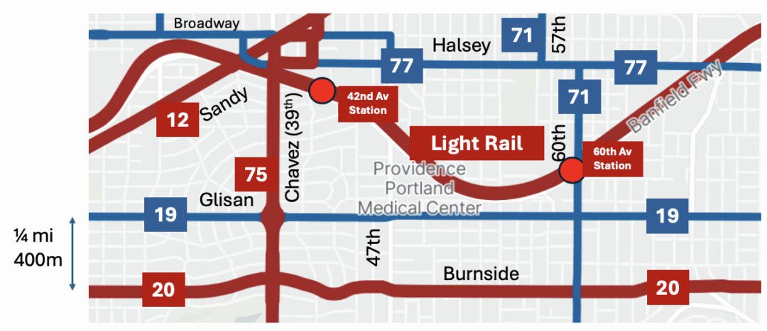
In both maps above, that wavy line across the middle of eastside Portland is the Banfield Freeway, where the first and backbone line of the MAX light rail system runs today.  In the 1970 image, look for the line marked “1” extending north from the Banfield in the middle of the image.  This is NE 42nd Avenue (a bit of which is labeled 41st, but don’t let that distract you).

In the old network the bus line along 42nd came from the north edge of the city, once an hour.  Partway down it merged with another branch, to form 30-minute frequency.  When it approached the Banfield, it turned west and zigzagged into the city via the Lloyd district.  Once it turned west off of 42nd, it was duplicating other routes the whole way.  If you wanted to go somewhere else on the eastside, the bus was not much use.   Frequencies were poor so it was very hard to make a trip involving multiple routes.

If you lived on NE 42nd in 1982, you were confronted with massive change, the sort of change that makes people scream.  Never again would you have a direct bus to downtown Portland.  Now you would be on the new 75, which would run continuously north-south all the way across the city.  And if you wanted to go downtown, you would have to transfer (as we called it in those days).

But on the bright side, the 75 would run every 15 minutes, so transfering wasn’t hard.  And in return, you got all the other benefits of a frequent routes that would let you connect quickly to reach destinations all over the east and north sides of the city, without going downtown.

This is always a tough sell, because many people value transit only for the commute downtown.  These people tend to complain when the network is optmized to serve many kinds of trip at once, which is exactly what the grid does.  A frequent grid is the ultimate in versatilityequity and freedom.  It does not pick favored destinations for favored markets. Instead, it delivers anywhere-to-anywhere mobility for wherever you might want to go.  Today, the non-downtown elements of the grid, especially 72 and 75, are among TriMet’s most productive lines.

The grid redefined the role of transit in serving Portland’s livability objectives.  When you think of everything that makes Portland both livable and culturally distinctive, you’re probably thinking about the historically dense and gridded part of the city.  This is where almost every cool urbanist outcome of the last 30 years — from food carts to bike lanes to office-over-retail — has sprouted and thrived most successfully. Rail gets all the press, but the MAX light rail line would not have worked without this grid to connect with it.  (The reverse is not true: the grid worked well for four years before the MAX line opened, though MAX was certainly an improvement that achieved further ridership payoffs.) As Gregory Thompson and Jeffrey Brown put it in a recent paper :

If the 1983 and 1986 restructurings had not happened, LRT would have been a competitor with the CBD-focused, poor quality parallel bus routes that already were there, and there would have been no high quality bus routes intersecting the LRT at right angles. Portland would have enjoyed much less patronage than it has since experienced on both its LRT and bus routes.

Where did all the money for the new high-frequency crosstown lines come from?  Removing duplication. Look again at the your ride on 1970’s route 1.  Once it turned west off of 42nd, it duplicated other routes the entire way into downtown.  Now look closely at the routes approaching downtown from further south in the old map.  They ran on so many closely-spaced parallel streets that they were effectively duplicating one another as well, wasting service.  The grid plan found many resources by removing these duplications and moving to wider and more consistent spacing of lines across the whole city.  In the same process,the grid introduced the idea that it’s OK to walk further to a more frequent and useful service — the foundation for transit’s link with walking (and with all of walking’s public health outcomes) today.

The grid was also a radical simplification, making it easier for people to keep the network map in their heads.  Now, bus lines would often follow the same street from end-to-end, so you could remember easily that there’s a Division Street bus, say, and an 82nd Avenue bus.  In the old network, if you wanted to go from 20th & Division to 82nd & Division, you had to go downtown and back, because these two parts of Division were covered by different routes.  The beauty of the grid is that your transit directions are sometimes as simply as walking or driving directions:  “Take the Division bus out to 82nd, then take the 82nd bus south.”  The transit lines are just part of the street.

Imagine, in 1982, the struggle involved in implementing this.  Vast numbers of people lost their direct bus to downtown, at a time when going downtown seemed like the only purpose of transit to many existing riders.  Transit agencies tend to listen most to their existing riders, who have adapted their lives to the system as it is, so it takes real courage for them to seek new markets instead of just catering to the existing ones.   Imagine the disruption, the rage, the recriminations, not to mention the apathy from people for whom buses just don’t matter, no matter what they’re achieving.

Thank a planner!

If you can imagine how hard this was, consider thanking the planners who took all this abuse and persisted in pushing the plan through, because they believed in everywhere-to-everywhere networks and knew this would work if it were tried.  I’m especially thinking of:

  • Ken Zatarain, who was a TriMet service planner at the time and who is still at the agency.  Thank him at:  ken dot zatarain at wsp.org.
  • Thomas G. Matoff, the single most important mentor in my own transit career, and probably the critical player in pushing the grid through.  Tom, who was service planning manager and thus Ken’s boss, was an eloquent, passionate and persistent advocate for the grid both inside and outside the agency.  He was the first person I’ve met, and one of the few I’ve known, who could convey how essential network design is to the life, joy, and prosperity of a city.  Tom went on to be General Manager of Sacramento Regional Transit and is now working on the Sonoma-Marin rail project in California.  Thank him at:  tmatoff at ltk dot org .

I’m dead serious:  If you value being able to get around Portland in all directions, thank them.  In other words, do one of these things:

  • shoot emails of appreciation to the three emails above, copied to me (jarrett AT jarrettwalker DOT net), with “Thanks for the grid” in the subject line, or
  • leave a comment here, or
  • say something on Twitter with the hashtag #PDXGrid .

You might also ask the two mayoral candidates about how important the frequent grid is to their vision of the city, and whether they think it should be enhanced.

Why does this matter?  Because even today, there’s disagreement in Portland about important the frequent grid is, or even whether a complete everywhere-to-everywhere network (which requires high-frequency buses as well as rail) should be a priority at all.  Some view the grid as unimportant, for example, because they view bus service as unimportant.

Purists might argue that the grid never made it to its 30th birthday, but rather perished at 27 in 2009.  That was the year that TriMet cut all-day frequencies below the 15-minute threshhold that is widely accepted as the definition of “frequent enough that you can use it spontaneously, without building your life around the timetable.”  Since the grid relies on easy connections to achieve its goal of easy anywhere-to-anywhere access, the 2009 cuts began to undermine the whole idea of the grid. TriMet avoided doing this in its first round of cutting after the crash, but felt it had no alternative in the second 2009 round.

Will the grid ever be restored to its necessary frequency?  Will it ever be expanded and enriched (as regional land use planning generally assumes it must be) with even better frequencies?  Not everyone in Portland thinks this is a priority, so you might want to express your view.

More on the history and spectacular outcomes of the grid if you click below.  But even if you don’t click, thank a planner!

Continue Reading →

portland: balance the budget yourself

Portland's Tri-Met faces another horrible funding shortfall this year, but they've come up with a good survey tool to engage the public in their decisions about what services to cut.  It's one of those "balance the budget yourself" tools that's becoming increasingly necessary to bring voters into contact with reality about government budgets.  

If you live in Portland, you should definitely work through the survey and send them your own balanced budget and comments.  If you're not in Portland, is your transit agency communicating about its trade-offs this well?

los angeles: deleting some lines can be fair

The New York Times today bewails the loss of Los Angeles bus line 305, which soon will stop running diagonally across the city's grid, from Watts to Beverly Hills and Westwood. 

4bus-map-popup

NYT reporter Jennifer Medina assumes this is purely a victimization-of-the-poor story, starting with this observation:

The 305 was one of several lines created under the consent decree, and it is the only direct route from the city’s impoverished southern neighborhoods to its affluent West Side, where legions of janitors, nannies and maids work each day.

Sounds sad, and it's easy to fill an article with interviews with 305 riders who will experience the deletion as a hardship.  But as that paragraph should warn us, 305 was a symbolic service.  It cannot have been relevant to very many people, not even to many people in the targeted demographic ("janitors, nannies, maids" according to the NYT).  Why?  If you explore the route and schedule [ Download PDF ] and look at how the route fits into the larger network ("System map overview" here), you'll notice:

  • Line 305 is a diagonal shortcut across a high-frequency grid, where trips between anywhere and anywhere can usually be made on lines running every 15 minutes or better with some are far more frequent than that.  Meanwhile, the Line 305 frequency is every 40-60 minutes.  [PDF]  That means that the 305 is the fastest path between two points on the line only if it happens to be coming soon.  If you just miss one, there's another way to get there faster, via the much more frequent lines that flow north-south and east-west across this entire area. 
     
  • The 305's low frequency exposes its riders to the risks of waiting for a single bus: you're basically making an appointment with one driver who may not show up for a variety of reasons.  Routing the same trips via the high-frequency grid means much higher reliability, because the abundance of buses along a line means you are less dependent on any one of them.
     
  • Most important, the alleged target demographic — trips from the "poor south" to the "affluent west" for domestic workers — was mostly not served by the 305.  Both the "poor south" and the "affluent west" are enormous areas.  So no one bus line was ever going to connect all or even most of the "poor south" with all or even most of the "affluent west." 

These points, but especially the last, identify a public transit service as symbolic.  Symbolically, the 305 links the "poor south" and the "affluent west," and thus helps everyone feel good about having served domestic workers.  In fact, the 305 runs through a small part of the vast "poor south" and a small part of the vast "affluent west," but it's still useless for most of the people making that kind of trip, because both areas are so large that no one bus line, or even five, could link all of the likely origin-destination pairs between them.

(You could take other buses in each area and transfer to the 305, but the low frequency of the 305 makes this very risky.  Once you've accepted the need to connect, you might as well ride along the main grid and connect with a high-frequency line to take you where you're going.)

This problem is why frequency and connections were invented.  The governing principle of transit in these core parts of Los Angeles is the high-frequency grid, which allows everywhere-to-everywhere travel at high frequencies with at most one connection.  Yes, it may be sad that some domestic workers who are used to zero-transfer trips are now going to have a one-transfer trip, but that only means that 305 riders will have the same level of transit mobility that everyone else has, including most domestic workers.  It also means that Los Angeles transit will be treating all of this demographic equally, rather than arbitrarily preferring people whose path happens to lie along Line 305.

The other moral of this story is even simpler: If your mission is to serve a whole city or region, designing transit routes around any self-identified group of people is almost always a bad idea.  Most successful and attractive transit seeks maximum versatility, by serving the most diverse possible range of demographics, trip purposes, and origin-destination pairs.  You can make exceptions where a single demographic group produces sufficiently massive ridership, as in some commute markets.  But in general, the way people self-organize and self-identify politically is a bad guide to how to meet their transit needs efficiently.  Everyone can draw the perfect transit line just for their interest group, but such proposals tell you nothing about what a good transit system would look like.

Nobody should be happy about the severe cuts being imposed on many US transit agencies that urgently need to move in the opposite direction.  But as in San Francisco in 2009, cuts are sometimes an opportunity to delete services that have passionate, well-connected defenders, but that simply don't make sense if your goal is a complete network that people can use to go wherever they're going.

San Francisco: May 2010 Service Cuts Mostly Restored

As I said at the time, the first round of service cuts in San Francisco implemented in 2009 actually did some good by deleting some segments that, for geometric reasons, were always going to be ineffective.  But the second round implemented in May 2010 were mostly just painful.  Now, after a long struggle, that destructive second round is being reversed, mostly on September 4 with the remainder to come in December.  I often criticize journalists for featuring bad news but missing the corresponding good news, so it’s only fair to do the same myself.

Willingness to Pay for Transit Improvements

Los angeles frequency survey Do your city’s political leaders understand what funding sources people would support if they knew what they were buying?  A few weeks ago, the Source (a blog by the Los Angeles transit agency Metro) reported on a survey showing that current riders would pay 50c more in fares for a doubling of their frequency of service.  This isn’t as encouraging as it sounds, because a doubling of frequency, even with significant ridership increases as a result, will cost a lot more than 50 cents per new rider.  But it’s a useful soundbite.  These questions, broadly called “willingness to pay” questions, need to be asked more, and more probingly. Continue Reading →

Seattle Suburbs: The Silence of Sundays

Community Transit, which serves most of the northern suburbs of Seattle, is shutting down completely on Sundays.  This wouldn’t be unusual in a small-city transit system, but CT’s service area (most of Snohomish County) is a big suburban expanse with about half a million people.  It has enough transit demand to support a low-end Bus Rapid Transit line, called Swift, which will presumably not run on Sundays either.

This is a fairly dramatic step by North American standards.  Local transit in suburban areas generally appeals to people with few choices, but many, many of these people work in low-wage jobs in the service sector, such as restaurants and big-box retail.  These business are open seven days a week and often are busiest on weekends, so most of their employees have to work some weekend shifts.  A transit system that doesn’t run on Sundays will no longer be useful to these people.  Based on what I’ve seen elsewhere, most of them will find other arrangements; CT is likely to lose them on all five days a week that they travel, not just Sunday.  Some, those without any good transport options, may lose their jobs.

I hope CT or some other local government researches what happens to these riders when Sunday service ends.  The best approach might be to survey the Sunday riders before the service stops, asking them for follow-up contacts so that they can be interviewed again a few months in the future.  This would not only provide good data for other agencies facing the need to cut service, but would also be a nice way for the agency to convey some concern for the well-being of these customers.

New York: Free Student Fares and the Budget Crisis

Today’s New York Times editorial on New York’s transit funding crisis goes beyond general warnings about the need to fund transit and digs into specifics: Raise bridge tolls, resist election year tax-cutting, hold the line on pay raises, and this:

What it should not mean is doing away with free passes for needy students. Both the state and city will have to contribute more to help pay $214 million a year to help keep these students in school.

Perhaps they read this.

Unemployment and the Transit Imperative

As US leaders suddenly pivot to focus on unemployment, Emily Garr at The Avenue picked up on a line of President Obama’s recent speech in Lorain County, Ohio.

You can’t get to work or go buy groceries like you used to because of cuts in the county transit system.

She goes on to describe cuts in the transit services to this suburban county that are definitely not “trimming the fat” but more like multiple amputations.

Transit advocates need to be picking up this line.  Back in the mid-90s, when welfare reform was timely, I routinely ran passenger surveys on various transit systems as part of planning projects.  The surveys had many other purposes, but I made a point to ask both “what is your trip purpose?” and “if transit had not been available, how would you have made your trip?”  A common answer to the second question was that the person would not have been able to make the trip.  Cross-tabulate that with a trip purposes of “work” and you get a count of people who could not hold their jobs without public transit.  It’s an easy thing to do in any customer survey, and every transit agency and advocate should know this number.

It’s also important to notice that the people who are on the verge of not being able to hold their jobs are mostly in relatively low-wage jobs in the service sector — restaurants, fast food, big box retail, etc.  These people are commuting all day and much of the night.  Transit that supports high employment is all-day service, not just peak service aimed at the generally better-off 9-to-5 commuter.

New York: Cutting Service Without Cutting Abundant Access

GTrain-e1264194117440The U.S. service cut epidemic — the result of transit agencies relying on recession-sensitive funding sources — is about to touch New York again.  But as in the first round of San Francisco cuts, the New York MTA planners are doing their best to reduce service but not the abundant access.

As with everything in New York, the details are complicated, but here’s a simple example.  The G subway line is the only line running directly between Queens (the top of this map) and Brooklyn (the bottom).  It has long included a segment from Court Square to Forest Hills where G trains run alongside two other subway lines, the E and V which connect Queens directly to Manhattan.  (Full subway map here.) Continue Reading →