Strategic Transit Planning

How Can We Study Things in Isolation? They’re Connected!

Whenever I present a bus network redesign plan, I’m always accused of ignoring important things.  How can I design a bus network, people say, without also planning for bus lanes, or bicycle parking, or road pricing, or parking policy, or urban structure? These things are all connected, they say!

Yes, they are all connected. But despite being connected, many planning tasks are separable:

  • Two projects are connected if they affect each other’s outcomes. For example, a network redesign and a bus lane project will certainly improve each other’s benefits over what either could do alone.  A rail line and a bus line parallel to it are competitors that will undermine each other’s outcomes, so they are connected too.  (Deep ecologists would say that almost everything is connected in this sense.)
  • Two projects are separable if one can be done before the others, and will achieve some benefits  by itself, even while waiting for the other connected parts to happen.

I know why people get anxious about this, because we all see situations where things were separated that really were inseparable. A rail line and a freeway are built side by side, without noting how each will reduce the demand for the other.  Maybe bus routes are designed without thought to connections between them, or worse, great infrastructure for bus connections gets built in a place where it’s not actually useful to the bus service.  A public transit service ends at a political boundary even though the demand doesn’t end there.  These are all examples of projects being separated when they were not really separable.

On the other hand, no human brain can focus on everything at once.  If we tried to do bus network redesign, fleet modernization, bus lanes, bike parking, road pricing, and parking policy as part of one project, it would never get off the ground.  Just co-ordinating the hundreds of experts needed to deal with all dimensions of such a project would consume most of our effort.

More important, in any project, everything moves at the speed of the slowest element, which is why it so often takes forever to get things done.

So separating projects is the only way for anything to happen soon. We are not denying that everything is connected. We are saying we have to start somewhere, and make some progress, even as other pieces of the puzzle are in the works.

Like any plan, a good network redesign effort requires clear thinking about separability.  A redesign is mainly a revision of the patterns in which buses run, but this process always identifies infrastructure and policy changes that are also needed. Sometimes these are truly inseperable:  The specified number of buses can’t meet at point A unless the facility there is enlarged to have room for them.  If the plan requires people to change buses at an intersection, we need to make sure there’s shelter and safe street crossings, and so on.  If the fare structure is penalizing changing buses, that needs to be fixed if our plan wants to encourage that.

But we fight to make the list of inseparable things as short as possible, because every time we decide that something is inseperable from the plan, that becomes one more thing that could stop the whole plan if it hits some kind of snag.  We ask:  Would the redesign still be possible, and worth doing, if some infrastructure or policy element doesn’t get done?  Sometimes this leads to good tactical thinking:  Can we do this necessary interchange quickly on-street, even while waiting for the funding and consensus to do the permanent facility that’s really needed?  Can we make some patches to the fare system while the ultimate system is still being worked out?

Another test is:  Does doing Project A without Project B actually make things worse?  If not, this is another signal that the projects are probably separable. The answer, for bus network redesigns, is almost always no.  By itself, redesign will achieve significant improvement even as it leaves a lot of other frustrating problems in place.  But getting it done may make other improvements politically easier if the result is that public transit is more visible, more used, and thus more widely valued.

So when people respond to a network redesign proposal by being angry that it doesn’t talk about bike lanes, electric buses, or road pricing, they’re confusing connectedness with inseparability.  Our network redesign study isn’t ignorant of those things just because we’re not talking about them.  We’re just talking about something different, something that’s also important and needs some attention.  A good network redesign, if allowed to succeed, will make all those other things easier.  And in any case, the redesign itself is important enough, and hard enough to explain, that it deserves the public’s full attention for a few weeks.

Everything is connected, but many things are still separable.  That’s a good thing, because if they weren’t, nothing would get done.

Canberra: Good Planning Can Lead to More Service

A decade ago, I was part of a team developing a Strategic Public Transport[1] Network Plan for Australia’s national capital, Canberra.  It gave rise to this thinkpiece about long term public transport planning in general.

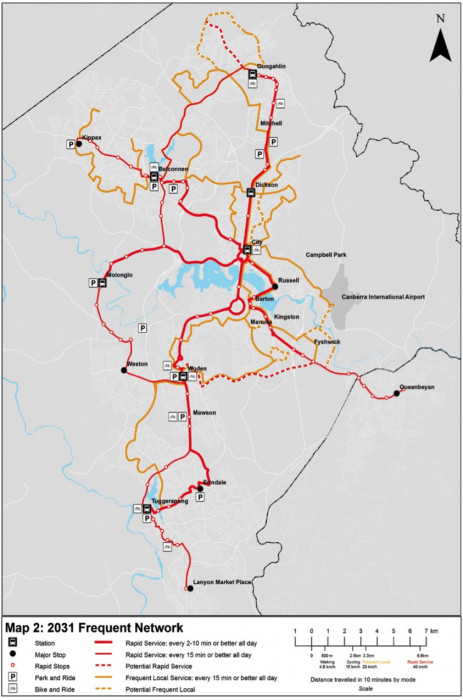
A key idea was to have a citywide network of Rapid buses, with widely spaced stops.  Our most ambitious map (below, click to enlarge) imagined four of them, shown in red, though only the two longest ones were to be implemented anytime in the near future.  We also proposed a local frequent network (orange) covering most of the city.

Canberra 2031 network envisioned in 2007

We stopped there because we wanted the plan to seem financially reasonable.  Still, we were clear at the time that we were creating a structure for growth.  We were not predicting what would happen in what year, but rather defining a network of services that would phase in as development and political support warranted.

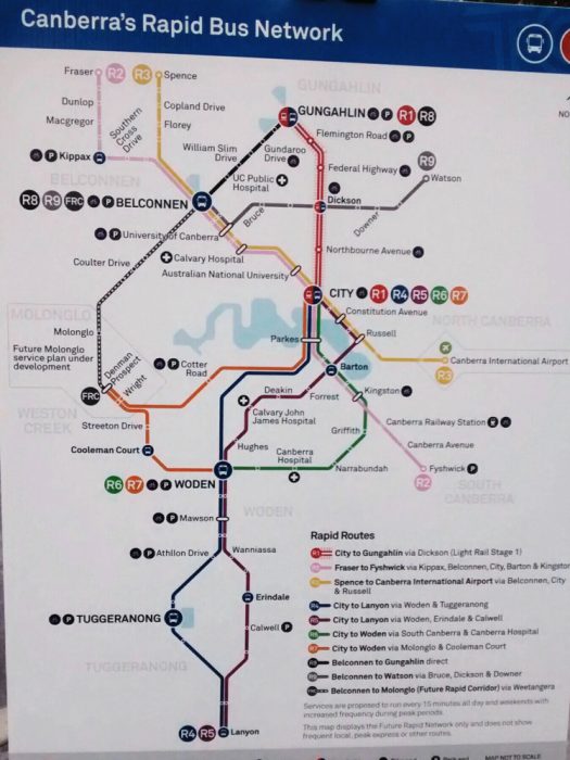
So it’s in the nature of such a plan that you’re creating a guide without knowing exactly how it will come out.  As it turns out, the plan has moved faster than I expected.  One Rapid line is now becoming light rail, but just as important, the government has announced a far larger Rapid network than we ever imagined, nine lines in total:

Canberra Rapid Network 2018

When a transit idea catches on locally, everyone wants it, so the next stage is often to deploy it beyond the range of where it can really succeed.[2]  So I wouldn’t be surprised to see this network pruned as ridership numbers come in, especially if times get leaner.  But meanwhile, the lesson is that great planning can lead to more money, if it starts to build a vision that people care about.  I don’t regret the fact that our plan’s vision, prepared 10 years ago, was more limited.  At that time, a more abundant plan would have seemed delusional.  You walk before you run, as they say.  We were walking 10 years ago.  Now Canberra is running.


[1] Public transport is the global term for what North Americans call transit.  I tend to use the word appropriate to the place I’m talking about, but I hope everyone understands it on both sides of North America’s moat.

[2] One of my concerns in strategic planning is to propose only a few corridors of high-level transit in the early years, so that there’s a motive for development to concentrate on them.  This effect is lost if that network goes too many places, relative to the demand for development.  The result is likely to be a more sprawling city.

Ready to Go — Without a Driver’s License

We’ve heard over the past few years that the driving boom is over in the US. People are driving less and a smaller portion of the population is choosing to have a driver’s license.

Michael Sivak and his colleagues at the University of Michigan recently released an update on the percentage of people with driver’s licenses in the US. In 2011, the original research found that the percentage of young people with a driver’s license decreased substantially between 1983 and 2008. What’s the latest on driver’s license trends? Continue Reading →

Access across America!

  Levinson cover

There should be nothing amazing about a new report on how easy it is for Americans to get to work on transit, but there is.   Think about all the arguments we have about transit …

… and ask: Why do we try to discuss these things in the absence of good analysis of the most basic question of all:  Is transit useful?  Does it help people get places in at a time and cost that's a logical choice for them?  Such information is often hiding inside ridership models, but it's rarely revealed in a way that lets people see and discuss it.  Without that, it's hardly surprising that the American transit debate is so confused.   

Access across America: Transit 2014, from the University of Minnesota’s Accessibility Observatory, describes how easy it is to get to jobs in America’s major metro areas by way of transit plus walking.  (For very short trips, it shows what can be reached by walking alone.)   The authors are Andrew Owen and Professor David Levinson.  The report is meant to sit alongside similar studies for the other transportation modes.

So here’s Portland, say, shaded by the number of jobs that can be reached within 30 minutes from each point in the city:

Levinson pdx
The report also offers a ranking of how easy it is to get to jobs for the average residential location in all the major metros.  The ranking looks at where you can get to in a range of travel time budgets, from 10 minutes – basically a measure of walk access – to as much as 60 minutes.  Here's are the top 17:

Levinson

As the travel time budget rises, the relevance of transit to economic opportunity becomes visible.   Los Angeles, with long access distances but extensive frequent transit, does poorly on 10-minute walkability but climbs in the rankings as you consider longer travel time budgets, thanks to its effective frequent transit grid.  Miami drifts in the other direction, signaling that compared to Los Angeles, transit there is adding relatively little to access to jobs beyond what’s achieved by walking alone.

Now here's what's amazing for a study pubished in 2014:  Owen and Levinson claim (p 6) that this study is unusual in properly accounting for frequency.  Many analysts approach transit from the point of view of the nine-to-five commuter, who was presumed to be largely insensitive to frequency because they have made an appointment with a particular scheduled trip that they take every day.   This sometimes feels right to bureaucrats and civic leaders, many of whom have such commutes themselves, but out there in the larger economy, more and more people work part time, or at irregular hours, or at times outside the standard commute peak.  Increasing numbers of people also value flexibility and spontaneity even in work trips — things that only a robust all-day frequency can provide.

Perusing these maps and rankings, my overwhelming reaction was “what if they’d analyzed it like this, or graphed it like that?”  A huge amount of insight is readily available out of this database if we query it differently.  For example:

  • Instead of ranking cities by the number of jobs reachable on transit in a given time, what if we ranked them by the percentage of jobs accessible?  The current rankings are still, predominantly, just a ranking by total volume of jobs.  Doing it in percentage terms will really pop out the winners in their size class, like Portland.
  • For the same reason, I really want to see Canadian cities ranked in this way.  They tend to have far more transit service per capita than comparable US ones, and higher ridership per capita as a result.  If this shows up in dramatically better economic opportunity and personal liberty, it could create a powerful contrast when cities compare themselves with similar ones across the border.
  • Why confine our attention to 7-9 AM, the classic morning commute peak?  There’s a good argument for starting there: it’s when the maximum number of people are trying to travel.  But the time-of-day dimension is essential to understanding the real lives of the majority of workers who are not peak commuters: those who work part time and in non-standard shifts, like almost everyone in retail, entertainment and manufacturing.
  • Let’s look at access to other things besides jobs.  All transportation studies overemphasize the journey to work because we have better data on it than on anything else.  But with the appropriate layer about locations, we can explore access to retail, access to food, access to education, even access to nightlife.   Regions may not have this data, but many cities do, and much of the interest in this tool will be at the municipal level.

Still, this is a great piece of work.  And Americans should pause over the core of this announcement:  Only now, in 2014, are we starting to study people’s ability to get where they’re going, and their opportunity to access all the opportunity that makes a great city.

indianapolis: a comprehensive transit plan

Canal_walk_IndianapolisI'm just home from Indianapolis, where our firm is beginning work on something called a Comprehensive Operational Analysis (COA) update.  The project is shaping up to be an important step in the transit vision for the city.  

Many parts of Indianapolis are seeing  a remarkable revitalization.  Dense housing is growing fast in and around the walkable downtown core, galvanized by public works like the Cultural Trail and a strong base of downtown parks, monuments,  state government, universities, and cultural institutions.  There are even canals lined with housing, much like the Dutch might build.

Many neighborhoods are also vibrant and growing.  The northern suburbs include Carmel, famous not just as the "Roundabout Capital of the US" but also for a very strong walkable downtown.  Carmel is the sort of massive suburban transformation that is common in the west coast and northeast but still unusual — in its sheer scale — in midwest metros of Indy's size.  The critical mass around walkable urban development  is clearly developing fast in and around Indy, making it an important city to watch especially for its midwestern peers.

Sometime in the next couple of years, voters will be asked whether they want to make a commitment to improved transit service.  That vision, called IndyConnect, includes a series of Bus Rapid Transit corridors but not much detail on how the total network would work.  Our study (for the regional planning agency, Indianapolis MPO, as well as the transit agency IndyGo) will help build a clear and costed set of scenarios for how the total transit network could improve, extending the benefits of the rapid transit element well beyond the specific corridors it serves and telling a story about benefits to the entire metro area.  (We also have a practical short term task, which is to figure out how to rearrange bus routes downtown to work with a new transit center opening next year.)  

There will be plenty of opportunities for public comment over the next six months as the planning process proceeds.  We look forward to lots of great conversations about this exciting and fast-changing city.

Photo: Chris Hamby 

portland: the grid is 30 years old … thank a planner!

Thirty years ago next week, on Labor Day Weekend 1982, the role of public transit in Portland was utterly transformed in ways that everyone today takes for granted.  It was an epic struggle, one worth remembering and honoring.

I’m not talking about the MAX light rail (LRT) system, whose first line opened in 1986. I’m talking about the grid of frequent bus lines, without which MAX would have been inaccessible, and without which you would still be going into downtown Portland to travel between two points on the eastside.  (Full map here.)

Portland grid\

What did it look like before 1982?  Here’s a bit of the 1970 network (full map here).

Portland 1970

The 1970 network consisted of bus routes radiating from downtown across the gridded eastside, which constitutes about 3/4 of Portland.  If you were anywhere on this network, you had a direct bus downtown — a slow, circuitous, and infrequent bus.  Very few routes ran better than every 30 minutes during the day.  Only two routes ran north-south across the east side, and both were too infrequent to transfer to, so you couldn’t really use them unless both ends of your trip were on them.

How did the 1982 network transform the possibilities of mobility in the city?

  • The old network was solely about going downtown.  The new network was about going anywhere you wanted to go.
  • The old network was infrequent.  The new network required easy connections, so it was designed to run at high frequency (most lines every 15 minutes or better all day).  Remember: Frequency is freedom!
  • The old network was wasteful, as many overlapping lines converged on downtown.  The new network was efficient, with little overlap between lines, and with lines spaced further apart to the extent that the street network allowed.  This is how the resources were found to increase frequency so much.
  • The old network was complicated, with routes often zigzagging from one street to another.  The new network was simpler, easy to keep in your head.  Many streets that were formerly served by a patchwork of overlapping routes, such as Division, now had a single route from end to end, so that you needed only remember “the Division bus.”  Transit became an intrinsic part of the street.

If you’re in a hurry, skip to “Thank a Planner!” below.  But if you have a couple of minutes, let’s explore more deeply how the grid transformed Portland, and why it was so controversial at the time.

In both maps above, that wavy line across the middle of eastside Portland is the Banfield Freeway, where the first and backbone line of the MAX light rail system runs today.  In the 1970 image, look for the line marked “1” extending north from the Banfield in the middle of the image.  This is NE 42nd Avenue (a bit of which is labeled 41st, but don’t let that distract you).

In the old network the bus line along 42nd came from the north edge of the city, once an hour.  Partway down it merged with another branch, to form 30-minute frequency.  When it approached the Banfield, it turned west and zigzagged into the city via the Lloyd district.  Once it turned west off of 42nd, it was duplicating other routes the whole way.  If you wanted to go somewhere else on the eastside, the bus was not much use.   Frequencies were poor so it was very hard to make a trip involving multiple routes.

If you lived on NE 42nd in 1982, you were confronted with massive change, the sort of change that makes people scream.  Never again would you have a direct bus to downtown Portland.  Now you would be on the new 75, which would run continuously north-south all the way across the city.  And if you wanted to go downtown, you would have to transfer (as we called it in those days).

But on the bright side, the 75 would run every 15 minutes, so transfering wasn’t hard.  And in return, you got all the other benefits of a frequent routes that would let you connect quickly to reach destinations all over the east and north sides of the city, without going downtown.

This is always a tough sell, because many people value transit only for the commute downtown.  These people tend to complain when the network is optmized to serve many kinds of trip at once, which is exactly what the grid does.  A frequent grid is the ultimate in versatilityequity and freedom.  It does not pick favored destinations for favored markets. Instead, it delivers anywhere-to-anywhere mobility for wherever you might want to go.  Today, the non-downtown elements of the grid, especially 72 and 75, are among TriMet’s most productive lines.

The grid redefined the role of transit in serving Portland’s livability objectives.  When you think of everything that makes Portland both livable and culturally distinctive, you’re probably thinking about the historically dense and gridded part of the city.  This is where almost every cool urbanist outcome of the last 30 years — from food carts to bike lanes to office-over-retail — has sprouted and thrived most successfully. Rail gets all the press, but the MAX light rail line would not have worked without this grid to connect with it.  (The reverse is not true: the grid worked well for four years before the MAX line opened, though MAX was certainly an improvement that achieved further ridership payoffs.) As Gregory Thompson and Jeffrey Brown put it in a recent paper :

If the 1983 and 1986 restructurings had not happened, LRT would have been a competitor with the CBD-focused, poor quality parallel bus routes that already were there, and there would have been no high quality bus routes intersecting the LRT at right angles. Portland would have enjoyed much less patronage than it has since experienced on both its LRT and bus routes.

Where did all the money for the new high-frequency crosstown lines come from?  Removing duplication. Look again at the your ride on 1970’s route 1.  Once it turned west off of 42nd, it duplicated other routes the entire way into downtown.  Now look closely at the routes approaching downtown from further south in the old map.  They ran on so many closely-spaced parallel streets that they were effectively duplicating one another as well, wasting service.  The grid plan found many resources by removing these duplications and moving to wider and more consistent spacing of lines across the whole city.  In the same process,the grid introduced the idea that it’s OK to walk further to a more frequent and useful service — the foundation for transit’s link with walking (and with all of walking’s public health outcomes) today.

The grid was also a radical simplification, making it easier for people to keep the network map in their heads.  Now, bus lines would often follow the same street from end-to-end, so you could remember easily that there’s a Division Street bus, say, and an 82nd Avenue bus.  In the old network, if you wanted to go from 20th & Division to 82nd & Division, you had to go downtown and back, because these two parts of Division were covered by different routes.  The beauty of the grid is that your transit directions are sometimes as simply as walking or driving directions:  “Take the Division bus out to 82nd, then take the 82nd bus south.”  The transit lines are just part of the street.

Imagine, in 1982, the struggle involved in implementing this.  Vast numbers of people lost their direct bus to downtown, at a time when going downtown seemed like the only purpose of transit to many existing riders.  Transit agencies tend to listen most to their existing riders, who have adapted their lives to the system as it is, so it takes real courage for them to seek new markets instead of just catering to the existing ones.   Imagine the disruption, the rage, the recriminations, not to mention the apathy from people for whom buses just don’t matter, no matter what they’re achieving.

Thank a planner!

If you can imagine how hard this was, consider thanking the planners who took all this abuse and persisted in pushing the plan through, because they believed in everywhere-to-everywhere networks and knew this would work if it were tried.  I’m especially thinking of:

  • Ken Zatarain, who was a TriMet service planner at the time and who is still at the agency.  Thank him at:  ken dot zatarain at wsp.org.
  • Thomas G. Matoff, the single most important mentor in my own transit career, and probably the critical player in pushing the grid through.  Tom, who was service planning manager and thus Ken’s boss, was an eloquent, passionate and persistent advocate for the grid both inside and outside the agency.  He was the first person I’ve met, and one of the few I’ve known, who could convey how essential network design is to the life, joy, and prosperity of a city.  Tom went on to be General Manager of Sacramento Regional Transit and is now working on the Sonoma-Marin rail project in California.  Thank him at:  tmatoff at ltk dot org .

I’m dead serious:  If you value being able to get around Portland in all directions, thank them.  In other words, do one of these things:

  • shoot emails of appreciation to the three emails above, copied to me (jarrett AT jarrettwalker DOT net), with “Thanks for the grid” in the subject line, or
  • leave a comment here, or
  • say something on Twitter with the hashtag #PDXGrid .

You might also ask the two mayoral candidates about how important the frequent grid is to their vision of the city, and whether they think it should be enhanced.

Why does this matter?  Because even today, there’s disagreement in Portland about important the frequent grid is, or even whether a complete everywhere-to-everywhere network (which requires high-frequency buses as well as rail) should be a priority at all.  Some view the grid as unimportant, for example, because they view bus service as unimportant.

Purists might argue that the grid never made it to its 30th birthday, but rather perished at 27 in 2009.  That was the year that TriMet cut all-day frequencies below the 15-minute threshhold that is widely accepted as the definition of “frequent enough that you can use it spontaneously, without building your life around the timetable.”  Since the grid relies on easy connections to achieve its goal of easy anywhere-to-anywhere access, the 2009 cuts began to undermine the whole idea of the grid. TriMet avoided doing this in its first round of cutting after the crash, but felt it had no alternative in the second 2009 round.

Will the grid ever be restored to its necessary frequency?  Will it ever be expanded and enriched (as regional land use planning generally assumes it must be) with even better frequencies?  Not everyone in Portland thinks this is a priority, so you might want to express your view.

More on the history and spectacular outcomes of the grid if you click below.  But even if you don’t click, thank a planner!

Continue Reading →
fort lauderdale: yet another triumph for multi-destinational networks

If your city is producing lousy outcomes with its bus services, are you sure it's because of the buses, or the drivers, or the sidewalks, or the degree of "transit oriented development", or that they're not streetcars?  Maybe it's because the network structure is obsolete.  A study team led by Gregory Thompson of Florida State looked at the success of Broward County Transit, which serves greater Fort Lauderdale.  Apart from a few special enclaves, Fort Lauderdale is unlikely to be high on anyone's list of urbanist paradises.  It has plenty of gridlock, plenty of pedestrian-hostile environments, and the usual abundance of oversized roads that seem only to generate more congestion.

Broward sidewalk campaignYet the hard-working if unappreciated Broward County Transit system is producing excellent outcomes through multidestinational design.  Instead of running a radial system into a single downtown, they decentralized to serve many destinations, through a network of routes making easy connections with one another. Eric Jaffe tells the story today in Atlantic Cities.

The whole case for this kind of design is in my book Human Transit, esp Chapter 12 and 13, but Thompson has been making it for years.  I'm impressed at how well it's working in not-especially-transit-friendly Florida metros.  Tallahassee took the plunge last year.

Obviously this is an issue close to my heart.  I came to consciousness as a transit planner during the decentralization of Portland's network in 1979-82, which created local pulse networks in each suburban area and culminated in the high-frequency grid that today covers most of the city.  Almost every network design I've ever done has helped to improve the multi-destinational utility of transit networks of all sizes.  Huge amounts of resistance have to be overcome.  But if they're designed well, they work. 

Finally, kudos to the folks at Atlantic Cities for coming back to this issue with one great story after another.  I'm not sure I've ever seen a major media outlet build up this degree of internal understanding about the fundamentals of transit network design — a topic that's easily forgotten while obsessing about how cool technologies are.   Is any other American media outlet dealing with network planning issues so clearly?  Certainly not the New York Times, which publishes one story after another in which well-meaning platitudes about social needs are proposed as ways to change the facts of geometry.

how do you compare to your peers? should you care?

Admit it:  You've always cared, at least in secret, about how you compare to your peers: your friends, your fellow students, your graduating class, your co-workers, your generation.  Well, deep down, transit authorities and city governments care too, which is why comparing a city to other similar cities always gets attention.

Sometimes peer comparisons cause complacency, especially if you choose the wrong peers.  Wellington has the highest transit mode share in New Zealand, but in a country with only one other big, dense city, that obviously shouldn't imply that it's reached nirvana.  Working in greater Vancouver I always have to emphasize that they are doing so well by North American standards that they have to start comparing themselves to European port cities in their size class (Glasgow, Edinburgh, Copenhagen, Helsinki, Marseilles).  My general advice: If your peer comparison says you're wonderful, throw a party and revel in this for 48 hours, then look for a more motivating group of peers. 

At the other extreme, nothing is more motivating than being told that you're dead last among your peers.  Earlier this year I worked (through my Australian employer MRCagney under the leadership of Ian Wallis Associates) on a peer comparison study for Auckland, New Zealand, which compared Auckland's transit performance with all the five biggest Australian cities plus a selection of North American ones.  Download the full report here.  Remember, if you're in any of the peer cities that it uses (Wellington, Brisbane, Perth, Adelaide, Sydney, Melbourne, Edmonton, Ottawa, Calgary, Vancouver, Honolulu, Portland, Seattle) this is your peer study too!  Just keep the tables and refocus the text (citing the source of course!).

More generally, the report is a good illustration of how peer comparison can work at its best, and also of the cautions that must be shouted from the sidelines once the conclusions take fire in the media, as they certainly have in Auckland.  From yesterday's New Zealand Herald:

Consultants have ranked Auckland last out of 14 cities – in New Zealand, Australia, Canada and the United States – included in a benchmark study for the average number of public transport trips taken annually by its residents.

Aucklanders also pay the highest fares of any of the cities, amounting to 24c for every kilometre travelled on the average 44 public transport trips they take each year, compared with 17c in Wellington.

The rest of the article is further grim statistics, plus quotations from political leaders demanding that something be done. 

I'm  sympathetic to Auckland Transport in this case.  Remember, a city's transit performance is mostly about the physical layout of the city and the constraints on other modes; the quality of the transit system by itself can't overcome problems in those areas.  The nature of the economy also matters.  Wellington is much smaller but it has much more severe chokepoints in its urban structure.  In fact, all travel between the northern and southern parts of the city must go through a single chokepoint less than 1 km wide, which is also the (very dense) downtown.  Wellington's economy is dominated by government, which is generally a sector disposed to use transit heavily. All of these features are hugely important in driving Wellington's mode share above Auckland's, and yet they don't include anything about the respective quality of the transit systems. 

Peer comparisons also carry the false assumption that everyone wants to be the same kind of city, and is therefore working to the same kind of goals.  (This attitude, taken to extreme, produces the absurdity of top ten "best cities for transit" lists.)  Low mode share for transit may mean your transit system is failing, but it may mean that it's not trying for mode share, or at least that it has other objectives or constraints that prevent it from focusing on that goal.  It may just mean that your city has different values.  It may mean the city stikes a different balance between cycling, transit, and walking based on its own geography.

Still, service quality matters, and there's a lot that Auckland can do.  I hope the city's opinion leaders are listening to Auckland Transport as well as berating it, so that they understand the real choices that must be made to move Auckland forward.  If there's a real conversation, great things can be accomplished. 

transit acceleration campaign goes national

For over a year now, Los Angeles Mayor Antonio Villaraigosa has been spearheading a "30/10" initiative, designed to accelerate the construction a range of urgently needed transit projects (mostly rail transit lines).  The key word is accelerate, not fund.  The projects are already funded, but on a 30-year timeline.  The 30/10 proposal would deliver the projects in 10 years.

The idea begins with Measure R, a 30-year sales tax increment approved by Los Angeles County voters in 2008 to fund a large package of rail transit improvements, including the Wilshire subway to the westside.  Villairagosa wants the Federal government to create a mechanism to bond this revenue so that it can be spent in one decade instead of three. 

Well, you can only get Congress interested if the same idea can be applied in many places, so predictably the Mayor and Metro are now presenting America Fast Forward, a national campaign to create a similar mechanism for any urban region that has already put funded projects in place.  Los Angeles Metro's blog Source covers it here, the Los Angeles Times's Tim Rutten opines here.  Here's a puffy PDF.

Because it relies on Federal financing rather than spending, and because the funding sources are local tax streams that are relatively stable, it's an approach that could potentially succeed even in lean times.

In a tweet, Cap'n Transit asked me:  Could it be used to build highways?  Yes, it looks like the same mechanism could be used, in theory, to fund any locally supported infrastructure.  I hope it will be constrained to transportation, and if it were constrained to voter-approved funding streams like Los Angeles's Measure R it could well usher in a new era of these measures, in which most voters could vote up or down on a set of plans knowing that if passed, all of them would be built and running in just ten years, soon enough to affect most voters' lives.