It’s been a long struggle, but Toronto’s Eglinton rail line is finally open. Now, the rapid transit network consists of the wide lines on this map, numbered 1-6.
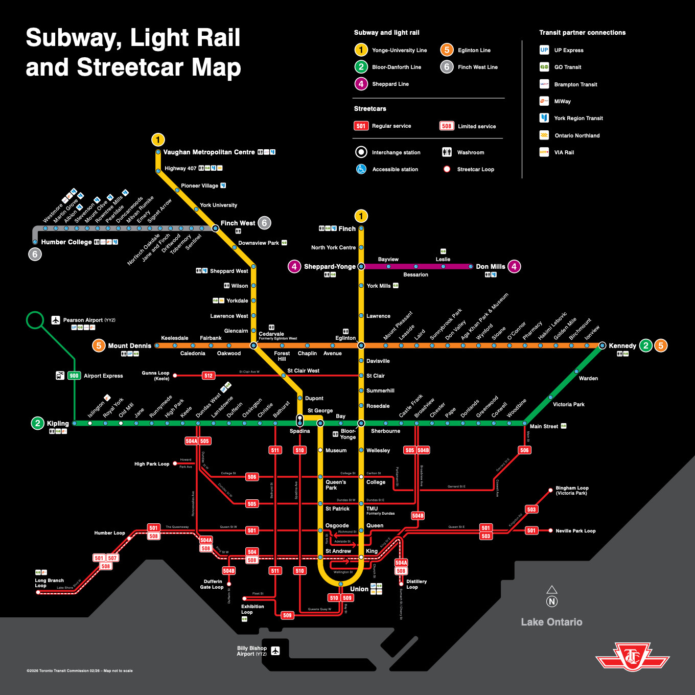
New rail map published by the Toronto Transit Commission, showing the new Eglinton line as Line 5. Please ignore the narrow lines numbered in the 500s. They are streetcars, and many of them are stuck in traffic and slower than buses.
The internet is full of reviews and recriminations about how long Eglinton took and the pros and cons of its design, but I want to make a different point: Eglinton shows a city slowly awakening to its true nature as a grid. This awakening is ultimately more important for the mobility and freedom of people in Toronto than details of what’s on rails and what’s on tires.
Toronto, like Chicago, is a grid city with a very uneven distribution of density. The city has a large grid of arterials that are more or less c0ntinuous across the city, but density is historically concentrated downtown and to some degree along the oldest rail transit corridors, especially Yonge (the east leg of Line 1).
So for a long time it wasn’t crazy for Toronto, like Chicago, to have a radial rail network (designed mostly for trips downtown) fed by buses that followed the arterial grid.
But it’s crazy now. Working from home has reduced the rush of commuters into the downtown towers. Meanwhile, many more towers are being built in the suburbs, often just over the line outside Toronto. And as in every city, the preponderance of travel demand is now much more all-day, all-week and all-direction than it used to be. Finally, lower-income people have always been less likely to be going downtown, and more likely to be accessing lower-wage jobs that are scattered all over the city. So if we care about them, we have to stop building and planning as though downtown is all that really matters.
So Toronto needs a network that people can use to go anywhere at any time.
The downtown-oriented network is not good at this, because by feeding toward downtown in a hierarchical pattern, it makes it hard to travel in non-downtown directions. In short, Toronto needs a grid transit network to match its grid geography, so that people can go from anywhere to anywhere in a simple L-shaped trip, usually with a single transfer.
Eglinton is the first major investment that shows a stirring of that consciousness. It lies well north of downtown, and runs east-west most of the way across the city. For the first time, it’s possible to travel a long distance east-west without transferring and without going downtown, which means that trips to many other places become possible with one transfer instead of two or three.
But the old consciousness is still on display further north on the map above, where the recent Finch West line (Line 6) has opened. It’s very much the old model of a hierarchical feeder, running from the west edge of the city only to the first subway connection. It’s now a mirror image of the equally problematic Line 4, which serves only a fragment of Sheppard on the east side. Both of these lines are largely useless for the kinds of trips that will increasingly prevail in a multi-dimensional city, because they interrupt the logic of the grid instead of working with it. My advice to Toronto years ago was not to build Finch West until they were ready to continue it all the way east at least to Yonge, the east leg of Line 1, so that it could also be used to travel to points on Yonge including northward into the dense suburbs. It will be interesting to see how useful the newly opened fragment turns out to be.
The buses, too, still display the old consciousness. Almost without exception, long east-west lines terminate at Yonge, requiring the passenger to transfer to continue in the same direction on the same street. Again, this means they will often transfer twice to complete an L-shaped trip to an actual non-downtown destination:
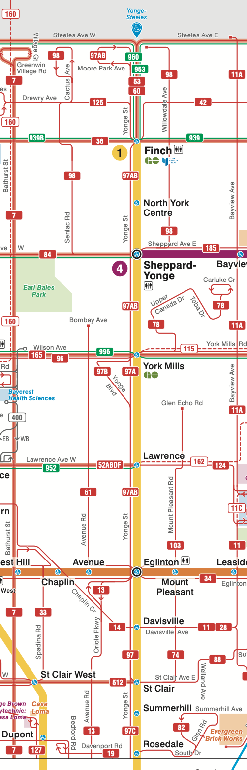
A segment of the Toronto bus map along Yonge Avenue from the north edge of downtown to the north edge of the city. Note that every east-west line is interrupted here. Eglinton rail (orange) is the only exception.
The situation is even more remarkable along the Bloor-Danforth subway Line 2, where again many bus routes are interrupted. Toronto is about twice as big east-west as north-south, so these corridors are shorter, which means there’s even less reason to interrupt them:
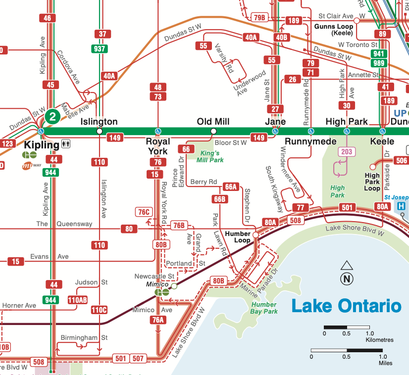
The west end of Line 2. Note that every north-south bus line is interrupted as it crosses the rail line, adding many unnecessary transfers to L-shaped trips that do not use the rail.
These designs reflect an obsolete notion of hierarchy in which rail is king and buses are servants, existing only to “feed” the rail. In an era when downtown commuters mattered more than anyone, that made a bit of sense, but only a bit. There were always people trying to go everywhere and struggling against these patterns. Now, buses need to be rethought to make sense on their own terms, as parts of complete grid networks. (Our firm brought the same awareness to the upcoming redesign of Atlanta’s MARTA bus network, where for the first time, many bus routes will continue past rail stations instead of ending there)
So amid all the other debates about Toronto, let’s celebrate the most important thing about Eglinton: For almost the first time, the city has made a major investment that recognizes that in a big, dense city, surrounded by dense suburbs, people need to go all directions, all the time.
At this point, the main problem in completing the grid is Dufferin. As it stands, Line 1 is way over-burdened, all the moreso now that it’s the main way you’re supposed to get downtown if you connect via Eglinton. The Ontario Line will help with this problem when it’s opened in a few years (indeed, that’s the point of the exercise), but something higher-capacity than the 7 bus will have to be built on Dufferin or Bathurst eventually, especially because the growth on the west side of town is not slowing down. My personal crusade is that it should go along College Street downtown to serve Toronto Western, U of T, and interchange with Line 1 at Queen’s Park (also serving the hospital district) At that point, you could start to see a true higher-order grid
This piece would have been filled by a leg of the Downtown Relief Line, no?
100% agree with making Sheppard line go to the old Downsview station and Finch W LRT should go to Yonge to connect line 1. Too many hops on and off to get to certain areas. This is why people are frustrated how this city has transformed the wrong way. Maybe this Ontario line will fix some issues out East/Midtown.
The Ontario Line which is what the DRL became is currently set to terminate at Exhibition, so it couldn’t run down Bathurst without doubling back on itself. There are plans to send it up Dufferin but I’m not sure about that – per the point about a grid above, it feels like it should be a separate line going east/west through the core to create another line on the grid.
A U shaped Ontario Line would just merge a few grid pieces into one line – let’s people travel through downtown on both ends. Would be very similar in network function to the Orange Line in Montreal. Regardless, we’re back to some of the bigger questions that have been missed in the battle-royale that has been transit planning politics over two decades in Toronto.
Jarrett, I live in Toronto and I would be happy to show you around if you ever visit. I think you’re speaking overconfidently about the city.
Eglinton is important, but it is essentially a circumferential line in a city that desperately needs more spokes. At the moment it only has two — the two sides of the Yonge line — since Bloor is also essentially a circumferential. The Yonge line south of Bloor is perpetually overcrowded. Luckily the under-construction Ontario Line (the future Line 3) will be another such spoke. Several of the GO (commuter rail) lines also have the potential to be useful longer-range spokes, if the province weren’t slow-rolling their electrification and modernization. (At the moment they are mostly too infrequent and have too few stops to be useful within the city, but at least the frequency is slowly increasing.)
There is effectively no distinction between the newly opened Line 6 and the thin red lines on Spadina and St. Clair: those also have their own rights of way, but are painfully slow. The difference on the map reflects an over-optimism that has become a scandal since the rather expensive line has been slower than the bus it replaced. This is entirely for fixable technical reasons, but both the TTC (the city transit agency) and Metrolinx (the provincial agency that built the line) seem woefully uninterested in transit speed, a point local transit activist Steve Munro has been harping on for a while; hopefully this will shake them a little out of their complacency.
As e.g. Alon Levy has written extensively, a transit city is a city with a strong core; everywhere-to-everywhere travel ought to be possible by transit, but privileges the car. Toronto was a small city in 1950, so the core is small but hyper-dense as towers sprout up directly replacing, and often incorporating, cute Victorian and early 20th-century houses and duplexes. Ours is not a 9-to-5 core; people live, work, and play there, and you should see the traffic at 8pm on a Saturday night. The metro area is sprawling and relatively hard to serve by transit, especially given how far behind we are in building it, but the base bus network is impressive by North American standards, at least within the city proper which accounts for a little under half the population. Nevertheless, this is not Los Angeles, the city is resolutely monocentric. Part of encouraging Toronto to become more of a transit city has to mean encouraging higher density in the neighborhoods nearest to the core, and pairing this with further transit investments into these easier-to-serve areas.
Fedor. I know those things about Toronto, but I disagree with that transit requires a *single* strong core. Paris, a vast medium density area with towers mostly on the edges, proves the point. Huge high-rise growth in suburbs just outside Toronto’s border means the city is continuing to grow more decentralized with multiple dense cores. Toronto needs it all, more radial capacity, but also much more of a grid flowing through to the suburban highrise nodes. When the grid doesn’t function, it forces people to make radial trips that don’t want to do that, making the radial capacity problem worse.
No, Paris does not prove the point. The whole city of Paris has enough density to support good transit from everywhere to everywhere within the city. Therefore, Paris can be considered single-core in this context.
Outside of downtown, Toronto has much lower density than the city of Paris. The density is enough to support good transit from everywhere to downtown, but not from everywhere to everywhere.
In fact, someone already made a map to illustrate this comparison:
https://blogto-production2-baselayer-display.blogto.com/upload/2015/07/2015714-Paris_Metro_in_Toronto_big.jpg
That is not totally true. Paris is a very centralized city with over 1 million jobs in the “central business district”, in the old centre of paris, plus another 250,000 to 300,000 jobs in La Defense (which people think if the CBD), and the jobs in between. This totally outshines any North American city for centralization of jobs.
London is even stronger. Something like 1.5 million jobs in central London.
“a transit city is a city with a strong core; everywhere-to-everywhere travel ought to be possible by transit, but privileges the car.”
Yet the city that is based around everywhere-to-everywhere travel — the city that has by far the best grid in North America — is dramatically outperforming its size when it comes to transit. When it comes to transit, Vancouver is kicking ass, and it hasn’t even finished the Broadway Subway yet! Nor has it gotten around to building the gondola to Burnaby Mountain (by far the best place to put an urban gondola in North America). It does not have a particularly strong downtown area and the subway lines don’t do a particularly great job of serving it. Yet Vancouver is one of the most productive transit cities in North America precisely for the reason Jarrett gave: They have a very good grid. You can get everywhere-to-everywhere using the combination of a bus and train.
Toronto is just behind the times. They haven’t quite wrapped their head around this idea — that people are willing to use transit for trips that don’t involve downtown. Yes, the light rail is way too slow. That is beside the point. The idea is solid even if the implementation is poor.
“Toronto is just behind the times. They haven’t quite wrapped their head around this idea — that people are willing to use transit for trips that don’t involve downtown.”
This is a problem with many North American transit agencies.
Also, regarding L-shaped trips that don’t use rail: the subway being faster and very frequent, they will often be faster as two-transfer trips that do use rail. The rationale for breaking up the bus routes (as I’m sure you know, but maybe it will help other readers if I mention this) is that it’s easier to avoid bunching on a shorter route. (Bunching is still a huge problem, though.) I occasionally ride the 72 Pape line, and while some people do stay on past Bloor, the bus largely empties and re-fills at the subway station; this effect is going to be more pronounced further from downtown.
Yes, route length is an issue in every network redesign we do, and agencies (and unions) differ enormously about what’s acceptable. But I pointed out the way north-south routes are broken at Bloor-Danforth because route length isn’t the problem in those cases. The segments between there and the lake are far too short!
“Also, regarding L-shaped trips that don’t use rail: the subway being faster and very frequent, they will often be faster as two-transfer trips that do use rail. ”
But isn’t that an argument against your first point? You say that Toronto is very strongly centered. Everyone is just trying to get downtown. But now you are say that riders are willing to ride the subway all the way around — they aren’t even heading downtown. This no doubt contributes to the crowding problem you mentioned. Oh, if only there were a solution to this vexing problem. Oh! I know! How about making the buses (and trams) faster?!! Crazy, I know. But the sort of thing that is common throughout the world.
Yes, the subway is frequent but nothing beats the frequency of just staying on your bus/tram a little while longer. The maps don’t show scale. Someone might assume that there is a huge distance separating the ‘U’. There isn’t. The southern section is quite narrow — less than 800 meters apart. As the ‘U’ widens, the distance grows — to about 1800 meters at Saint Clair. But at that point “rounding the horn” takes a while. Likewise, even at Cedarvale/Eglinton it is only about 3 km. It shouldn’t take that long to go across — and if it does, that is the problem (not the network design).
Again, at worst this is a good idea with bad implementation. But it is definitely a good idea.
There’s no contradiction here. Yes, Toronto is strongly centered. Yes, people still need to make trips not centered on downtown. It’s just much harder to make those trips the central focus of a transit system.
Yes, the buses and trams can and should be faster. But ultimately grade-separated rapid transit is how you get real speed and convenience in a congested city. The recipe for getting people to choose transit over cars is
(rapid transit where the largest number of people need to go
+ good enough transit where people sometimes need to go).
The latter is where the grid is really useful. But in a strongly centered city, it’s easier to serve a larger percentage of trips with the former.
Grid segments can also help people get Downtown, too – Eglington serves crosstown trips and gets people Downtown, but via a transfer. And you can have a grid plus some radials to more directly serve downtown oriented trips.
Toronto really needs more of almost everything, which is one of the challenges.
Poor Scarborough. Before amalgamation it was the 4th largest city in Canada, yet only merits 2.5 subway stops after all this time. (Victoria park is on the border). If we stop considering Yonge street as the centre of Toronto and show all of Toronto in published maps, one starts to see how under serviced it is. Try getting from Malvern to downtown. Why did the Eglinton LRT end at Kennedy. Try taking a bus east from Kennedy during rush hour. Why wasn’t the Sheppard line expanded eastward through neighbourhoods just as dense as North York and Etobicoke? What a shame.
I have lived in toronto for 62 years and you get it. We have been obsessed with this idea that everybody wants to go to Union Station or somewhere within a few blocks. This defies modern reality. Travelling east/west in Toronto is a pain and slow. No wonder many drive to their jobs near the airport from Scarborough. Its like nobody at the TTC and Metrolinx could fathom that somebody might want to travel east west. Even when I drive from the west end on the 401 to the east it still takes 35 minutes. Imagine that on a bus. Finch is a failure. The Crosstown should have been a subway but finally there is an east west line reasonably close enough to my house so I have a new somewhat fast route over to the JCC or Aga Khan. I dont have to drive. Its an incredible feeling. Dont let nabobs get to you, you get it says this lifelong Torontonian.
“Note that every east-west line is interrupted here. Eglinton rail (orange) is the only exception.”
Not true, 939B and 996 is not interrupted. They both have all-day service monday to friday every 12-15 minutes. 939B also has weekend service.
Note that “939” in the map means “all branches of 939”, including B.
Toronto 1980 was a peaceful and charming city but the later leap into 21st century has turned it into multiple agonies…It is still busy growing and expending? I think founding new cities would be sober and individualist but many are out to say we got to have bigger cities as they are better to feel in and manage…I don,t buy like a city that in people know each other? This will be a failure as people’s like moving out to live in nature not in boxes and noise? TTC is still the better way managing intelligently the crowd but one day all shall be hand up with no remedy in offing?
actually, i have been thinking about extending line 4 alone the proximity of hwy 401 so that it’s no longer a line 1 branch line, but a fast (large stop spacing) and anchor east-west main line for northern toronto. It would probably reduce congestion on 401, serve pearson, north etobicoke, north york, and northern scarbourough.
Our only hope is to get rid of Metrolinx. Or this bunch of political appointed incompetents will give us more up express, down express and everything in between. Don’t know why we can’t extend our underground subways with all the modern equipment at our disposal
It isn’t lines 1-6, it’s 1&2, 4-6, as line 3 doesn’t exist
Jarrett,
I understand your comments, but I think you are not fully grasping the layout and travel patterns of Toronto.
Should some buses continue past subway stations, instead of splitting into two routes? Sure. But, these bus routes are already long and need to end at some point for reliability. Further, even on routes that do pass through stations, most riders get on and off at the subway. What would really change crosstown travel, is more highway express buses for crosstown trips. No one wants to sit on a bus, or even the subway, for an hour, to cross the city, when you can drive it in 20 minutes in the car.
In fact, while the traffic does not make one think this, and yes, there are thousands of people going across the city each day. The fact is that the majority of trips do not cross Yonge Street, except in the downtown core. Again, this does not mean that we don’t improve crosstown service. But, the bus system does reflect, to some degree, the travel patterns.
Toronto does not focus transit on the downtown core. The entire system is a grid route system, including the buses. Toronto has the highest suburb to suburb transit mode share in North America, with upwards of 20% of suburb to suburb trips occurring on transit. That is nothing to sneeze at.
Also, the downtown is far from diminishing. In 2025, downtown Toronto had the highest employment levels on record, with almost 100,000 additional jobs than in 2019. Many companies are moving their offices from suburban areas into downtown. To keep the city healthy and the economy growing, we cannot ignore downtown travel. No matter what we do to crosstown transit, downtown will always be the king for transit travel. And we have to stop promoting the sprawl of jobs and people, because, no matter how many subways we built, it is useless if we don’t focus jobs both downtown and in suburban nodes.
So, Eglinton is not as revolutionary as you think. It is part of a network of grid rapid transit routes going back to the 1970s and 80s. In fact, one could say Toronto needs to focus a little more on providing some more radial services to downtown. There are bus routes that end at the Lakeshore, for example, which should just operate express to downtown.