Silicon Valley

Santa Cruz County: A Growing Transit Agency in a Beautiful Place

While you’ve heard plenty about big US agencies facing a “fiscal cliff,” some agencies are doing well and expanding their offerings as their staffing permits.  That includes Portland and Dallas, where we’ve been working, but here’s a similar story from a smaller agency in an outrageously beautiful place.

Santa Cruz County, just south of the San Francisco Bay Area, is known for its beautiful beaches, towering redwoods, college-town ambience, and expensive housing, but the county also contains Watsonville, on the edge of the agricultural Salinas Valley, which has cheaper housing and is over 80% Hispanic or Latino/a.  The University of California at Santa Cruz (UCSC) generates huge demand to its hilltop campus at the west end of the region, but Watsonville generates strong demand for travel both locally and to jobs in Santa Cruz.  Meanwhile, the City of Santa Cruz is trying to encourage denser housing along frequent transit corridors in order to address their problems of housing affordability.

Like many US agencies, Santa Cruz Metro had to make cuts during the pandemic to match the service to their shortage of bus drivers.  In the last year, though, the pace of hiring has picked up, and the agency can do its first substantial expansion.  They asked us to analyze the network and develop some concepts for improvement.  We drafted a couple of alternatives, and had a public conversation about them.  Finally, last Friday, the agency’s Board adopted a Phase 1 restructuring plan. By then, it turned out, hiring had gone even better than expected and some hard choices that we had feared would have to be made turned out not to be necessary.

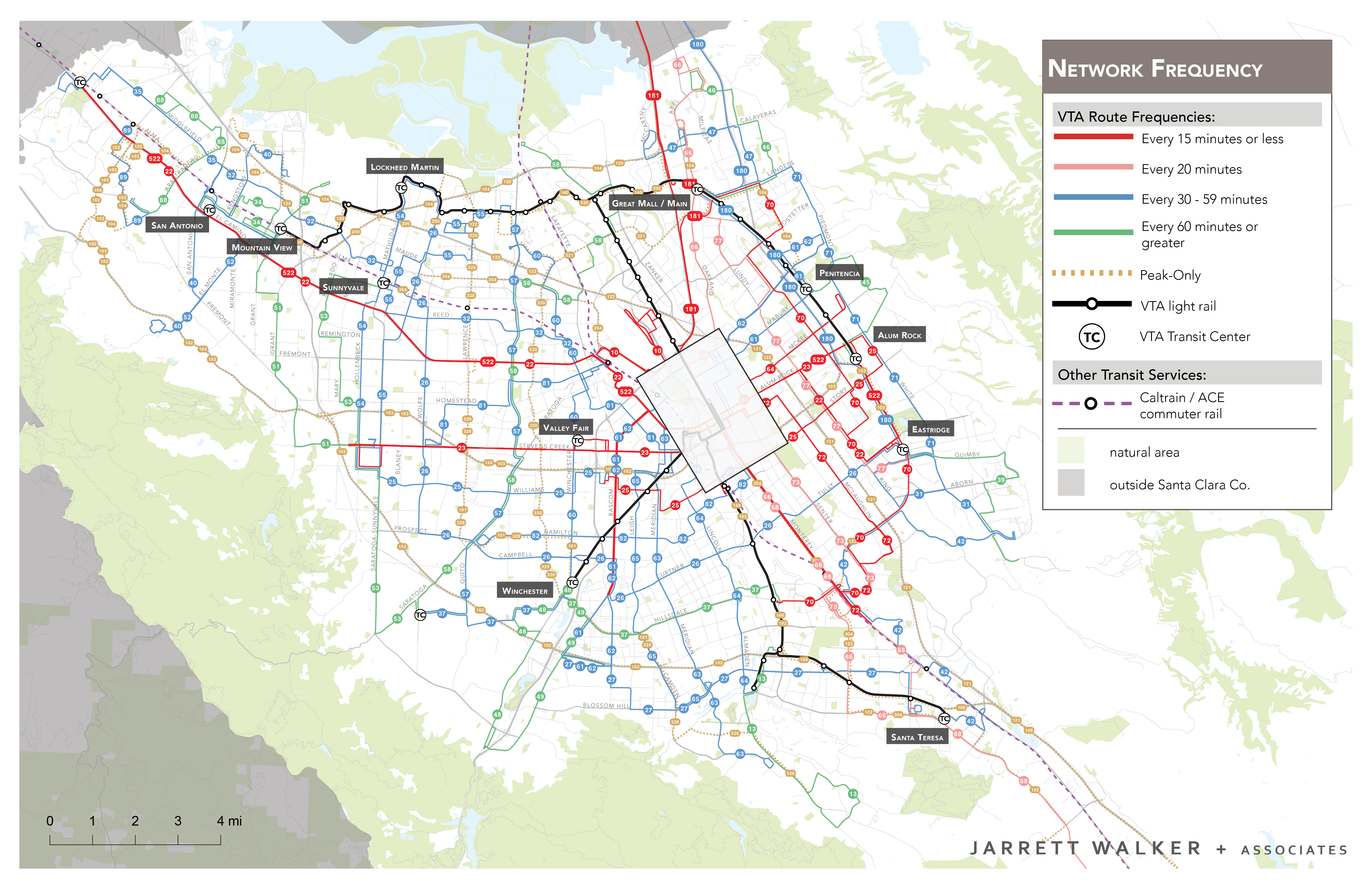
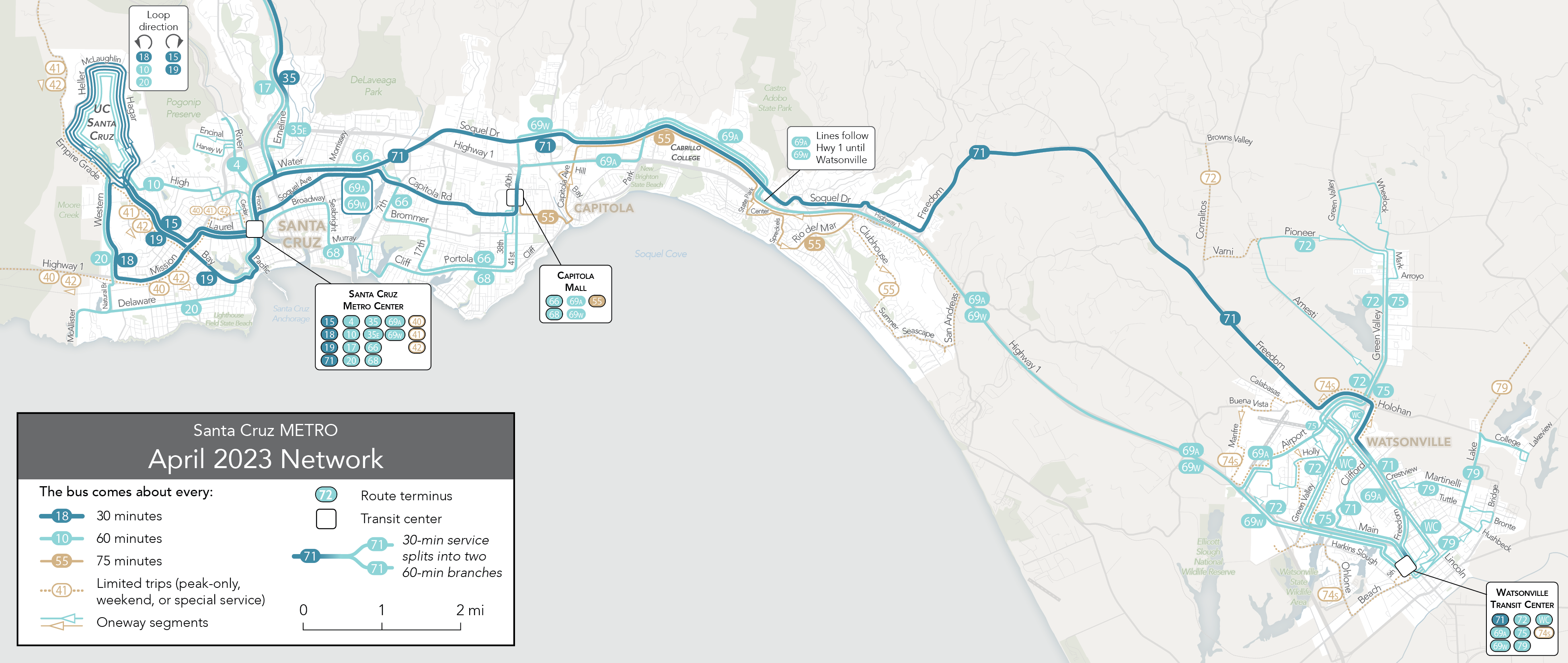
Phase 1, now scheduled for implementation this December, will change the network completely.  It currently looks like this.  (As always, click maps to enlarge and sharpen.)

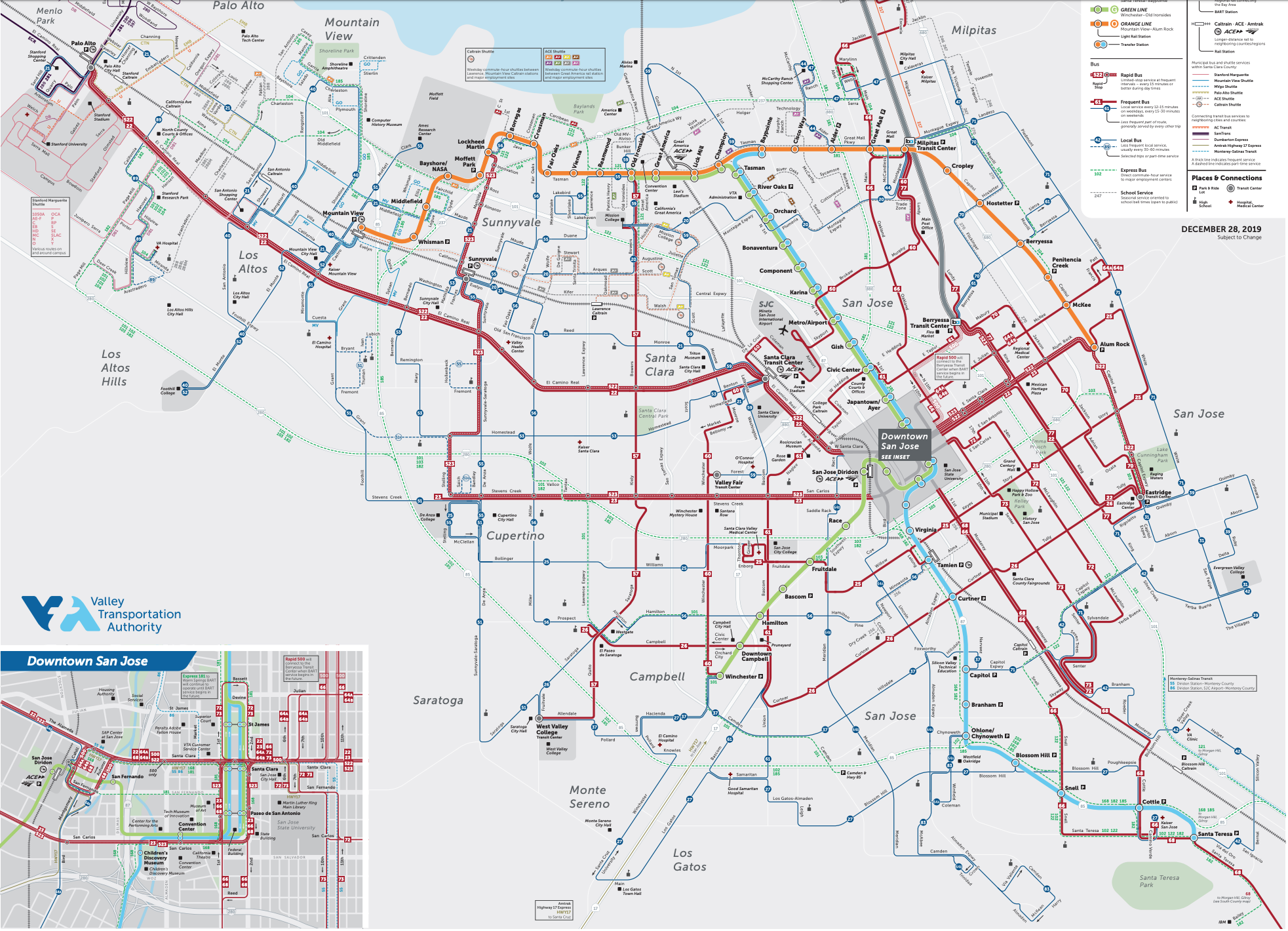
Starting in December it will look like this.

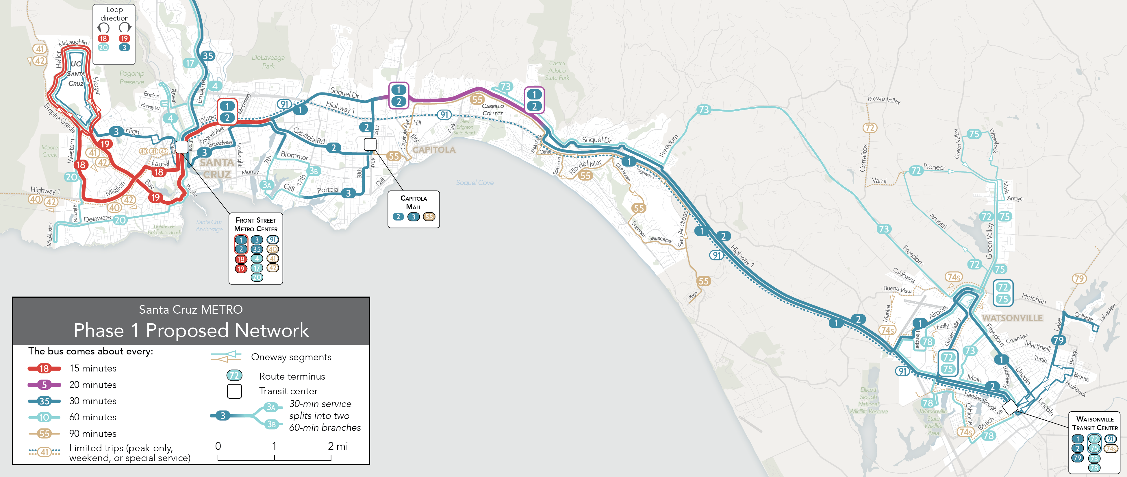
Look at the legend! As always, colors on these maps represent frequency, and that’s fundamental to understanding how this network is better than the old one.

The existing system has no service running better than every 30 minutes, but it also has no timed connections, so waits are long, not just for your initial bus but also for the bus you may be connecting to.  The redesign increases frequencies, improves the timing of connections, and streamlines and simplifies the network.

It’s an especially big change in Watsonville, whose confusing tangle of overlapping hourly routes was especially useless for most trips.  There, service is restructured to put a majority of the population and jobs near half-hourly service, mostly on lines that run through to the other cities to the west.

In Santa Cruz, the big change is the restoration of 15-minute frequency on the main lines that connect the University of California (“UC Santa Cruz” on the map) with the westside and downtown.  This is important not just for the university, but also to support the City’s goals for denser residential developments in the existing neighborhoods south of the campus.

The spine of the network linking Watsonville and Santa Cruz is a braid of four hourly routes currently called 69A, 69W, and 71.  In the new network the same resources go into simpler routes 1 and 2, and they’re more precisely scheduled to provide a 15-minute frequency on their westernmost segment where they run together.  Halfway between Santa Cruz and Watsonville, these two routes combine again to serve Cabrillo College, the only community college in the county.  We have shown the frequency there as every 20 rather than every 15 because if Routes 1 and 2 leave downtown Santa Cruz spaced evening every 15 minutes, they won’t be as evenly spaced at Cabrillo College, since Route 2 will have taken a longer path.  Still, this is a significant frequency improvement for the county’s biggest transit destination outside the University.

Santa Cruz Metro is rolling out this change very fast, aiming to have the new service on the street in December.  Meanwhile, this is just the first phase of a more ambitious expansion that will be discussed with the public soon in hopes of further frequency expansions in 2024.  That next phase would extend high-frequency local-stop service to Watsonville, while also adding an all-day Santa Cruz-Watsonville Express.  It will also look at new continuous service from the University to the east side of Santa Cruz.  We look forward to a robust public discussion of that next phase.

At our firm, we are ready to help any transit agency work with its financial situation, whatever it is.  But it’s especially exciting to see a transit agency that’s able to grow its services to match the values and ambitions of the communities it serves.

San Jose and Silicon Valley: Welcome to Your New Network

Finally, the long deferred new network design for Valley Transportation Authority — which covers San Jose and much of Silicon Valley in the Bay Area, is going live as I write this, on December 28, 2019.  The plan arises from a major study that we led in 2016.

[Implementation was delayed so long due to delays in completing the BART rapid transit extension from the East Bay into San Jose, which the plan is intended to complement.  VTA planned on the line opening tomorrow, but a last minute delay (too late for VTA to postpone their plans) has pushed that opening into the spring, so express buses will be providing that link in the meantime.]

What’s new?  A massive high frequency grid covering most of San Jose, where transit demand is highest, but also bit improvements for the “Silicon Valley” area to the west.  A new frequent north south line runs through Sunnyvale and Cupertino.  Routes are simplified and made straighter. The light rail system was redesigned at the same time, to make it more gridlike as well.  Nothing new was built, but the service pattern is also more of a grid, with a new continuous east-west line across the north side of the region that will connect tens of thousands of jobs to BART for travel to the East Bay.

Here’s the old network, with red denoting high frequency.  (Click to enlarge and sharpen.)

The old VTA network. Red = 15 minute frequency or better. Note the lack of a high frequency grid apart from the lowest-income area in the far east. Map by Jarrett Walker + Associates.

And here’s the new one, by our friends at CHK America. The style is slightly different from ours, but still, high frequency is in red, and the broad colored lines (black in our map above) are the light rail network.

The new VTA network. Red=15 minute frequency or better. Map by CHK America.

Also, an historic event about which I’ll write more:  A two-segment very low-ridership light rail segment has been closed, between Ohlone/Chynoweth and Almaden stations in southern San Jose.  I believe this is the first time that a modern US light rail segment — i.e. built since the 1950s — was permanently closed, with the exception of a single station in Pittsburgh.  (Please correct me if I’m wrong!)

And yes, some low-ridership segments disappear, though very few people end up losing all of their service.  Often, the deleted routes provided some link inside an area that already had other service, and while some of these routes were fiercely defended by locals, there was no way to justify them when they achieved neither high ridership nor unique coverage.  Another important part of that story is that many of the wealthier Silicon Valley cities have their own transit services, and while of course they would prefer that the county pay for their service, they have the option of running some of these low-ridership links themselves if they decide it is important to them.

Meanwhile, the center of gravity of the network remains in the east, not just because incomes are lower there but also because the geography is more favorable to efficient transit, with fewer barriers to walking and a more regularly gridded street network.  Google’s move into the Diridon station area of San Jose is a great first step toward bringing jobs and prosperity into a landscape that efficient transit can serve well.

All this resulted from a clear discussion with the VTA Board, and the community, about the ridership-coverage tradeoff.  The old system was about 70% justified by ridership, while the new network is closer to 90%.  Getting to the right balance of ridership and coverage goals was the result of a long conversation, in which we showed the public alternatives and got their feedback before the Board made a decision.

To all of Silicon Valley and San Jose, welcome to your new network.  It’s been a long struggle (for VTA more than for us) but you can finally go places you could never go before, and soon.


Google’s “Grand Central of the West”

Google and Apple continue to be a story of contrasts, and their latest development moves are no exception.  As Apple completes a new inward-looking space-age fortress in a largely transit-hostile location, Google is planning a huge campus right at Diridon station on the west edge of downtown San Jose, with up to 20,000 employees.

google sj

Google has its eye on the middle of this area in downtown San Jose, California. Note Diridon Stn on the left, LRT line running through, and existing fine street grid. Most of downtown San Jose is just off the map to the right.  Lots of frequent bus service too!

Under current plans, Diridon station will eventually have frequent rapid transit up both sides of the bay (Caltrain on the west to San Francisco, BART on the east side to Oakland and Berkeley).  It’s also a major hub in the local transit network (which we take pride in helping to design).  It is clearly on its way to being the most transit-accessible location in the southern half of the Bay Area.

Google’s current Silicon Valley situation is, frankly, a mess.

google in mv

Google’s self-inflicted transportation mess, Mountain View and Sunnyvale, California.

The company occupies a collection of office parks gathered around various sides of the obstacle of Moffett Field, a military and NASA installation.  This obstacle creates a chokepoint where east-west traffic is all forced down to the 101 freeway, increasing congestion there.  So traveling between Google sites, even over a distance of a mile or two, can be a pain, regardless of whether you drive or take a Google shuttle.

Google’s current locations on the north edge of the valley also form part of the Great Silicon Valley Jobs-Housing Imbalance — jobs are mostly in the north and residents in the south — which creates unmanageable south-north congestion.  And of course Google must also run a huge fleet of buses to bring staff from San Francisco, where many of them want to live.

Many newer startups — like Twitter, Uber, Lyft, Salesforce — have decided that to attract urban talent they have to move into San Francisco — great for transit and walkability, great for their top talent who live there, not so great for lower level employees who can’t afford to live within 20 miles of their job in one of the most expensive cities in the world.

Meanwhile, San Jose has just been sitting there, right adjacent to Silicon Valley, with a historic downtown that has great bones but could use more investment.  Inner San Jose is a pleasant, walkable, historic city that non-elite techies can afford to live in, and that still offers good transit access to the rest of the Bay Area.  Adobe, to its credit, is already there.

So bravo.  I hope this is opens the floodgates to more employers relocating in the most transit-oriented place in Silicon Valley.