We’ve been working for over a year with VTA, the transit agency of Santa Clara County, California, on a rethinking of their bus network. After a long process that has included multiple alternatives and a round of public discussion about them, we’ve arrived at a recommended network. The plan is meant to go in this fall, when a BART rapid transit extension opens into the county from the north, and when a rearranged operating plan for the light rail system is also planned. If you live in the County, or use the system, please tell VTA what you think. As always: if you like the plan, you should assume it won’t happen unless you tell the agency that you like it.
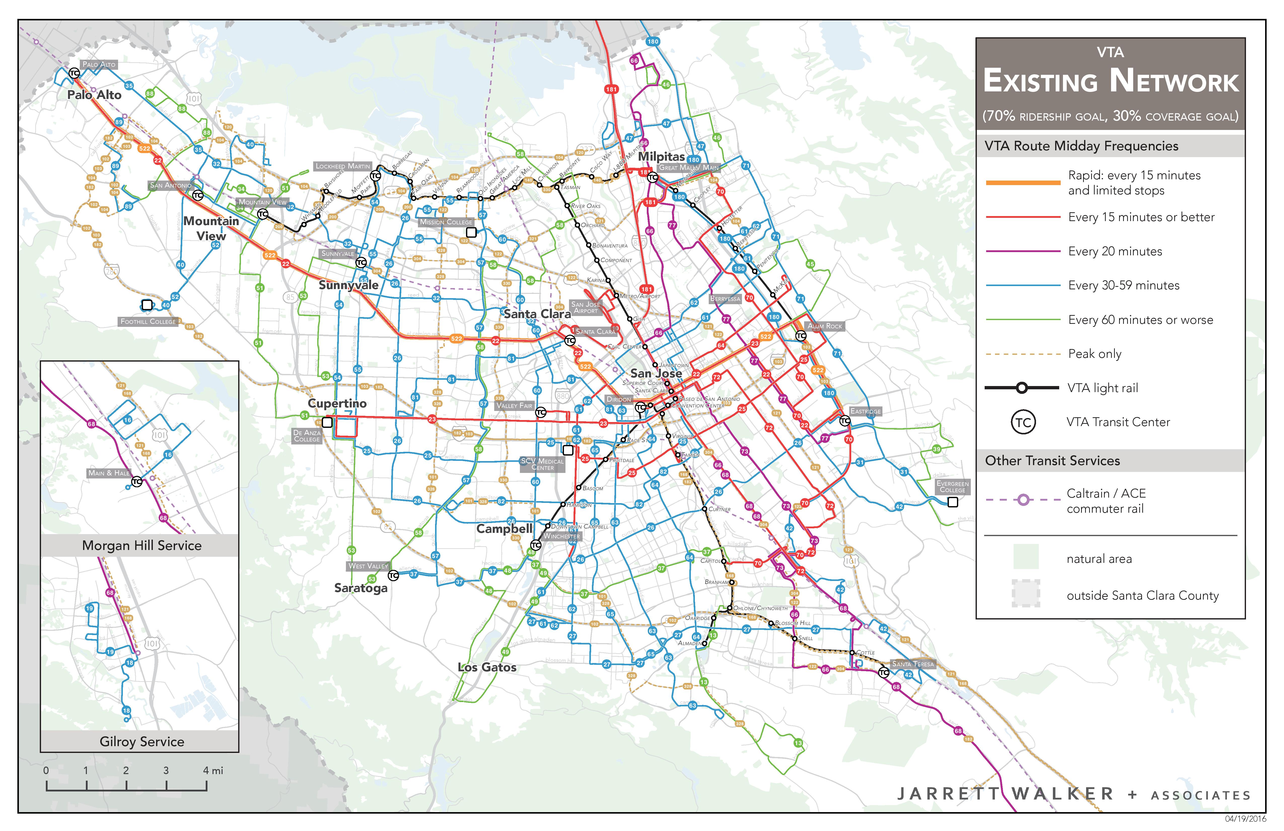
So here’s the system as it looks now. (Look carefully at the legend. Right-click and open in a new window for more detail.)
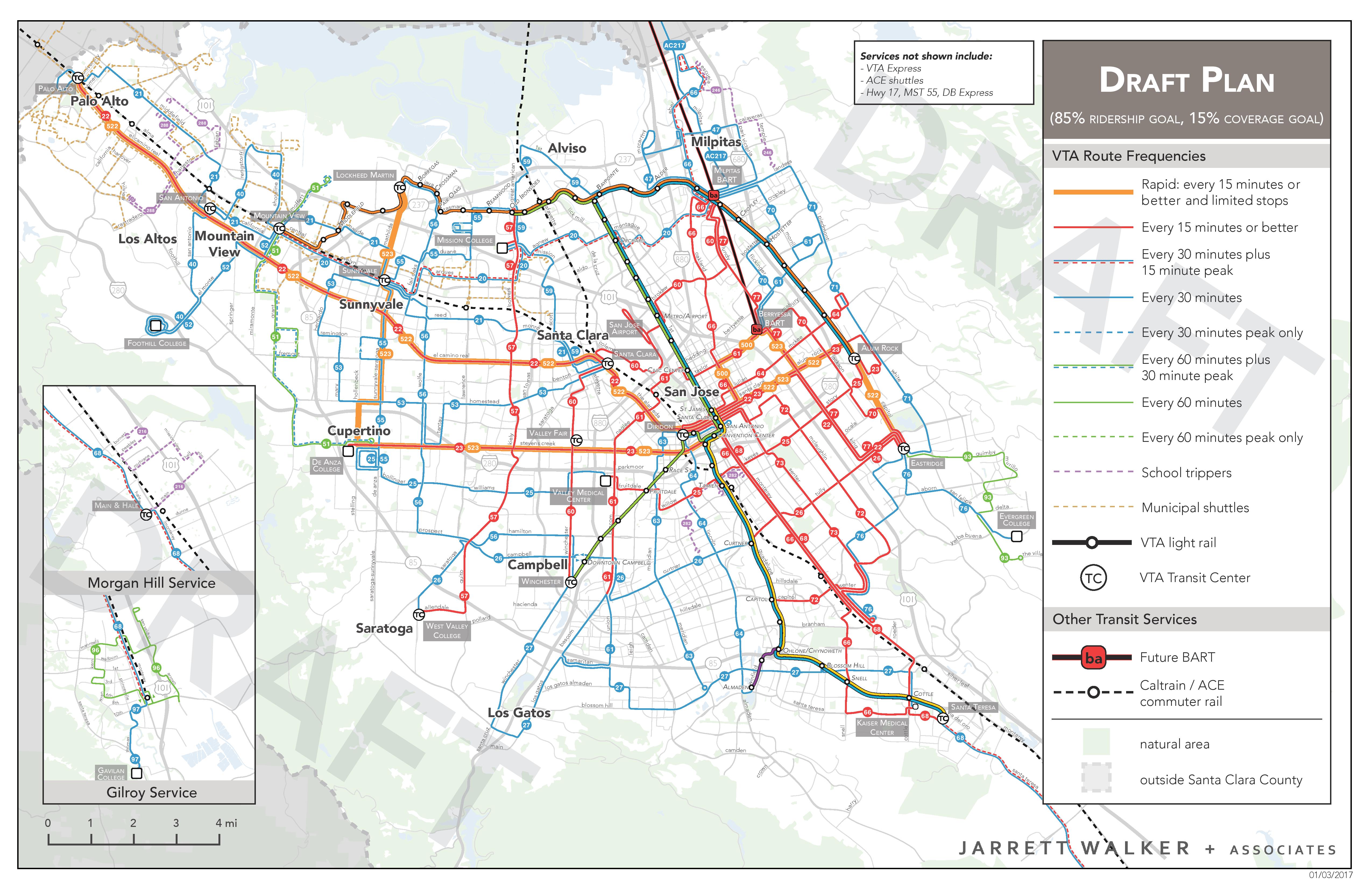
And here is the proposed network:
Here’s why the plan looks as it does.
- The plan before the public does not significantly increase the budget for bus operations. That means existing service has been re-arranged, which is part of why difficult trade-offs are made. County voters just passed Measure B, which has some additional funds for service, but those funds are not shown in the above plan. The Board could decide to add some of these funds to create the final plan.
- A goal of the plan is to shift the percentage of resources devoted to high ridership service from 70% to 85%.
- That means that the amount of resources for low-ridership coverage services — services that exist because some people need or want them but which not many people ride — goes from 30% of the budget to 15%. (For background on ridership-coverage trade-off, see here.)
- So in round numbers, the amount of coverage service drops by half. You see this in the many areas that have a blue or green line in the existing system but no all day service, and in some cases no service at all, in the proposed.
- The policy to devote 85% of resources to high ridership service, and 15% to coverage service, is not something we recommended. It was the result of an extensive public conversation about different paths the network could take. In the spring we presented three alternative networks to the public, showing this range of possibilities, and the 85-15 policy is the result of that conversation.
- Where coverage service has been eliminated, it is because of very low ridership, usually tied to low density or difficult geography (see here for the geometric principles involved). The plan does not discriminate between different parts of the county in this regard. Every city in the county has one or more coverage segments disappearing.
- Everyone at the agency, and everyone on the the Board, knows that some people will be mad about the coverage service cuts. If you are unhappy about this, please tell VTA that in your comments, but be civil, because civil comments are much more effective. Don’t tell us that we’re idiots or monsters (we’re not) or that we don’t know that people will be affected (we do). Understand that the service you are defending is very expensive per passenger for the taxpayer, because so few people ride it. Cuts to that service are not an expression of an opinion about you.
With that, here are some cool things about the plan.
- A much-expanded frequent grid. Eastside San Jose has always had one but now the same principle is spread across most of San Jose and a few main lines in the western part of the county, where demand is lower but where there are concentrations of all day demand that could support a grid pattern.
- A new Rapid Bus line, which means a line that runs every 15 minutes or better all day but makes widely spaced stops (up to 1 mile spacing). This one runs from the new Berryessa BART station through downtown and out Stevens Creek to Cupertino, then north through downtown Sunnyvale to the Lockheed area.
- Weekday hourly frequencies (green) are almost gone. If a route runs at all, it runs at least every 30 minutes.
- San Jose Airport gets a very different kind of service. Currently it has just a shuttle to light rail and Caltrain. This means you may be two connections away from most places you might be going. In the new network, the airport is on a line that runs all the way across the county, including directly to BART. That means fewer connections with your luggage. Much of the county, and much of the BART system in the East Bay, is just one connection away.
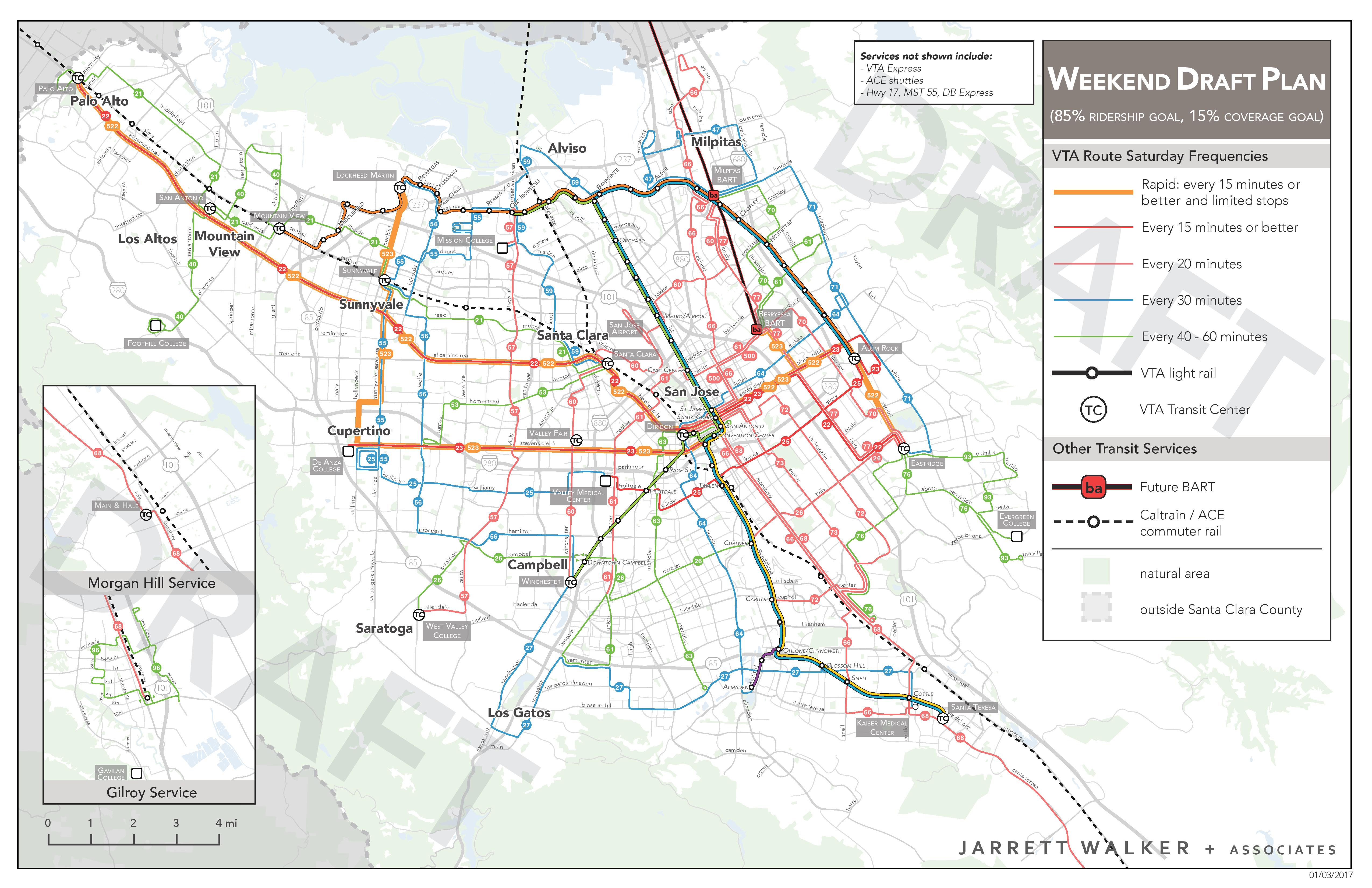
- Weekend service is especially improved. Here are the frequencies for the weekend network:
Once again, this draft plan is the starting point. The final plan, based on your comments and on board direction, will be adopted in April, and implemented this fall.
Nothing happens when I click on the images.
You need to right-click and select “View image”
Image URLs:
http://humantransit.org/wp-content/uploads/VTANextNetworkDraftPlanWeekdayWeekendExisting-page-003.jpg
http://humantransit.org/wp-content/uploads/VTANextNetworkDraftPlanWeekdayWeekendExisting-page-001.jpg
http://humantransit.org/wp-content/uploads/VTANextNetworkDraftPlanWeekdayWeekendExisting-page-002.jpg
There is no “View Image” menu item in IE11.
“Where coverage service has been eliminated, it is because of very low ridership, usually tied to low density or difficult geography (see here for the geometric principles involved).”
The link on “here” is broken. Please fix it.
Thank you.
Good job, Jarrett and team! I’m originally from this area and have taken the bus and light rail throughout segments of my life. Quick question, though – why does the light rail express service from Oakridge/South San Jose terminate in downtown? I feel as though most of the people (I could be wrong) who use the express service are those live in the southern regions and commute through downtown to the many companies in North San Jose. Having the train line end in downtown San Jose would force many to wait for the next train to proceed northward, further reducing the competitiveness of light rail against the car. I believe that the express trains should at least proceed until north and terminate at Baypointe before turning around. Thanks, and again, good job!
I read VTA’s rationale for terminating the light rail express downtown, which is that most riders actually get off downtown and few continue to north SJ. The change would allow them to run six expresses every peak period instead of three.
My last trip down to the valley was a few weeks ago, visiting Google’s campus in Mountain View. Lots of super-wide streets, jam packed with cars during rush hour, and virtually empty during the weekend. I notice that VTA has very little service to Google’s Mountain View campus, both in the current network and the proposed network, but I suppose extensive VTA service there isn’t really necessary with Google operating their own bus fleet alongside of it.
Actually it seems the 40 bus will be extended to the Mountain View station and Castro street. It currently ends in the Shoreline area, so the only way to get there is from the San Antonio station, which is not well served by Caltrain. That’s a big deal, and I don’t even know why it hasn’t happened sooner.
I’m really curious about the 53 Line. I was glad to see something running along Homestead, because some of the plans dropped service from Homestead almost entirely. Not only is service to the big Kaiser hospital very important, I think there’s a really strong case for turning Homestead into a high density transit oriented district that would have great transit connections on the East end. The 53 seems poised to allow that, and presumably turn into a more frequent route in the future as ridership increases (hopefully spurred by TOD). But the big detour down to Stevens Creek interests me. It goes against a lot of the principles in your book/blog and I wonder why it’s there. Was it the lack of ridership for a north/south bus line? To increase the number of buses serving Vallco? To make it easier to connect 523 riders with the 53 to increase ridership on the 53?
My general reaction: I’m part of a carless household in San Jose, and as such, I have a lot of mixed feelings about the plan. I chose my home based on transit availability, and that will basically be preserved, and somewhat improved by improvements to the 22/522 and 23/523 lines. I will be able to get to my job, and my most frequently needed stores and services.
But I also see a lot more of the valley that essentially has become inaccessible to me. A lot of parks I can no longer rationally visit with my kid. Almost no access at all to the larger open space areas at the edges of the valley. A lot of stores, cultural centers, playspaces,and friends that are now basically not practical to visit even occasionally. If I change jobs, my potential employers are more limited too.
Basically, I’ll have a smaller world, but I’ll be able to get to the places in it a bit faster. I think it’s probably worth the trade off, and I can’t argue super strongly for any one particular route that is needed. But it makes me sad, and it takes away some of my sense of freedom and independence. I can only hope that more carefully planned TOD will be created in some of those coverage gaps to allow more north-south lines to be restored, and bring more places back into my reachable zone.
transit is economically competitive in high density areas and that’s why this is so.
Those areas are probably more car-oriented due to low density.
For carless households in many cities, that’s where car (and bike if you’re sporty or there are electrical bikes available) sharing services come in. Or more on the high end, TNCs.
If you use car sharing occasionally, you spend a bit more money than on transit, but I don’t think it’s as unreasonable as expecting tax-payers to cover the cost of running coverage service to leisure areas instead, and as you said yourself, your most visited locations are within the frequent grid, so the expense shouldn’t be huge.
In Europe it would still be cheaper than owning a car (including the loss of value when you roll out of the dealership), in the US I’m not sure.
Car sharing services are almost impossible to use without a smart phone, of course. We don’t all have them. And as I said in my comment, the trade off is probably worth it, but I have a smaller world now. It simply isn’t practical to spend minimum $20 to go the favorite park with the trails that now has no bus access. I’ll take my small child to the one down the street for the Nth time instead. She still gets to play, but her experiences are less, her world is smaller too. Maybe we can catch a ride sometime, that was a really great park.
Is it a tragedy? No. Is it worth taxpayer money? Not in our constrained economy where development is so sprawling and service so sparse. But it’s important to acknowledge what is lost, and that ‘coverage’ routes aren’t just covering people, but also places that are unique and have special value to people who don’t have cars, not just people who do. Being able to access open spaces and nature and cultural centers, language classes and swimming pools and best friends isn’t purely ‘leisure’ it’s part of our humanity. I very much wish it were possible to make accessibility to open space in particular more of a priority for transit-only people who live in dense areas without a lot of parks and have limited ability to get into nature without transit going there.
And I hope that when people are considering new TOD, that fabulous parks and museums, and community centers, and access to undeveloped open space, can be part of the plan, not just shops, offices, and residential (which are all important, of course). Density in and of itself doesn’t make walkable pedestrian and transit-friendly areas. Destinations that people want to go to do, when combined with enough people living nearby to activate the street and support the businesses.
I’m still upset about the derailment of the VallCo development because it would have had all the things that our valley needs. Openspace/destination parks, shopping, residential, business, all placed right where transit lines could easily serve it. Ah well. There are still some intriguing developments in the pipeline, I think there’s one in Sunnyvale with a farm? I should see if it has a bus line near it in the new plan.
Murloc,
We need to stop using density as an excuse for either poor transit service, or justifying not providing transit service.
There are plenty of places around the world that provide high quality transit to low density areas, while still being economically sustainable. I might add that suburban San Jose is actually dense, even areas with single family homes.
As for car sharing.
Why should a transit rider have to rely on car sharing to access a park?
Until transit can take you from anywhere to anywhere in an urbanized area , it will not be an alternative to the automobile. Or offer carless individuals or families the access to opportunity they deserve.
Access is one of the largest gaps in American public transit. And perpetuating the ridership and coverage debate, while demonizing low density areas, Will do nothing to make San Jose or any American city a transit city.
Aelar,
You bring up great points about the shortcomings of the “ridership verses coverage debate”. And sadly, Jarrett and other planners never want to actually have a true discussion on why this kind of planning leads to serious deficiencies in public transit’s ability to provide mobility for all residents in the urbanized area, and makes transit a less viable alternative to the automobile.
I went through some of the areas on Google Streetview which will be losing service under this plan. And they are hardly low density or unable to support transit. In fact in Canadian cities, those areas would have transit service generally every 30 minutes, or even better if in the larger cities like Toronto.
I would like to see a transit redesign plan actually address the issue of providing a viable base transit network, and The discussion could have been around how far of a walk people should be from the base network – 5 minutes,10 minutes, or even 15 minutes. Once that base network is in place, then available resources could have been utilized to upgrade higher ridership areas. But Jarrett never discusses why he does not push such an idea, and continues to ask cities to cut entire swaths of their urban area off from transit.
It is great to see the thirst to build a better network. But by cutting who sections of the urban area off from transit, the plan will just continue to promote the automobile as the main mode of travel. And also continue to perpetuate the myth that lower density areas cannot support transit, even though such areas do in many cities.
Looking at map, it appears that lot of the of the “coverage” routes may not be as useful as it appears. A route that runs only once an hour, or worse, once every two hours, requires a lot of waiting, and a route that doesn’t run weekends is effectively useless for recreational trips to a park, at least for people that have a job with normal working hours.
I don’t live in the area, so I can’t say anything definitively, but my gut feeling on the issue is that the real problem is that San Jose simply doesn’t have enough bus service, and no matter how much you re-jigger the routes, the underlying problem that there are too few service hours to go around still remains. So, some form of prioritization is necessary. In general, I would say that needing to spend an extra $20 on Uber once a month for an oddball trip seems a worthwhile tradeoff, in exchange for getting better frequency on the routes you rely upon every day – especially since that oddball trip will be more convenient, without the need to wait for an hourly bus in both directions that’s mis-timed with another hourly bus you’re trying to connect to. Granted, a person form whom $20/month would be a significant hardship would argue differently, but, as I said – no solution is perfect, and the underlying problem of too few service hours will always be there until more funding can be found, no matter how you re-arrange the routes.
MB, I definitely understand Jarrett’s emphasis on ridership over coverage. I’ve never owned a car, and aside from a year in SF, never lived in an urban area with what most people would consider good transit. Where I live now, just to the left of that transit center at San Jose Diridon train station in the middle of the maps, is as you can see, under both the current and proposed transit maps, a really well served area. One of the few in the county.
We definitely do just not have enough funded service hours for our area, so trade-offs had to be made. (My vote in the 70/80/90 plan choices poll the VTA did was for 80% but my biggest problem with the 90% plan was the loss of access on Homestead, which was restored in the 85% plan, so my thoughts here are plaintive, not accusatory.) I prefer to focus on the development side of things rather than the transit one. If we prioritize development to make transit corridors more efficient, then we end up with coverage and ridership at the same time.
For me, because I was able to find a home in an area of dense transit, and chose where I was going to live based on already high frequency bus lines, these particular improvements aren’t going to be that big a difference to my daily life. I already have efficient commute options, and I walk to most of my household shopping so transit doesn’t matter. I notice the losses more because for me the incremental improvements aren’t that big a deal, but I do see improvement. I’m most looking forward to the increase light rail frequency, because I use it for those ‘leisure’ activities, weekend trips to play spaces, the museum, and so on, and tighter connections would be nice. But I’ll be going to places reachable by light rail more, because I’m replacing trips to places where there isn’t a bus anymore. (That lovely trail-accessible park was on an every 30 minute bus line that was close to my house. 🙁 Ah well.)
The valley is hostile to transit and it’s also hostile to high density development. There is really strong, money-backed opposition to anything that threatens the suburban car-culture tracts of single-family homes. While I think that most of the places where there were bus lines cut had enough riders to be worthwhile in a climate where people support transit, that’s just not what we have here.
Transit is mostly used by poor people and immigrants, buses especially. (I’m neither, but in general, you don’t see a lot of ‘choice’ riders on the bus.) We have a housing affordability problem that has led to a lot of homelessness which also negatively affects perceptions of riding transit. Rail projects, from HSR to BART to CalTrain are the only ones that get support. (Though we did just pass a transit measure, some small percentage of which might end up being used for buses.)
So in that climate of negativity, where money for transit is so hard to come by, I see why certain lines were cut, and why coverage was deemed less important. The solution to me is to acknowledge the loss of coverage, point out the limitations it creates for transit-dependent users, and therefore… pressure city councils to build intentionally to create TOD in a workable street grid that transit could support. Not just to build where transit already is, but to build where transit -should be-, so we can get some of those lost routes, those lost destinations, those lost service areas, back again.
(Digression: I used to use light rail a lot more when my kiddo was in a stroller. I would travel a lot farther in time and distance to go to shopping centers that had light rail access versus those with only bus because even low floor buses were much more likely to be a hassle with a stroller than the train, either due to crowding, extra time for lowering the bus or navigating around the curve out the door, and sometimes just driver hostility to strollers forcing me to get her out of it even when the bus had plenty of room.
Around here people seem to hate the light rail, and it is slower than it needs to be in downtown, but the huge push to do BRT instead of light rail makes me cautious because of my experiences as a mother of a young child. Now that she’s a little transit warrior, happily hopping into gutters when buses can’t pull all the way over and able to hunt down spots on a crowded bus, we don’t have to prioritize bus over rail, but it’s something I still think about.)
MB, no one discusses that those low-density areas could support a bus 30 minutes as they would have in a canadian city. But the thing is that when there’s not even enough budget to run frequently enough those routes that perform the best, if you expend the money in routes that don’t perform so well, you’ll have to reduce service in those routes that would carry more passengers, and therefore, you’ll be moving less passengers overval. That would also encourage more low density development and therefore worse transit for the same money. The “Coverage vs Ridership” tradeoff does have a point, although it looks like you don’t want to understand it. It also has to be mentioned that this tradeoff gets less important as the transit budget gets bigger.
I apologize if I made some mistakes. English isn’t my native language.
I’ve found that tradeoffs like (in transit) ridership vs. coverage or (in computer science) memory-safe vs. fast have an implied third dimension, which is typically some combination of “scientific research,” “money,” and “speed.” This rarely changes the fundamental nature of the tradeoff, but increasing it gives you the ability to go farther on both sides.
In transit, this third dimension is a product of your total budget, times your cost per revenue hour, times your operating speed. Reducing unit cost gives you more revenue hours. Speeding up the buses allows each revenue hour to cover more territory (as illustrated in the Richmond Transit Network Plan, where slicing out 2/3 of the stops allowed the number of route miles to increase – for either ridership or coverage purposes). But the component that has the most impact is budget.
The problem is that the kind of budget you need for a “viable base network” is completely out of reach of most US cities and counties, which are almost always limited in their ability to raise funds by their state legislatures. In Houston and Richmond, there were no mechanisms available for additional funding, so Jarrett was hired to optimize the use of the existing funding. In Indianapolis and Raleigh, the mechanisms for additional funding were capped at a certain amount which wouldn’t create your “viable base network,” so Jarrett was hired to optimize the use of that amount so voters could decide whether they liked the plan or not. (And they did.)
In all of those cases, the plan Jarrett developed couldn’t reach every part of the built-up area with high-quality transit. Given the constraints he was hired to work within, *no* plan could reach every part of the built-up area with high-quality transit. But they did significantly expand the number of people for whom transit was a viable option. I wouldn’t call that a failure. But you’re effectively suggesting that if a transit plan isn’t able to reach every part of the built-up area, it’s a failure. In other words, Jarrett should walk into cities and say that unless they septuple the budget he has to work with, the task will be doomed to failure. (That’s known as a really bad business practice for consultants.)
Should we envision what truly transformative transit systems would look like in our cities? Of course! And while it’s probably more expensive than the funding available, it’s certainly not impossible if the city decides they like the vision (and are able to lobby their state legislature appropriately…). But transit agency staff and transit planning consultants rarely have the time or money to develop such visions, nor are they in a often position where they can lobby for such a vision politically.
(This is why I wish Remix [https://remix.com] would allow enthusiasts and community groups to use their software for free. It has its flaws, but it would make developing this kind of vision and showing people the benefits MUCH easier for transit advocates who aren’t transit planning insiders.)
So, to conclude: I agree that we need to set better visions of what transit could accomplish in our cities if we wanted to provide high-quality transit for everyone. But we also need to make shorter-term improvements within existing political and funding constraints to make transit relevant for more people, even when we can’t make it relevant for everyone. And you can advocate for the first without continuously bashing Jarrett for specializing in the second.
I totally agree that remix should be accessible to everyone, and that it should be used to spark better conversations about public transportation. That’s how the program was envisioned, and now it’s become a paid tool exclusively for transit planners. I am constantly stressed and spend countless hours thinking about bus routes in my area, and imagine what I could do with a productive use of that time? I could spend more time looking at my routes and trying to think through what is useful and what is not, and pushing really hard to keep the useful parts of lines. I simply cannot verbalize what is useful and what is not without a tool like remix, and instead I am constantly going to community meetings to push for no change along a line that serves some people, but not productively.
The best I have is google map maker, which is so much worse by comparison.
Matthew. I shared this comment with Remix. Jarrett
The existing map includes a number of peak-only routes that appear to be express services. Flipping back and forth, the apparent sparseness of the proposed map is in part due to the absence of these lines. Are they really all proposed for elimination, or just omitted from the map?
I also find the unused linetypes in the proposed legend distracting.
Good point. In the PDFs of the proposed alternatives, the limited peak-only routes aren’t shown on the main map, there was a separate map that seemed to show them reduced, but not totally eliminated. They really are peak-only though and in over twenty years of riding VTA, I can count on one hand the number of times I’ve ridden one, because their hours and service area are so limited.
VTA is proposing to discontinue express routes 120, 140, 180 and 181 which currently travel outside of Santa Clara County to the Fremont BART Station. Since BART will be extended to Santa Clara County later this year, the service hours spent on those routes would be reallocated to other parts of the network. Following the adoption of this plan in April, VTA will undertake a separate study of the remaining express bus routes. As such, express routes do not appear on the maps. We haven’t done anything to them, they just aren’t part of this analysis.
– Adam Burger, Project Manager, VTA
Jarrett — I’m curious as to how you typically quantify “coverage” versus “ridership” routes and/or service areas?
I’m a transit planner in a medium-sized city and we’re at the very beginning phases of a system redesign. I’d like to do the coverage vs ridership exercise with our Board but I’m having trouble getting our baseline measurement. We, unfortunately, do not use APCs so our ridership data is at the route-level. That said, I feel like a pure route-by-route comparison distorts the reality that most of our passengers are getting on/off near our CBD. Route X might be a very low performer overall but it could have terrific productivity at certain segments of the route.
In short, have you engaged any transit agencies in a redesign that do not have stop-level data? If so, what techniques did you use to develop that baseline percentage? Any help would be much appreciated!
The analysis looks at existing ridership and also at known ridership-driving land use conditions (density, walkability, linearty etc). Discerning the split of an existing system is a bit of a forensic exercise. You’re literally trying to infer motive from behavior. So I can’t pretend it’s a totally technical algorithm.
It’s also worth nothing that, with regards to coverage vs. ridership, it’s important to distinguish between “coverage” routes that truly provide coverage to areas that would otherwise have no service vs. “coverage” routes that run parallel to a high-frequency route a couple blocks away, that exist solely to spare the people on the line a couple blocks of walking. In practice, most people walk to the more frequent route, anyway, while a few savvy people walk further to the less frequent route in order to get a less crowded bus that runs faster, by spending less time stopping at bus stops. (Of course, if more than a few people do this, the advantage is negated, so some sort of equilibrium is reached).
Looking at the map, it appears that most of the “coverage” routes in the San Jose area are real coverage, but there might be a few of them that are of the “fake” coverage variety.
As someone who does live in the area, I can confirm that we had almost no overlap of bus lines coverage areas. The two main East/West corridors have duplicate lines in a rapid/local sense, and still do, but that’s useful redundancy. The big losses were to the North/South lines, and most of them were fairly widely spaced,three quarters of a mile or more apart, though they might veer closer together in approaches to transit centers and quite a bit farther away from them. The climate here is not oppressive, but it is hot a fair amount of the year and our tree canopy is inadequate, though most parts of the county at least have sidewalks. Walks from one line to the other could be done, but it would be a long sweaty boring walk about half the year, not to be done casually with bags of groceries or a small child. For scale, the distance between the two main lines (orange-red) in the middle part of their routes where they’re most parallel, is about 2.5 miles.
There’s certainly a case to be made that Santa Clara County simply doesn’t have enough service. VTA has less service hours/miles per capita than AC Transit to its north (not even counting BART). It’s got far less service hours per capita than San Francisco. The new tax measure will help a little (it’s mostly capital) as well the BART extension, though there’s a large chunk of Santa Clara County that BART won’t serve. Given that situation, any transit plan is going to be incomplete in some way.
The San Jose metro area is the sixth densest in the United States. If you compared the land use on Stevens Creek Boulevard (one of the orange lines) and the land use on Homestead Road (one of the parallel blue lines), they’re not so different. I agree with many of the other commentators here that we simply do not have enough service, period. There really is enough density to run a frequent grid across most of the county; the problem is what to prioritize when service levels are down ~20% from their 2001 peak. People are only willing to fund transit if it’s rail, or if it’s bundled with road projects that undermine the transit investment. This is the system that we voted for, and it’s a lackluster one that’s seen as a sop to the poor and elderly.
I am still optimistic; creating a better network will make more people open to using transit in their daily lives, or rather it will make transit competitive for those people. If the redesign achieves its goals, perhaps it would make the public more amenable to further transit improvements like in the Seattle region.
“Rapid Bus”
What makes it rapid? In most cases, you should always mutter a [sic] under your breath in between those two words. Limiting stops rarely makes the bus quicker enough to make up for the extra time it takes to walk to the (further apart) stops, so please don’t start with that one.
The current Rapid line, 522, has a local line the 22, that makes all stops. The 523 would be similar (it’s paralleled by local 23 for most of the route, but at the sharp bend north, it’s a different 55 line that covers the local stops).
So for this transit system at least, there is definitely a speed advantage to the Rapid but no loss of service to people not on a Rapid stop. When traveling longer distances, as long as either your start point or destination are a rapid stop, it can even be worthwhile to catch the one and transfer to the other. If the frequencies of both local and rapid buses are increased, as is proposed, the mathematics of transferring will add up even more often.
Now if you have to take a local to a rapid stop, and then get off at another rapid stop and transfer back to the local to your final destination… that would only be a time savings versus staying on the local for very long distances and specific stop combinations or for folks with mobility issues that preclude rapid walking. But the Rapid stops are chosen fairly well so far, and there’s a big push to encourage TOD around them, meaning either stop or end points of many trips will be close to a Rapid stop, and more as time and development goes on. (Especially if cities can be encouraged to prioritize rezoning around planned new Rapid stop locations.)
Also helpful is a VTA proposal to make transfers free within a certain amount of time, where currently every ride is full fare, for people without monthly/yearly passes. Lack of transfers means sometimes people have to weigh extra wait time for the Rapid, or walking to a Rapid stop, over taking the local that arrives first, because taking the local and then transferring incurs a second charge.
If the ‘rapid’ service operates in the same lane as the local, and neither one has priority at intersections, much less their own lane, how can one reasonably conclude simply eliminating a few stops is enough to call the first service ‘rapid’? The extra stops are unlikely to make a significant difference in speed in congested conditions, precisely when ‘rapid’ would be the most desired.
Your skepticism in the face of my lived experience is fairly perplexing. I could reasonably conclude that the buses I ride every day have a difference in how fast they get me there by…. riding them and experiencing the difference and making choices based on that. Rapid works fine as a nomenclature for me.
In the less congested later evening hours, the rapid bus is not as big a speed improvement over the local, but having both lines means that frequency along the line stays good for longer into the night. The rapid is also allowed to run up to 5 minutes ahead of checkpoint time. The 522 does have signal priority, but my experience is that the majority of the time savings is in not making almost every stop. When there is a large traffic jam neither bus is going fast, but neither are cars, and the places with those jams are not a large part of the route when construction isn’t happening.
We have tried to get dedicated lanes, but there are places where the road is too narrow to support that (the same places where we hit traffic now), and unfortunately the West county cities fight anything that might make non-transit traffic even a tosh more congested preventing dedicated lanes on large stretches of the route.
Even without the lanes, there’s still enough of a difference in speed that the Rapid is my preference as long as my wait for it over the local isn’t more than 5 minutes per 5 miles I’m traveling. Hard part is knowing for sure how long the wait will be, the wait times aren’t too accurate yet.
VTA’s definition, I believe, is just limited stops and transit signal priority.
Question: have you guys ever considered also varying thickness, and not just color, to display frequency differences?
Yes, often. One nice thing is that a wide line can visually branch into two narrow lines, as a frequent service branches into less frequent one.