One of the highlights of my career, and of our firm‘s recent history, has been a series of contracts for the National Transport Authority in the Republic of Ireland to redesign the bus networks of all the main cities, part of a larger national strategy called BusConnects. We started in Dublin in 2017, and have been progressing through the other four Irish cities: first Cork, then Galway and Limerick, and now finally Waterford, which has a metro area population of about 83,000. Dublin is now half-implemented, while the rest will be implemented over the next several years.
Our Draft New Network for Waterford was released Monday for public comment. It proposes to improve frequencies; replace one-way loops with two-way lines; add weekend service; and cover new areas. It would double the quantity of bus service in Waterford. I’m not sure we have ever before been asked to plan such a large expansion of service for relatively short-term implementation.
The level of policy clarity behind this expansion is remarkable. Ireland has “done the maths” about what must be done to achieve national goals for emissions and for social welfare, and has concluded that a big investment in urban buses is key to those goals. Ireland has a cost-effective rail improvement program, but it is still mostly a nation of roads. Its development pattern is dense compared to US cities but low-density compared to Continental Europe. (For example, most urban Irish housing is either rows of townhouses or semi-detached houses, what North Americans would call duplexes.) So the Irish government has concluded that only road-based public transport, developed at scale, can reach enough of the population to be relevant. They’ve also followed the logic through to land use planning, hiring us to write a guidebook, now published, on how to plan for useful, efficient bus services when laying out new suburbs and towns.
The planned service increases are massive. Dublin already had the most extensive network of the Irish cities, but even in Dublin NTA is increasing service by over 30%. The increases will be around 45% in Cork, Galway and Limerick, and now 100%, a doubling of service, in Waterford.
Why so much more? Waterford is starting with a fairly minimal network by Irish standards. Here’s the existing network. It’s five routes, with frequencies of 20-30 minutes. (Note that in a departure from our usual mapping style, we’re using linewidth rather than colour to indicate frequency, mostly because if we drew all these entangled loops in the same two colours you’d never be able to follow it.)
Considering that it is made up of only five routes, the Waterford network is quite complex. Much of the complexity is caused by one-way loops: two routes are entirely one-way loops, and the other three routes have sections of one-way loop or one-way split. The benefit of all these one-way services is that a large area can be covered without using much service, but it makes people’s trips time-consuming, and it makes the network harder to understand.
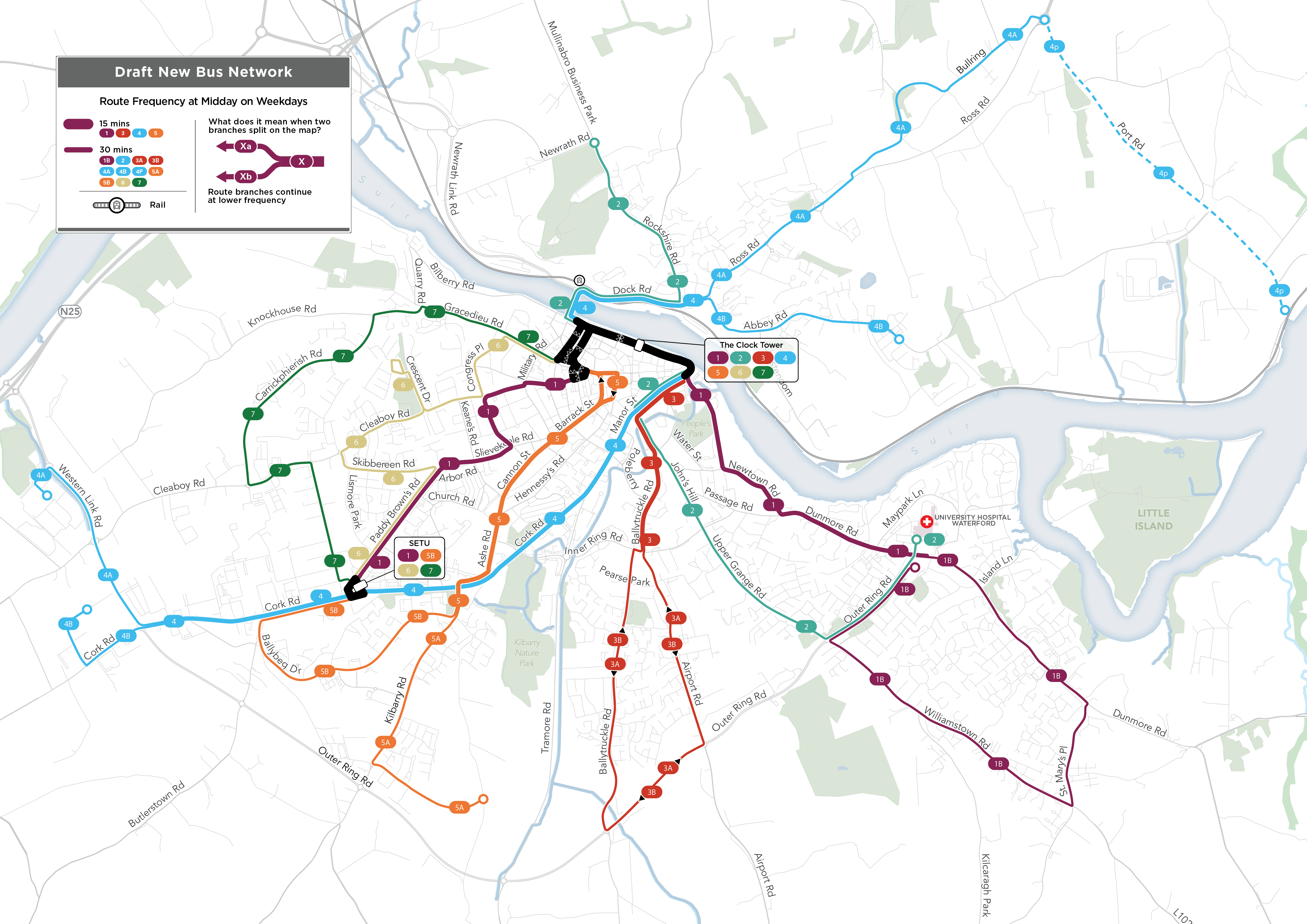
And here is the proposed network. Every route will offer two-way service. The wide lines stand for service every 15 minutes, 7-days-a-week. The narrow lines stand for service every 30 minutes, 7-days-a-week.
This design achieves several things:
- It’s radically simpler, because all routes are two way (with the exception of some short segments on one-way streets in the centre).
- It fits frequency better to demand. It offers 15-minute “turn up and go” frequency linking the biggest destinations, including the University (SETU), the city Centre, and the main hospital on the east side. Most of the really dense parts of Waterford are on these segments.
- It creates secondary focal points at the University (SETU) and hospital, offering direct service to these points from most of the areas surrounding them.
- It covers several recent new developments.
- Fewer routes end in the city centre. Instead, proposed Routes 1, 2, and 4 run through the centre and onward to the other side of the city. This reduces the need to interchange for many cross-city trips, and also makes better use of the limited space for terminating buses in the city centre.
As always, this is a draft! We know it will be improved by public feedback, which is already coming in. We look forward to the public conversation that starts now, and runs through 16 August.
Click here to explore the plan and express your view. You can find our entire report, with all of the details, here.


The original network includes a large number of interregional bus routes (in light, thin ochre) extending off the map. Are those withdrawn in the new plan, or simply not depicted on the new map?
Jacob: Good catch. They are not part of the plan, but something like them would continue to exist. NTA has a separate intercity and rural bus planning process called Connecting Ireland that covers those.
Was there any thought to attempting to create a frequent grid (or triangle), perhaps by a more direct connection between hospital at University? Perhaps by shifting route 1 from going through the inner city to taking the inner ring road?
How much of a bunfight has there been/do you expect about the 6 doubling back down Crescent Drive? This looks like something you have said never to do in your other posts.
Jonathan. NTA is aiming for complete coverage of the built-up area, which is not something that all of our more austerity-minded clients can do. Crescent Drive is a bit of really bad town planning that can only be served with a deviation. Establishing a pedestrian link between Oak Drive and Carrickphierish Road would make this deviation unnecessary and give the area access to more frequent service, but that was out of our scope. I hope that connection is built eventually.
What about the 6 “doubling back” on Skibbereen Rd to Paddy Brown’s Rd, instead of taking the direct route on Lismore Park to SETU. This adds nothing to the service on Paddy Brown’s (everyone would take the 1 which offers more direct and more frequent service) while adding time to anyone trying to reach SETU from Cleaboy, Crescent, etc. Skibbereen Rd is less than 700m long, so you would only be omitting one stop in the middle versus a stop on the 1 at the east end and a stop on a more direct 6 on the west end.
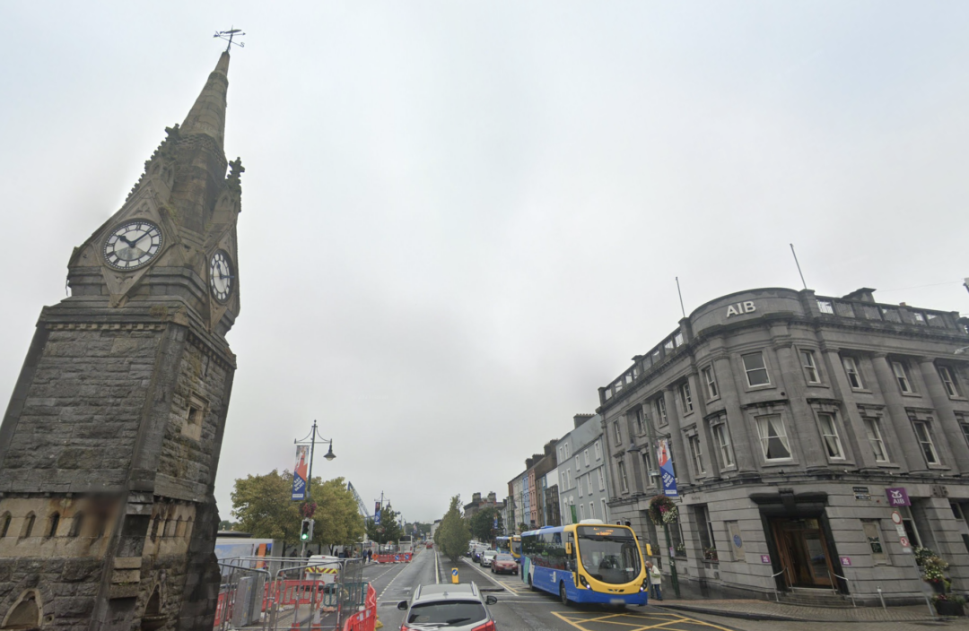
Hi Jarrett, the most important new bus route needed for Waterford is by far an orbital route (outer ring rd) from the Dunmore/Williamstown Roads via St Johns Pk to SETU, the Industrial Estate, Whitfield Hospital and SETU Sports Campus. It’s an outdated model to think all services need to serve the city centre. There are serious concerns in regard to accessing the Clock Tower with the volume of buses already serving it without adding additional services. I’d also ask that there be an upgrade to the problematic Wright fleet currently in use.
We disagree that the radial model is outdated. Orbital services require much larger markets than this one would have. We had a very similar debate in Limerick and even there we concluded that no orbital was justified. Regarding the Clock Tower, there is room for buses to drop and go. The issue is the number of buses terminating, which we have attempted to minimise by running more routes through across the city centre.
I wonder about the loop of the 1B, it seems to also be the kind of transit design you advocate against. People on Outer Ring Rd or Williamstown are faced with either a long ride the wrong way to get to downtown, or a transfer (untimed?) at the hospital. In the case of the hospital it appears the 1B doesn’t even serve it directly (like the 2) with a longish walk instead. Wouldn’t it be better to split the current 1B into a 1A on Dunmore Rd and a 1B on Outer Ring/Williamstown (still 30 min frequency but each with direct service to the hospital and city center)?
Why is there no 1A?
Also, why not through route the 3 and make the 6 and 7 the 3A and 3B respectively?
What is route 4p? The legend does not identify what dashed lines mean.
The rail station on Dock Rd should get a call out similar to the Clock tower and SETU identifying the routes serving it, connections to external transport are as key as major destinations.
Like the fact not all buses terminate in the city centre
I used to catch a articulated ,bendy, bus that had 115 people on it as it passed through Auckland CBD. Would have been a real logistic headache if it stopped and all 115 got off to get on other buses to go last 1 or 2 km.