Vancouver, Canada is a great transit city not just because it pioneered driverless rapid transit, or because of its commitment (somewhat enforced by geography) to a dense and walkable urban form. It’s also a great transit city because of great bus service planning.
Vancouver area transit agency TransLink is out with a new plan for the next 15 years of bus service growth in the densest and most transit oriented part of the region, including all of the City of Vancouver itself. They call it the Burrard Peninsula Area Transit Plan. It’s worth perusing, but here, I just want to flag one image that may be of global interest:
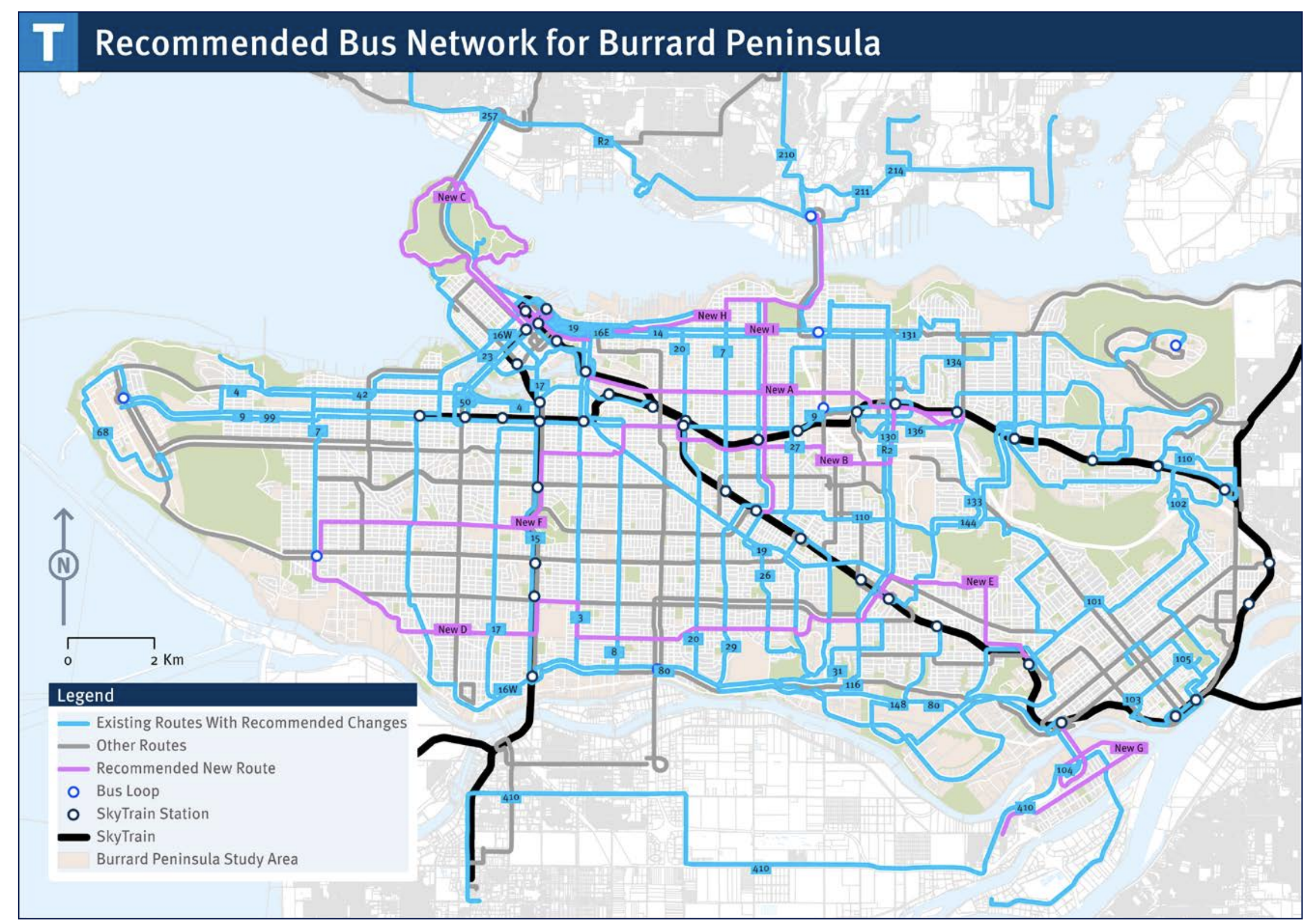
The black lines are SkyTrain, the driverless rapid transit system, including its newest extension. The grey and blue lines are existing bus routes. The purple are new bus routes they propose to add over the next 15 years.
By the time this plan is implemented, most of the blue and grey lines on this map will be frequent: every 15 minutes or better all day. Many of them already are. This map shows the current Frequent Transit Network.
Why is frequency in a grid pattern so valuable? Every time two frequent lines meet, especially at a right angle, the result is an explosion of usefulness, because each line becomes useful to get to all the points on both lines. In an ideal frequent grid network, you can go from anywhere to anywhere with a single transfer on an L-shaped path. It’s such a powerful concept that many cities whose street networks are not especially gridlike still try to achieve that effect. I discuss the example of San Francisco in Chapter 13 of my book Human Transit.
A grid works best when everyone can walk to either a north-south frequent line or an east-west frequent line. For that reason, Vancouver transit planners have always ruminated over the gaps in their grid, mostly cases where east-west lines are too far apart. The new purple lines fill ALL of these gaps. Across all of Vancouver and western Burnaby, there will finally be service both north-south and east-west near everyone.
Of course, what makes this possible is not just the grid of streets, but the rising density across so much of this area. Vancouver housing is not just the famous 40+ story towers, which are mostly clustered downtown and around rail stations, but many small apartment buildings or large homes that are being divided into smaller units. Vancouver-based experts such as Brent Toderian are promoting “gentle density” or the “missing middle”, encouraging more development of 3-7 stories or so that fits better with the historic character of neighborhoods. This transit grid helps expand the range of places where that density is livable.
Again, the regular grid pattern of arterials makes the transit grid easier, but you can get grid effects in any city of reasonable density and walkability. Just maximize the number of situations where frequent lines cross at right angles, expanding the usefulness of both lines. Then build stuff at those intersections!
Vancouver’s agency TransLink has been a big part of my career. I was an on-site consultant there for a year in 2005-6 and also for the summer of 2011, and our firm continues to work for them now and then. During my on-site time I did a lot of work on helping them formalize and strengthen the frequent transit network concept, and also build the grid. It’s great to see this idea continuing to prosper.
Your comments are very good. However, since 2020 many bad changes that reduced the overall rides per capita from 100 in 2019 to 75 in 2025.
Main reasons are by cutting frequency of service on 40 bus routes and eliminating bus routes 32 and 480.
If you really want the whole truth contact me at [email protected]
It’s bizarre that on the American continent a bus route running every 15 minutes, inside an urban area of 900,000 people, is considered “high frequency.” Over here in Europe it would be a secondary line.
Hi Marco,
In Vancouver there are several routes with articulated buses that run 90 seconds apart and on the same route as other all stops local bus every 5 minutes. These are often packed. The 99 B Line used to be North Americas highest bus ridership, maybe still is, not sure. (I have not lived there for a while now.)
This 15 minute average sounds very low frequency to my mind too. There must be a few long distance buses to the suburbs that bring the average down.
>> It’s bizarre that on the American continent a bus route running every 15 minutes, inside an urban area of 900,000 people, is considered “high frequency.”
Yes, that would be bizarre. But I don’t think anyone did that. They use the word “frequent” without the “high”. Like “spicy” instead of “very spicy”. It is a baseline level of service for many riders. It is always a judgment call, but I don’t time buses that run every fifteen minutes. In contrast, I *always* time buses that run every half hour. Thus I think the distinction makes sense. That is the focus of much of the work as well as the maps. But that doesn’t mean that there aren’t other buses that come more often. Riders definitely benefit when the bus comes every ten minutes instead. Likewise to go from ten minutes to six minutes is a huge step up. If I was making a frequency map of Vancouver (or a lot of cities) I would probably go with those ranges. So yes, I would say the “frequent service map” is a bit oversimplified for that reason. (To be fair, they do list the “Rapid Bus” lines but they don’t actually say how often they come.)
To me the impressive part is not the expected frequency (which can vary quite a bit based on the budget) but the network. I would imagine it is what Jarrett finds so appealing as well. It is pretty easy to look at the map and think “Wow, I can get just about anywhere in the city, as long as they run the buses often enough.”
In the near term there are two projects that should help the agency increase service without spending extra money. The Broadway expansion will, presumably, mean that the street needs fewer buses. It would be ideal if SkyTrain extended to UBC relatively soon (and hopefully it will). While it wouldn’t carry near as many riders, the Burnaby Gondola would also replace a lot of buses. It shouldn’t take long to build a gondola, which means that the savings could be met fairly quickly. The fastest improvement would probably be to just add right-of-way for the buses (something they are doing — https://vancouver.ca/streets-transportation/bus-network-improvements.aspx). A faster bus uses less service, which means it can run more often (or other buses can run more often).
Need to improve the grid system of bus routes .
Everyone should be within a 5 minutes walk ( 300 to 400 m ) of a bus stop
The list below provides 20 gaps( about 50 km ) in the City of Vancouver.
TransLink BPATP does not fill all the gaps
1, Arbutus St. North of Broadway( 0.6 km to 2 km )
2. Burrard St. (16th Ave. to Burrard Bridge/Downtown)( 1.7 km )
3. Clark Dr. (Venables to Hastings or Powell ( 0.6 km ))
4. Crown St. ( { Dunbar Loop } SW Marine south to MFN) ( about 2 km )
5. Nelson St. ( Stanley Park to Granville and Georgia ) (4km )
6. Victoria Dr./Wall/Renfrew to Hastings( Commercial-Broadway Station to PNE ).( about 6 km )
7 E.1st Ave/Terminal ( Main St. to Burnaby Brentwood Mall ) ( 5.7 km to 8 ) INTO BURNABY
8.. E. 12th Ave/ South Grandview Hwy .( Commercial Dr. to BCIT ) ( 3.5 km to 5.5 ) INTO BBY
9..16th Ave. ( Cambie to Fraser ) ( 1.8 km )
10.. 29th Ave. ( Nanaimo to Boundary to Burnaby Hospital ) ( 2.5 km to 3 km ) INTO BBY
11.. W. 33rd Ave. ( Cambie to Dunbar )( about 4.8 km )
12. W.57th Ave /SW Marine ( Cambie to Dunbar ) (6 km )
13 59/57/54th ( Cambie to Tyne to Champlain Hts ) ( 7 Km )
14. Redesign of bus routes in S.E. Vancouver including bus service on Boundary North of Imperial/49th ave. to Joyce-Collingwood Station ( about 2 or 3 km ) Return No. 29 service prior to 2001.
15. Mini-buses /Community shuttles could be used on many low ridership bus routes as well as On-Demand Transit where there is no need for a fixed bus route https://en.wikipedia.org/wiki/Demand-responsive_transport
16. Return two way bus service ( existed for many years ) on these streets :
a) Robson St. ( Granville to Cambie )
b) Hudson St. ( SW Marine Dr. to 70th Ave. )
17. Provide regular daytime bus service on Howe St. and Seymour St
18. Hastings St.( Renfrew to Cassiar 900 m ) Return bus service after 7 pm
19. Round The Park : Return No.52 bus service around Stanley Park
20. New Brighton Park: Return No.40 bus and/or provide new service.
It would take me a while to sort through all of the suggestions. But it is clear that you are absolutely right, just by looking at that first example. If you are traveling north on Arbutus (on the 16) it turns east on 12th, before it even reaches Broadway. It should just keep going straight and turn on Cornwall, like the 2. While this change would be justified right now, it makes even more sense when SkyTrain is extended to Arbutus. Otherwise riders at the north end of Arbutus can’t easily access SkyTrain. This change would cost next to nothing — it isn’t a new route, you just shift a route a little bit.
Oh, and that essentially solves the second problem as well. You would have a north-south bus to the east and west of Burrard. There is a pretty big gap between them but not so big I think another north-south route is justified. Maybe if the buses ran a lot more but I would rather see better headways overall. In think in general you make a good point. As good as the network is, it could be a lot better (at no additional cost).
The Burrard Peninsula Area Transit Plan fills most of the ones you’ve listed, some of which aren’t gaps (3,5,6,14,16,17,18, and 20). The 22 on Venables for instance is a deviation, as it does connect with Hastings a little further west.
The one gap that is left is Crown, but given its small catchment that would be an underperforming route if implemented.
That’s not to say that some of the deviations you’ve noted aren’t annoying (Robson in particular), but they are less critical than the actual gaps that the plan does cover.
In my opinion Vancouver has the best transit system on the West Coast. Much of it is relatively new — the first SkyTrain line opened in 1985. The key to the system is the way that the trains and buses complement each other. Yes, obviously it helps that the trains are automated and thus run often. It helps that there is a street grid that lends itself to a good transit grid. But a quick glance at the stations shows how effective this grid is. Most buses — whether they are going east-west or north-south — connect to SkyTrain. Most of the time they don’t go out of there way to do so. In other words, the metro connection is just “on the way”. When it isn’t it actually stands out, like a sore thumb. For example the Canada Line should have a couple more stations so that the buses don’t have to zig-zag. But such occurrences are relatively rare.
Unfortunately this model was not followed by Seattle. The lack of stations on the rail line make creating a grid more difficult. Even with a planned expansion (one of the largest on the planet) things won’t change very much. The bus network could certainly be better. But it doesn’t help that there are so few stations or little consideration for bus-rail integration despite the great success of Seattle’s nearest neighbor.
The Truth about the SFU-Burnaby Mountain Gondola
https://www.translink.ca/gondola
Many good questions about SFU Gondola by Joe Sulmona, a resident of Burnaby and International Transportation Consultant..
https://www.linkedin.com/in/dr-luigi-g-joe-sulmona-cfcilt-bab41215/
The Core Problem: Diseconomies of Scale and Scope
Transit economics literature is unambiguous on one foundational principle: fixed infrastructure systems deliver value through network scale and inter-linked ridership density. A single gondola line serving one destination violates both conditions simultaneously. The operational consequences are not merely theoretical. A gondola is not a bus or a SkyTrain car – it is a complex high-risk aerial lifting device governed by a separate and demanding regulatory certification regime. TransLink would be required to establish a dedicated operational unit responsible for maintaining a valid operating certificate, managing specialist maintenance personnel, and absorbing the fixed administrative overhead of an entirely new vehicle class — for a single line. None of this overhead delivers additional transit output. It instead delivers critical life-safety compliance. The Business Plan must be pressed on where, specifically, this dedicated overhead structure is accounted for, and what the per-ride cost implication is once it is fully loaded. If that accounting is absent or compressed into general operational assumptions, the Business Plan’s financial case lacks base credibility.
The Redundancy Problem: Costs That Cannot Be Avoided
Every major gondola system with a documented operational record – including the Medellin Metro Cable system, which gondola proponents frequently cite, and I recently had reason to visit – must maintain some form of parallel bus service. This is not a design choice. It is an operational requirement that flows directly from the gondola’s inherent vulnerability to closures. — TransLink will be politically obligated to maintain bus backup capacity to the Gaglardi station. The question is not whether that cost exists it does, but whether the Business Plan accounts for it fully as a permanent, budgeted operating cost rather than as a contingency reserve. If the gondola is presented as replacing bus service rather than supplementing it, that representation is operationally false, and the comparative cost analysis built on it is invalid.
The Deterministic Outage Problem: A Distinction That Changes the Analysis
Why must redundancy as noted above be treated as the norm here? This point deserves particular emphasis because it is analytically distinct from the normal reliability discussion applied to any transit mode when unplanned outages occur. ― Transit planners routinely accept stochastic failure risk, the unpredictable mechanical breakdown, the unforeseen one-off incident, etc. What transit planning must not accept, and what TransLink’s service commitments to post-secondary institutions must explicitly address, is deterministic, foreseeable service disruption. A gondola on Burnaby Mountain does not face stochastic wind risk. A gondola will face seasonally predictable, duration-estimable, wind-forced shutdowns that can be mapped on a calendar with reasonable accuracy today, and with no doubt this will occur during the Fall and Spring class sessions that are typical of high-winds in this region. And to just to name a few examples, BC Ferries operates under the same transportation operating certificate paradigm as do petroleum-bearing ships in Vancouver Harbour as well as aircraft carrying dangerous goods to and from the region’s airports. All are subject to wind-limits that are routinely invoked for a single reason public safety. The gondola would be no different, if implemented. The operating certificate that TransLink must obtain will contain mandatory wind shutdown thresholds. The majority of the Burnaby Mountain route runs north-south, placing it directly in cross-angle exposure to the dominant high-wind patterns and within the precise periods when SFU’s academic calendar places maximum demand on the corridor. ― This is not a risk to be managed. It is a fundamental design characteristic of the vehicle and carrying system that will operate in this specific geography. TransLink will know, in advance, that it will be fielding emergency bus capacity during these periods in each core semester period. That cost and the service disruption are both certain; all that is uncertain are the precise dates. The Business Plan should model this explicitly. If it does not, it is not a business planning document – it is a promotional brochure. ― Granted, gondola proponents may argue that premium multi-cable systems tolerate significantly higher winds than a standard configuration; this is correct, but the literature also suggests at roughly double the cost. But operational continuity in the face of extreme conditions and a rider’s willingness to tolerate such a rough ride are not the same thing. Accordingly, has TransLink surveyed existing users to establish whether a system that remains technically running through a 90 km/h crosswind is one that passengers may be willing to board? We all regularly experience the Lower Mainland’s Fall and Spring wind events that reach this threshold range, which are even more pronounced at the exposed elevated terrain with the peak of Burnaby Mountain. These are not unexpected anomalies, any ridership and revenue projection that does not explicitly model passenger avoidance during these events is not a business plan; it is a hope-for-the-best scenario. ―
The Personal Security Problem: A Consequence of Low-Density Operations
Crime Prevention Through Environmental Design (CPTED) principles, well-established in transit safety, identify low-occupancy, single-entry/exit vehicles as high-risk environments. An off-peak gondola cabin carrying a few passengers presents exactly this public safety profile. Unlike SkyTrain, where network-wide ridership ensures meaningful occupancy at most hours, a gondola serving a remote campus will have peak and trough ridership. The CPTED response is limited: (1) accept the security exposure, (2) restrict off-peak service, or (3) deploy attendants. Material consequences arise for the Business Plan that will impact cost efficiency, undermine service reliability, or create new operating costs. No responsible TransLink board can accept Option 1, and Options 2 & 3 destroy pillars of the proposal’s financial case. The Business Plan must address this trilemma directly, with costed and risk-tolerance options for a board-level political decision A plan that lacks this kind of public-safety assessment is just a fable.
Gondola Emergency Response: Cost to Burnaby Taxpayers
A gondola strung above the forests covering Burnaby Mountain is not TransLink’s emergency response problem – it will belong to the City of Burnaby. When the line stalls mid-span, with potentially hundreds of riders in cabins stuck many meters above the ground, Burnaby’s highly respected Community Safety Services will invariably respond – with specialized high-angle aerial rescue equipment and personnel certification that the city may not currently carry at the scale this type of new infrastructure would demand. The logic is straightforward: TransLink builds and operates the gondola; Burnaby taxpayers fund the equipment, the training programs, and the liability exposure indefinitely, for infrastructure that no other community in the region will be accountable for in a similar way. The Business Plan must account for this emergency response cost transfer explicitly, and the City of Burnaby has every right to demand that it does.
The Medellin Comparison: What the Evidence Actually Shows :
The Medellin Metro Cable system is frequently invoked in support of gondola transit. It deserves a precise reading. Medellin’s gondolas succeed because they satisfy three core transit economic conditions simultaneously: they connect high-density residential hillside communities to a high-frequency metro network at valley floor; the topography makes robust surface alternatives impractical; and the system operates as part of an integrated multi-line network that distributes administrative overhead at a serious scale. These conditions do not apply here. SFU does not sit above a high-density residential that could have multiple stations for combined community access. The route has an improvable bus corridor. And TransLink would not be operating a network – so that overhead can be distributed across additional routes to achieve the unit-cost efficiencies that make Medellin work. The North Shore and Upper Coquitlam represent the only topography in the region that could create a potential gondola case, and both lack the residential density to satisfy the ridership opportunity conditions. The appropriate conclusion from the Medellin comparison is the opposite of what proponents may claim: Medellin demonstrates precisely what conditions must exist for gondola transit to be justified — and Burnaby Mountain does not meet any of them.
The Alternative: Scale, Flexibility, and the Core Transit Proposition ―
It is plainly evident that the correct intervention for the Burnaby Mountain corridor is re- investment in the existing bus network’s operational performance. This means higher-power fleet specification, dedicated snow-clearing capacity an investment that has already demonstrated itself to be practical elsewhere with a dedicated tow truck program – and serious examination of corridor infrastructure such as bus priority lanes or targeted infrastructure improvements to address the Gaglardi Way/University Drive intersection. These interventions retain the fundamental advantage that all sound transit investment should preserve: scalability. Bus capacity can be added incrementally as demand grows. Routes can be adjusted as development patterns change. Fleet investment produces assets that are deployable across the network, not stranded on a single fixed line. This is not a conservative argument against investment – it is an argument for investment that compounds rather than isolates into a narrow operational practice.
Gondola Procurement: Exports Public Transit Dollars
Every dollar committed to a Burnaby Mountain gondola flows directly to a foreign-owned multinational with no significant Canadian manufacturing base. The alternative – electric buses purpose-built for steep-grade and winter conditions – draws on a domestic supply chain that already exists and is ready to deliver: Canadian bus manufacturers and Canadian electrical systems integrators who build and service zero-emission transit vehicles. Electrification of this corridor also aligns directly with federal transit funding priorities that have explicitly identified electric bus fleet renewal as an eligible investment category, making federal co-investment available. Public capital should build Canadian industrial capacity, not export it.
Conclusion
The SFU Gondola proposal is, on current evidence, a solution in search of a problem. The problem it purports to solve unreliable, slow service to Burnaby Mountain — is real. The solution it proposes does not survive contact with transit economics, operational planning requirements, or an honest reading of the principal international comparators it relies upon. Respectfully, TransLink must test the gondola’s Business Plan against the specific questions raised here before any public commitment of resources is made. Regional transit users and taxpayers are entitled to that analysis, and a fair reading of the long-term consequences of investing public funds in this limited way. I offer this assessment to support the important work of those who want to see the Burnaby Mountain transit corridor improved in a way that the regional transit system can sustain. Respectfully submitted, Dr. Luigi G. (Joe) Sulmona, CFCILT https://ciltinternational.org/about-cilt/
Beautiful article, Thank you!
GTU
GTU