Author Archive | Jarrett

“Give Mrs. McG Her Bus Stop”? Reasons to Pause

Here’s some refreshing candor from a local politician, in the context of an effort to speed up express bus services on New York’s Staten Island by removing excessive bus stops and deviations:

Borough President James Oddo added that “people like me” were part of the problem: Requesting new bus stops to help vocal constituents.

“Who doesn’t want to give Mrs. McGillicuddy a bus stop?” Oddo asked.

When bus routes meander, do little squiggles, or make too many stops, the cause is almost always local elected officials who insisted that transit agencies say yes to whatever a noisy constituent demands.  Such officials are always calling the transit managers and saying: “Get Mrs McGillucuddy off my back!”

Of course, Mrs. McGillicuddy rarely calls to advocate the kinds of efficiency that makes transit more attractive and useful for the whole community.  She’s calling to demand something that’s good for her or her friends.

Here, as often, we’re in the presence of the paradox of public outreach.  We want transit to be useful to busy people, but busy people don’t engage much with public outreach processes.  They’re too busy.

So we disproportionately hear from the not-busy people, who have priorities other than speed.  So we hear demands like:  “All those busy people should have 3 minutes added to their trip so that I don’t have to walk three blocks.”

I don’t want to dismiss the concerns of senior and disabled riders, but if a person physically can’t walk three blocks, then the answer may be some kind of paratransit.  Paratransit is expensive, but not as expensive as doing something every hour all day to meet just one person’s needs.  There are some genuinely difficult choices here, but they should be addressed by a policy, rather than a process of just rewarding whoever makes the most noise.

Because if a transit agency establishes a pattern of saying yes to every demand for things that slow down the service, that precedent will only trigger more demands, accelerating a downward spiral in which a resource designed to be used by many becomes micro-designed around the demands of one or two, to everyone else’s detriment.

Arguing against these demands with data is tricky.  The differential impact of adding one bus stop or squiggle may not be much. It’s the cumulative effect of 100 such decisions is devastating, gradually transforming relatively fast and efficient services into slow, meandering scenic tours that only people with lots of spare time to use.

So you really need policy, not just data, to hold the line.  Service design standards about stop spacing and linearity can give staff the backup they need.  These standards should be periodically re-adopted, so that current elected officials feel ownership of them, or at least understand the dangers of not observing them.  And the adoption is the time to have the debate about how to balance some people’s difficulty walking with the need for transit to be fast, direct, and reliable.  Again, the point is not to leave seniors behind but to ensure we’re addressing their needs in a fair and consistent way.

Dublin: Imagine a Better Bus Network Design

buses1

Today, the National Transport Authority of Ireland launched the planning process that will lead to a redesign of the bus network in Dublin. We are incredibly honored and excited to be their lead consultant on this effort.  I explain the planning issues (for a Dublin audience) here.

Our project is part of BusConnects, which is a three-pronged effort to improve Dublin’s buses:

Dublin has less rail transit than most European cities of its size. There is no subway, two surface light rail lines, and one corridor along the coast where commuter rail runs every 15 minutes. So most of the city is on buses, and the buses must succeed for the city to succeed.

The bus service is abundant; almost 1000 buses are on the streets during the peak period, in an urban area of 1.2 million. But as is the case in almost all growing cities, the service may need revision to reflect some emerging needs. These include:

First, all frequent lines run into the City Centre, so trips between suburbs out can be difficult.  Orbital routes exist but they are not frequent enough for the connections on which most orbital travel relies. This becomes a bigger issue as suburban employment centers – some of them well suited to public transport – emerge.

Second, the system is very complex. We drew what may be the first really clear map (link coming soon) of the entire network, but we put a grey box over the City Centre, where a clear map may be literally impossible. Here is the best version available.  You see the problem.

ComplexCityCentre

As a result, we think Dublin may be missing opportunities to encourage patronage within the greater City Centre – especially for spontaneous trips and tourism — because while buses are everywhere, it is simply too hard to figure out how to use them. As consultants we can attest to this, because our work requires learning bus systems very quickly.

Finally, the City Centre has so many buses running through it that buses are frequently obstructing each other.

buses2

This problem has many solutions, including bus priority and ticketing improvements that parallel tracks are addressing. But we might be able to reduce these numbers a bit, especially with better orbital service that reduces the need to go through the city if you are not going there.

But as it turns out, the key to all of these problems is one question: Can we ask people to change buses if this means they can reach their destinations sooner, and reach other destinations citywide more quickly?  (I explained that math here.)  This is a hard question, because whatever we do to make it easier, changing buses is still an inconvenience.

So we’re asking the public what they think.  For the next month, we’ll be accepting input through a web survey, which you can find here, along with our Choices Report that you can download.  There, we share some specific possibilities, and ask the people of Dublin about their priorities.  As usual we ask:  Given how the math works, and the choices it presents, what should we do?


Notes on the Portland Terror Attack

Portland — where I grew up, and where I live again now — isn’t used to being attacked, but I’m proud of how many there are responding.  The terror attack on our light rail system, in which two men were killed and another injured for trying to stop the abuse of Muslim passengers, has been understood as an attack on the city itself.

If citizens cannot accommodate the ways they are different from one another, a democratic city is impossible.  Diversity — and the principle of kindness toward people who are different from you — is as essential to our city’s functioning as a water supply is.  So attacks on diversity are as much of a threat as attacks on our water supply.

Public transit, in particular, is always under attack, in part because of the levels of mutual respect that it requires.  No moment in urban life requires such intimate contact with diversity as the time spent on transit.  You are closer than you might like to people who are different from you, and unlike on the street, you can’t just walk away.  Sharing space on a bus or train requires 100 little adjustments, tiny acts of respect or accommodation.  Not everyone can do this.  So for those trained to read diversity as danger, hatred of public transit is understandable.

The healthiest response to this kind of attack, I think, is to take it personally, as most Portlanders I know are doing.  We should understand that the hatred is directed at each of us.  This is moral outrage that resonates through at least three tiers of concern:  It’s an attack on our own values as individuals, and also on our city, and also on the whole idea of civilization.  Feel how similar those three ways of being offended really are.

Then respond with an outrage that remains fused with kindness for one another.  For that is the whole point.

The Receding Fantasy of Affordable Urban Transit “To Your Door”

Uber’s UberPool service, which attempts to gather multiple people on a single vehicle going the same way, is undergoing some tinkering that will make it even more like fixed route transit.  Andrew J. Hawkins at Verge has the story:

[UberPool riders] are being prompted to walk to the closest corner or intersection for more convenient pickups, rather than have drivers deviate from their north-south route.

The same goes for drop-offs, where riders are being let out at a proximate corner rather than the exact address of their destination. Uber calls it “dynamic drop-offs,” but the result is pretty plain. If you want those cheaper fares, you’re going to have to be cool with a lot more walking. Uber began testing this feature last year, and has since rolled it out in wider use.

Does the difference between these images remind you of anything?

Walking further for more direct, useful, and affordable service is the basic deal that fixed route transit has offered for more than a century.

What’s more, if you walk to the bus instead of to UberPool, you can get on any bus instead of waiting for your specific UberPool to arrive.

Yet this is exactly what Uber must do to make their UberPool less unprofitable.   As we’ve explored many times here, demand-responsive service is wildly inefficient.

UberPool would be less absurd if we were talking about somewhere other than Manhattan, or any other big city that’s rich in frequent transit.  In places with less transit, this concept could have some use.  But in big cities it’s clearly converging on something for which fixed route transit is already the ideal tool.

Now, New York City bus service has some problems, especially in the delay-ridden way that they handle fares.  I am not defending specific practices of any agency.  But the geometry remains what it is.  If you want affordable transit service, you’re going to have to walk to it.  That’s the math that makes fixed route service inevitable.

Transit people all over the world have understood this since long before Uber’s CEO was born.  They’ve also known about the concept of demand responsive transit, which means “transit that is extremely inefficient because of the degree to which it deviates or circulates based on the needs of a single person.”  Demand responsive service is so inefficient that it arises only in these contexts:

  • extremely low-wage environments, as in parts of the developing world, or:
  • focused on elites who can pay high fares, as in typical Uber or Taxi operations, or
  • for special-needs groups, such as the disabled and seniors, or for other groups that have the power to demand it, always at astronomical subsidies per rider.   (Costs per rider for this kind of service, called paratransit in North America, typically run about 10 times the rate for well-designed fixed route service.)

All the new apps have helped smooth out inefficiencies of communication, but they will never change the math.  Technology never changes geometry.

As UberPool gradually discovers this, the question becomes: Did Uber, and similar companies, really invent anything at all?  They invented apps, and algorithms, but do they have any new answers for the geometry problem that is urban transportation?


(Yes, I said almost exactly this in a post two years ago!  But one needs repetition to break through all the noise)  


The Pleasure of Track Maps

If you’ve never seen a subway track map, I suggest you look at this one, for New York, by “radical cartographer” Andrew Lynch. Most track diagrams are not to scale, and look like they’re meant to make to make sense only to insiders.  But this one is beautiful.
nyc track map b


What’s more, it’s accurate in geographic scale, though of course the separation of tracks can’t be on the same scale as the network.  Still, New York’s subway is both huge and full of details, so this is no mean feat.  Only 22 insets were required, to zoom in on tricky segments.

Gazing at a good track map can give you an appreciation for the heroics involved in moving trains around in this limited infrastructure. Switches and extra tracks are very expensive underground, which is why they are never where you need them to handle a particular incident.  This, for example, is why a track closure at one station may continue through several stations nearby.

Gaze at this piece of the Bronx, and marvel at what a train would have to do to get from Jerome Yard to a station on the Orange (B+D) line.  I presume they don’t have to do this very often, but in a pinch, they can.

nyc track map a

I spent a delighted hour with it.

Toronto: Defending Transit’s Right to Move

Toronto’s King and Queen Streets — where packed streetcars stop and wait behind one left-turning driver or someone taking forever to parallel-park — is one of North America’s greatest monuments to the natural superiority of motorists over everyone else.

100+ people's lives held hostage by the lady in the grey car at far left. Photo: GTD Aquitaine at Wikimedia Commons

100+ people’s lives inadvertently held hostage by the lady in the grey car at far left. Photo: GTD Aquitaine at Wikimedia Commons

These streetcars are all Toronto has in the way of east-west transit through the very core of downtown, yet their operations are routinely strangled by quite small numbers of cars, running as slow as 6 km/hr (4 mi/hr) (!) during the peak in the most critical section. This for a service that carries the overwhelming majority of the people moving down the street.

We’re talking about the middle of downtown Toronto, the city’s densest and fastest densifying area.  For such a place to function, transit just as to succeed.

We're clear on how dense downtown Toronto is, right?

We’re clear on how dense downtown Toronto is, right?  The King streetcar connects this area to very dense residential areas to the east and west.

Since this is Canada, you can be sure these are legacy streetcar lines.  Almost nobody outside the US intentionally builds streetcars in mixed traffic, but many cities have inherited them.  Long ago, they were reliable because there wasn’t much traffic.  But things got worse in the usual boiling-frog manner, and now here we are.

Now, the city is attempting the first step to improve things, by banning through traffic on King Street, one of the two key arteries.  Oliver Moore has the story, which sounds like almost every story about a city trying to pry a little space away from the motorist so that anyone else can move.  In few places, though, are the motorist’s claims to dominion so indefensible.

The key change will be that cars will be forced right at every intersection, and left turns will be banned.  There are still compromises: traffic is still in the streetcar’s lane, and refuges for passengers to board and alight will be marked only with paint.

Yet the plan will still be controversial at Council, with some Councilors arguing that they have a geometrically incoherent “right” or “need” to drive cars anywhere in the city.  This plan is a critical step, and deserves enthusiastic support.

World’s Best Non-Institutional, Self-Funded Blog! How Nice …

best blog medalFeedspot has identified us as one of the world’s 100 best transit blogs, but more remarkably, we’re at #4 out of these 100, after the World Bank’s blog and two big industry new blogs, Mass Transit and METRO Magazines.  That means we can call ourselves the world’s best blog that’s not part of a big institution or journalistic enterprise, and that’s totally self-funded without advertising.  Yes, this blog is lightly associated with my (little) firm, but I still do almost all the writing, and it’s still largely my personal work.

There are lots of awards out there, but this feels like a real evaluation, based on a mixture of editorial quality and influence.

So, cool!  Thanks!  This is nice gesture!

Burlington: A Transit Plan for a Toronto-Area City

By Scudder Wagg.  (Scudder is our firm’s new East Coast lead, based in Richmond, Virginia.)

One of the more exciting developments in the Greater Toronto Area is the conversion of historically infrequent commuter rail lines into all-day frequent services, so that you can travel, and make connections, at all times of day. This is creating new rewards for suburban cities who develop more frequent local bus networks. When local bus trips connect to a regional train with minimal waiting, they become useful for vastly more destinations and therefore will attract more riders.

Burlington Waterfront. Photo: László Varga

Burlington Waterfront. Photo: László Varga

We are now getting started working with the City of Burlington, in the western suburbs of Toronto, to help them rethink their transit system. The city has been shifting its focus in recent years from a suburban growth pattern to a city that wants to grow up instead of out. Combined with the region’s plans to improve the commuter rail line serving the city to 15-minute service all day, there is a fertile opportunity to rethink the role transit can play in Burlington.

As part of the Greater Toronto-Hamilton Area, Burlington is growing fast but the style of that growth is shifting. For many years, the city sprawled northward from Lake Ontario in a typical suburban pattern. But in 2005, the provincial government instituted a greenbelt, putting a limit on the sprawl. Having hit the greenbelt limit, Burlington has responded by intentionally deciding to grow more intensely.

With so much sprawling growth over the last twenty years, the transit system has been stretched to try to cover as much of the newly developed area as possible. This has shifted the transit system toward a higher coverage focus. The city’s transit system has only a few routes with anything approaching high frequency.

But the city has a strong two-kilometer grid built around the old concession roads that could form the backbone of a grid transit network, although the spacing of parallel grid streets is too far for this to be the only service.

The City adopted a new strategic plan in April 2016 that calls for shifting more trips to walking, biking and transit. They are following this up with a new Official Plan, currently in the draft form, that calls for higher density development in key areas. The draft Official Plan also promotes expanded and improved transit system with a frequent transit network to connect key areas.

We are helping to translate these visions and goals into a concrete network that can be implemented by 2019. That network can then be expanded and improved over time as the city adds more hubs of density and more walkable areas. We look forward to lots of great conversations about transit in this fast-changing and growing city over the next nine months.


The Virtues of Impossibility

Jane McGonigal — the noted game designer and futurist — has a TEDx video about imagining the future.  I’ll be speaking at this topic at CNU on May 4, so having loved her book on gaming, Reality is Broken, I was curious about her take.

You can watch it here, or below, but I also summarize it below.

McGonigal’s project here is to undermine that pervasive feeling that we are unable to shape the future.  “The future is dark,” she says, not in the sense of bad but in the sense of hard to see into.  It is precisely our ignorance of the future that gives us the space to imagine it, and thus to change it.

She tells the story of a futurism class she teaches at Stanford, where she asks students to name things that they are absolutely sure will be true in ten years.  Then, she takes this list to researchers and asks how sure they are of those things.  Sure enough, there are cases where something that people thought was permanent is in fact changing.

I am totally with McGonigal on the urgency of helping people imagine a more diverse range of futures, but we must also notice how easily this message gets out of control, and how much of the craziness — and destructiveness — of the tech industry arises from this belief in the radically open future.

If I were in her futurism class I could easily name things that will absolutely be true 10 years from now.

  • The circumference of a circle divided by the diameter of the circle will still be a little over three.
  • Adult elephants still will not fit into wine-glasses.
  • There will still be a mathematical limit to how many vehicles — each filling the width of a traffic lane — can fit down a single lane in a state of free flow.
  • In the absence of barriers to walking, the density of population will still determine the number of people within a fixed, short walking distance of any point.  That in turn determine the potential market size for fixed transit, which will govern the level of transit intensity and infrastructure that will pencil out in ridership terms.
  • Carrying fewer people in more vehicles will consume more urban space, compared to carrying more people in fewer vehicles.  This mismatch between demand for road space and its supply will manifest as either traffic congestion or a need to widen roads, removing scarce urban land from other uses.

Those are geometric facts.  Within the scale of space and time in which humans live, no invention can change these things.

McGonigal’s rhetoric echoes that of the corporate motivation industry, with its endless implication that nothing is impossible.  But as with heated political rhetoric, the danger is always that some people take this stuff literally, and literally, it’s nonsense.  The facts about the future I listed above are extremely useful, despite not being ridiculous.  They are useful because they keep us from imagining, and spending billions on, truly impossible things.

If we know one thing from watching the tech industry, it’s that the wide-open “anything can happen” futurism that McGonigal praises can be its own bubble, with its own blinders.  Much good has happened from Silicon Valley’s willingness to throw venture capital at the occasional wild idea — “moonshots,” they’re called in the biz — but a lot of VC also goes to investing in mathematically impossible things — like moving people from big transit vehicles into small ones without taking up more space — and into attacking folks like me who try to point that out.

In this new era of “disruption,’ urban transportation suffers as much from delusional imagination as from lack of imagination.  Only when we allow boring math to constrain our imaginings — and when venture capital gets smarter at recognizing those constraints — can we start to have reality-based conversations about how to liberate people to move in our cities.

Not everything is possible, and it’s a good thing, too.


San Jose / Silicon Valley: A New Bus Network

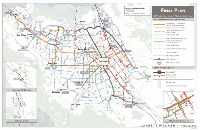
We’re now at the end of a 1.5-year study to help Silicon Valley’s local transit agency, VTA, rethink its bus network.   I explained the thinking, and public conversation, that led to the draft final plan in this comprehensive post, and also showed how it compares to the existing one.  The final plan looks pretty much like the draft one with a few additions and adjustments.

Here’s the new network.  Download a sharper copy here.

VTA Final Plan

The plan is expected to be implemented when the BART extension into the area opens next year.

You can explore the plan in more detail here, including maps, route-level info, and the background documents in the Board report.

We’re very proud of this work, and of all the people — in the transit agency, other local governments, and the broader community — who worked with us design and refine it.  With this plan, 150,000 more people will have access to all-day high-frequency service, as will 160,000 more jobs.  A huge expansion in weekend service is planned.  A new rapid bus line is added.  (Again, more on the details here.)

Most importantly, more people can get to more places sooner, so that they can do more things and have better lives.  And that’s what we’re all about.