Tag Archives | coverage

Cleveland: Tell us what you think about these alternative networks!

Our work on Greater Cleveland’s transit network is now available online, and we’re looking for people from the area to provide their input through this online survey.  The transit agency, GCRTA, hired us this year to help develop transit network alternatives that would illustrate what the transit network could look like if it shifted its focus more towards attracting higher ridership, and what it what the network would look like if it shifted towards extending coverage, as well as what the possibilities may be with different levels of funding.

The local newspaper, the Plain Dealer, has a great article about the networks and what they are intended to illustrate.

Cleveland is fortunate to have a relatively dense, and walkable pre-war era development pattern across much of the city, but as with most places in the United States, the trend over the past half-century has been the continual spread of residents and jobs to far-flung locations across the region. Since the region as a whole is growing very slowly, or not at all, this slow dispersal of the tax base poses a long-term challenge for the stability of transit resources and travel markets as more people and jobs flee to the margins of Cuyahoga County, or beyond.

When operating resources are limited, as in GCRTA’s case, the ridership/coverage tradeoff is put front and center in any discussion of what transit can do. Today’s network extends to most, but not all, of the developed area of the county, and provides little high-frequency service within the dense, walkable core of the region. Reaching more of Cuyahoga County would mean curtailing frequency in dense areas even more. But building a robust frequent network would require pulling back from many of these lower-density suburban areas, as there is little waste or duplication to reallocate in the current service design of RTA’s network.

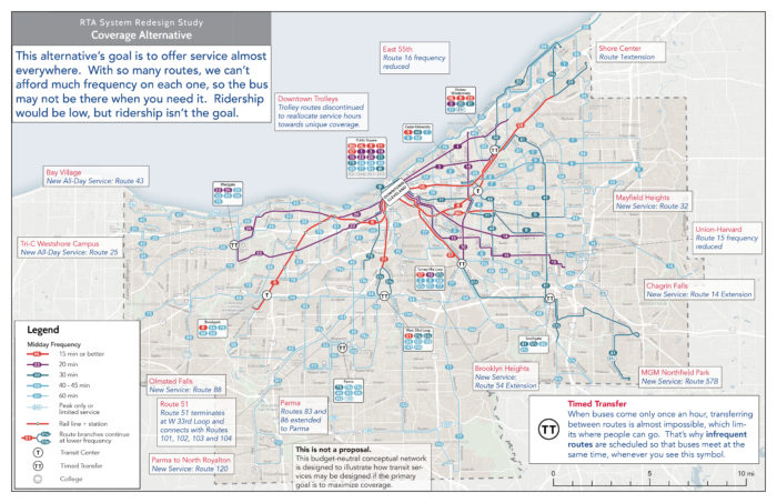
In this context, RTA has brought us in to help explore what the transit network could look like today, if different policy priorities were emphasized more strongly in network design. Further on in the project, we’ll also be developing alternatives for different financial scenarios. Right now, RTA is conducting outreach on two alternatives: a High Frequency Alternative which brings frequent service to most of the dense, walkable central areas of Cleveland and the inner-ring suburbs, and a Coverage Alternative, which spreads low-frequency service to more of county.

The purpose of these alternatives is to illustrate for the public, stakeholders, and the agency’s Board of Trustees the potential outcomes of a policy choice to focus more on ridership or on coverage. (You can click each map below to explore a larger annotated version).
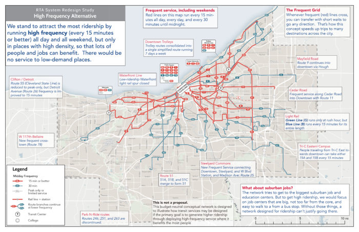
The High Frequency Alternative concentrates service so that lines run more frequently, reducing waiting times and making travel by transit more convenient. The network would reach fewer places, but where it does reach, trips would be faster than with the Existing Network.

As a result, over 40% more jobs would be accessible by the average county resident in an hour with the High Frequency Alternative. But on the other hand, the reduction in overall network extent reduces the number of people within a ½-mile walk to transit by over 20% from current levels.

You can compare the structure of the network on Cleveland’s east side to see this principle in action:
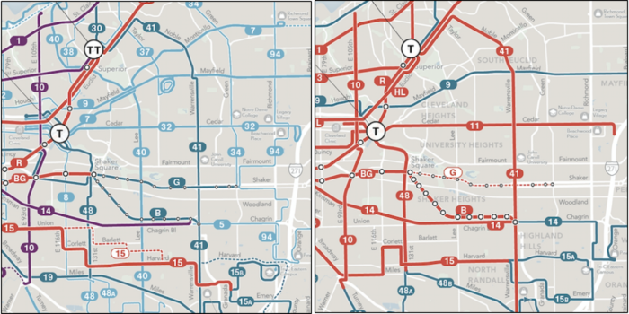
GCRTA Existing Network (left) compared with the High Frequency Alternative (right)

On the other hand, the Coverage Alternative spreads out service across the county, but spreading it out means spreading it thin. Frequencies would be lower throughout the network. This means that the network reaches more places but some trips would take much longer. Because these are budget-neutral alternatives, expanding the reach of the network requires reducing service levels on other routes, some routes that run every 45 minutes today would run every 60 minutes, and RTA’s single existing 15-minute bus service would run every 20 minutes. About 25,000 more people would be within a ½-mile walk of a transit stop, about a 5% increase from the Existing Network.

We hope these alternatives clearly illustrate the ridership/coverage tradeoff as it applies to Cuyahoga County and Cleveland. If you live in the area, please tell us what you think! You can learn more about the project and alternatives here.  Then, if you live, work or study in Cuyahoga County, be sure  take this short online survey.


Basics: The Ridership – Coverage Tradeoff

Is your transit agency succeeding?  It depends on what it’s trying to do, and most transit agencies haven’t been given clear direction about what they should be trying to do.

This post revisits a basic topic at the core of transit planning decisions that everyone engaged in conversation about transit should understand.

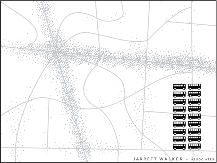
In the fictional town below, the little dots indicate dwellings, jobs, and other destinations. The lines indicate roads. Most of the activity in the town is concentrated around a few roads, as in most towns.

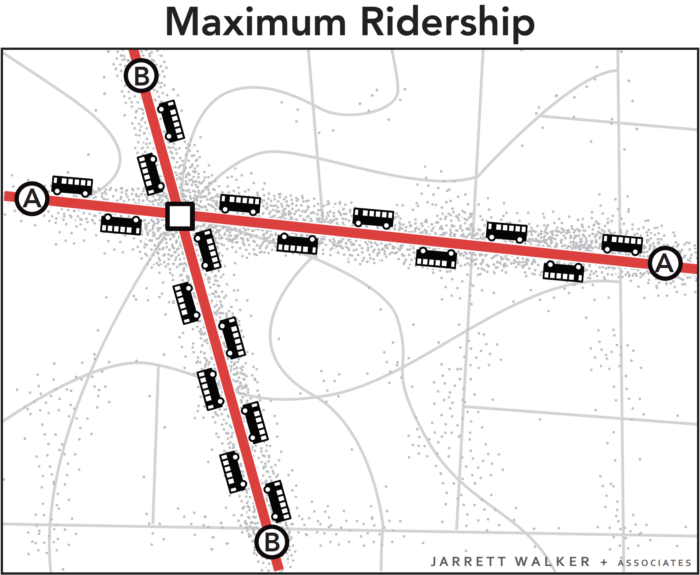
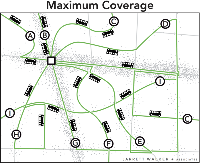
Imagine you are the transit planner for this fictional town. The dots scattered around the map are people and jobs. The 18 buses are the resources the town has to run transit. Before you can plan transit routes you must first decide: What is the purpose of your transit system?

Designing for Ridership

A transit agency pursuing only a ridership goal would focus service on the streets where there are large numbers of people, where walking to transit stops is easy, and where the straight routes feel direct and fast to customers. Because service is concentrated into fewer routes, frequency is high and a bus is always coming soon.

This would result in a network like the one below.

All 18 buses are focused on the busiest areas. Waits for service are short but walks to service are longer for people in less populated areas. Frequency and ridership are high, but some places have no service.

Why is this the maximum ridership alternative?  It has to do with the non-linear payoff of both high density and high frequency, as we explain more fully here.

Designing for Coverage

A network designed for ridership would not go to many parts of the city.  In the map above, someone who lived in the southeast part of town would not like this network at all.  That person is likely to want a network designed for coverage, not ridership.

In a network designed for coverage, the transit agency would spread out services so that there would be a bus stop near everyone. Spreading it out sounds great, but it also means spreading it thin.  The resources would be divided among so many routes that it wouldn’t be possible to offer much service on any of them.  As a result, all routes would be infrequent, even those on the main roads.  Infrequent service isn’t very useful, so not many people would ride.

The 18 buses are spread around so that there is a route on every street. Everyone lives near a stop, but every route is infrequent, so waits for service are long. Only a few people can bear to wait so long, so ridership is low.

In these two scenarios, the town is using the same number of buses. These two networks cost the same amount to operate, but they deliver very different outcomes.

Both Goals are Important

Ridership-oriented networks serve several popular goals for transit, including:

  • Reducing environmental impact through lower Vehicle Miles Travelled.
  • Achieving low public subsidy per rider, through serving the more riders with the same resources, and through fares collected from more passengers.
  • Allowing continued urban development, even at higher densities, without being constrained by traffic congestion.
  • Reducing the cost of for cities to build and maintain road and bridges by replacing automobile trips with transit trips, and by enabling car-free living for some people living near dense, walkable transit corridors

On the other hand, coverage-oriented networks serve a different set of goals, including:

  • Ensuring that everyone has access to some transit service, no matter where they live.
  • Providing lifeline access to critical services for those who cannot drive.
  • Providing access for people with severe needs.
  • Providing a sense of political equity, by providing service to every municipality or electoral district.

Ridership and coverage goals are both laudable, but they lead us in opposite directions. Within a fixed budget, if a transit agency wants to do more of one, it must do less of the other.

Because of that, cities and transit agencies that lack adequate resources need to make a clear choice regarding the Ridership-Coverage tradeoff.   In fact, we encourage cities to develop consensus on a Service Allocation Policy, which takes the form of a percentage split of resources between the different goals.  For example, an agency might decide to allocate 60 percent of its service towards the Ridership Goal and 40 percent towards the Coverage Goal.  Our firm has helped many transit agencies think through this question.

What about your city?  How do you think your city should balance the goals of ridership and coverage?   There is no technical answer.  Your answer will depend on your values.

Further Reading

Jarrett Walker’s Journal of Transport Geography Paper, which first introduced this concept, is here.