As the public consultation on the Dublin bus network redesign ramps up, we’ve been working hard to get information out in as many ways as possible.
Today, at busconnects.ie, you’ll find an interactive map that shows you two things:
- Where Can I Go? Click a location, and the tool shows you how the plan changes were you can get to, in 30, 45, or 60 minutes midday, including the average waiting time at the start of your trip. It also shows you the change in the number of jobs or school enrolments that you can get to in that time.
- Show Routes. This gives you an interactive layer showing all the proposed new routes, with the most frequent routes shown most prominently. This is a good tool for exploring the new network, and seeing how you could make various trips within it.
Where Could I Go?
Click “Get Started” and then click any point on the map. Let’s select Priorswood in Dublin’s north east. Then, in the upper left, you can choose whether you want to see what’s reachable in 30 minutes, 45 minutes, or 60 minutes. Let’s choose 60 min.
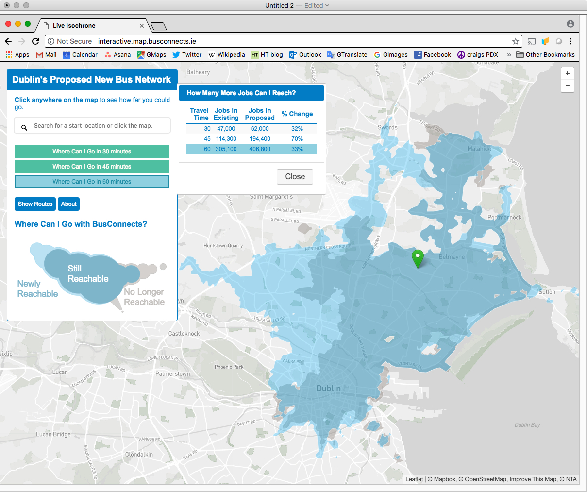
See the legend at left.
- Dark blue is the area that you can still reach in that time. (You can reach it now, and in the new network you still can.)
- Dark grey is the area that you can no longer reach in that time. You can see a little of this on the east edge of the city centre, and around Malahide in the north. (Yes, I know this looks too much like the light grey of the parks and bay, but if you look close you’ll notice the difference. There are good but boring technical reasons[1] why we didn’t have a free hand in choosing colours.)
- Light blue is the area that you can newly reach under the new network. You can’t get to these places in 60 minutes now, but under the proposed network, you can.
- The box “How Many Jobs Can I Reach?” shows you that the light blue area, minus the dark grey area, amounts to an increase in 1/3 in the number of jobs (and student enrolments) that you can get to in an hour. We show these because there’s good data on where they are, but obviously this gives you a sense of your ability to get to all kinds of useful things: shopping, social opportunities, etc etc.
Want to dig deeper into these calculations? See Chapter 8 of our full report.
Across all of Dublin, the average person can go 20% farther (i.e. to 20% more jobs and student enrolments, and thus other useful places) in 30 minutes. But this tool shows you what that result is for any location, and where.
Many people have asked us for “travel time maps”. That’s what this tool is. Compare the 30, 45, and 60 minute results, and you’ll get a good sense of how long it will take to get somewhere, and whether that changes.
And yes, this is the midday outcome, which is usually also the outcome for the early evening and weekend. Doing this calculation for the peak rush hour raises several difficulties [2]. The outcome will usually be the same in direction (positive or negative in the jobs reachable), though sometimes not as dramatic in the degree of change. For outer suburban areas, peak express services may be proposed that give better outcomes than shown.
“Show Routes”
How would you get to those places? The “Show Routes” tool shows you the proposed network with the high-frequency network highlighted in red, because it’s especially likely that a logical trip will go via those routes. Note the frequency legend that appears in the lower right.
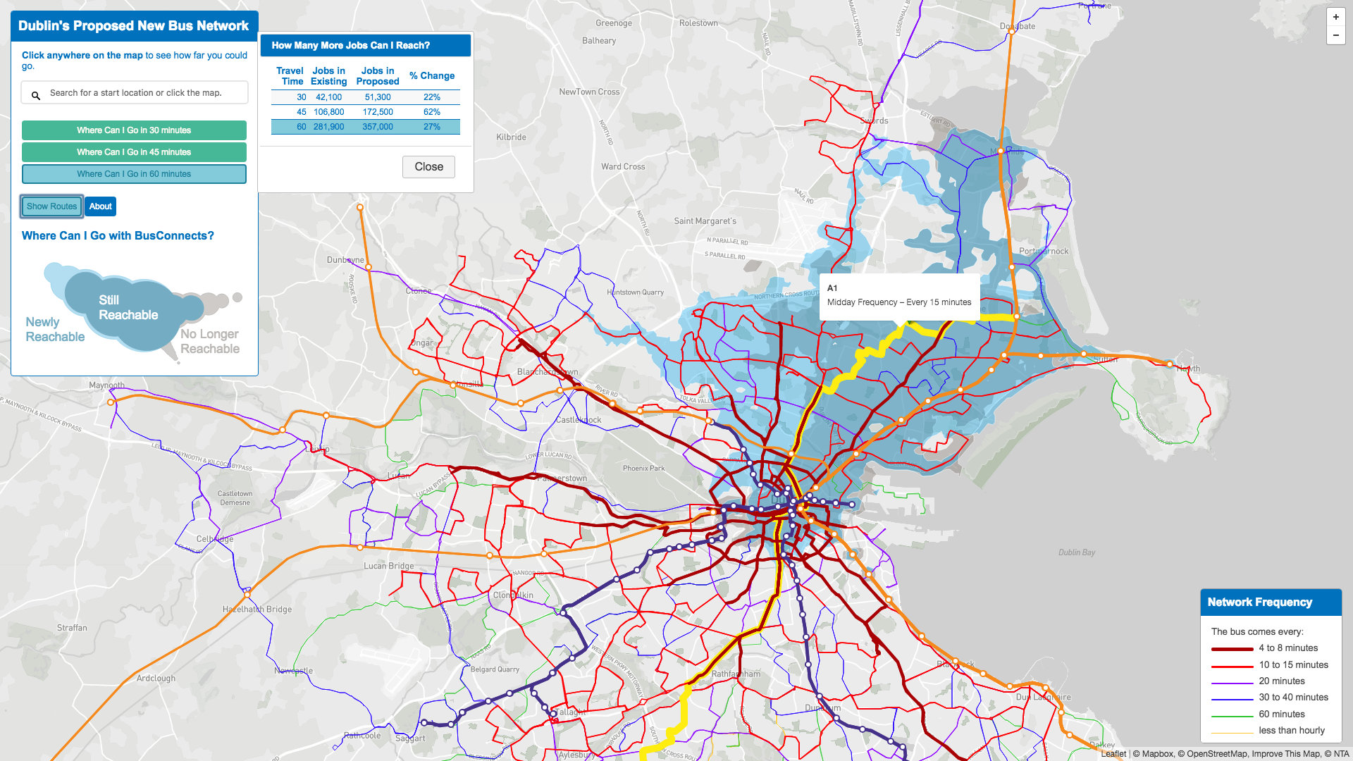
Roll over any route (like we did for the route serving Priorswood here). It tells you that this is Route A1 and the yellow highlight shows you everywhere that A1 goes. Now, it’s not hard to see how you’d go to another part of the city, because you can see where A1 crosses other routes going in your desired direction, and you can roll over them to see what they do.
Many people have asked us for a before-and-after trip planner, giving exactly how a trip would go before and after the change. We are sorry we can’t provide that, but you can get most of that information from exploring this tool. First, the “Where Can I Go?” tool will show you, pretty closely, what a travel time will be from any point to any other, and then the “Show Routes” tool will show you the network. Follow the brightest lines (the most frequent services) that seem to go where you’re going. That’s usually the fastest path.
Footnotes:
[1] Our tool required us to choose colours such that the “no longer reachable” and “newly reachable” colours add up to the “still reachable” colour, while still providing adequate contrast. This turns out to be harder than it sounds.
[2] In short, the midday service pattern (which is also the pattern of much of the evening and weekend) remains the same for several hours, so we can coherently talk about a typical condition. The peak service pattern, by contrast, is changing every minute, so the facts about how long a trip takes are also changing continuously. The result of a peak analysis would therefore be hard to present as a general outcome that would describe most people’s experience. (A peak analysis would also require making many more assumptions that would make the outcome less reliable.) In general, peak results will be similar to midday results in direction (positive or negative) but may be less dramatic in the degree of change.

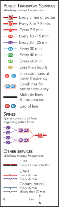 But to understand the maps, you must look at the legend. Our firm’s usual mapping style is dense with information, but therefore contains a couple of things that you need to learn. Most of the early expressions of panic and confusion have been based on misreadings of the map.