Uber’s UberPool service, which attempts to gather multiple people on a single vehicle going the same way, is undergoing some tinkering that will make it even more like fixed route transit. Andrew J. Hawkins at Verge has the story:
[UberPool riders] are being prompted to walk to the closest corner or intersection for more convenient pickups, rather than have drivers deviate from their north-south route.
The same goes for drop-offs, where riders are being let out at a proximate corner rather than the exact address of their destination. Uber calls it “dynamic drop-offs,” but the result is pretty plain. If you want those cheaper fares, you’re going to have to be cool with a lot more walking. Uber began testing this feature last year, and has since rolled it out in wider use.
Does the difference between these images remind you of anything?
Walking further for more direct, useful, and affordable service is the basic deal that fixed route transit has offered for more than a century.
What’s more, if you walk to the bus instead of to UberPool, you can get on any bus instead of waiting for your specific UberPool to arrive.
Yet this is exactly what Uber must do to make their UberPool less unprofitable. As we’ve exploredmany times here, demand-responsive service is wildly inefficient.
UberPool would be less absurd if we were talking about somewhere other than Manhattan, or any other big city that’s rich in frequent transit. In places with less transit, this concept could have some use. But in big cities it’s clearly converging on something for which fixed route transit is already the ideal tool.
Now, New York City bus service has some problems, especially in the delay-ridden way that they handle fares. I am not defending specific practices of any agency. But the geometry remains what it is. If you want affordable transit service, you’re going to have to walk to it. That’s the math that makes fixed route service inevitable.
Transit people all over the world have understood this since long before Uber’s CEO was born. They’ve also known about the concept of demand responsive transit, which means “transit that is extremely inefficient because of the degree to which it deviates or circulates based on the needs of a single person.” Demand responsive service is so inefficient that it arises only in these contexts:
extremely low-wage environments, as in parts of the developing world, or:
focused on elites who can pay high fares, as in typical Uber or Taxi operations, or
for special-needs groups, such as the disabled and seniors, or for other groups that have the power to demand it, always at astronomical subsidies per rider. (Costs per rider for this kind of service, called paratransit in North America, typically run about 10 times the rate for well-designed fixed route service.)
All the new apps have helped smooth out inefficiencies of communication, but they will never change the math. Technology never changes geometry.
As UberPool gradually discovers this, the question becomes: Did Uber, and similar companies, really invent anything at all? They invented apps, and algorithms, but do they have any new answers for the geometry problem that is urban transportation?
(Yes, I said almost exactly this in a post two years ago! But one needs repetition to break through all the noise)
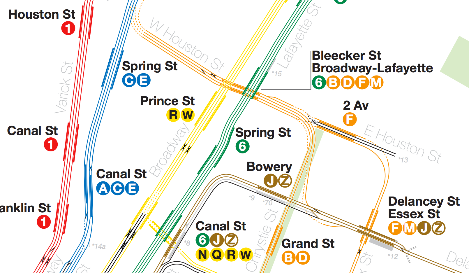
If you’ve never seen a subway track map, I suggest you look at this one, for New York, by “radical cartographer” Andrew Lynch. Most track diagrams are not to scale, and look like they’re meant to make to make sense only to insiders. But this one is beautiful.
What’s more, it’s accurate in geographic scale, though of course the separation of tracks can’t be on the same scale as the network. Still, New York’s subway is both huge and full of details, so this is no mean feat. Only 22 insets were required, to zoom in on tricky segments.
Gazing at a good track map can give you an appreciation for the heroics involved in moving trains around in this limited infrastructure. Switches and extra tracks are very expensive underground, which is why they are never where you need them to handle a particular incident. This, for example, is why a track closure at one station may continue through several stations nearby.
Gaze at this piece of the Bronx, and marvel at what a train would have to do to get from Jerome Yard to a station on the Orange (B+D) line. I presume they don’t have to do this very often, but in a pinch, they can.
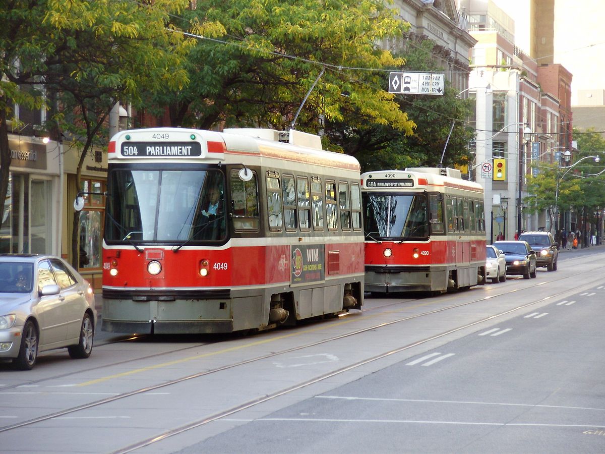
Toronto’s King and Queen Streets — where packed streetcars stop and wait behind one left-turning driver or someone taking forever to parallel-park — is one of North America’s greatest monuments to the natural superiority of motorists over everyone else.
100+ people’s lives inadvertently held hostage by the lady in the grey car at far left. Photo: GTD Aquitaine at Wikimedia Commons
These streetcars are all Toronto has in the way of east-west transit through the very core of downtown, yet their operations are routinely strangled by quite small numbers of cars, running as slow as 6 km/hr (4 mi/hr) (!) during the peak in the most critical section. This for a service that carries the overwhelming majority of the people moving down the street.
We’re talking about the middle of downtown Toronto, the city’s densest and fastest densifying area. For such a place to function, transit just as to succeed.
We’re clear on how dense downtown Toronto is, right? The King streetcar connects this area to very dense residential areas to the east and west.
Since this is Canada, you can be sure these are legacy streetcar lines. Almost nobody outside the US intentionally builds streetcars in mixed traffic, but many cities have inherited them. Long ago, they were reliable because there wasn’t much traffic. But things got worse in the usual boiling-frog manner, and now here we are.
Now, the city is attempting the first step to improve things, by banning through traffic on King Street, one of the two key arteries. Oliver Moore has the story, which sounds like almost every story about a city trying to pry a little space away from the motorist so that anyone else can move. In few places, though, are the motorist’s claims to dominion so indefensible.
The key change will be that cars will be forced right at every intersection, and left turns will be banned. There are still compromises: traffic is still in the streetcar’s lane, and refuges for passengers to board and alight will be marked only with paint.
Yet the plan will still be controversial at Council, with some Councilors arguing that they have a geometrically incoherent “right” or “need” to drive cars anywhere in the city. This plan is a critical step, and deserves enthusiastic support.
Feedspot has identified us as one of the world’s 100 best transit blogs, but more remarkably, we’re at #4 out of these 100, after the World Bank’s blog and two big industry new blogs, Mass Transit and METRO Magazines. That means we can call ourselves the world’s best blog that’s not part of a big institution or journalistic enterprise, and that’s totally self-funded without advertising. Yes, this blog is lightly associated with my (little) firm, but I still do almost all the writing, and it’s still largely my personal work.
There are lots of awards out there, but this feels like a real evaluation, based on a mixture of editorial quality and influence.
By Scudder Wagg. (Scudder is our firm’s new East Coast lead, based in Richmond, Virginia.)
One of the more exciting developments in the Greater Toronto Area is the conversion of historically infrequent commuter rail lines into all-day frequent services, so that you can travel, and make connections, at all times of day. This is creating new rewards for suburban cities who develop more frequent local bus networks. When local bus trips connect to a regional train with minimal waiting, they become useful for vastly more destinations and therefore will attract more riders.
Burlington Waterfront. Photo: László Varga
We are now getting started working with the City of Burlington, in the western suburbs of Toronto, to help them rethink their transit system. The city has been shifting its focus in recent years from a suburban growth pattern to a city that wants to grow up instead of out. Combined with the region’s plans to improve the commuter rail line serving the city to 15-minute service all day, there is a fertile opportunity to rethink the role transit can play in Burlington.
As part of the Greater Toronto-Hamilton Area, Burlington is growing fast but the style of that growth is shifting. For many years, the city sprawled northward from Lake Ontario in a typical suburban pattern. But in 2005, the provincial government instituted a greenbelt, putting a limit on the sprawl. Having hit the greenbelt limit, Burlington has responded by intentionally deciding to grow more intensely.
With so much sprawling growth over the last twenty years, the transit system has been stretched to try to cover as much of the newly developed area as possible. This has shifted the transit system toward a higher coverage focus. The city’s transit system has only a few routes with anything approaching high frequency.
But the city has a strong two-kilometer grid built around the old concession roads that could form the backbone of a grid transit network, although the spacing of parallel grid streets is too far for this to be the only service.
The City adopted a new strategic plan in April 2016 that calls for shifting more trips to walking, biking and transit. They are following this up with a new Official Plan, currently in the draft form, that calls for higher density development in key areas. The draft Official Plan also promotes expanded and improved transit system with a frequent transit network to connect key areas.
We are helping to translate these visions and goals into a concrete network that can be implemented by 2019. That network can then be expanded and improved over time as the city adds more hubs of density and more walkable areas. We look forward to lots of great conversations about transit in this fast-changing and growing city over the next nine months.
Jane McGonigal — the noted game designer and futurist — has a TEDx video about imagining the future. I’ll be speaking at this topic at CNU on May 4, so having loved her book on gaming, Reality is Broken, I was curious about her take.
You can watch it here, or below, but I also summarize it below.
McGonigal’s project here is to undermine that pervasive feeling that we are unable to shape the future. “The future is dark,” she says, not in the sense of bad but in the sense of hard to see into. It is precisely our ignorance of the future that gives us the space to imagine it, and thus to change it.
She tells the story of a futurism class she teaches at Stanford, where she asks students to name things that they are absolutely sure will be true in ten years. Then, she takes this list to researchers and asks how sure they are of those things. Sure enough, there are cases where something that people thought was permanent is in fact changing.
I am totally with McGonigal on the urgency of helping people imagine a more diverse range of futures, but we must also notice how easily this message gets out of control, and how much of the craziness — and destructiveness — of the tech industry arises from this belief in the radically open future.
If I were in her futurism class I could easily name things that will absolutely be true 10 years from now.
The circumference of a circle divided by the diameter of the circle will still be a little over three.
Adult elephants still will not fit into wine-glasses.
There will still be a mathematical limit to how many vehicles — each filling the width of a traffic lane — can fit down a single lane in a state of free flow.
In the absence of barriers to walking, the density of population will still determine the number of people within a fixed, short walking distance of any point. That in turn determine the potential market size for fixed transit, which will govern the level of transit intensity and infrastructure that will pencil out in ridership terms.
Carrying fewer people in more vehicles will consume more urban space, compared to carrying more people in fewer vehicles. This mismatch between demand for road space and its supply will manifest as either traffic congestion or a need to widen roads, removing scarce urban land from other uses.
Those are geometric facts. Within the scale of space and time in which humans live, no invention can change these things.
McGonigal’s rhetoric echoes that of the corporate motivation industry, with its endless implication that nothing is impossible. But as with heated political rhetoric, the danger is always that some people take this stuff literally, and literally, it’s nonsense. The facts about the future I listed above are extremely useful, despite not being ridiculous. They are useful because they keep us from imagining, and spending billions on, truly impossible things.
If we know one thing from watching the tech industry, it’s that the wide-open “anything can happen” futurism that McGonigal praises can be its own bubble, with its own blinders. Much good has happened from Silicon Valley’s willingness to throw venture capital at the occasional wild idea — “moonshots,” they’re called in the biz — but a lot of VC also goes to investing in mathematically impossible things — like moving people from big transit vehicles into small ones without taking up more space — and into attacking folks like me who try to point that out.
In this new era of “disruption,’ urban transportation suffers as much from delusional imagination as from lack of imagination. Only when we allow boring math to constrain our imaginings — and when venture capital gets smarter at recognizing those constraints — can we start to have reality-based conversations about how to liberate people to move in our cities.
Not everything is possible, and it’s a good thing, too.
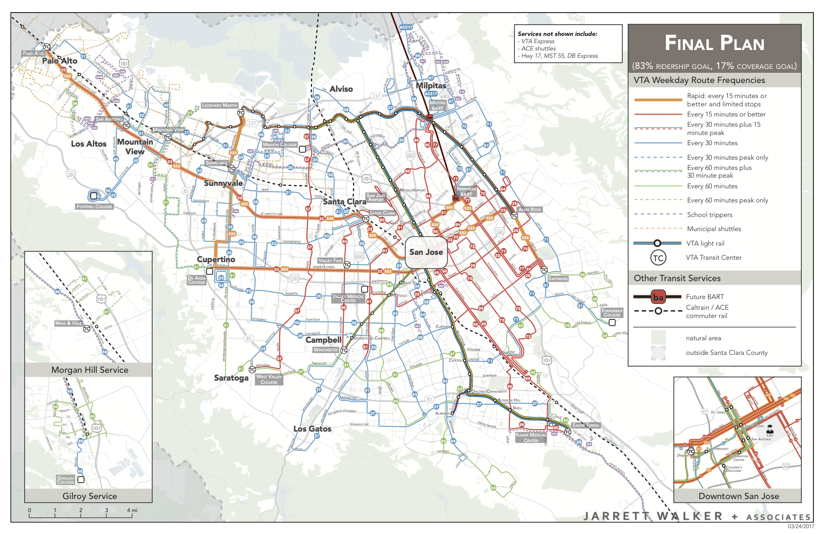
We’re now at the end of a 1.5-year study to help Silicon Valley’s local transit agency, VTA, rethink its bus network. I explained the thinking, and public conversation, that led to the draft final plan in this comprehensive post, and also showed how it compares to the existing one. The final plan looks pretty much like the draft one with a few additions and adjustments.
Here’s the new network. Download a sharper copy here.
The plan is expected to be implemented when the BART extension into the area opens next year.
We’re very proud of this work, and of all the people — in the transit agency, other local governments, and the broader community — who worked with us design and refine it. With this plan, 150,000 more people will have access to all-day high-frequency service, as will 160,000 more jobs. A huge expansion in weekend service is planned. A new rapid bus line is added. (Again, more on the details here.)
Most importantly, more people can get to more places sooner, so that they can do more things and have better lives. And that’s what we’re all about.
Every day, I get at least one email that looks more or less like this:
I hope this note finds you well and thanks for your time in advance. My name is X and I am studying/working at Y. I’m writing something exploring the general topic of Z, and after browsing your blog I know you would be a great person to talk to. Is this something that you would be open to chatting about ?
I am a friendly but busy person who gets lots of these emails. I enjoy talking about interesting issues with interesting people, and will spend some unpaid time doing that.
However, if you want a bit of that unpaid time, you need to offer me one of three things:
Marketing. You might be interested in having us do a study or a paid event. Talking with you is part of my marketing budget, and I’m happy to do that.
Influence. You’re a journalist for a recognizable publication, or you want me involved in a major conference. In that case, I’m trading my time for some influence in the larger conversation, which I’m usually happy to do.
Intellectual Fun. You can’t offer marketing or influence, but you want to have a conversation that’s interesting — to me and not just to you. This can be fun and educational for both of us.
If you ask me a general question that requires me to explain things that I’ve explained in writing, and that I’ve said 1000 times in presentations, well, it’s interesting for you but not so much for me. I repeat myself all the time on the job, and I’m happy to do it, but it’s not how I spend my time off.
In short:
Explore about what I’ve already said on your topic. (Search the blog, or peruse the Basics posts. or watch some videos you can watch, or read my book, whose introduction is here.)
Form interesting thoughts about that. Reasoned disagreements are especially welcome.
Start a conversation with those thoughts.
That’s what I did when I was in your shoes, as a geek and advocate with no relevant connections, job, or influence. It worked.
So if I didn’t respond to your email, this is probably why. (Though sometimes, I admit, I’m just too busy.)
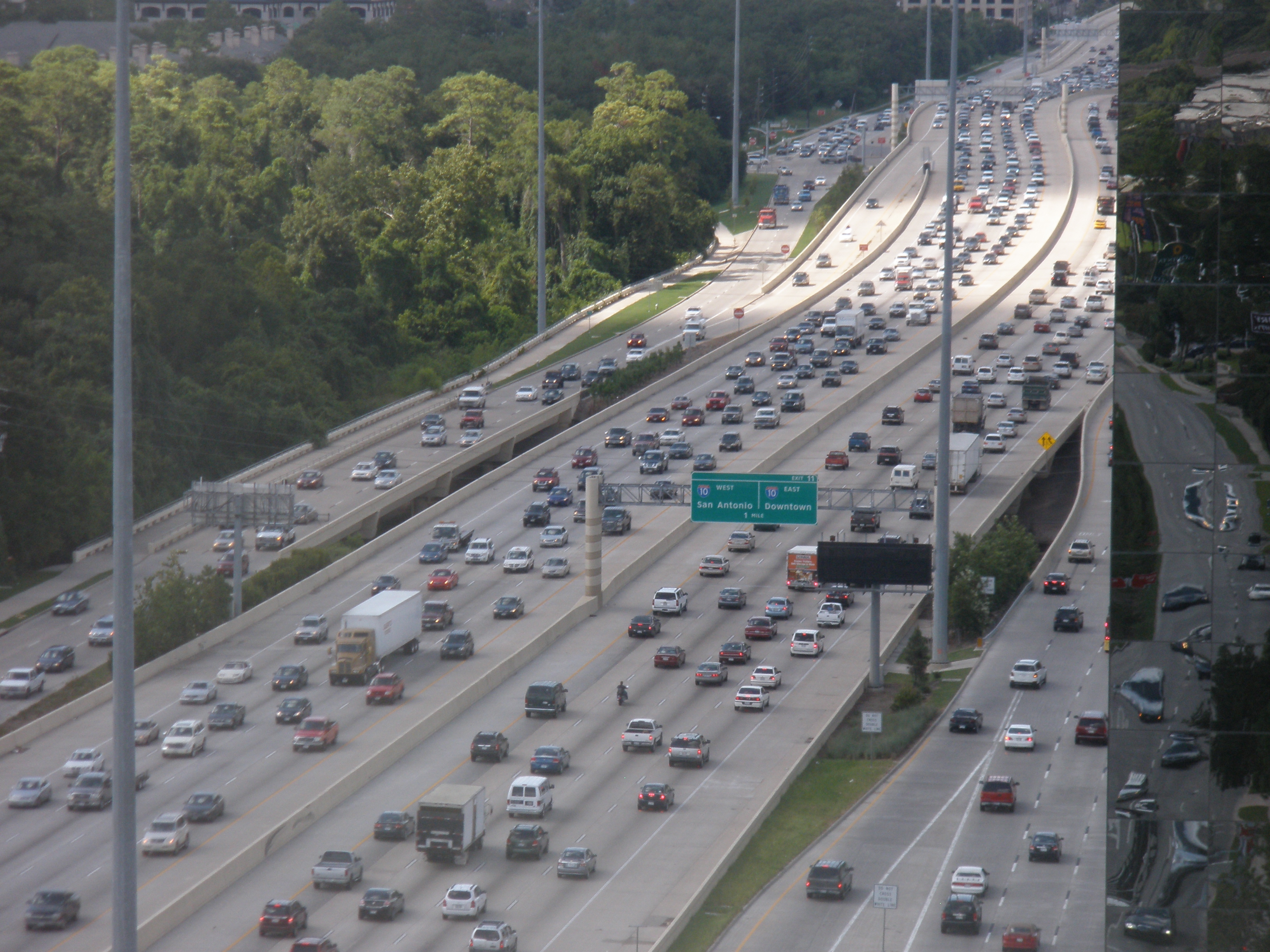
Houston’s West Loop Freeway. How many of these lanes were in the national interest?
We all need to practice reading and refuting arguments of the form: “Central government should focus on big national issues, like highways, instead of local needs, like transit.” It’s become one of the most common ways for people to dress up their preference for roads over transit as an expression of a consistent policy.
For the most part, transit systems are local matters. Using federal taxes to collect money from the whole country and then send it back to each local transit system is a terribly inefficient way to raise money for transit and is also inherently unfair as different locales receive back either more or less than they paid in. The only reason to rely on federal funding for part of the cost of local transit systems is that it helps local politicians by keeping their local taxes and transit fares lower.
This common practice of using federal funds for local projects in order to hide the true cost should be stopped. The federal government should pay for the things that are truly national in scope (like the interstate highway system). This type of federal spending for local needs encourages too much government spending by making higher costs easier to sell to voters. The federal government should stop being used as an enabler to higher local government spending.
That’s University of Georgia economics professor Jeffrey Dorfman, in Forbes yesterday.
Dorfman seems to invoke the principle of devolution — the idea that government actions should be planned and funded at the lowest level of government that can deal with the issue within its boundaries. It’s often stereotyped as a conservative idea in the US, but it shouldn’t be. In the UK, for example, it’s mostly the leftist cities who are rebelling against over-centralization of planning power in Westminster. The same idea is gaining force in US urban policy, as cities chafe under rule by central governments that care only about suburbs and rural areas. Everyone prefers to deal with more local governments that are easier for a voter to influence, so this is a space of potential left-right agreement that deserves more discussion.
But the notion that highways are national while transit is local? This makes sense if you’re a motorist, but here’s what happens when you press on it:
@humantransit Because it is possible to drive on the interstate from state to state (as truckers and some drivers do), while subways are local. Period.
If the test for Federal funding is that a facility is used for interstate travel, fine, but this suggests a coherent interstate network of roads and rails scaled for the interstate demand only. Then, all additional capacity and upgrades needed for travel within a state would be state and local costs. What would this mean?
The Federal government would invest to create a robust interstate road network sized to interstate needs only. In urban areas, the Federal government would fund only as many lanes as are justified by cars and trucks originating outside the state. That means two lanes at most, and it means that many Federally funded highways would have no Federal role at all.
The Federal role in airports and maritime transportation would be viewed the same way.
The Federal government would also fund interstate rail (passenger and freight) to the degree that this is a better investment than roads for serving interstate needs. Interstate high speed rail improvements would be squarely Federal.
Finally, many US metro areas span state lines, so a large part of the costs of urban transit in those cities would be Federal, as it would count as interstate transportation.
Nobody would propose this policy, but only for the boring reason that it’s biased toward multi-state metro areas: The Northeast wins big while California and Texas lose. But if you could control for that, this would be a coherent principle of devolution such as Dorfman seems to be advocating.
But our car-first friends never make that argument. Instead, they just handwave about how of course highways are naturally national while those other things are local. In fact, the distinction between interstate and intrastate doesn’t line up at all with distinctions among road, rail, maritime and aviation modes — either passenger or freight.
This is why you should see through these familiar arguments, and recognize them instead as sheer claims to hegemony: “We road people are superior, so of course money should be spent on us — including giving road-based services a leg up in competition with other modes.”
“We have no history of funding urban rail and I think it’s important that we stick to our knitting,” the Federal Opposition Leader declared. “And the Commonwealth’s knitting when it comes to funding infrastructure is roads.”
In his autobiography, Abbott wrote about how driving a car is a quintessential Australian experience, a key to the national character. He is also known for an extreme social and cultural conservatism that is toxic in inner cities. So even among those who agreed with him, Abbott’s comments were widely recognized as an expression of a cultural agenda, not an economic one. While nodding at devolution, he was really saying that road people like him are superior to those urban transit people, none of whom will ever vote for him anyway.(1)
When you see arguments like Dorfman’s, that, I’d suggest, is what you should hear. Devolution itself is a powerful idea, but we’ll never have a clear conversation about it if it’s only used to make claims of superiority.
(1) Abbott was deposed in 2015 by Malcolm Turnbull, an urban conservative from a wealthy part of Sydney. Turnbull dumped Abbott’s roads-first view, stressing instead that Federal transport investments would be multimodal. Despite its powerful rural interests and cultural identity, Australia has a strong bipartisan consensus that its national economy depends on the functioning of its cities.
Real estate giant Redfin (which owns WalkScore) has a study about how transit quality correlates with property values. And yes, there’s a correlation:
On average, across the 14 metros analyzed, one Transit Score point can increase the price of a home by $2,040. But the price premium varies widely from metro to metro.
That variance is a problem, though. For example, a Transit Score point gains you 1.13% on property values in Atlanta but counts for nothing in Orange County, California. When you see this kind of variance, you should suspect that other factors are more significant than the one being studied. So this supposedly pro-transit Redfin piece can actually be used to argue that transit isn’t all that important, or at least that when transit is important, it’s because it echoes something else that matters more.
But we should explore a simpler explanation: Maybe transit is relevant, but Transit Score isn’t.
I explain what’s wrong with Transit Score here, but the bottom line is that Transit Score has nothing to do with where you can get to on transit. Transit Score is about how much transit is nearby, and whether it’s cute or sexy, but not at all about whether it’s useful. In this it’s much like the way the real estate industry evaluates static civic amenities, like schools and parks, whereas it should be more like the way the same industry evaluates road access, i.e. by caring how fast you can get to places. More here.
This is important because when you publish results with such huge variability, you tip off smart people that you may not be looking at the right explanatory variable. It’s easy to look at these results and assume that transit isn’t what matters. But maybe it’s Transit Score, not transit, that’s the distraction.
/cdn0.vox-cdn.com/uploads/chorus_asset/file/8553597/NYC_POOL.jpg)