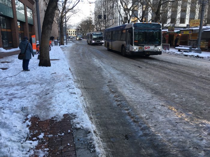
Author Archive | Jarrett

Core vs. Edge Debates in Public Transit

In just about every North American regional transit debate I’ve ever been involved in, someone has said:  “Why is all this money being spent on transit downtown!  Downtown already has lots of transit, while out here in ___, we have nothing!”

If this is a debate within a city — often between city councilors who represent districts — then they’ll say this about downtown, and sometimes about dense inner neighborhoods around it.  But exactly the same debate happens at another scale: among municipal governments in a huge urban region; in that case, they’ll complain about the entire dense, old, transit-oriented city at the region’s center.   In either case, I’ll use the term core to mean the older, denser, inner area in this debate, and edge to refer to the newer, less dense, more car-dependent area.

Either way, the debate sounds like this:

Edge:  “The core area has so much transit, and we have little or nothing, but we pay taxes too, so why does so much of the money go to the core?  Also, we’re trying to build denser development in more transit-oriented ways, to start moving beyond car-dependence, but how can we do that without good transit?  We’re desperate out here!

Core:  “It’s great that you want to be denser, but we’re already very dense.  That means a much bigger share of our residents need or want transit, and our ability to grow and thrive depends on it.  Car-dependence just isn’t an option at our density, so if transit doesn’t work, our city doesn’t work.   We’re desperate in here!

I sympathize with all sides, and do my best to warn all sides away from this kind of parochial polarization.  Nothing is sadder than coming into a city or region with inadequate transit, and finding that the locals are more interested in blaming and resenting each other than in working on a problem they all share.

Once more with feeling: Transit is a network, which means that its parts are interdependent.  You cannot think about it the way you think about libraries or fire stations, where putting one in a certain place mainly benefits the people there, because the whole network affects everyone’s ability to get everywhere.  So when folks argue that the another part of the network should be weaker so that theirs can be stronger, they’re actually undermining their own transit service.

In North America, the edge tends to have the votes to win edge-core debates, so it’s not surprising that many North American transit networks are weak at the core.   When you look at North American rapid transit systems, you often notice pieces missing in the middle.  Metro Vancouver is one of the most dramatic cases.  Look at what happens at the west end of the yellow line:

vancouver skytrain with gap

It never ever makes sense for a major rapid transit line to end just short of where it would connect with another major line, as the yellow line does here.  This gap creates all kinds of overloading problems, as three suburban branches from the east all feed into a single line into downtown (the northward peninsula).  It obstructs many cross-regional trips, most obviously from the eastern suburbs to the airport (on the island in the lower left).   Finally, the bus line that crosses this gap is one of the busiest in North America, the best signal of all that you need a rail line.  Yet if you listened to the regional transit debate, you’d think that plugging this gap in the whole region’s network is a project “for Vancouver” just because the gap itself happens to be in Vancouver.

Once you learn to recognize it, you’ll see this theme in city after city.  Missing links like Vancouver’s are an extreme example.  More common is a persistent disinvestment in the core parts of a network even though people from the whole region rely on those parts.  Many big city transit networks end up massively overcrowded and failing at the center even as the political pressure is all about extending further toward the edge.

Fortunately, a few North American regions are showing real leadership and progress on this:

  • Toronto is under political pressure to extend its subway lines further into the suburbs, adding even more riders, even as the inner segments of the network are severely overloaded.  Where would all those passengers fit?  The only solution is another subway through downtown, but as soon as you mention downtown, a majority of the City Council has had trouble seeing why they should care.  Major progress has been made on advancing this crucial “core-strengthening” project in the last year.
  • Los Angeles Metro is building its Regional Connector project, a new subway under downtown whose purpose is to hook together rail lines that now terminate on opposite sides of downtown, never touching each other.  For long trips across the region — from Pasadena to South LA, say, or from Santa Monica to East LA, the connector replaces two-transfer trips with zero-transfer trips (which means it also replaces three-transfer trips with one-transfer trips), so it dramatically increases the ease with which you can get across the larger city.  LA Metro produced a very smart map with wide two-way arrows showing these improved regional flows. The agency did a great job of helping people see that while the project is in downtown, it’s for the whole city and region
  • Last month, there was major breakthrough in the Seattle area.  The Sound Transit 3 regional rapid transit proposal, which will go to the voters in the fall, requires a new subway tunnel under downtown, parallel to the existing one two blocks away.  Until last month, the entire cost of this tunnel was considered a Seattle expenditure, so it completed for funds with other city projects.  But of course, Seattle doesn’t need another subway tunnel two blocks from the existing one.  It’s the whole region that needs it, to fit all of the region’s rail lines through Seattle.  So the final plan, correctly, treats this is a cost to be shared across the region.

Finally, why have I said “North American” throughout this post?  Because most other wealthy countries I’ve worked in or studied don’t have this issue to the same degree.  Mostly this is because those countries have located regional transit planning at a level of government that has the power to see and act on a citywide vision, and account for all of its consequences.  Typically, this power is integrated with the other great powers that act on that scale, such as land use planning, infrastructure, and so on, so that the implications of each action can be accounted for.

Good planning can still happen in a more fragmented political context, though, so long as someone has the power and skill to make the argument for a complete network vision.  Fortunately, this is happening more and more.

The Chinese Straddle Bus is Back

Yes, the Chinese straddle bus is back.  “Back” because you read about it here six years ago.  A wide flat vehicle that spans the travel lanes of an expressway, so that cars can drive under it.  As I observed back then, its most interesting feature is the way it collapses what little remains of the difference between bus and rail.

6a00d83454714d69e20133f41813d2970b-800wi

And yes, if your starting point for urban design is that single-occupant cars, despite their extreme inefficiency in using scarce urban space, should be allowed to go anywhere at all, and that the surface plane should be designed solely for their convenience to the exclusion of all other citizens and needs, then this technology makes sense.

Remember, the primary cost of transit infrastructure is the cost of keeping transit out of the way of motorists, on the assumption that motorists have the prior claim to absolutely every bit of public space in our cities.

Meanwhile, Cap’n Transit has the best parody.  Not that I don’t take this seriously, at least as a scalpel for prying open the deep assumptions of infrastructurism.

What are Transit Consultants For?

JWlogoSquareThis is going to sound a little like marketing, but it answers a common question or objection.

Why do you need consultants for your city’s transit plan?  Other consultants will speak for themselves, but here’s why you might need a consultant like me.  Inevitably, this list is also a definition, in my mind, of what makes a good consultant, at least for transit network design.  It’s what we strive for at our firm.

  • Experience with Lots of Cities.   Your city is unique, but the facts of geometry, the facts of biology, and many human longings and foibles are the same everywhere. I’ve worked in (or studied) about 100 cities and towns, so I can see what’s unique about your city and exactly what’s just like everywhere else.  This perspective is helpful to locals, who don’t all get to make that comparison every day.  In particular, I can help you take some of the fervor out of local arguments by pointing out that many cities, at this moment of history, are having the very same conversation, featuring the same points of view.
  • Ability to Foster Clear Conversations.  Because of that experience, we cut through a lot of angry chaos in the local conversation, and frame questions more constructively.  This doesn’t mean we make hard decisions go away; in fact we often make them starker.  But we also make them clearer, so that if the community makes a decision, they actually understand the consequences of that decision.
  • Maximizing Your Community’s Options.  Unlike a lot of consultants, we hate telling communities what they should do.  We prefer to show them what their options are, and let them decide.  But laying out options is really hard.  You have to show exactly where the room to maneuver is where where it isn’t.  That requires the next two skills.
  • Clarity about Different Kinds of Certainty.  As consultants, we know when we’re in the presence of a geometric fact rather than a cultural assumption or a personal desire.  Only when we accept the facts of geometry (and biology, and physics) can we know what a community’s real options are.
  • Ability to Argue from Shared Values.  Good transit consultants don’t just talk about peak loads and deadheading and value capture and connection penalties.  They also talk about liberty and equality and durability and prosperity and aesthetics.  Then, they explain why those big ideas for your city imply that you should care about this or that detail of your transit system.
  • Skill at Synthetic Thinking.  Synthetic thinking is the ability to generate insights that solve many problems at once.  It’s what you need to do to create a scientific theory or design any complex system.  Synthesis means “putting things together,” so it’s the exact opposite of analysis, which means taking things apart.  Synthesists rely on the work of analysts, but you will never analyze your way to a good network design.  The skill of synthetic thinking is impossible to teach and can only be recognized where it appears, but a fondness for thinking abstractly or theoretically is a good indicator of it.  And since network design is rarely taught in universities anyway, the best evidence of this skill is a track record of having done it successfully, in lots of cities, plus (very important) the ability to explain it to a diverse range of people.
  • Skill at Spatial Thinking.  Finally, the specific kind of synthetic thinking needed for network design is spatial.  People who like designing and solving problems in space — architects, military strategists, chess players, visual artists, and kids or adults playing with trains — are likely to be good at it.

The  biggest public transit authorities, in the most transit-sophisticated cities, may have people with all these skills on their staff, because they are questioning and improving their network all the time.  But most transit agencies don’t, and that’s understandable.  In most cities, you don’t redesign your transit network every day, or even every decade, so it’s inevitable that most of the staff of the transit agency has never done it before.  Relatively few transit agency jobs require, on a day-to-day basis, the skills that make for good network designer, especially for large-scale redesign.  So those agencies will benefit from some help.

Consultant, of course, is a much-sullied word.  For one thing, many consultants go around telling people what they should do; we do this as little as possible.  Many consultants just teach you to envy other cities, which appeals to certain human desires but is also not the best basis for good decisions.  Some consultants speak in ways that are incomprehensible to most people, or refuse to explain things clearly, so as to sound wise or authoritative.  (“Our proprietary six-step model with a Finkelstein regression says you should build this freeway.”)   A consultant who can’t make a reasonably intelligent and open-minded person understand their work isn’t one you should trust — especially when it comes to network design.

See, network design is like chess.  The rules are pretty simple.  I explained them in my book Human Transit and in this blog’s Basics posts, and I keep trying to improve on those explanations, here for example.  But doing it is hard, and you can spend years getting better at it.  So it helps to have someone at the table who has done it many times, who knows how to see the patterns of opportunity in your city’s geography, and who can explain why an idea works, or doesn’t.

Lean into the Wind

We live under a constant barrage of advertising — messages from companies who want us to do or believe something that’s profitable for them.  And in case you haven’t noticed, the barrier between advertising and news is tenuous, not just because of advertising disguised as news, but because journalists are human.  Sometimes they’re personally dazzled by celebrity, and in any case they’re under pressure, as they’ve always been, to tell stories the way their powerful sources want them told.

This is a big issue in urban transportation, because so much journalism on the topic, especially “tech” journalism, is generated under these intense pressures.

So here’s a basic habit that will help you think more clearly about urban transportation and tech issues.

Lean into the wind.

To stand up straight in a high wind, you need to lean into the wind, that is, opposite the direction that the wind is blowing.

To keep your cool while under a barrage of self-interested messaging, such as what’s coming out of the tech companies, you must do the same.  You must notice which views are being obsessively repeated and be more skeptical of exactly those views, and only to the degree that they are being exaggerated.   That doesn’t mean rejecting those views, but it means holding them to a higher standard because they are obviously dominating the media narrative for reasons other than their objective value.

If you just accept the intensity of the media narrative as evidence of its truth, you fall over in the direction that the wind is blowing.  If you just reject all those messages and assume the opposite of what the media narrative is saying, you fall over in the other direction, which makes you equally helpless.   Either way, once you’ve fallen over, you can’t see what’s going on.

So lean into the wind just far enough so that you can stand up straight, and see.

Another good corrective is to remember that, contrary to all the claims of advertisers since the dawn of time, “new” does not imply “better,” because (1) most innovations fail and (2) many innovations that appear to succeed turn out to have bad side effects that you could have foreseen and that your grandchildren will curse you for.

All this is relevant because the media wants to talk about the new and not about the old.  That’s because corporations want to talk about patented and therefore profitable things, not great ideas already in the public domain.

But many old things work well.  Mobile phones still drop more calls than landlines do.  Software updates routinely introduce new bugs and destroy functionality that the user valued. When I give a public lecture, the rapidly vanishing clock on the wall is much more useful to me than a clock on my phone.

So it makes sense, always, to question all claims of novelty and ask:

  • What will the world be like when everyone depends on this invention?
  • What is already working that this invention proposes to destroy but may not replace with something better?

The high wind of self-interested marketing doesn’t want you to ask those questions, so you must.


Seattle: The Future of a City’s Liberty

If you know the Seattle area at all, you’ll enjoy this simple yet deeply pleasing animation by King County Metro Transit, showing how transit could improve over the next 25 years, if voters continue to support it.

What kind of video is this?  No pictures of diverse, happy people on public transit? No pictures of sexy trains or buses?  No network diagrams? (Those are here!)

Nope.  Just pictures of the liberty and opportunity of human beings, like this:Slide039


This image means that in 2040, if you’re in the Fremont district of Seattle (the center of the dark green dot) you’ll be able to get to anywhere in the brown area in 60 minutes. The animation steps you through how small this area is now, and how it grows over time under the plan.  It does this for over 70 sample destinations around the region.

If you want to get around on transit and walking, think of this brown area as the wall around your life.  Make it bigger, and your life is bigger: more jobs you could hold, more schools you or your kids you could go to, more clubs you can belong to, more people you can meet, befriend, maybe even marry.

At my firm, we almost never do a plan anymore without drawing these, showing how they differ based on various alternatives under study.

Because we think people are tired of arguing about rail vs buses, and about transferring, walking distances, waiting times, dwell times, platform heights, and all the other arcana that make most transit conversations seem maddening and inaccessible.  Instead, we want to talk about something everyone cares about: liberty and opportunity.

Diagram by King County Metro Transit, part of their “Metro Connects” strategic plan.  Produced in Remix.  

Guest Post: Review of Ryan Gravel’s “Where We Want to Live,” by Mark Pendergast

9781250078254-2

Where We Want to Live: Reclaiming Infrastructure for a New Generation of Cities, by Ryan Gravel (St. Martin’s, 2016).

About the reviewer: Mark Pendergrast is an Atlanta native who is writing a book about Atlanta with a focus on the BeltLine and its adjacent neighborhoods. It should be published by Basic Books in the spring of 2017. You may reach him through his website, www.markpendergrast.com.

Ryan Gravel is one of the few living American architects/city planners who can legitimately be called a visionary. His 1999 master’s thesis at Georgia Tech envisioned a streetcar loop inside the Atlanta city limits, to connect four separate railroad lines, mostly termed “belt lines” when they were built in the late 19th and early 20th centuries, because they formed a kind of belt around the central city. They lay only two or three miles in radius from the city center, and aside from one section in the northwestern part of the city, they were mostly abandoned. In fact, most parts were covered with kudzu vines and homeless encampments. By reviving these forgotten, neglected corridors, Gravel wrote in his thesis that “the Belt Line should accomplish more than just an improved system of public transportation. It has the potential to change the way we look at Atlanta.” Instead of dividing neighborhoods, the old railroad tracks could reconnect “home and destination, rich and poor, black and white.” Perhaps the city’s problems could lead to its salvation. “Troubled by pollution and congestion, Atlanta can seize this chance to redefine itself,” he wrote in his thesis.

Gravel never expected his thesis to become reality, but that’s exactly what is happening, and his original vision has expanded to include a walking-hiking trail and new parks. In this book, Where We Want to Live, Gravel briefly summarizes how the BeltLine (as it is now spelled) project came into being, initially through grassroots efforts that he helped to lead. But the main point of his book is a big-picture exploration of how re-inventing old infrastructure can help to remake our cities into places where, as the title says, we actually want to live – in a greener, more walkable, more intelligently developed way, with denser residential patterns, mixed-use developments, fewer automobiles, and more walking and biking.

In this book, Gravel, who now travels the world to advise other cities, discusses not only the Atlanta BeltLine, but many other “catalytic infrastructure” projects, among them New York’s High Line and prospective East River Blueway, Miami’s Underline, Philadelphia’s Rail Park, Detroit’s Dequindre Cut Greenway, the Los Angeles River restoration, the Iron Horse Trestle in St. Louis, the Harismus Stem Embankment in Jersey City, the Midtown Greenway in Minneapolis, Lafitte Greenway in New Orleans, Buffalo Bayou Park in Houston, S-Line in Salt Lake City, Singapore’s Rail Corridor, Vancouver’s Arbutus Corridor, Buffalo’s Belt Line, Paris’s Promenade Plantee and Petite Ceinture. All of these projects are reinventing old infrastructure (mostly abandoned rails).

I do have a few quibbles with the book. Gravel provocatively entitles one chapter, “There’s Nothing Wrong With Sprawl,” then proceeds to tell us everything that is wrong with sprawl. Also, he does not go into any detail on all of the challenges that the BeltLine faced in coming as far as it has. There have been enormous problems, involving legal challenges that led to a state constitutional amendment, a last-ditch effort by Amtrak to take the northeastern section, the Great Recession demolishing income estimates for the BeltLine tax allocation district, an unworkable contract with the Atlanta Public Schools, and more, so that it’s quite miraculous that the project is still coming along. And it is unlikely that the entire project will be finished by the 2030 target date. In fact, it isn’t even clear if streetcars will make it onto the corridor along with the walking/biking trail (though a new city tax to support MARTA, Atlanta’s rapid transit, may provide hope). These are issues Gravel does not cover in this book. (I should reveal that I am working on a book about Atlanta, my birthplace, which will be a good complement to Gravel’s. I am focusing on the BeltLine project in much greater detail. Gravel is one of the major characters in my forthcoming book.)

But these are really minor cavils. What Gravel has done here is to offer a clarion call, a sermon if you will, to support these innovative urban projects. In his final chapter, he exhorts readers: “By experimenting with new ideas, cultivating a political structure for change, stopping sprawl, and shifting to more sustainable growth strategies, we can generate significant and positive change…. Whatever road we take to get there, we will have to build broad support around an aspirational view of our future. This will require us to dream, think, and plan, but we will also need to take action….”

Ryan Gravel’s book should be required reading for city planners and those who care about our future.


Jane Jacobs at 100

17285When Jane Jacobs died 10 years ago, I wrote this on the personal blog:

Jane Jacobs, 1916-2006

(If you don’t know who she was, please read the NYT obituary.)

When news of her death arrived, I was in the midst of an event that would have been inconceivable without her work:  a four day intensive planning workshop — called a charrette in planning parlance — designing a new light rail line for several suburbs east of Vancouver.  

When I worked on one of North America’s first modern light rail systems, in Portland in the 1980s, the agency put out videos showing that statons could be built in low-density, single-family neighborhoods without affecting them in any way.  To tell the truth — that rapid transit projects would energize denser and more vibrant citybuilding — would have roused terrified homeowners to kill the project.  

Today, almost everyone sees rapid transit stations as magnets of convenience around which vibrant, very dense cities can gather.  None of the suburban cities at our table wanted rail stations to serve their existing sprawl.  They wanted them to galvanize a new high-density urban future, while preserving historical qualities of their communities that give them character and uniqueness.  They wanted to create mixed-use places — housing over retail mixed with offices — so people could live complete lives while making many of their daily trips on foot.  And though it wasn’t mentioned, they mostly opposed a nearby freeway widening project, which threatened them with more traffic than their roads could accommodate while remaining civilized places. 

These were Jane Jacobs’s themes, in her writing and activism in both New York and Toronto.  In New York, she will forever be juxtaposed with the mid-century city-builder Robert Moses, who saw cities as confusing messes that needed to be taken apart into abstract systems of order:  towers surrounded by parks served by freeways.  Her 1961 masterpiece, The Death and Life of Great American Cities, did more than challenge Moses’s vision, and the devastation it was wreaking on New York.  It reread the seeming jumble of cities — the random mixtures of many kinds of people and activites — as the essence of civic health.   Today’s consensus among urbanists is her insight.

I felt a special kinship and admiration toward her, because like me she was formally uneducated in her field of practice, and massively suspicious of the planning establishment.  In her day, the entire field of urban planning had succumbed to beautiful abstractions:  Dense, congested mixtures of activity were bad.  Surprises and happenstances had no place.  In a beautiful city, everything should be separated, like pieces in a museum or butterflies pinned to the wall for study.  The beautiful city would have free-flowing freeways, garden suburbs, towers in parks.  

Jacobs first noted that the results of these visions were less vibrant than the “slums” that had been bulldozed to create them, that the very features that made cities seemingly inefficient were those that made them great places where people loved to be.  But she thought beyond this simple opposition to develop a theory of cities based not on what she read, but on what she saw.  Jacobs, who never finished college, built her extraordinary career on a relentless return to the evidence of her senses.  Her best books rest on lyrical and yet finally analyzed descriptions of the life of a street, showing how it functions as an ecological fabric as sound as the one that nature spins in the wilderness, one that produces not just livelihood but also joy.

Fellow environmentalists — you who sing the minute brilliance of the natural world — read Jacobs, and understand those of us who would protect nature by cherishing cities.  In dense cities we not only use resources more efficiently, we also expose ourselves to the cacophany of happenstance, daily offerings of mutation that drive the evolution of humanity.


Anchorage: Come Talk Transit on May 5

Updated TransitTalks Banner

IMG_7096We’ve been studying the transit system in Anchorage, Alaska for the last few months, and this Thursday May 5 I’ll be in town for an evening event.  I’ll do a keynote providing an overview of the transit planning challenge and exploring what we’ve found out about your transit system.  (Did you know that on average, your buses are more crowded on weekends than on weekdays?).  There will be plenty of opportunities to get involved and express your views.

See here for more information about the event.  Our most recent detailed report on the system and its prospects is called the Choices Report.  <– Download it there!

Yekaterinburg: An Intense Week in Review


For the last 10 days, I’ve been in Yekaterinburg, Sverdlovsk Oblast, Russia.

IMG_7921
IMG_7900

IMG_7648
IMG_7567It’s over a million people in a remarkably compact city at a dam on a river, in the midst of taiga forest (spruce, birch, larch, pine).  In fact, it’s by far the most dense and compact Russian city of its size, which means they need to get used to being a national leader in public transit development.

And yes, it already has a lot of transit.  In this first picture, note the trams, full-size motorbuses, and, at the crowded stop in the distance, trolleybuses and tiny van-like buses.  There’s also a metro.

IMG_7569.JPGIMG_7663

IMG_7574 IMG_7792.jpg

Still, it’s OK if you haven’t heard of Yekaterinburg.  A year ago I’d barely heard of it either.

But last year, an energetic local NGO called Gorod.pro, which is dedicated to improving the city’s transport and urban environment, called me, and I do my best to say yes to these things.

Yekaterinburg presents a series of transit situations common in middle-wealth places, but that I’ve also struggled with in Australia and New Zealand and the UK.  As I outlined in more detail here, the city has evolved several overlapping transit systems that compete as much as they cooperate, and as a result you can’t get to as many places as quickly as you could if they were all working together.  The trams, trolleybuses, and motorbuses overlap each other and also overlap the single metro line.  And there are about 1000 smaller buses, down to the size of vans, that do all kinds of unpredictable things, including driving rather dangerously in order to get ahead of big buses and grab their passengers.

So I was asked to work with local leaders and transit managers to hammer out a vision — including a specific map — of what that would look like.

I’m always happy to slip quietly into a city, but that certainly didn’t happen here.  The client wanted a splash, so all week I was doing public lectures, radio interviews, and high profile meetings with the City Manager, his key deputy for transportation, and even the mayor, Yevgeny Roizman — all with lots of reporters.

IMG_2067

Mayor Roizman was especially generous with his time and interest.  In addition to our formal meeting in his office he also gave me a tour of a museum of icon painting that he founded. He also joined us for a few hours of touring the city, often interrupted by eager citizens wanting a photo with him.   He even dropped into our working sessions, with chocolate.

For much of the week, I was sequestered with a group of key staff leaders, including senior managers from the various transit operating companies and city transport and planning staff.  As I insist on doing in most of my planning projects, we locked ourselves away for 8 hours a day to hammer out a shared vision of how the city’s transit might be better if it were planned as a single network.  An excellent set of photos by Gorod.pro gives a sense of the intensity.

IMG_3091IMG_3101

(The guy drawing is Vladimir Zlokazov of Gorod.pro.  He was my main contact, advisor, negotiator and translator throughout the project.)

IMG_3039IMG_3110IMG_3017

At the end of the week, we had a sketch of how the network could look if everything worked together.  We had tram, trolleybus, and frequent motor bus lines drawn specifically, and a general set of principles for how the enormous fleet of smaller buses would supplement this network.

We also identified some of the biggest challenges for moving forward:

  1. Fixing the fare system.  The current fare structure charges people for changing vehicles, which undermines the whole point of a highly efficient network.
  2. Reorganizing operating contracts, so that the only revenue total that matters is that from the entire network.  This is essential to eliminate competitive behavior between subsidized services, so that the result is the maximum possible access to the city for everyone.
  3. Maintaining separability from other issues.  There are 1000 other things to be done to improve transit, notably in the area of infrastructure.  But almost none of it has to be done to get the new network on the road.  We worked carefully to make sure we had a plan that didn’t require building anything more than bus stops, and that had a first phase that didn’t even require that.  This is the key to ensuring that a network plan doesn’t get stuck waiting for something to be built.

A report on this network, its benefits, and the challenges it will present, will be out soon, and I’ll do a post on it here.


(Workshop photos: Gorod.pro)


Why the Media Fixation on “Transit is Failing” Stories?

Recently, I took issue with the Los Angeles Times for telling a  “ridership is falling” story, even as they published a chart that cast doubt on that claim.

Now here comes the same distortion in Silicon Valley’s San Jose Mercury News.  Look at the chart:

20160415_101955_SJM-VTA-0418-90_300

The chart title contradicts the chart.  The transit agency’s ridership has not been in any serious decline since 2005.  The truth is that it fell steeply from 2000 to 2005, and had a small drop in ’09-10 related to the financial crisis and related service cuts.  Otherwise, ridership has been tracking pretty well with population.

Now, here’s how the Mercury News spins it:

Staggering drop in VTA bus ridership may signal dramatic changes

Despite a Santa Clara Valley population and jobs boom, ridership on buses and light-rail trains has dropped a staggering 23 percent since 2001, forcing the Valley Transportation Authority to consider its biggest shake-up ever in transit service.

 The decline comes as new BART service into the South Bay is projected to spill 23,000 more transit riders into the VTA region next year.
As their own chart shows, ridership is down since 2000 but up since 2005.  The Mercury News is just playing the old arbitrary starting year game.  If you want to tell a story about ridership collapse, just pick a high starting year for your comparison.  If you want to tell a story about ridership soaring, pick a low starting year.  Both kinds of stories are bogus.

From this silliness, the article above spins vast webs of misinformation. Notice how you’re supposed to conclude …

  • … that VTA is in a crisis today.  No, VTA was in crisis 10-15 years ago, and had a bad year during the financial crisis, when everyone else did, too.
  • … that VTA is falling behind recent growth in population and jobs.  Again, just look at the chart!
  • … that VTA’s supposed crisis is some kind of failure to meet the opportunity presented  by the BART extension.  No: The BART extension is happening now, the “crisis” happened over a decade ago.
  • … that a ridership “crisis” is forcing VTA’s hand.  Yes, ridership is lower than we want it to be, but that’s not because of a “crisis.”  It’s because ambitions for public transit are rising as it becomes clear to more people that cars are incapable of serving the region’s growth.

When we look at this piece together with Laura Nelson’s recent Los Angeles Times piece, then, the only interesting question is this: Why are newspapers so desperate to tell “transit in crisis” stories?

Why is this story what everyone supposedly wants to hear? Why do we see this hysterical spin over and over, even when the very same article contains a chart telling a different story?

There’s no doubt that the San Jose / Silicon Valley transit system isn’t what citizens want it to be.  That’s why we’re working with the agency.  But the issue is not that these agencies are in crisis; it’s that citizens’ expectations of them are higher than they have been in the past.  Most transit staffers I know, including those at VTA, spend all their time looking for ways to meet those higher expectations.

But if you wonder why transit agencies can sometimes seem defensive, imagine how you would feel if everything you did was slammed in the media using simple distortions like the arbitrary starting year.  Would you remain cheerful, open-minded, and ready to take risks for a better world?


Chart: San Jose Mercury News, from a chart in our own Choices Report, which is downloadable at the bottom of this page.