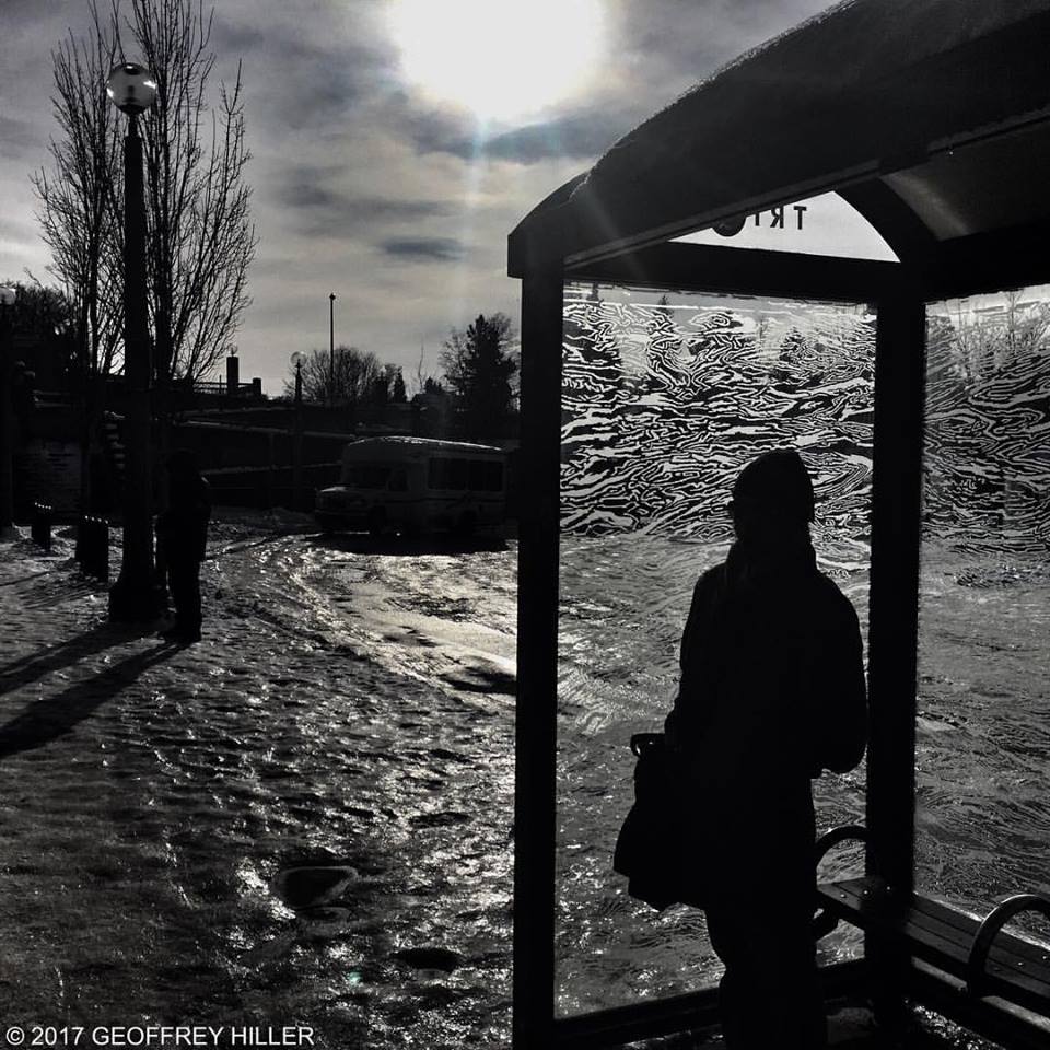
Part of Geoffrey Hiller’s exceptional series on Portland’s bus line 75.
Part of Geoffrey Hiller’s exceptional series on Portland’s bus line 75.
Among the cool things that Portland’s transit agency Tri-Met did during our record snowstorm is this:
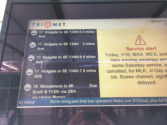
Instead of telling us a prediction of when the bus will arrive, they told us the fact of how far away it is. Predictions are not facts.
Free and conscious citizens should always value facts over predictions. It doesn’t hurt to have both, but predictions without facts can be dangerous. Humans always want more certainty about the future than the universe provides, so they tend to overvalue predictions, and even treat them as promises.
A rare citywide disruption puts all this in perspective, by highlighting something that is really always true. The transit agency is in no position to promise when the bus will arrive. Too many things out of their control might happen. What they can do is tell you the facts and let you make your own judgment about what to do.
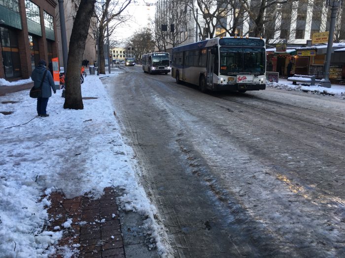
Portland’s transit mall five days after the snow fell.
Portland’s epic snowstorm continues. Five days after we got about 9 inches (30 cm) of snow, most streets are still coated with ice. Again, this shouldn’t be judged by the standards of snowier cities; this kind of extended storm happens less than once a decade here.
In my last post I talked about my transit experience on the first day, when snow was still coming down hard. Later that day, and twice the next day, I used Lyft– but since most Portland drivers work for both Uber and Lyft, I’m guessing an Uber experience would have been identical.
My three Lyft rides gave me five interesting data points:
How am I to “rate your driver” in some these cases? The Ghanaian guy gets 5 stars of course, but what of the other two?
Should I give a low grade to the a driver whose car is unsuited to these conditions, at least in the hilly part of town? Obviously this is mostly a policy failure, but should I declare, from my perch of authority, that he should have had chains?
What about the driver who didn’t have a left rear view mirror? Well, that’s plainly illegal and unsafe, but as I talked with him, I wondered if he could afford to not drive until he can get it fixed. As it was, he was also the tailgater, so it was easy to rate him low, but what if he’d been a great driver otherwise?
As I think about this, and about how the “rate your driver” scores are processed, I realize that I pretty much have to give 5 stars for anything other than obvious rudeness (unexplainable by cultural difference) or reckless driving. That’s because I can sense how much pressure these people are under, how few options they have, and how devastating even a 4-star rating can be. For all I know, someone’s kids are going to starve if I tell a guy to quit driving until his mirror is fixed. On the other hand, for all I know, he’s doing fine and is just risking his life and that of his passengers because he’s greedy.
Once you open that window into considering the real causes of problems, and the real impacts of ratings, it’s hard to close it.
This is an instance of a more general problem with all of the “how did we do?” surveys that fill my inbox every day. They really want my opinion of front-line staff, but often I can see that my negative experience was a matter of management. The obvious example is restaurant or hotel staff who are harried and unresponsive because the management has decided to have too few people on duty. I’ve learned to be careful about this. Unless I’m sure that the frontline person was entirely responsible for the outcome, the worst situations get five stars, plus maybe a little note that nobody will read.
Enough snow to almost paralyze Portland. Readers in Canada, Russia, and Scandinavia are invited to keep their comments to themselves. 🙂
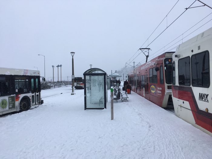
Portland’s Gateway Transit Center at 8:30 AM on January 11, 2017. Everything working fine, considering. Rail moved at 4x the speed of an adjacent freeway studded with abandoned cars.
Portland woke up to about 9 inches (23 cm) of snow yesterday, with snow continuing to fall, and I had a chance to watch a bit of the transport situation.
Unfortunately, that morning I was booked to fly out to a client visit in Southern Oregon, so I had to do the ritual of going to the airport so that I would be there in the unlikely event our flight wasn’t canceled at the last minute. When I checked my options at 8 am, with snow still coming down hard, Lyft was nonexistent, Uber had a 20+ minute wait with 2.5x normal pricing, but a bus was coming soon. I had a small adventure carrying a heavy suitcase through snowdrifts, but once on the bus everything was fine. The driver even had to stop for a minute because he was running early. Drop-down chains are great!
I connected to light rail, and because of snow operations I had to connect again within the light rail system, but it all worked fine. Each station I visited had a friendly transit employee with a snow-shovel. I got to the airport in about 1.2 times the usual travel time, faster than would have been possible by any other mode of transport. By then, many freeways were partly blocked by abandoned cars, including some especially dimwitted truck drivers who thought they could get over our highest bridge without chains.
It was funny to hear some people grumbling, as though the snow were the transit agency’s fault or their staff weren’t obviously doing their best. Remember, everyone who’s at work at 7 am in a snowstorm somehow got out of their houses at 4-5 AM. Levels of heroism should not be underestimated. Our agency, TriMet, did an amazing job. So, as you must do when you see staff working heroically, I sent a tweet:
Epic snowstorm in Portland. No @lyft. Very few @uber at 2.5x price. Driving very treacherous. Most transit is running fine!. Go, @trimet ! pic.twitter.com/It2OtasQwM
— Jarrett Walker (@humantransit) January 11, 2017
Of course, it was not so easy for everyone. The transit agency had pre-designed “snow routes” for buses that avoided most steep hills. (If you live on a hill, this is a “feature” of your location choice!) Trees were an issue; some trees bowing under the snow touched the catenary of the light rail and streetcar downtown, shutting them down for a while. “Only so many arborists,” @pdxstreetcar tweeted sensibly. (Another city might cut down trees that presented this risk, but you just don’t do that in Portland.)
So we got what you expect. We had made some local value judgments (not cutting down trees) that reflected our values but caused some trouble yesterday. Most people accepted that consequence of their values. And the transit agency staff really were amazing. In situations like this, I make a point of thanking every transit or city employee that I meet. On a snowy morning, a good greeting is: “Hey, I realize you got out here at 5 AM, and I really appreciate it.” Adjust to taste, but don’t say nothing. And as studies of gratitude have shown, this will actually help you feel better about your own inconveniences.
Finally, do not use the words “apocalypse” and “armaggedon.” Your parents and grandparents got through snowstorms without needing those words, so they mark you as a hysterical kid. Those words should be reserved for nuclear war, the Rapture, climate-induced civilizational collapse, and snow for those thin-skinned drama-queens in Seattle.
My last three New Years Resolution posts are all as relevant as ever at this vertiginous moment in history.
Since I apparently do resolutions only in even numbered years, I will let these stand as what I can offer for 2017. Again, we do longevity here.
Normally, one does a list of the most-read posts of the last year.
But I’ve always tried to write things that would be useful for years, so I’d rather show you the posts that were viewed most often in 2016. I’m delighted that only four of these were written in 2016:
Remember, this blog is full of old stuff that’s still relevant, notably the “basics” or “explainer” pieces. For links to all of those, see here! This year should remind us all that just because it’s hot off the presses today doesn’t mean it’s either useful or true!
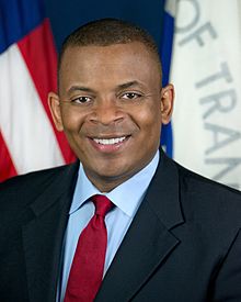
US Secretary of Transportation Anthony Foxx will deserve a special place in the history of US transportation policy. It has been a long time since the nation’s transport policy leader has reframed the conversation so profoundly. An interview of him in Citylab by Laura Bliss, dubbing him “The Great Connector,” draws out several of these themes:
 Building Communities, Enabling Contact
We might not always acknowledge it, but the reality is, when we build infrastructure we’re also building communities. It’s different than housing. It’s where boundaries are drawn, where highways and rail lines cut through, where transit stops are or the places that are skipped over. All of those decisions matter, because they all affect how we come into contact with each other.
This is a truism in urbanist circles but I’ve never heard it so forcefully from a Secretary of Transportation. In a department where handing out infrastructure money is the primary source of power, Foxx reframed the whole task away from the usual cost/benefit conversations or the love of technologies, to focus instead on the fundamental purpose of transport: how we “come into contact with each other” and thus, among other things, build communities. The acknowledgment of the “dividing” effect of some infrastructure is especially historic. Freeways enabled some connections only by obstructing others, like your ability to walk to a grocery store on the other side or the ability of a bus route to trace a straight path.
Shifting power downward from the Federal government to states and cities used to be a conservative “small government” idea, but no longer. The first step is to impose fewer Federal limits on how money is to be spent.
I’ve the made case—and will continue to make the case in my next life—that we need a more flexible funding approach. Rather than say that a certain percentage has to go to roads or transit or what have you, let the communities decide how that money should be spent, and grade them on criteria that shows how they’ve improved the system.
He’s especially clear that people who know the local issues need to make the decisions about them:
Regions and cities and towns could use more direct federal funds as well. This harkens back to my mayor days. Those areas can get things done relatively quickly, and many times they have a different sense of what they need than a state might. Rather than having regions, towns, and cities arguing over money, there should be a more dedicated program.
This is especially important for cities, whose needs are different from those of other areas but who often lack the autonomy to solve their own problems. We are entering an era where urbanist impatience with a controlling and dictating Federal government will be as great as that of conservatives has always been, and for similar reasons. If the next Administration is as hostile to urban issues (or perhaps, hostile to urban interests other than elite real estate development) we may soon reach a point where devolution of power is the only thing the nation can agree on. Cities will have to take care of themselves, and have the power to do so. Even some urban real estate tycoons may see the value of that.
Finally, in an age of division, he captures the singular role of transit in holding together urban civilization, using one of my favorite images:
Transportation can bring us together. When I ride on the New York City subway system, I’m riding with millionaires and with homeless people. No one is hidden from the other. That interaction doesn’t mean people live in the same neighborhoods, or that they go to the same school. But what it does mean is that no one is invisible.
Everything about politics today is about visibility. Are you forced to see the consequences of your own ideas? It is the genius of the city that almost everyone must, because they happen in front of you on the street, not just on television or the internet. My own city, Portland, is in a time of general prosperity, but it just had a mayoral election where the predominant issues were homelessness and affordability. That happened because those issues aren’t invisible in a city, the way they can be in suburbs or country towns. The genius of the city is that the billionaire, whatever his achievements, must still acknowledge that he shares a city with homeless people, whose condition may result from the same forces that created his. Transit keeps that reality present through the act of transportation. That’s not its purpose; no social engineering is involved. But the fact remains that in cities we must use space efficiently, and that often requires traveling in each other’s presence, so that we see the totality of what our city is.
Foxx’s reign has also included significant achievements in planning for automation, and he hints that they may still do something about the intrusiveness and harrowing potential of drones. Good stuff. But these shifts in tone may matter as much as anything. Good job, Secretary, and I hope you continue to influence the transport conversation.
Learn this term now: tactical transit.
(I wish I’d invented it, but the cool peeps at TransitCenter did, in their great overview today.)
If you know what tactical urbanism is, tactical transit is the same principle applied to transit. So it means something like this: Don’t just fight for giant infrastructure projects that take many years to fund, approve, and complete. Try things now, with what you have, in ways that (a) make a measurable improvement and/or (b) inspire people to see what’s possible. And often: Use temporary materials, as appropriate, to present things as experiments, so people can experience them before passing judgment on them.
The TransitCenter folks are thinking about street infrastructure when they use the term. Tactical urbanism creates parks, paths, and other infrastructure experimentally, using temporary and removable materials like planter boxes and folding chairs.
Temporary bulbout in Brooklyn, NY. Source: TransitCenter
Tactical transit does the same for bus stops, bus lanes, and other simple facilities. Street-running Bus Rapid Transit, after all, doesn’t have to start as a huge infrastructure project with years of delay for environmental review. A city can make bus lanes and stops quickly, with paint, signs, curbs, and other simple things, along with law enforcement.
Tactically Temporary Transit
Experimental transit infrastructure is an especially powerful technique because local interest groups along a street tend to wildly overestimate the impact these projects will have on traffic, parking, and local retail. Huge, irreversible infrastructure projects are more likely to trigger emotional reactions, in part because they are polarizing, like any binary choice. Your only options are support or oppose, and as we all know, that pushes lots of people to oppose.
Obviously, tactical transit is a very useful new term, but not a new idea. Transit facilities have been part of tactical urbanism for a while, and we even did it now and then back in the dark ages before we had words for it.
Construction projects have long presented opportunities for tactical transit. When you’re going to experience a sudden loss in road capacity because of a construction project, temporary bus lanes often make sense. Sometimes, when the project’s done, people don’t want these temporary lanes removed.
Permanent Tactical Transit?
Of course, the term “tactical” doesn’t have to imply temporary. Lasting permanent change is usually the goal of tactical transit. Presenting the change as experimental or temporary is a tactic — not just a political tactic but also a practical one. Some changes really don’t work, or need a lot of tweaking, so doing them temporarily, where that’s realistic, can be a great way to make sure we get them right. Anyone who’s encountered expensive but poorly planned infrastructure can see why this is a good thing.
We can extend the term further. An effective frequent bus network is tactical, compared to a giant infrastructure project, because its costs are diffuse and it can be tweaked after implementation. But as always, great tactics serve a strategic purpose. All the network redesigns I’ve done are parts of strategies, with clear goals for permanent transformation. Tactical transit should not mean quick fixes for some urgent problem without regard to long-term results. Such fixes are sometimes necessary, but smart strategy, manifested through smart tactics, is always playing a longer game.
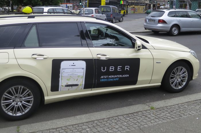
Photo: Alper Çuğun, via Flickr
This post pulls together everything I’ve had to say on the subject of how ride-sourcing companies like Uber could impact cities. I hope to leave this topic for a while!
Henry Grabar at Slate has a good piece on an issue that I have been raising the alarm about for a while.
The rise of ride-hailing companies is increasingly viewed not as a fix for bad service but as its justification. It is invoked, as you might expect, in bad faith by [people] who have advocated against public investment for decades. But even pro-transit politicians and officials have begun to see ride-hailing services as an acceptable substitute for public transit. As a result, cities across the country are making important decisions about transportation that treat 10-year-old companies as fixed variables for the decades to come.
Regardless of their corporate intentions, Uber and its ilk are doing harm to transit — and thus to transit-reliant dense cities — in two ways: one in the politics, the other in the reality of competition on the ground.
These two strands converge in the geometry problem that is at the core of urbanist alarm: If travelers shift from larger vehicles (like buses) into smaller ones (like Ubers) you increase Vehicle Miles Travelled, which increases congestion, emissions, and the demand for road space. This is tolerable in low-density areas but an existential threat to dense cities. None of these would be problems if the higher cost of smaller-vehicle services reflected the true cost of their inefficient use of space. But as we know, cars’ inefficient use of urban space is rarely reflected in the cost of urban driving, and Uber skates through on the same invisible subsidy that all urban motorists enjoy. Transit, which doesn’t enjoy any such subsidy, is unable to properly reflect its efficient use of space in its pricing.
I’m sure that someone’s going to say that “Uber isn’t trying to damage transit.” That’s not a response to any of these issues, because the issue is not intent but outcomes. Uber’s behavior often looks like an intentional effort to undermine competitors and thus reduce customer choice — in which case you’d call it predatory pricing — but it doesn’t matter what the intention is. Underpricing is a blunt weapon with zero targeting ability. It mows down everything in its path.
Obviously, Uber is doing what all companies do, including trying to limit competition. There’s no point in criticizing them in particular for that. Such a critique would have to be leveled at all the underlying assumptions of American capitalism.
And there’s no doubting the value of these companies in the lives of fortunate people who can afford to use their services routinely, or that they have positive roles to play in parts of the urban transportation picture, such as low-demand areas.
But it’s time to quit discussing Uber and similar companies as though they were improving the world in a permanent way, and as though they will necessarily make cities better for everyone. We already know that’s not true. Governments need to regulate to expand the opportunities these companies, but must also respond to threats that they pose.
All this can be done very politely, by the way. Many people who work inside of big companies understand perfectly well how the profit motive conflicts with what you’d do if you were just trying to foster a better city, and many welcome regulation precisely to plug that gap.

Updated 23 Dec 2016 with concept maps and link to Next City article.
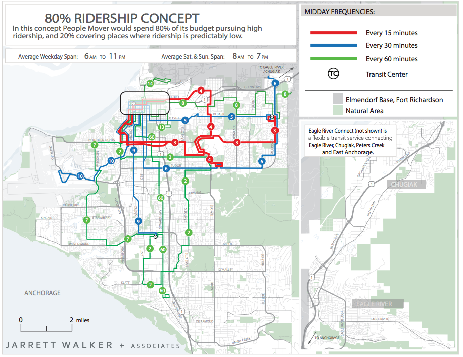
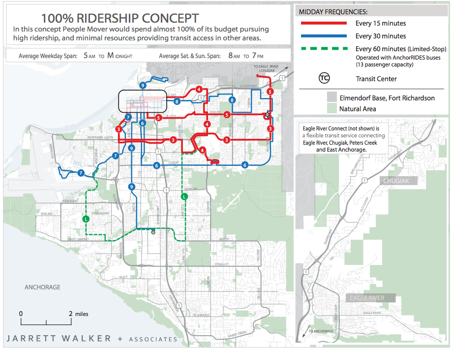
Our firm’s work for the Alaska’s largest city has turned into a public conversation about two possible futures for the transit network. As often, the choice is the ridership-coverage trade-off: Should the transit agency try to go everywhere with mediocre service, or should it focus on the places where high ridership is possible, and run good service there?
The city’s online presentation is very thorough. You can explore the two concepts in detail, but you can also look at isochrones showing how your ability to get places changes under each scenario. It’s the process we recommend for many studies at this point, since it turns the conversation away from proposals — with their tendency to polarize people into “support” and “oppose” camps — and focus instead of alternatives that each have advantages and disadvantages.
Here are the two alternative concepts. Remember, these are not yes/no alternatives. They are points on a spectrum and the final decision may be anywhere along that spectrum.
The Alaska Dispatch-News has a story on the process (though it inaccurately calls the concepts “proposals”). For a really fun read, have a look at this unsigned opinion piece in the Anchorage Press. The writer captures the special frustration of having lots of bus routes to choose from, none of which may actually be coming:
Between downtown and [University of Alaska], I’m spoiled with five options. When I miss the 3, a direct connector, I know the frequent [but circuitous] 45 won’t be long. If I’m really lucky, I’ll catch the 102, truly the unicorn of Anchorage bus routes (operating pretty much never, this rare but beautiful beast boomerangs through downtown on a route where red lights are rare and left turns are rarer). The far-flung 36 is obviously not my option, as it hugs Turnagain/West Anchorage, but the 13 seems blissfully benign, a loping zigzag across the city.
Often, when I’ve missed the 3 in the dead of winter, the 13 beckons with its bright lights twinkling “Downtown.” I know it’s a mistake, but it’s cold and I can’t help but climb aboard. Like traversing the doldrums, there’s no wind in the sails but at least it’s warm. So I steer into the Bermuda Triangle of bus routes, hoping to someday make it home.
It gives quite an attentive tour of Route 13, Anchorage’s most circuitous bus route. Here’s the map if want to follow along.
Update: Jen Kinney at Next City has a good piece on the plan.