Esta página está disponible en español aquí.
Our latest work on the Miami-Dade transit network is now available online, and we’re looking for people from the area to provide their input through this online survey.
The well-respected advocacy group, Transit Alliance, is leading the Better Bus Project on behalf of both Miami-Dade Transit and several of the key cities. Transit Alliance and the County hired us this year to help develop transit network alternatives that would illustrate what the transit network could look like if the trolley networks were more coherently integrated with the overall county-wide network and if the balance between ridership and coverage goals were changed.
The local newspaper, the Miami Herald, has a good article about the networks and the choices they illustrate.
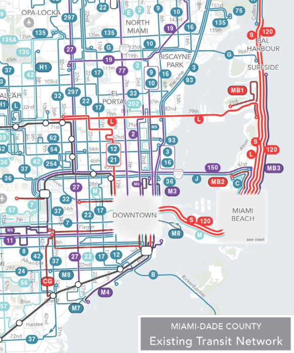
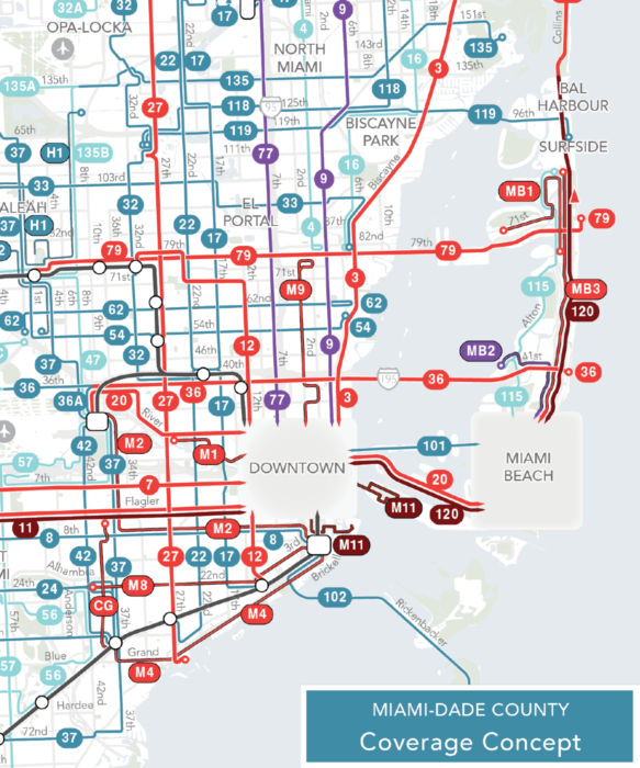
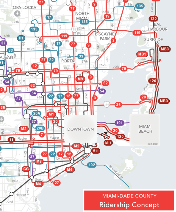
We previously released a Choices Report that highlighted one of the major shortcomings of the existing network, a lack of a frequent grid. The two network concepts we developed try to build a frequent grid, at least in the core of the network. Below are slices of the Existing Network, Coverage Concept, and Ridership Concept for the core of the region.
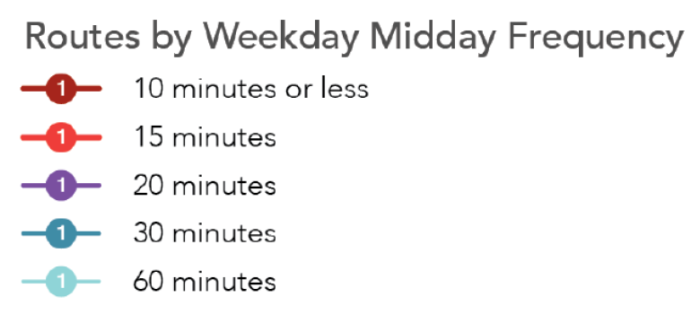
And the legend:

The concepts cost the same as the existing network, and they are fully implementable. If everyone loved one of the concepts, it would be possible for Miami-Dade and the cities to make the network changes and implement one of these in 6-9 months. But we aren’t asking people to pick one or the other. We’re asking people to tell us which concept they are closest to, so that the County Board and City Commissions can get input on the direction they should choose for Miami-Dade.
Some other key questions raised by these concepts include:
- Should the trolleys be changed to make them complementary parts of a county-wide network? Both the Coverage and Ridership Concepts can provide more frequency on more streets because the city and county networks are designed to complement each other.
- Should bus stops be placed farther apart so buses can go faster and people can get where they are going faster. Today, stops are about 1/8 of a mile apart. Both the Coverage and Ridership Concepts assume that stops are spaced about ¼ mile.
- And, of course, how should the region balance the competing goals of ridership and coverage?
So if you know anyone in Miami-Dade County, send them to the project website to explore and express their views. Encourage them to peruse the Concepts Report. And if you’re interested in reforming bus networks in general, watch the conversations around the concepts and the ultimate decisions by the local elected leaders. As with every network redesign we do, these concepts are here to help people decide what values they want transit to prioritize. We can help the community understand the options and the outcome, but it’s ultimately their decision.


Wow you really hate Key Biscayne
It’s a little weird that coverage doesn’t improve over the existing network even in the ‘coverage optimising’ case. If I lived in Miami and valued coverage, I think I might feel that this change was a one-way-choice towards improving ridership. It feels like the lower left of the triangle should’ve been more to the left than the current case.
Because the coverage concept still needs to realize some improved ridership.
Just a general question regarding the frequency/journey time ratio.
Assuming you had a typical small town to city centre route with other variables (bus, fares etc) even. To the average prospective passenger, which is more attractive: a 60 minute frequency / 30 minute journey time or 30 minute frequency / 45 minute journey time? Reason I ask is that there are a couple of local operators in my area of the UK who seem to think that having a slower bus leaving at, say, xx00 being caught up by one which left at xx20 is preferable to having the faster bus leave at, say, xx45 so that the buses are spaced more evenly on arrival.
A 60 minute frequency / 30 minute journey time and a 30 minute frequency / 45 minute journey time are probably both about equally attractive. This is however irrelevant for your UK example. If the xx00 bus are 20 minutes slower than the xx20 bus, then the xx00 bus is useless for your case. It would definitely be better to have the fast bus leaving at xx45 instead (one slow and one fast bus per hour is of course better than only one fast bus!).
In cases where there is one fast bus and one slow bus, the optimal scheduling for passengers is to have equally even intervals both at arrival and at departure (this can be proven mathematically). Let’s say that the slow bus takes 60 minutes and the fast bus takes 40 minutes. If the slow bus leaves at xx00 and arrives at xx00 the next hour, then the fast bus should leave at xx40 and arrive at xx20. This means that you have equally even 20/40 frequency both at departure and at arrival. Some of the exceptions to this are if the speed difference is greater than the interval between buses, then the slow bus does not matter at all, and if buses goes very often so that passengers arrive at random to the stop, then passengers tend to prefer riding on the bus before waiting at the stop, so frequency should be more even at departure than at arrival (but in these cases it’s probably more important to concentrate on getting equal loading to reduce crowding)
Unfortunately, all of this is to complicated to most public transport planners. Also, in my experience, UK does not have the best competency for planning timetables for public transport. However the problem in your specific area can definitely have many other reasons, for example coordination with other routes or that the better scheduling would require more vehicles.
Thanks for the reply, my guess is they are interworking routes to comply with drivers hours legislation, but why they need to put an additional bus into the cycle to give a roughly half hour layover each hour rather than swap drivers I have no idea.
As I understand it a European style pulse network would see the routes mirrored on the clock face with a 3 minute transfer window xx57 to xx00, so the 45 minute route would depart at xx06 and arrive xx51 in both directions but I’m not sure what they’d do with the 30 minute route in this instance!
When designing the ridership/coverage networks, do you have to do any tricks to make sure that crosstown service isn’t neglected?
At first glance, one would expect the ridership network to cannibalize service on the crosstown routes to run more frequency on the radial routes (those going into/out of downtown), while the coverage network would cannibalize crosstown service in the inner part of the city (since they still have radial service) to fund more buses out in the hinterlands.
I’m asking this because one commonly-overlooked fact is that, for getting around a city easily without a car, you need not just frequent transit, but transit running in all directions. Having buses that run north/south every 5 minutes is great, but if you still need a car to go east/west, then you still effectively have to own one. Once you’re already paying all the fixed costs of car ownership, you may as well just drive the car north/south too, as long as the parking is free, and the gas is cheaper than the bus fare.
In some ways, crosstown bus service feels like the ugly stepchild. It doesn’t have quite enough ridership to qualify for “ridership service”, yet it doesn’t provide the only service to any neighborhood, so it doesn’t qualify for “coverage service” either. Yet, it’s still vitally important to a functional transit system.
That said, in your Miami map, does appear to be at least ok crosstown service in much of the city, and the ridership network even has some crosstown routes marked as “frequent”. I’m curious how crosstown service gets justified by the ridership/coverage goals in the real world.
Ridership networks maximize the number of places where frequent routes cross, because that’s how you maximize where people can get to. As a result, they usually feature high frequency crosstown services perpendicular to downtown-oriented services.
What happens when the rising sea levels flood Miami? Plans are only for the 1st half of the 21st century.
Build a sea wall just like the Dutch did.
Or redesign the bus network to take the newly expanded ocean into account. It’s not as if a bus network should even last 50 years.
Miami is built on top of porous limestone and sand. A sea wall will be nice to stand on, but there will be water on both sides. https://sealevelrise.org/states/florida/
In the meantime, people need better transit to get around and bus networks can be redesigned.
Many of the roads will be raised by a few feet. Many of the houses will be replaced by new ones.
It will be expensive, but South Florida is one of the wealthiest metropolitan areas in the world, it can afford it.
A lot of the development nowadays is focused on skyscrapers along the coast, which is a very environmentally friendly format and will make Miami increasingly sustainable in the future, more so than most US cities.
This looks great. I’d like to see 10 minute headways on a route between Downtown Miami and Miami Beach, though. High frequency routes are also important between Brickell, Downtown, Wynwood and Midtown. It’s hard to tell from the map, but it looks like the ridership concept connects all of these neighborhoods with 15 minute headway routes.
Route consolidation/elimination isn’t as dramatic as some other redesigns, but this is probably a function of the grid network and Miami’s unique urban geography. Good work all around though.
Both the Ridership and Coverage Concepts have a Route 120 from Downtown Miami to Miami Beach that runs every 7-8 minutes. There is a 10 minute routes connecting the Downtown Miami and Brickell areas in the Ridership Concept. You can get more detail on the frequency of each route in detail in the full Concepts Report.