Miami

Miami: El “Better Bus Network” (La mejor red de autobuses) ya se implementó


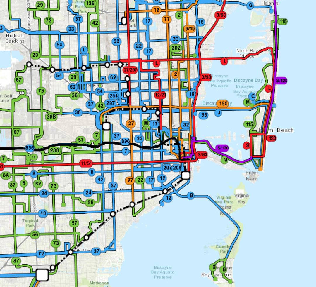
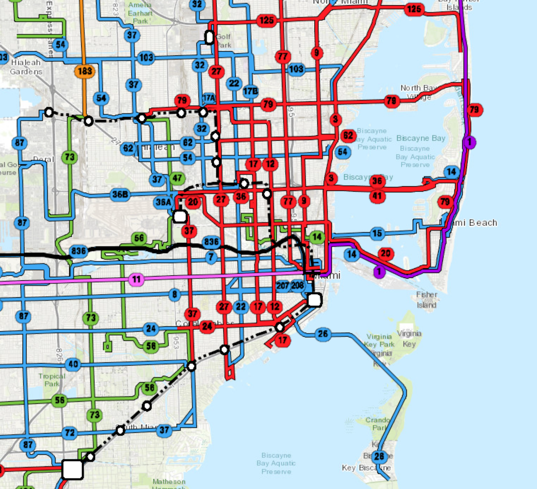
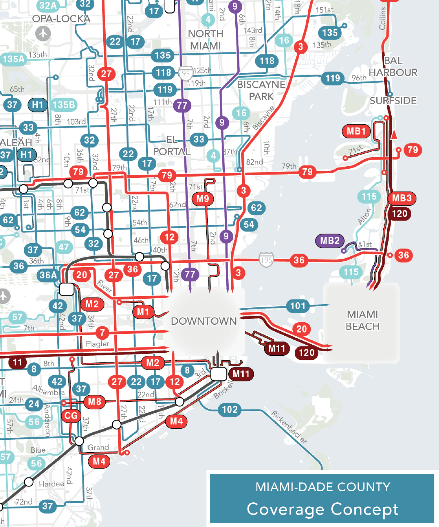
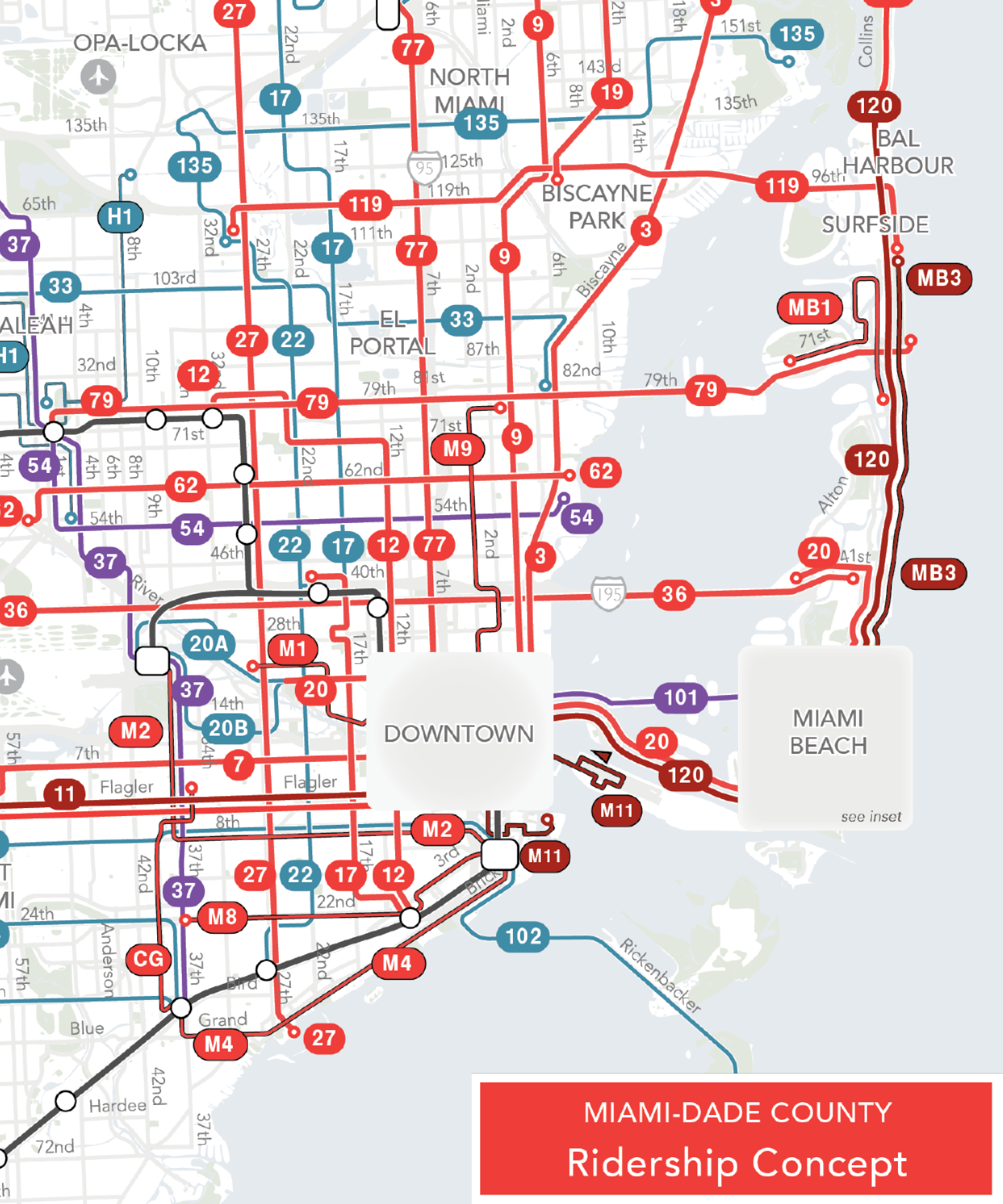
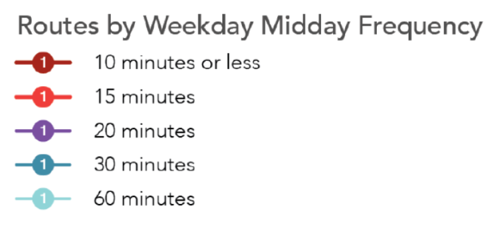
Una rebanada de la nueva red.  Consulte el enlace abajo para ver todo el mapa.


[Read in English here.]

El 13 de noviembre, Miami-Dade tuvo la transformación más grande desde que Metrorail empezó hace casi 40 años. No fue una nueva línea de tren, sino un rediseño enorme del sistema de autobús que hace que el servicio sea más útil para más personas y más viajes en todo el condado.

Los autobuses de Miami-Dade operaban en patrones que se habían mantenido iguales por décadas, incluso con el crecimiento del condado y más destinos importantes construidos. Es difícil cambiar el servicio de autobús porque incluso las rutas más ineficientes tienen personas que dependen de ellas y se oponen a cualquier cambio. Por lo tanto, para rediseñar un sistema de autobús, tenemos que mostrar grandes beneficios para que valga la pena. Eso es lo que hace este rediseño.

Nosotros (Jarrett Walker + Associates) ayudamos a liderar conversaciones sobre el Better Bus Network desde nuestro trabajo con Transit Alliance y el Condado de Miami-Dade en el 2019. Llevamos a cabo una conversación alrededor de preguntas claves, conceptos para mostrar lo que significaría enfocarnos en diferentes metas y desarrollamos un Plan Borrador en el 2020. El Plan estaba en el proceso final de participación ciudadana cuando Covid descarriló casi toda la industria del transporte público.

Desde el 2020, el condado siguió trabajando para terminar el plan y publicó el Plan Final en el 2021, con 30% más servicio. Desafortunadamente, la industria del transporte público tuvo problemas con falta de choferes justo después de Covid y el plan se tuvo que reajustar con menos choferes de lo que se habían imaginado. Incluso con los cambios, el nuevo plan sigue ofreciendo excelentes resultados para grandes partes del condado, sus residentes, trabajadores y visitantes.

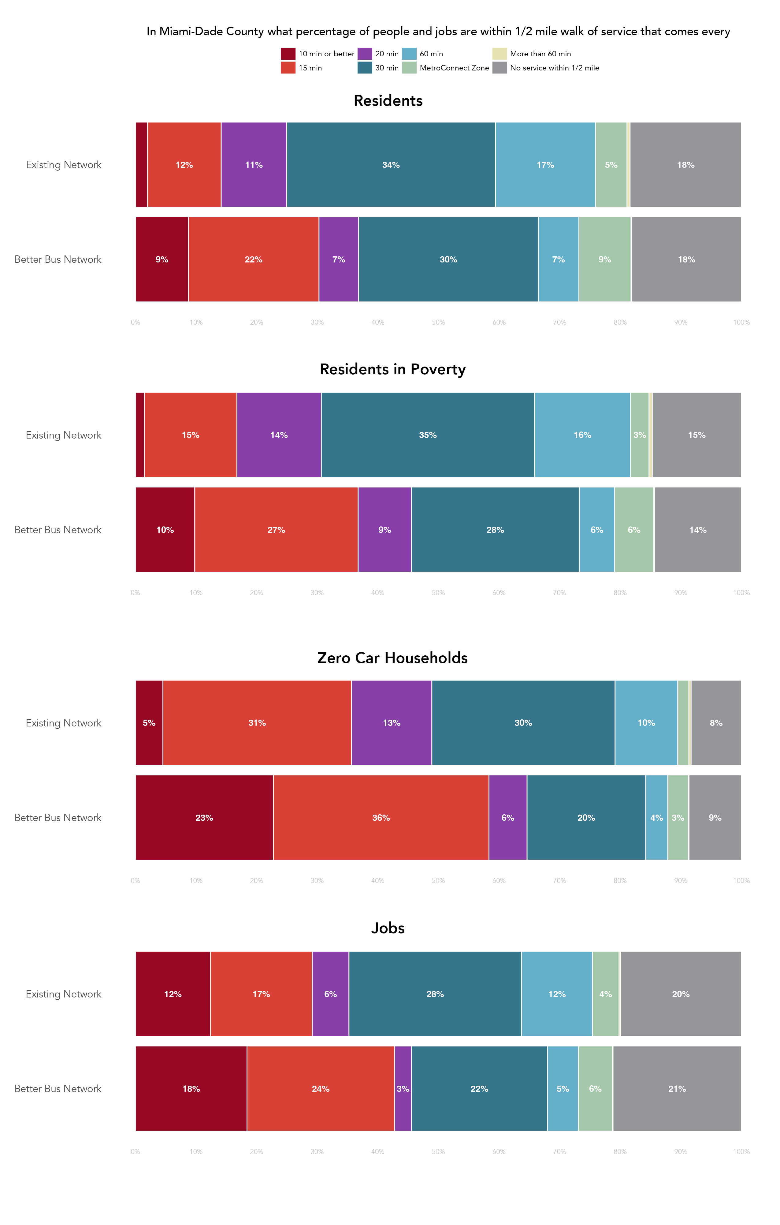
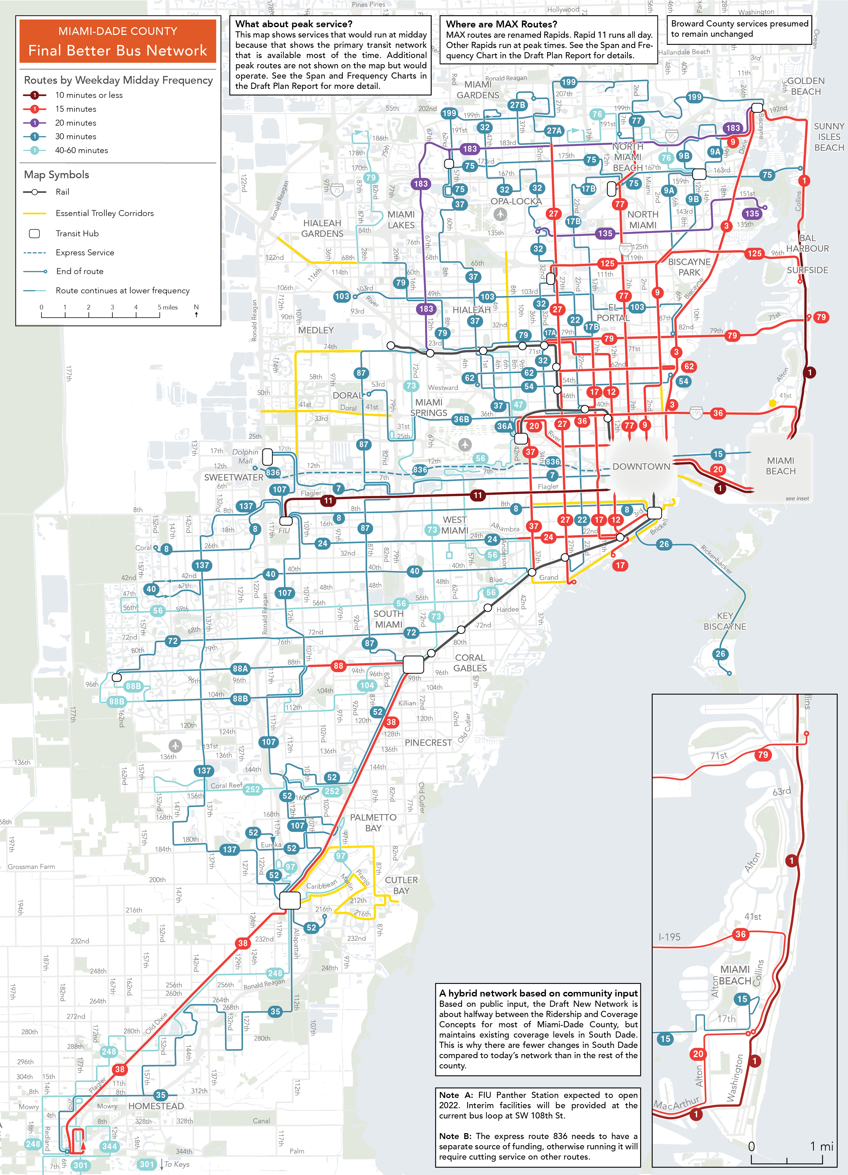
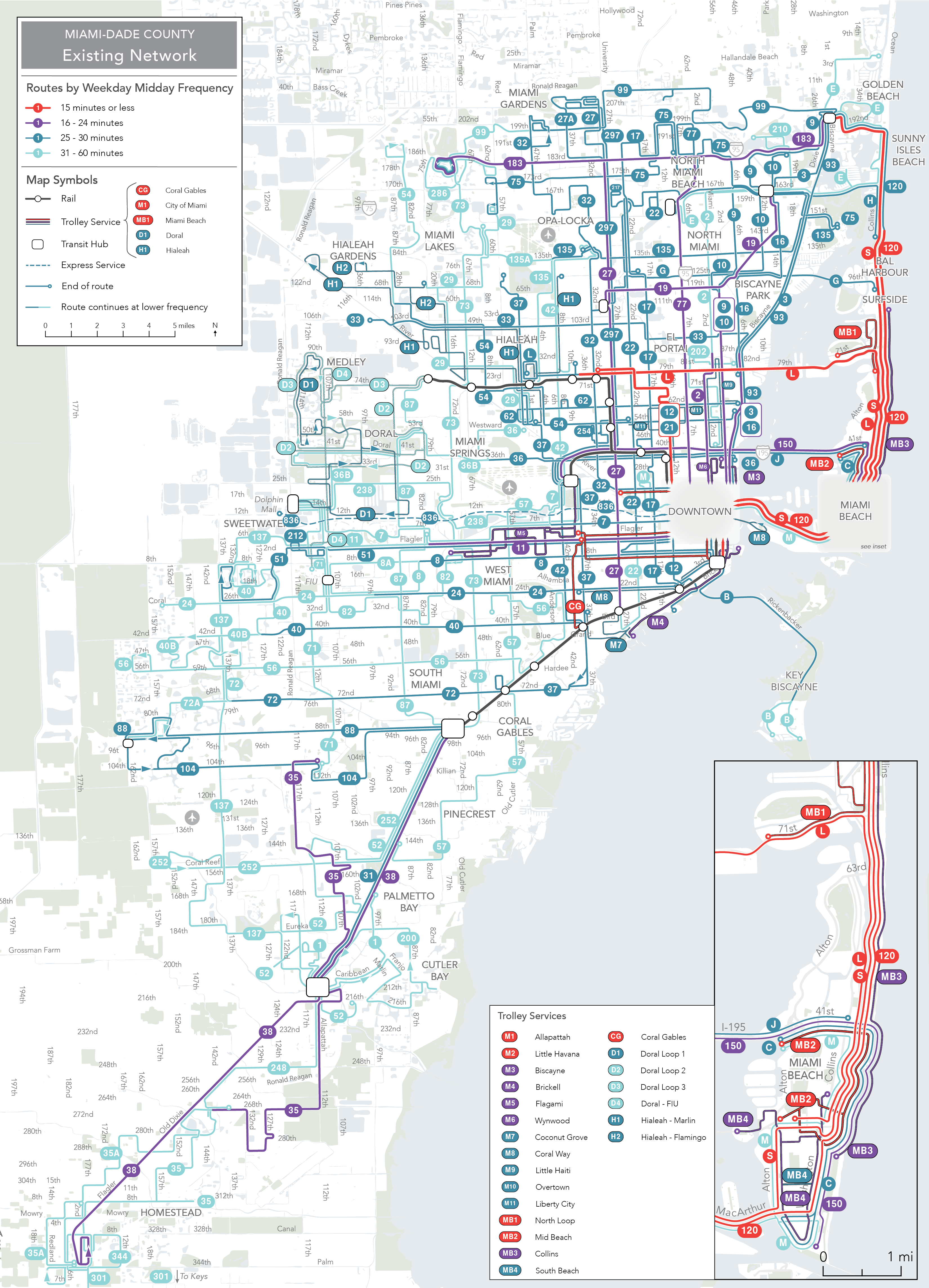
Con el nuevo rediseño, una nueva cuadrícula de rutas frecuentes cubre grandes partes del condado y provee grandes beneficios. El indicador más simple para medir estas mejoras es el número de personas y trabajos cerca del servicio de transporte público. La tabla a continuación muestra el cambio de residentes y trabajos cerca de servicio según la frecuencia del servicio al mediodía lunes a viernes. El número de residentes que viven cerca de servicio frecuente (cada 15 minutos) aumentó de 380,000 (14% de los residentes del Condado) a 814,000 (30%). El nuevo sistema provee servicio frecuente a cerca del 60% de hogares sin vehículo privado—eso corresponde a 20,000 más hogares sin vehículo privado que están cerca de servicio frecuente. Trabajos cerca de servicio frecuente aumentaron de 29% a 43%.


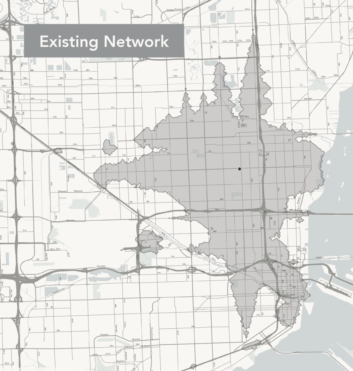
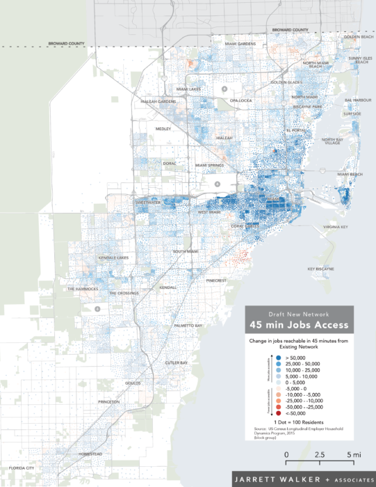
Una medida clave de cuan útil es el transporte público es el acceso que provee—a cuantos destinos puedes llegar dentro de un tiempo razonable. El siguiente mapa muestra un ejemplo de este cambio desde la Pequeña Haití.

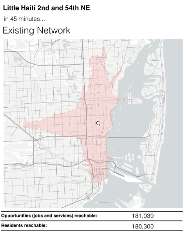
En rojo se muestra la zona que podías acceder con el Sistema Antiguo en 45 minutos. En azul se muestra la zona que puedes acceder con el Better Bus Network. La zona azul es más grande, pero más importante es que ahí hay más destinos: 30% más trabajos y 60% más residentes. Por lo tanto, si vives cerca de este lugar, eres 30% más libre. Si tienes un negocio aquí, ahora tienes acceso a 60% más clientes o 60% más trabajadores.

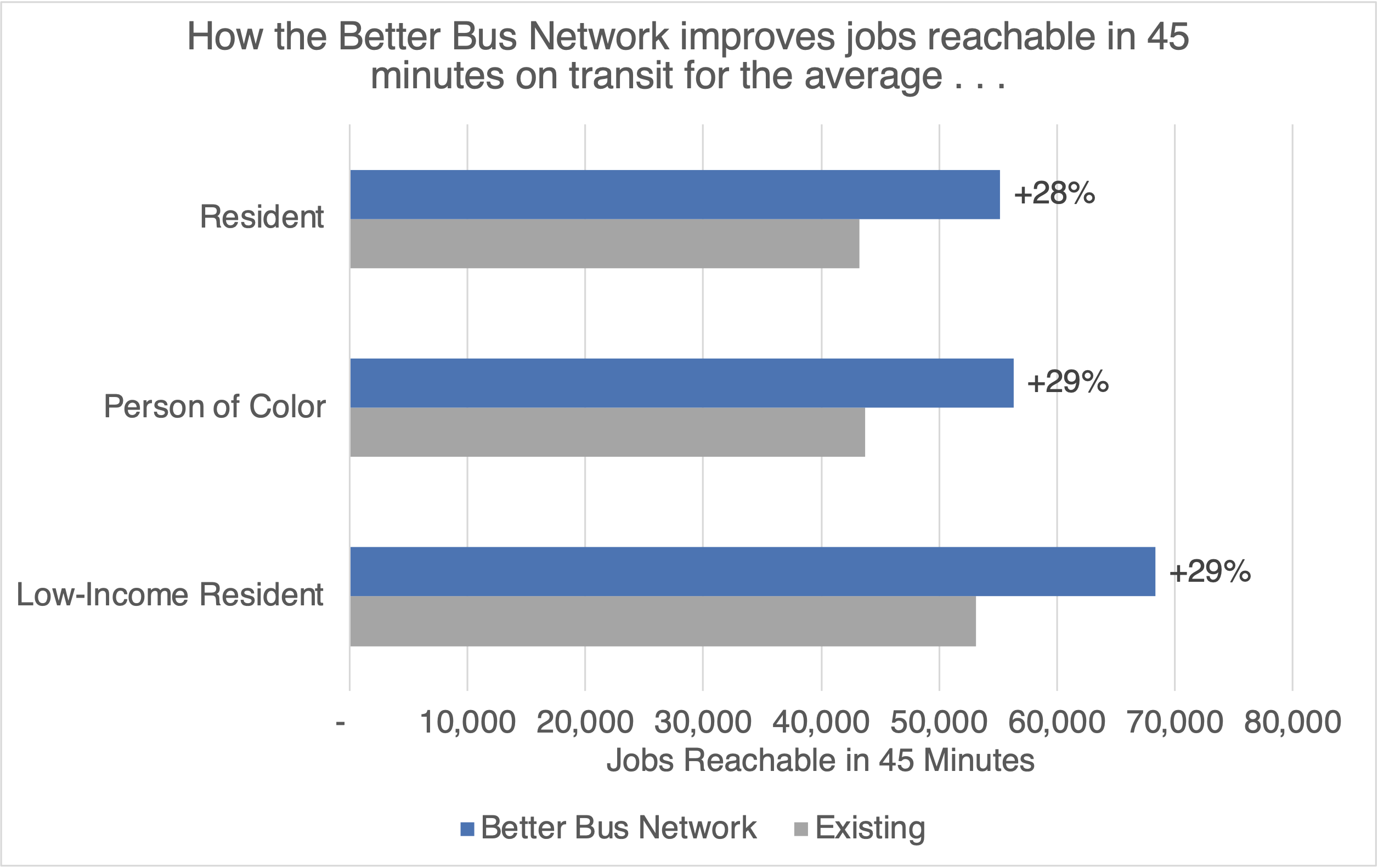
Podemos medir esto una y otra vez a través en todo el condado y si resumimos los resultados vemos que el residente promedio puede acceder a 28% más trabajos (u otros destinos útiles) en 45 minutos. Este beneficio es aún más grande para residentes de bajo ingreso y minorías. Esto significa que más personas al evaluar un posible viaje, encontrarán que el tiempo de viaje es razonable.

Para leer mas sobre esta medida, consulte aquí.

La otra mejora del nuevo sistema es el gran aumento en la frecuencia de servicio en los fines de semana. Hemos trabajado en planes alrededor de todo Estados Unidos que han aumentado el servicio durante las noches y los fines de semana y suelen ver aumentos en el uso del transporte público. La gente valora flexibilidad y espontaneidad. Todo el mundo quiere tener la habilidad de volver a su casa fuera de las horas laborales tradicionales, 8am a 5pm. Además, las horas pico tradicionales de ir al trabajo son menos importantes hoy ya que más gente trabaja remoto. Aún más importante, personas que trabajan en tiendas o restaurantes usualmente tienen que trabajar los fines de semana. Una ruta que no es frecuente en los fines de semana no está ofreciendo servicio adecuado para las horas pico de estas industrias. En Miami hay muchas, muchas personas que trabajan en estas industrias.

Implementando Grandes Cambios

Igual que en el Condado de Suffolk (Long Island en Nueva York), hemos estado colaborando con Miami-Dade Transit en la implementación. ¿Cómo se hace un cambio tan grande de un día para otro? Meses, a veces años, de planificación nos preparan para un día como este. Grandes partes de la planificación incluyen:

  • Coordinación entre los grupos de planificación, programación, comunicación y todo el gobierno del condado para preparar materiales claros de comunicación con el público.
  • Comunicación continua con oficiales públicos y municipios.
  • Planificación de Title VI, nuevas paradas de autobús, detalles de programación de rutas, preparación de horarios nuevos, mapas del sistema, y mucho más.
  • Ensayo de rutas nuevas, revisión de la ubicación de las paradas, trabajo con los choferes para que se aprendan las rutas nuevas, y mucho más
  • Contratación de empleados para orientar a los usuarios y explicar los cambios.

Un proyecto así requiere un esfuerzo enorme en equipo y los empleados del condado han trabajo mucho y por bastante tiempo para hacer que este día sea una realidad.

Transit Alliance ha seguido trabajando con el condado para comunicar los cambios del sistema al público y nos alegra poder colaborar en este proceso. Nuestro equipo contribuyó de varias maneras:

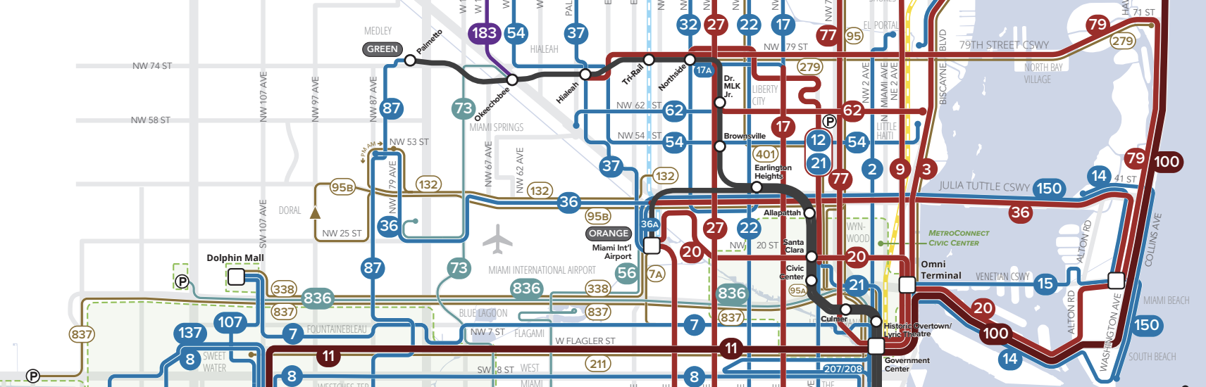
  • Creamos un nuevo mapa del sistema donde los colores de las rutas representan su frecuencia. Este mapa pronto estará en las paradas de autobús por todo el condado.
  • Desarrollamos una herramienta interactiva para ayudar a los usuarios a entender cómo pueden hacer sus viajes en el nuevo sistema.
  • Diseñamos los rótulos de paradas de autobús para informar a los usuarios sobre los cambios de rutas en cada parada.

Nos entusiasma ver cómo la gente responderá a este nuevo sistema y esperamos que genere un marco para muchas mejoras al transporte colectivo mientras el condado implementa el plan de largo-plazo (SMART) y otras inversiones en el sistema.


Miami: The Better Bus Network Is Here!


A slice of Miami-Dade’s Better Bus Network. See the link below for the full map.

On November 13, the greater Miami area will see the biggest transformation in where you can go on public transit since Metrorail opened almost 40 years ago.  Not a new rail line, but a huge redesign of the bus network that will make it useful to more people for more trips, all over the County.  A complete map of the new network is here.

Miami-Dade County’s buses run in patterns that have often been the same for decades, even as the county has grown and many new destinations have appeared.  It’s hard to change bus service, because even the most inefficient bus route has people who depend on it and will object to any changes.  So, to redesign a bus network, we have to show big benefits that make the change worth the trouble, and that’s what this redesign does.

The plan is the result of a planning project that begin in 2019.  In an unusual partnership, Transit Alliance Miami funded much of the work and hired us (Jarrett Walker + Associates) to lead the planning process in partnership with the County. We led a public conversation around key trade-offs, by sharing contrasting network design concepts that showed the consequences of different possible goals.  Based on the response to that process, we developed a Draft Plan in early 2020.  We were then rudely interrupted by Covid-19.

Since 2020, the County has worked to finish the plan and as published a revised plan, with 30% more service, in 2021. Unfortunately, the transit industry was hit by the labor shortages of the post-Covid era, and the plan had to be reworked to manage with a smaller workforce than previously imagined. Even with the changes, the final plan now being implemented still delivers great results for huge swaths of the county, its residents, workers, and visitors.

With the new design, a frequent grid will cover large parts of the county with huge benefits. The simplest measure of that improvement is how many people or jobs are near service. The chart below shows the change in residents or jobs near service by the frequency of service at midday on weekdays. The number of residents who live near frequent transit will increase from 380,000 (14 of the County’s residents%) to 814,000 (30%) during weekday service. The new network will bring frequent service near almost 60% of households without cars; that’s 20,000 additional households without cars near more frequent service. And jobs near frequent service will increase from 29% to 43% on weekdays.


A key measure of a network’s usefulness is the access it provides, or how much stuff you can reach in a reasonable travel time. The animated map below shows an example of this change from Little Haiti.

In pink is the area you can reach in the Existing Network in 45 minutes. In blue is the area you can reach with the Better Bus Network. The blue area is larger, but more importantly it has a lot more stuff in it: 30% more jobs and 60% more residents. So if you lived near this place, you would effectively be 30% more free. And if you owned a business here, you’d now have access to 60% more customers, or 60% more workers.

We can measure this exact thing over and over again across the whole county and when we summarize the results we find that the average resident will be able to get to 28% more jobs (or other useful destinations) in 45 minutes. The benefit is even greater for lower-income residents and people of color.  That means more people, when they look up a trip they might make, will find that the travel time is reasonable.  For more on why we use this measure, see here.

The other big improvement in this new network is a major increase in frequency of service on weekends. Across the country, we’ve worked on network plans that have increased service on evenings and weekends and they’ve often shown huge ridership gains. People value flexibility and spontaneity. Everyone wants the ability to get home outside of the traditional 8-to-5 workday. Critically, though, people working in retail or restaurant jobs often need to work on weekends. A route that runs infrequently on the weekends is missing the peak time for people in these industries, and there are many, many people in these industries in Miami-Dade.

Implementing Big Change

Our team has been working closely with Miami-Dade staff to assist with a range of implementation needs. How does a huge change like this happen overnight? Months, sometimes years, of planning leads up to a big day like this.  These efforts included:

  • Work by staff across County government to help people find out about the change, and can learn about it easily.
  • Briefings of elected officials including partners in the city governments.
  • An analysis of compliance with Title VI, the US Civil Rights law that ensures racial equity in transit planning.
  •  Siting of new bus stops and removing old stops.
  • Writing new schedules for customers and bus operators.
  • A big effort by operations and safety teams working on testing turns, reviewing stop locations, working with operators to learn new routes, and much more.
  • Finally, an infusion of temporary staff near the change date, to be out on the street helping people find their way.

It takes an enormous team effort and County staff have worked hard for a long-time to make this day happen. Transit Alliance has continued to partner with the county to help with communicating the network changes to the public and we’ve been please to assist in that process. Our team has contributed in a few key ways:

  • A new system map with routes color-coded by frequency. These maps will start showing up in shelters around the county soon.
  • An interactive trip comparison tool to help folks find out how they can make their trips on the new network.
  • Developing bus stop signage to inform riders at each stop about which routes are changing.

We’re excited to see how people respond to this new network and we hope it helps set the stage for many transit improvements to come as the County implements its long-term SMART plan.

Miami: A Revised New Network

Esta página está disponible en español aquí.

In 2019 and 2020, we collaborated with Transit Alliance Miami to help them develop a new bus network for all of Miami-Dade County. In April the Final Plan was published and put out for public comment by Miami-Dade Transit and their survey showed that 89% of people wanted to see the changes implemented!  In October 2021, the County Commission approved the plan for implementation.

This is what the existing network looks like:

Frequency coded public transit map excerpt from the existing network centered around Miami, Florida

Existing Network. Colors mean all-day frequency! Purple = 10 minutes or better. Red = 15. Orange = 20. Blue = 30. Green = 60.

And here is the revised network with fewer routes, less duplication, more frequency:

Frequency coded public transit map excerpt from the revised network centered around Miami, Florida

Revised Network. Colors mean all-day frequency! Purple = 10 minutes or better. Red = 15. Orange = 20. Blue = 30. Green = 60.

(This is not our mapping style, by the way.  It’s from a tool developed by Kittelson Associates that lets you move a slider back and forth between the two maps, so that you can see how different they are in the same place.  It can be a little clunky.  Look close for a vertical grey bar and you’ll find you can slide it left and right.  If it isn’t working, reload.)

The revisions to the Better Bus Network since April are relatively modest and include adding back some coverage routes in a few places, some extensions and improvements to service on the beach and a few other corridors. These changes are possible because the revised network provides more service than what we originally planned because the County is now proposing to invest in 7% more bus service than the pre-pandemic network!

As we’ve said before, the Better Bus Network as drawn last year wasn’t what Miami-Dade needed, it was what Miami-Dade could afford. It’s great to see political leaders at the County, led by Mayor Cava, willing to invest in more service to achieve better outcomes.

Miami: A New Network with a Resilience Plan

Español

For the past 18 months, we have been redesigning the bus network for Miami-Dade County, Florida with the local advocacy group Transit Alliance. As the final public engagement phase was coming to an end, the pandemic reached the United States, and like many other agencies, Miami-Dade Transit went into crisis management mode. So our work paused for about four months.

As the pandemic wore on, it became apparent that the agency needed more than a single transit network ready to implement.  It needed a plan that could adapt to a range of unpredictable futures. Nobody knows how long the pandemic will go on, or what affect it will have on tax revenues that the agency relies on.

So, in finalizing the Better Bus Network, we worked with county staff and Transit Alliance to develop a Resilience Plan, to guide future decisions about how to ramp service up or down in the face of an unknown future.

But first, let’s talk about how we got here.

In the first phase of the project, we developed a Choices Report to analyze the existing network and discuss key questions that determine how the network should be designed. We took input from the public about those questions and developed two concept networks that highlight the tradeoffs between focusing on coverage and focusing on ridership. We returned to the public to ask them which way they lean between these the two concepts. Remember that it’s never one or the other; the ridership and coverage concepts represent two ends of a spectrum. Based on public input, we designed a Draft Network that was halfway between the two Concepts and now we revised it into the Final Network.

Below are slices of the Existing Network and New Network for the core of the region (click the maps to see the full-size maps of both networks).

A comparison of the maps of the Existing Network and the Final Better Bus Network in Miami-Dade County, Florida. Note the line colors, which indicate midday frequency.

Click here for the full map of the Existing Network

Click here for the full map of the Final Better Bus Network


The New Network creates a frequent grid that helps residents get to more places sooner. In this network, 353,000 more residents are near a frequent route (an increase of 13% over the existing network). With the new network, the average resident can reach 36% more jobs in 45 minutes by walking and transit.

The frequent grid means that it is easier for people to make connections between routes allowing them to get to many more places in a reasonable amount of time. The following animation shows where someone can get to in 45 minutes by walking and transit from Liberty City (NW 12th Avenue and 62nd Street).  The gray area shows where someone can get to with the Existing Network and the light blue area shows where they can get to with the New Network. With the Better Bus Network, someone living in Liberty City can get to 60% more jobs and 50% more people.  This is what we mean by access to opportunity.

This map shows the areas reachable from Liberty City within 45 minutes using the Existing Network and using the redesigned Final Network

This vast expansion in access is only possible because of the frequent grid. This means that if Miami-Dade Transit has less revenue but wants to maximize access like this, they have to protect the frequent grid. That is what the Resilience Plan does. The network’s corridors are divided into tiers to establish what service should be provided at different levels of revenue.

The Resilience Plan protects the frequent grid in case of budget shortfall.

In the grimmest financial scenario (Tier 1), the network would keep only frequent corridors spaced every mile, and a few coverage routes that are critical to ensuring equitable access. Yes, this network will make people walk longer distances. But when they get to a route, a bus is always coming soon. If the County has more revenue, they can add the service in Tier 2 and so forth.

Nobody wants to see these service cuts, but if they become necessary, MDT will be able to minimize the damage to people’s access to opportunity by using the Resilience Plan.  On the other hand, if MDT did service cuts the usual way – by leaving the routes as they are but cutting frequencies – access to opportunity would decrease drastically.  Consolidating routes to make them more frequent can actually make people’s trips faster, despite the longer walks.

This Final Network is now in the hands of the County Commission to endorse and, if approved, to be implemented by Miami-Dade Transit. There will likely be additional opportunities to comment on this plan before it is implemented. If you’re in Miami-Dade County, remember to submit a comment or tell your Commissioner about this Plan, particularly if you like it.  Sadly, most of the public comments received on transit plans are negative even if the plan is broadly popular, because people who like it falsely assume it will happen anyway.  This plan will not be implemented if it does not attract strong support.   The County would like constructive comments about the plan, which will be used to make the final implementation even better.  But if you like the plan, it’s important to say that as well!

Miami: Una Nueva Red con un Plan de Resiliencia

English

Por los últimos 18 meses, hemos estado rediseñando la red de autobuses para la agencia de transporte público del Condado de Miami-Dade, Florida (MDT, por sus siglas en inglés) con el grupo local Transit Alliance. Según se estaba acabando la última fase de participación ciudadana, la pandemia llegó a los Estados Unidos, y como muchas otras agencias, MDT entró en estado de crisis. Por lo tanto, nuestro trabajo estuvo en pausa por cuatro meses.

Según progresó la pandemia, se hizo evidente que la agencia necesitaba más de una red de transporte público lista para implementar. Necesitaba un plan que se pueda adaptar a una variedad de futuros impredecibles. Nadie sabe cuanto va a durar la pandemia, o que impactos tendrá en el dinero que la agencia recibe mediante impuestos.

Por lo tanto, mientras terminábamos la nueva red, trabajamos con la agencia y Transit Alliance para desarrollar un Plan de Resiliencia para guiar la toma de decisiones en el futuro sobre como se debe aumentar o reducir el servicio.

Pero primero, vamos a hablar de como llegamos aquí.

En la primera fase del proyecto, desarrollamos un Informe de Opciones para analizar la red existente y discutir preguntas claves que determinan como se debe diseñar el sistema. Tomamos información del público y diseñamos dos redes conceptuales que señalan la diferencia entre enfocarse en cobertura o enfocarse en alta frecuencia. Tuvimos otra fase de participación ciudadana para preguntarle al público hacia donde se inclinan entre las dos redes conceptuales. Recuerda que nunca es uno o el otro; alta cobertura y alta frecuencia representan los dos extremos de un espectro. Basado en los comentarios del público, diseñamos un Plan Borrador entre los dos conceptos y ahora lo acabamos de revisar para hacer el Plan Final.

A continuación, hay trozos de la red existente y la nueva red en el centro de la región (haz clic abajo para ver cada mapa entero).

Una comparación de los mapas de la Red Existente y la Nueva Red en el Condado de Miami-Dade, Florida. Nota que los colores de las líneas indican la frecuencia a mediodía.

Haz clic aquí para ver el mapa completo de la Red Existente

Haz clic aquí para ver el mapa completo de la Nueva Red

El nuevo sistema crea una red frecuente que ayuda a los residentes llegar a más lugares en menos tiempo. Con esta red, 353,000 más residentes viven cerca de una ruta frecuente (un aumento de 13% sobre el sistema actual). Con la nueva red, el residente promedio puede llegar a 36% más trabajos en 45 minutos usando transporte público y caminando.

La red frecuente significa que es más fácil cambiar de rutas y llegar a muchos más lugares dentro un tiempo razonable. La animación a continuación muestra a donde una persona puede llegar en 45 minutos usando transporte público y caminando desde Liberty City (NW 12th Avenue y 62nd Street). La zona gris muestra a donde una persona puede llegar con el sistema existente y la zona azul clara muestra a donde se puede llegar con la nueva red. Con la nueva red, alguien que vive en Liberty City, puede llegar a 60% más trabajos y 50% más personas. A esto es que nos referimos cuando hablamos del acceso a oportunidad.

Este mapa muestra los lugares a donde se puede llegar desde Liberty City en 45 minutos usando la Red Existente y la Nueva Red.

Esta amplia expansión en acceso solo es posible por la red frecuente. Esto significa que, si MDT tuviese menos dinero, pero quisiera maximizar el acceso de esta manera, tienen que proteger la red frecuente. Eso es lo que hace el Plan de Resiliencia. Los corredores del sistema están divididos en niveles para establecer que servicio se debe operar bajo diferentes niveles de fondos.

El Plan de Resiliencia protege la red frecuente en caso de una disminución de fondos.

En el nivel económico más grave (Nivel 1), la red solo sigue operando corredores frecuentes cada 1.6km (una milla en la cuadrícula vial de Miami) y algunas rutas de cobertura que son críticas para asegurar acceso equitativo. Sí, esta red hará que la gente camine distancias más largas. Pero cuando lleguen a una ruta, el autobús siempre viene pronto. Si MDT tiene más fondos, puede añadir el servicio del Nivel 2 y así sucesivamente.

Nadie quiere ver esta reducción de servicio, pero si fuese necesario, MDT podrá minimizar el daño al acceso a oportunidades usando el Plan de Resiliencia. Por el otro lado, si MDT decide recortar servicio como se suele hacer – manteniendo todas las rutas con menos frecuencia – el acceso a oportunidad se reducirá drásticamente. Consolidar rutas para hacerlas más frecuentes puede hacer que los viajes sean más cortos, aunque haya que caminar más.

Esta red final ahora esta en las manos de la Comisión del Condado para endosarlo, y si lo aprueban, será implementado por MDT. Probablemente habrá más oportunidades para comentar sobre este plan antes de que se implemente. Si viven en Miami-Dade County, recuerda someter un comentario o decirle a tu Comisionado sobre este Plan, especialmente si te gusta. Lamentablemente, la mayoría de los comentarios público sobre planes de transporte público son negativos incluso si a la mayoría de la gente le gusta el plan, porque la gente falsamente asume que se implementará como sea. Este plan no se implementará si no atrae mucho apoyo positivo. MDT quisiera comentarios constructivos sobre el plan, que se usarán para hacer que la implementación final sea aún mejor. Pero si te gusta el plan, ¡es importante que lo digas también!

Miami-Dade: A Draft New Network

Esta página está disponible en español aquí.


For the last year we’ve been working on a bus network redesign project in Miami-Dade County, Florida, partnering with the local advocacy group Transit Alliance on their Better Bus Project.  In this unusual arrangement, Transit Alliance is paying for much of the work out of funds that they have raised, though of course Miami-Dade Transit is an active partner in working to develop a plan they can implement.

A draft of the New Network is now out and ready for community input, and you can read the full report here. This New Network is based on the public input received on the Concepts released last fall and it reflects a shift in the balance of ridership and coverage goals toward higher ridership based on the public response to those concepts. This New Network has been created in partnership with Transit Alliance, County, and municipal staff, and in particular City of Miami and Miami Beach staff who have helped guide the redesign of municipal trolleys.

The local newspaper, the Miami Herald, has a good article about the Draft Network and the major improvements it provides to most people in Miami-Dade. If you live in Miami-Dade you should study this New Network and take the survey before March 31st.

We previously released a Choices Report that highlighted one of the major shortcomings of the existing network, a lack of a frequent grid. The New Network builds more of a frequent grid, at least in the core of the network, through consolidation of closely spaced routes, trading roles between the County and municipal trolleys, especially in the City of Miami, and some reductions in coverage, particularly in municipalities that provide trolley service.

Below are slices of the Existing Network and New Network for the core of the region (click the maps to see the full size maps of both networks).

Existing Network

New Network

The result of this frequent grid is that 368,000 more residents are near a frequent route, which brings the total population near frequent service to 25%. In the Existing Network only 11% of residents are near a frequent route.

The power of the frequent grid means that there is a vast expansion in where people can go in a reasonable amount of time. Below is a comparison of where someone who is starting in Liberty City (NW 12th Avenue and 62nd Street) can reach in 45 minutes by walking and transit. The gray area is what is reachable today under the Existing Network. The light blue area is the area reachable with the New Network. The frequent grid in the New Network vastly expands your freedom if you live here and means you could reach 60% more jobs and 55% more people.

We can assess this change for all people and places across the county and doing so gives us the map below, showing in blue the areas where people can reach more jobs and in red the areas where people can reach fewer jobs with the New Network. Each dot in this map represents 100 people.

The map shows that the vast majority of people and places see a large increase in job access. Averaged across the entire county, the typical county resident would be able to reach 33% more jobs in an hour with this New Network.

Now these improvements are part of some painful compromises. This network emphasizes Ridership goals more than the Existing Network. Thus, some low productivity routes serving Coverage goals are cut so that more frequency can be provided in dense, walkable, linear places. Overall, about 3% more residents would be more than ½ mile from service with the New Network.

The New Network costs the same as the Existing Network and is fully implementable within six to nine months, but this network isn’t going to be implemented until the public, stakeholders, riders, and others have a chance to consider this change and respond. So, read up and tell Transit Alliance and the County what you think.

If you agree this New Network would be an improvement for Miami-Dade, it’s important to speak up because many people who will benefit from this New Network won’t be paying attention and won’t speak up. And if you don’t like the plan, please let Transit Alliance and MDT know how it can be improved. But remember, any change must be made in a cost neutral way, so an increase in service in one place means we have to cut service somewhere else.  We always get great ideas out of public comments at this point.

It’s also important to think beyond current and potential transit riders to all the other interests that will benefit.  A vast expansion in where people can get to means better access to jobs, services and shopping across the county.  Businesses can see how the plan improves access for their employees and customers.  Finally, everyone who cares about transit outcomes – economic, environmental, or social – should care about what this plan could achieve.

Finally, as consultant, we don’t claim that this is all the service that the county needs; it’s just what the county and cities can currently afford. There are obvious places were additional investment in service would greatly improve access for thousands of people. Some ideas for improvement are documented in the Report on the New Network, such as increasing the frequency of service on the 20-minute routes in the New Network (Routes 9, 62, 88). Also, on Sundays most of the frequent network becomes every 20 minutes. In a region with such a large tourist economy, Sunday service should be closer to weekday and Saturday levels.

Miami-Dade: Una Nueva Red de Transporte Público, Plan Borrador

This page is available in English here.


Durante el último año hemos estado trabajando en el proyecto Better Bus para rediseñar el sistema de autobuses en el Condado de Miami-Dade, Florida, en colaboración con el grupo de interés local Transit Alliance. Este es un caso inusual ya que Transit Alliance está usando fondos recaudados para pagar por gran parte del proyecto, aunque Miami-Dade Transit ha sido un miembro activo del equipo desarrollando un plan que ellos pueden implementar.

El plan borrador de la Nueva Red ya se publicó y está listo para recibir comentarios del público. Puedes leer el informe completo aquí.  Esta Nueva Red se diseñó considerando los comentarios que recibimos del público en la fase de los Conceptos el otoño pasado. Siguiendo los resultados encontrados en este proceso de participación ciudadana, la Nueva Red refleja un cambio en el balance entre más frecuencia y cobertura, resultando en más servicio de alta frecuencia (que aumentaría el número de usuarios). Esta Nueva Red se creó en conjunto con Transit Alliance, el Condado, empleados municipales, y en particular empleados de las Ciudades de Miami y Miami Beach, quienes han ayudado a guiar el rediseño de los trolleys municipales.

El periódico local, el Miami Herald, publicó un buen artículo sobre la Nueva Red y las mejoras principales que afectan positivamente a la mayoría de la comunidad de Miami-Dade. Si vives en Miami-Dade, deberías revisar la Nueva Red y tomar la encuesta antes del 31 de marzo.

Previamente, publicamos un Informe de Opciones que destacaba una de las mayores deficiencias del sistema actual, la falta de una red frecuente. La Nueva Red crea una red más frecuente en las partes más densas del sistema a través de la consolidación de rutas muy cercanas unas de las otras, cambiando la función entre algunas rutas del condado y los trolleys (especialmente en la Ciudad de Miami) y algunas reducciones en cobertura, particularmente en municipios que ya tienen servicio de trolley.

A continuación podrás ver unas secciones de la Red Existente y la Nueva Red en el centro de la región (haz clic para ver los mapas completos de ambas redes).

la Red Existente

la Nuvea Red

En esta nueva red, 368,000 residentes más están cerca de una ruta frecuente, lo cual hace que el número total de personas cerca de servicio frecuente suba a 25%. En la Red Existente, solo 11% de los residentes viven cerca de una ruta frecuente.

El poder de la red frecuente significa que hay una expansión significativa en los lugares a donde la gente puede ir dentro de un tiempo razonable. A continuación, hay una animación que compara los lugares a donde una persona en Liberty City (NW 12th Avenue and 62nd Street) puede llegar en 45 minutos en transporte público y caminando. La zona gris muestra a donde una persona puede ir hoy, con al Red Existente. La zona azul claro muestra a donde una persona puede ir con la Nueva Red. La red frecuente en la Nueva Red provee una expansión muy grande a tu libertad si vives aquí. Podrías acceder a 60% más oportunidades (trabajos y servicios) y 55% más personas.

Podemos evaluar este cambio para todas las personas y todos los lugares del condado. El resultado se muestra en el próximo mapa. Las zonas azules muestran en donde la gente puede acceder a más trabajos y las zonas rojas en donde la gente puede acceder a menos trabajos con la Nueva Red. Cada punto en este mapa representa 100 personas.

El mapa muestra que la gran mayoría de la gente y los lugares ven un grande aumento en el número de trabajos accesibles. El promedio a lo largo de todo el condado muestra que el residente típico del condado puede acceder a 33% más trabajos en una hora de viaje con esta Nueva Red.

Estas mejoras son parte de compromisos dolorosos. Esta red enfatiza más las metas de alta frecuencia que la Red Existente. Por lo tanto, algunas rutas de baja productividad con metas de proveer cobertura se han eliminado para poder proveer más servicio en lugares que son más densos, caminables, y lineares. Aproximadamente 3% más de los residentes estarán a más de ½ milla de servicio con la Nueva Red.

La Nueva Red cuesta lo mismo que la Red Existente y es completamente implementable dentro de seis a nueve meses, pero esta red no se implementará antes de que el público, las partes interesadas, los usuarios, y otros interesados, tengan la oportunidad de revisar estos cambios y comentar. Por lo tanto, lee y dile a Transit Alliance lo que piensas.

Si estás de acuerdo que esta Nueva Red será una beneficiosa para Miami-Dade, es importante que lo digas porque mucha gente que se beneficiará con este plan no estará prestando atención y no lo dirá. Si no te gusta este plan, por favor déjale saber a Transit Alliance y a MDT como se puede mejorar. Pero recuerda, cualquier cambio se debe hacer manteniendo un presupuesto neutro. Por lo tanto, aumentar el servicio en un lugar significa que hay que quitar servicio en otro lugar. Siempre recibimos buenísimas ideas de los comentarios públicos en esta fase.

También es importante pensar más allá de los usuarios actuales y pensar en todos los otros intereses que se beneficiarán. Una expansión grande en el acceso a empleo, servicios, y comercio en el condado. Empresas pueden ver como el plan mejora el acceso a sus empleados y clientes. Finalmente, a todo el mundo que le importan los beneficios del transporte público – económicos, ambietales, o sociales – le debe importar lo que este plan puede lograr.

Finalmente, como consultores, nosotros no decimos que este es todo el servicio que el condado necesita; esto es solamente lo que el condado y las ciudades pueden pagar ahora. Claramente hay lugares donde inversión adicional en el servicio podría mejorar el acceso a miles de personas. Algunas ideas de donde se puede mejorar el servicio están documentadas en el Informe de la Nueva Red, como aumentar la frecuencia de servicio en las rutas de 20 minutos en al Nueva Red (Rutas 9, 62, 88). También, la mayoría de la red frecuente se reduce a 20 minutos los domingos. En una región con tanta actividad turística, el servicio de los domingos debe ser más como el servicio de durante la semana y los sábados.

Miami-Dade: Tell us what you think about these conceptual networks!

Esta página está disponible en español aquí.

Our latest work on the Miami-Dade transit network is now available online, and we’re looking for people from the area to provide their input through this online survey.

The well-respected advocacy group, Transit Alliance, is leading the Better Bus Project on behalf of both Miami-Dade Transit and several of the key cities.  Transit Alliance and the County hired us this year to help develop transit network alternatives that would illustrate what the transit network could look like if the trolley networks were more coherently integrated with the overall county-wide network and if the balance between ridership and coverage goals were changed.

The local newspaper, the Miami Herald, has a good article about the networks and the choices they illustrate.

We previously released a Choices Report that highlighted one of the major shortcomings of the existing network, a lack of a frequent grid. The two network concepts we developed try to build a frequent grid, at least in the core of the network. Below are slices of the Existing Network, Coverage Concept, and Ridership Concept for the core of the region.

And the legend:

The concepts cost the same as the existing network, and they are fully implementable. If everyone loved one of the concepts, it would be possible for Miami-Dade and the cities to make the network changes and implement one of these in 6-9 months. But we aren’t asking people to pick one or the other. We’re asking people to tell us which concept they are closest to, so that the County Board and City Commissions can get input on the direction they should choose for Miami-Dade.

Some other key questions raised by these concepts include:

  • Should the trolleys be changed to make them complementary parts of a county-wide network? Both the Coverage and Ridership Concepts can provide more frequency on more streets because the city and county networks are designed to complement each other.
  • Should bus stops be placed farther apart so buses can go faster and people can get where they are going faster. Today, stops are about 1/8 of a mile apart. Both the Coverage and Ridership Concepts assume that stops are spaced about ¼ mile.
  • And, of course, how should the region balance the competing goals of ridership and coverage?

So if you know anyone in Miami-Dade County, send them to the project website to explore and express their views.  Encourage them to peruse the Concepts Report. And if you’re interested in reforming bus networks in general, watch the conversations around the concepts and the ultimate decisions by the local elected leaders. As with every network redesign we do, these concepts are here to help people decide what values they want transit to prioritize. We can help the community understand the options and the outcome, but it’s ultimately their decision.

Miami: Starting a Network Redesign

We’re excited to get started on a bus network redesign in Miami!

Miami-Dade Transit runs a large network of about 100 routes, running over 750 buses across a huge area over 40 miles long. Over the last five years, the Metrobus system has lost about 1/4 of its riders, which has caused Miami-Dade leadership to question the current bus network and how well it’s serving the county.

Like many other Sunbelt cities, Miami is growing and a lot of that growth is in a few places: around downtown, on the beaches, and in a few key centers such as Coral Gables. These densifying centers are reaching the point where cars simply don’t work anymore, and transit is essential to the continued growth and prosperity, not to mention equity. Thus, there are increasing demands for more useful service in these core areas.

As in many cities, the edges of the region are also seeing new development designed almost entirely for car dependence. And many people moving to the edges are doing so because they have limited incomes and the housing is cheap. But the land use design and distance means that the cost to serve them with transit is very high. These trends are stretching Miami-Dade Transit farther and farther geographically on a limited budget. This combination of forces is putting great demands on transit in opposite directions and is heightening the difficulty of the ridership-coverage tradeoff.

A key question in the process will be the different roles of different transit agencies. Many municipalities have begun running their own municipal bus routes. Some, like the Miami Beach network, are extensive. As Miami-Dade has lost riders municipal systems have seen big ridership increases, rising from 7.4 million riders per year in 2013 to 10.9 million in 2017. Where these municipal routes compete with county-wide Miami-Dade routes, many people are choosing the municipal routes, in part because they are free. These trends are causing greater segmentation of transit services across the county and adding to the complexity that an average rider must manage when trying to figure out how to make a trip or trying to understand the whole system.  They also represent a degree of duplication that could potentially be reallocated to create more frequent and useful service.

As always, public input (including but not limited to riders) will be essential to figuring out what direction Miami-Dade wants to go. For that effort, we are especially excited to partner with Transit Alliance Miami, a local non-profit organization advocating for walkable streets, bikeable neighborhoods and better public transit. Transit Alliance advocated this project for years, and now they are actually leading the process on behalf of Miami-Dade County, with a big emphasis on involving the community in decision-making throughout the process. We think this is the first US bus network redesign that is led by a community advocacy group.

We expect there will be some early outreach on key choices in the summer. In the fall, we expect to release two concepts for how the future network could look, and this will be a key point for public input. All of that input will guide us on a final plan, which we expect will be voted on this winter. Keep an eye on the Transit Alliance twitter feed and website for regular updates throughout the redesign process and opportunities to provide input and respond to concepts.