Since January we have been working for the National Transport Authority of Ireland (NTA) to redesign the bus network of Ireland’s second-largest city, Cork. This follows on our 2018-19 work in Dublin whose first phase has just been implemented.
Now the NTA has released a Draft New Network for everyone’s consideration. The people of Cork are currently weighing in on the Draft New Network through an online feedback form created by our collaborators at JLA Public Involvement. The feedback form integrates animated videos by JLA and an online map prepared by our own staff.
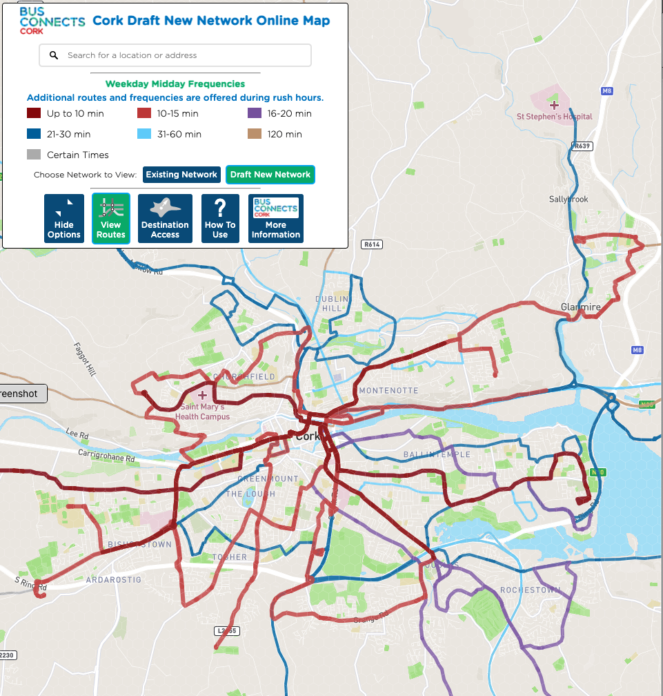
In a metro area of only 300,000, the plan will be able to offer a network that’s mostly every 15 minutes or better (red). (Screenshot from the online map.)
To design the Draft New Network, we held intensive workshops with NTA staff, City and County planners, and the company (Bus Éireann) that runs the buses under contract with the government. We also leaned on public input from July about how to make the toughest network design choices. The Draft New Network would increase overall bus service by over one third, but as readers of this blog know well, within any limited budget – even a growing one – trade-offs must always be made.
What the Plan Would Achieve
When designing the Draft New Network, we kept in mind the first and second priorities of the 1,200 people who gave their input in an earlier phase of the project:
- Reduce vehicle use, by making public transport more useful to more people for more trips.
- Continue to serve all areas that have service today, and add service that covers new parts of the metropolitan area.
These goals are in famously in tension, but even in this fairly small city, the Irish government is funding public transport well enough that we can do a good job on both. It’s a very different situation from what most North American transit agencies face.
Measuring the access provided by the Draft New Network gets at the first goal. Under the plan, the average person would be able to get to 17% more jobs or school enrolments in 30 minutes. (For unemployed and younger residents the benefit is slightly more.) Existing trips would get shorter, and more trips would become possible within a reasonable amount of time.
Residents of some of the densest areas would see their access to jobs and other opportunities expand. Even outside the centre city, some large and growing towns would gain access. For example, Carrigaline – residents near the centre of Carrigaline would gain access to 35% more jobs within an hour’s commute.
Here’s how the network would change where you can go within 30 minutes from Carrigaline Town Centre south of Cork. Dark purple is the area already reachable in this time, while pale purple shows the area that would be newly reachable due to the plan. Grey (there isn’t much) is the area no longer reachable in 60 minutes.
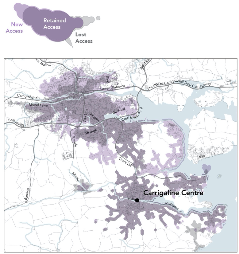
How the plan would change where you can get to in 60 minutes, from the centre of Carrigaline. (That’s the city of Cork in the northwest.) Pale purple is the area newly accessible as a result of the plan.
The biggest reason access would increase is an increase in frequent services in the places where the greatest number of people live and work. Residents within a 5-minute walk of frequent service would increase by 34% (and for unemployed residents, by 56%).
Carrigaline, in the example above, would have 50% more buses departing for the city centre per hour, all day. This not only increases people’s access to the city centre but also to all the places they can go by interchanging with other routes.
To measure improvements that serve the second goal, of maintaining and increasing coverage of the metropolitan area, we counted up all residents and jobs that would be newly close to public transport (regardless of its frequency). The number of residents in the metropolitan area who would be within a 5-minute walk of service would go up by 7%, and the number of jobs would go up by 5%.
Requiring Interchange (Transfers in US Parlance)
The Draft New Network includes a few new nodes in outlying towns, where people would transfer (in Ireland, “interchange”) to reach the centre of Cork.
With improved frequencies, trips involving new interchange can be faster, on average, than direct trips. Is a network that offers better frequencies, and shorter overall trips, but requires some new interchange, worth it?
Some people will understandably be anxious about interchange, or unhappy about what is a one-seat trip today turning into a two-seat trip: What if their second bus is running behind schedule? What if it’s too crowded and they can’t get a seat? What if they’re asked to interchange someplace without a good shelter to wait under? (It rains a lot in Ireland.)
This network redesign is part of a much larger project, called BusConnects Cork, that includes big investments in speed/reliability infrastructure, vehicles, shelters and signage. Much of this is designed to make interchange easier and more pleasant. The question of interchange, then, is not just about route and network design but also about investments in infrastructure that make interchange reliable and comfortable.
Preparing for Light Rail
Cork will build its first light rail line in the next decade, from its western edge to its eastern edge, connecting major universities, shopping centers, industrial areas, the city centre, existing dense housing and planned future developments.
To prepare for this, the Draft New Network includes an east-west frequent bus route that approximates the path of the future light rail line. Offering frequent, all-day, all-week bus service along the light rail corridor before the train is built supports the future success of the rail line. People’s will start to build their habits and their lives around travel patterns that the train will improve once it arrives. The city can permit new buildings before the light rail is built, knowing that they have decent public transit now while waiting for light rail to be built.

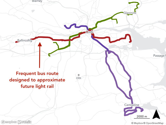
Caption: The three most frequent cross-city radial routes, in the existing network (top) and the Draft New Network (bottom). The colors don’t stand for frequency; they just serve to tell the routes apart. The new network sets up a line resembling the future light rail line.
Changing a long-standing route is always a bit controversial. It’s disruptive for people who know and use the bus network today, because they’ve built their lives and habits around the existing pattern. They’ve chosen where to live, or where to enroll in school, in part based on where they can go easily.
But in most cases, the impact on these people would be that they may have to change buses, but will get where they’re going soon. So is the disruption worthwhile, if the result would be a major expansion in where people can go on public transport?.
More maps and resources are available on the project website.