2-Keepers

Let’s Quit Pretending About Uber

UPDATE: Uber contacted me in response to this post and told me that the advertisement it describes had been taken down.  This response was very encouraging.  This post remains as part of the record, but if you read it, please also read my follow-up, here.


Can we stop pretending that Uber doesn’t want to destroy our high-capacity transit systems?  Because this ad really clears up any doubt, doesn’t it?

uber-ad


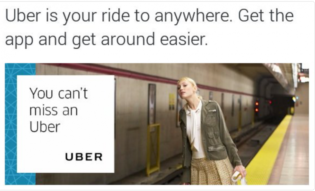
So Uber isn’t even just trying to attract customers off of buses.  This ad shows that it wants them off the subway too.  In this implied vision of the future, most useful transit systems die from elite apathy once the elites are all on Uber.  From this we can deduce that Uber’s notion of the ideal city includes:

  • moving people from big vehicles (transit) into more numerous small ones (Uber), and therefore …
  • increasing the total volume of vehicle traffic, which is to say, increasing congestion, … which means:
  • creating a new imperative to wipe out sidewalks, parks, bike lanes so as to make room for all these cars, and also
  • destroying one of the last few places in the city where a millionaire might sit next to the guy who washes dishes in her favorite restaurant, thus achieving an even more perfect state of rigid class segregation.  In this world, a majority who can’t afford Uber has no good transport options and is therefore pushed further away from the sources of opportunity that they could use to improve their lives.

I apologize if I sound like a killjoy, but the logic here is as firm as the logic behind climate change.

When corporations state their intentions this clearly — especially if those intentions line up with universal corporate goals of growth and profitability — we should believe them.  We should believe that Uber, given the chance, really would lead us into the dystopia of gridlock and class segregation that this ad implies.  And when it comes time for transit agencies to make deals with these organizations, they should know who they’re dealing with.

And yes, when I really need ridesharing (only after checking the transit options first), I prefer Lyft for now, a company that actually seems to respect public transit and wants to complement it rather than destroy it.  And I look for the local companies that are doing the same things.

Because every purchase you make is a statement about what kind of world you want, regardless of whether you mean that consciously.

A response from Uber would be welcome, but really, this ad says what it says, doesn’t it?


“This Is Our Reality”: Pushing Back on Abuse of Transit Staffs

Last week, Taylor Huckaby was manning the Twitter feed at San Francisco’s regional rapid transit agency,  BART, during a tough morning.  Mysterious electrical faults were causing cascading delays, and Twitter boiled over with rage.  Suddenly, Huckaby started tweeting in ways that got attention.bart tweets

Quite deservedly, this and 57 similar tweets went viral, even making it to the New York Times.  Vox, one of the more transit savvy of US national media outlets, got it right:  BART “stopped being polite and got real.

Inspired by Huckaby, let me put this more generally:  Politeness and deference are always the first impulse of transit staffs dealing with the public, but sometimes politeness turns into a habit of apologizing for everything and anything, and at that point, staff is consenting to abuse.  Few public servants take as much public abuse as transit agency staffs do, almost always because of problems that are out of their control.

Imagine Huckaby’s position.  His job is to communicate on BART’s behalf, but because of decades of decisions by past leaders (regional, state and national, not just at BART), his beloved transit system is betraying its customers.  It’s certainly not Huckaby’s fault.  In fact, he understands the issues well enough to know that it’s probably not the fault of anyone working at BART today.

In this situation, the usual vague apologies would amount to misleading the public.  Huckaby deserves his heroic moment, because he did exactly what transit agencies need to do: Find the courage to say the truth, because while people will yell at you when you do, nothing will ever improve if you don’t.  But don’t let me make that sound easy; it’s not.

Some of the early coverage, including that Vox piece, gave the impression that Huckaby had just snapped, “lost it,” gone rogue, but Huckaby has now spoken up to justify his comments, stand up for transit staffs, and properly blame some of BART’s problems on a broader US tradition of infrastructural neglect.  BART management seems to have his back, and Los Angeles Metro tweeted this great video snippet, suggesting that they do too.

Mad at how bad your transit service is?  Maybe the problem is with people and cultures at the agency now, but maybe it’s because of decisions made at higher levels — regional, state, and federal — often outside the agency.  It’s easier if all those people if the frontline staff takes the blame, and are trained to just apologize all day.  But that never solves the problem, and what’s more, it’s abuse.

Luxembourg: A New Official Frequency-based Map

Maps that help people see which services are coming soon are remarkably rare in Europe, for a variety of complex reasons.  Some European systems have such high frequency overall that it may seem unnecessary, but there are usually still significant frequency contrasts that matter.

luxemburg map jug cerovic

Now, there’s a great example out of Luxembourg.  The Paris-based Serbian designer Jug Cerovic has been featured here before, for his interest in making networks clearer by emphasizing a core geometric idea.  Not just for beauty, but as a way of combatting the mental overload that complex maps can cause.

Luxembourg’s transit system has just rolled out an official network map by Cerovic.  It highlights frequency with wide lines, including such details as how wide frequent lines split into narrow infrequent ones.  (Detailed PDF is here.)

unnamed-3

Obviously this is a diagram, seeking network clarity rather than precise fit with local geography. The core geometric idea is the pentagon, a feature of the Luxembourg CBD that he uses, but not to excess, in arranging patterns. He explains his design process here.

UPDATE:  For comparison, this was the previous map. (H/t @ParadiseOxford)

Luxembourg map old

request for professional info: has anyone figured out how to estimate bus layover needs?

So you’re designing a new rail line, which will require bus connections at many points.  These bus lines are important.  They extend the reach of the rail line, and they are fundamental to how everything fits together as a complete network that anyone can use.

On some parts of the alignment, it appears logical that many bus lines will terminate at a rail station.  This means that they will need to lay over — sit for a while so that drivers can have breaks — and that takes space.  You also want your rail stations to be vibrant urban places, so redevelopment needs are likely to conflict with bus layover needs for urban space, and it’s obvious which one will excite politicians and citizens more.

Yet the layover is essential.  If it’s not there, buses have to drive further to get to other layover locations somewhere beyond the station, and all that time is money out of the operating budget, that comes at the expense of service that customers can actually use.

The critical problem is how to estimate long-term layover needs.  At many agencies, operational service planners who spend almost all their time working in a 1-5 year timeframe are suddenly asked how many layover bays they will need for a project that opens ten years from now and needs to function for 50 years after that.  Obviously, they have no clue.  They have a sense of how the logic of the network tends to cause lines to converge at a station or not, but they can’t guess how high demand will be in 40 years, or even what the size and shape of the buses running then will be.  (One reason to expect a renaissance of double deckers is simply the intense presure to conserve curb space while maximizing capacity — a big problem for the double-decker’s competitor, the articulated bus.)

So faced with all that uncertainty, all planning staff can do is guess very high about how much space they’ll need, which amplifies the conflict with other development — and also with project construction cost.  In the worst case, the estimated layover need conflicts so dramatically with everyone else’s needs that they get ignored.

The conflict is totally understandable from everyone’s point of view.

Has any agency solved this problem to everyone’s satisfaction?

I’m pretty sure the answer is no, but would love to see some inspiring stories about how you’ve gotten close.

Comment Policy

Human Transit welcomes and encourages comments from people who want to

  • share relevant information, including narratives about their own experience, or
  • ask questions, or
  • engage in thoughtful conversations that could potentially transform or enrich their own views.

The following policies and guidelines are intended to foster such an environment.  I reserve the right to delete comments for violating any of these policies. Continue Reading →

San Francisco: The Paper Clip Snaps

DSCF3808

The Bay Bridge connecting San Francisco with Oakland (and most of the continent) has been closed for several days.  SF Chronicle :

The bridge was shut down Tuesday evening. High winds and heavy
traffic loosened a pair of tie-rods and a steel bracket that was
installed Labor Day weekend to take pressure off a fracture discovered
in a structural beam – an eyebar – on the eastern span.

The 5,000-pound assembly crashed onto the upper deck, totaling three cars during the evening commute. Continue Reading →

Just Asking …

DSCF9178 We’ve all seen wide, high-speed suburban boulevards where it’s not safe to cross the street anywhere but the occasional huge signalized intersection.

Yet there are often bus stops on these boulevards far from those signals.
Since most transit trips are round trips, and most services are two-way, most passengers need to use the stops on both sides of their street.  They depart from a stop on one side but usually return to a stop on the other side.
So a pair of stops isn’t really functional unless it’s safe to cross the street at that point.


Continue Reading →

Suppose Money is Like Water

Strogatz-detailed.950.cw Steven Strogatz has a intriguing column in the NY Times about a 1950s era “hydraulic computer,” which modelled the operation of a national economy using fluids flowing through a machine.  As the water circulates it fills or empties tanks, trips levers, and occasionally plots a graph of the level of a particular tank through time.  For example, when a tank called “Minimum Working Balance” fills up, it begins overflowing into a stream called “Income.”     (Click to enlarge.)  The thing has a series of input points where you can change something (modelling an external input of some kind) and see what happens as a result.
The commenters seem to focus on how charmingly obsolete the thing is, but my first reaction was:  What a great teaching tool!  Someone should create working online model of it, complete with all the rushing and gurgling sounds, that we can all play with on our laptops.
In a democracy, the greatest threat to national security is public ignorance.  The same is true of a democratically governed city.  That’s why as a transit planner, I’ve come to view explaining what I do as one of the most important parts of my job.

Continue Reading →