Most of the goals that we expect public transit to pursue have just turned upside down. Ridership was an important goal two months ago, but now public transit agencies are telling customers to stay away if they can, restricting service to “essential trips.” These trips are critical, though, to the functioning of society. You could even argue, as I did in Citylab recently, that transit is helping prevent the collapse of civilization.
But now transit authorities are having to cut service. This post examines why, and how they should do it. It’s long, so there’s a table of contents:
Contents
- Why Cut Service?
- Why Not Shut Down?
- What Service Should be Cut?
- What Agencies are Doing, and May Do
- Three Stages of Adaptation and Recovery
1. Why Cut Service?
Why cut service at all in this situation? There are two compelling reasons:
- Staff availability. Some critical staff are sick, and it’s likely that every transit employee is at least worried about being sick. So right now, there just aren’t enough people showing up for work.
- Saving money. In the US, the Federal CARES Act will keep transit agencies whole for a couple of months but requires them to continue paying all their staff. But the financial prospects are dire in the longer term, so some agencies are trying to save money so that they can keep going a little longer if the federal funding dries up. In countries where no emergency funding is being provided, many agencies will run out of money very soon if they don’t cut their service dramatically. (Vancouver’s TransLink, for example, has been told not to expect support from the Canadian federal government, and will have to “deconstruct” much of the network as a result.)
2. Why Not Shut Down?
This is a brutal time to be a bus driver. Already some services have been shut down by union action and some labor leaders are demanding more shutdowns. Some transit systems — such as the one in Windsor, Ontario — have shut down completely with no particular attempt to provide alternate solutions for the “essential services” workers.
Apart from the workforce safety issue, would it be cheaper to shut down transit and just subsidize Uber-Lyft rides for all essential services workers? That math only works if you truly lay off the workforce. This is not what the unions have in mind, and in the US it’s expressly prohibited for agencies taking the Federal CARES act rescue funds. It also means that when economic activity resumes it will take more time to get the agency restarted, potentially creating a long period when lots of people need transit and it’s just not there. Meanwhile, while keeping people 6 feet (2m) apart is certainly hard on public transit, it’s impossible on the Uber or Lyft. You’d need a van to carry just one passenger in addition to the driver.
3. What Service Should Be Cut?
Easy Options
If service has to be cut, how should it be cut, and with what priorities? Two cuts are really obvious and most agencies have done them:
- Tourism and recreation services. These markets have vanished. San Francisco, for example, has replaced its cable cars with buses. Many downtown circulators and trolleys, especially those justified by tourism, have shut down.
- Service usually added for rush hour, unless it’s the only service to an area. The “essential service” trips that are still on transit happen all over the clock with very little peaking. The huge nine-to-five peak created by white collar workers is nearly gone, and of course the school peak — a big one in many agencies — has disappeared entirely. Peak-only service is expensive, so it’s a logical first thing to go as long as people along those routes have a local service option to complete essential trips.
Difficult Options
- Cut frequencies. Most agencies have done it. but it’s dangerous. A common misconception is that if you cut frequency, people still have “access.” But lower frequency means longer waits for connections, so this can cause massive increases in travel times. A trip that takes longer than people have in their day might as well not be served at all. A good guideline, which several agencies are following, is to cut very frequent services to run only every 15 minutes, the worst frequency at which connections are still viable, but resist cutting further.
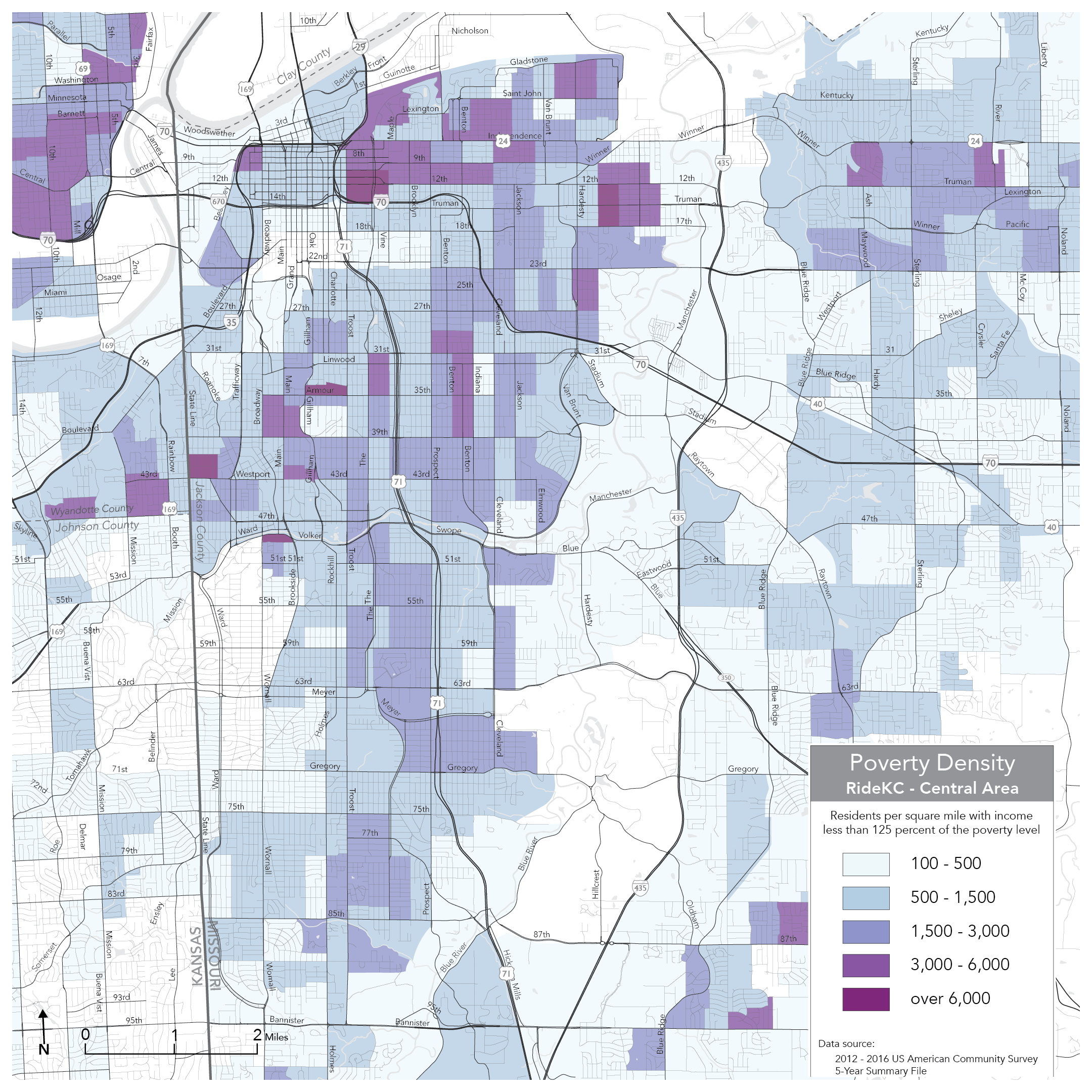
- Abandon service to some areas entirely, while focusing on “essential” destinations. Many agencies have plotted the locations of essential services, especially medical centers, and retained only routes serving those. The problem here is that the workers who need to get to those places live everywhere. To make all essential trips possible, you need a degree of citywide access, at least to all areas where incomes match the typical pay of essential workers.
- Cut duration of service. This totally abandons some essential shift workers, especially in the 24/7 medical world. Most transit agencies were already offering little or new overnight service, and closure of restaurants and entertainment has eliminated most of the ridership of evening service. But further reductions of span can still be a problem for essential services workers, who may have to travel all over the clock.
- Increase walking distances consistently. In a grid network where there are routes about every half-mile or 1 km, just turn off every other route, so that walking distance to transit increases but everyone still can get to some service. More on this interesting option below.
4. What Agencies are Doing, and May Do
The most common quick response to the crisis has been to go to Saturday or Sunday schedules. This effectively does a bit of everything on the “difficult options” list. It’s totally reasonable as a quick response. Saturday and Sunday schedules already exist, have already been approved by both union and management, and are relatively easy to turn on. The normal process of writing, approving, and implementing a schedule takes months, with procedures that tend to be strictly defined in labor contracts. Many agencies have found their unions to be motivated to help make things work in the crisis, but that approval process still takes time. So it’s understandable that using weekend schedules was the thing that could be done fast.
Still, several agencies have already managed to implement more carefully designed service cuts. Cleveland’s RTA, for example, has completed a service cut with revised schedules reflecting detailed thought about every route and how to make a minimally functional and connective system. In their case, the suburbanization of low income means they can’t cut any coverage, but they’ve turned off their downtown shuttles and carefully chosen frequencies for each route to optimize travel times.
It’s critical that transit agencies do these designed reduced networks they have time to think about it. Many transit agency Sunday schedules are just the daytime network run less frequently, and often don’t work very well because it can take an hour to change buses. But transit agencies will be running on reduced demand and resources for some time, so more careful design is needed.
San Francisco and Philadelphia (within the city) are among the cities where the cuts have tended to protect frequency bhy increasing walking distance — though of course this works best in old cities that are relatively walkable. San Francisco has turned off many routes and thus increased walking distances to about a mile but in return its frequencies are 20 minutes or better everywhere, so once you’ve walked to a functioning route you can be on your way. Their new “Core” network doesn’t immediately show a consistent route spacing, because their initial design was limited to turning existing routes off or on, but if this goes on I wouldn’t be surprised if they start doing modest restructuring to improve the amount of useful service they can provide with such reduced resources.
5. Three Stages of Adaptation and Recovery
From what agencies are doing, and the facts behind them, I think we can identify three stages that agencies are going through, or likely to go through, as they deal with the combination of (a) suddenly needing to cut service and (b) retaining the ability to slowly grow service back as demand returns, knowing that the pattern of new demand may be different from the old.
Stage 1. Emergency cuts. These cuts, mostly done by now, are necessarily rushed and crude, such as going to weekend schedules.
Stage 2. Designed cuts. When time permits, refine the schedules to better reflect actual patterns of “essential services” needs during the emergency.
Stage 3. Strategic design. While Stage 2 generally works with the existing network structure, this stage may revise routes or even redesign some services. You would do this, though, only if you think that redesign will probably continue making sense as demand returns.
Everyone knows that when this crisis passes, they will emerge into a different world with different patterns of demand. The usual controversy around network changes, where we disrupt patterns that people are used to, will no longer apply, because nobody’s used to anything at the moment, and we all know the new world will be different from the old. We can anticipate some reasons that the return of service will need to follow new patterns: People who can drive will be slow to return to transit, but people without a good option of driving will show up in much greater numbers. So service priorities optimized for the latter may be the best way to bring service back, and that’s not always what existing route structures are designed to do.
In short, like all crises, this is an opportunity. And because this is a big and enduring crisis, the opportunity is big and enduring too.