Density

The rise of “Super Commuters”

The Apartment List Rentonomics blog, which writes on real-estate statistics and economics, recently posted a census analysis on the “Rise of Supercommuters”.  It describes a recent increase in the percentage of people with commutes 90 minutes or longer each way.  This thoughtful analysis is well worth a read.  It finds that:

  • Nationwide, one in 36 commuters are super commuters, traveling 90+ minutes to work each day, spending hours on public transportation or battling traffic.
  • Super commuting is becoming increasingly common: the share of super commuters increased 15.9 percent from 2.4 percent in 2005 to 2.8 percent in 2016.
  • The share of super commuters is highest in expensive metros with strong economies — New York, San Francisco, Washington, D.C., Atlanta and Los Angeles, and in their surrounding areas.
  • Super commuters are more likely to rely on public transportation than those with shorter commutes. An estimated 91.4 percent of non-super commuters drive to work, compared to just 69.7 percent of super commuters.
  • In most U.S. metros, low-income commuters are more reliant on public transportation than high-income commuters, creating a nexus between super-commuting and poverty. When transit usage falls sharply with income it suggests that transit is used out of financial necessity rather than as a lifestyle choice.

But the term “Super Commuter” sounds too heroic.  “Super commutes” aren’t something to celebrate.  People should be free to arrange their lives this way, but shouldn’t be forced to by the housing market.

For the commuter, spending three hours of unpaid time a day commuting is only a response to a lack of reasonable alternatives.  For taxpayers, it represents a high cost- both in providing infrastructure, and in increased traffic congestion.  The US Census itself calls commutes over 90 minutes “Extreme commutes”.  That to me, better describes these long commutes- they are something that a few people may have to do because of their job or family situation, but something that shouldn’t be made the new normal.  “Extreme” also captures the right connotation.  As in “extreme sports,” it suggests something that most people would rather watch than do, and that many don’t even want to hear about.

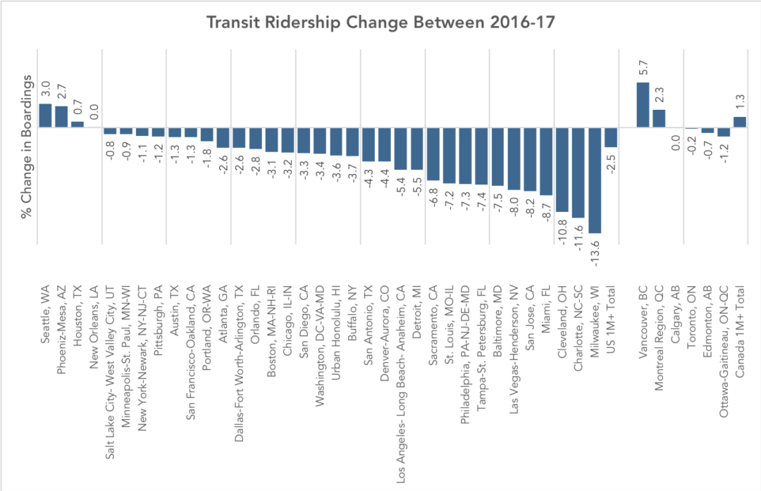
We can also draw parallels between increases in in the prevalence of these extreme commutes and the decrease in overall transit ridership over the past few years.  They are both symptoms of the suburbanization of poverty, and to some extent, the middle class.  These suburbs are not geometrically conducive to high-ridership transit, and as a result the transit options are poor, so many people who move there, resort to driving.  But driving such long distances every day can cost thousands of dollars over the course of a year, so some people would still rather endure the low frequencies and limited spans of suburban transit service to access the city.

The article goes on to conclude that:

Reversing the growth in super commuting requires investment in both increasing housing supply and improving transportation.

Both increasing housing supply and improving transportation have the potential to reduce commute distances, but the location of this new housing and improved transportation are crucial.  Transit always achieves higher ridership per hour of service in dense, mixed-use urban centers, than in unwalkable outlying suburbs, so if we want to reduce the percentage of transit commutes that take more than 90 minutes each way, we will have to substantially increase densities in places where fast, frequent, and useful transit is most feasible.  That means a mixture of housing and jobs, and building up, not out.


Why Does Ridership Rise or Fall? Lessons from Canada

by Christopher Yuen

With only a handful of exceptions, transit ridership has stagnated or been falling throughout the US in 2017.  The causes of this slump have been unclear but some theories suggest low fuel prices, a growing economy fueling increased car ownership, and the increasing prevalence of ride-hailing services are the cause.

A few North American agencies have bucked the trend, including Seattle, Phoenix, Houston, and Montreal.  By far the biggest growth was at Vancouver, BC’s Translink, which saw a ridership growth of 5.7 percent in 2017.

But notice the big picture:  In a year when urban transit ridership fell overall in the US, it rose in Canada.

Transit ridership urban areas with populations of over 1M are included in this chart. Ridership of major agencies that serve the same region are added together. (Source: National Transit Database; APTA 2017 Q4 Ridership Report)

There are three interesting stories to note here.

1.  If You Run More Service, You Get More Riders

Canadian ridership among metro areas with populations beyond one million is up about 1.3% while regions of the same size in the US saw an overall ridership decrease of about 2.5% in 2017 despite the broad similarity of the countries and their urban forms.  Why?  Canadian cities just have more service per capita than the most comparable US cities.  This results in transit networks that remain more broadly useful in the face of competition from other modes.  Note, too, that Canadian transit isn’t cuter, sexier, or more “demand responsive” than transit in the US.  There is simply more of it, so more people ride, so transit is more deeply imbedded in the culture and politics.

2.  Vancouver Shows the Effect of Network Growth, Higher Gas Prices, Great Land Use Policy, and No Uber/Lyft

Vancouver’s transit ridership has historically been higher than many comparable regions as a result of decades of transit-friendly land-use and transportation policies, including an early regional goal to foster density only around the frequent network.  (The Winter Olympics also had a remarkable impact: ridership exploded in 2010, the year of the Olympic games, but then didn’t fall back after the games were over; apparently, many people’s temporary lifestyle changes became permanent.)  By North American standards, Vancouver is remarkable in the degree to which development is massed around transit stations.

But Translink attributes its 2017 ridership growth to continued increases in service, high fuel prices, and economic growth.  The 11km (7mi) Millennium-line Evergreen Extension just opened prior to 2017, directly adding over 24,000 boardings a day.  Fuel prices in Vancouver have also reached an all-time high, at $1.5 CAD / litre (4.4 USD/ gal), an anomaly in North America, although still lower than in Asia and Europe.  Economic growth has also been consistent, with the region adding 75000 jobs in years 2016 and 17.  Notably, ride-hailing services like Uber and Lyft are not available in Vancouver due to provincial legislation.

3.  There is Conflicting Evidence on the Impacts of Economic Growth on Ridership

Many commentators suggest economic growth to be a factor of the 2017 trends in transit ridership but there seems to be two conflicting theories, with economic growth cited as both a cause ridership growth and a cause of ridership decline. The positive link is obvious- economic growth leads to more overall travel, some of which will be made by transit.  Contrastingly, the negative link is based on the theory that increasing incomes allow for more people to afford cars.  Both theories seem plausible, but for both to be true, the relative strength of each must differ between cities.

Most likely, economic growth in transit-oriented cities is good for ridership, and growth in car-oriented cities, which encourages greater car dependence and car-oriented development, is bad.  This would explain the roaring success of Seattle, Vancouver, and Montreal, though it doesn’t explain why Houston and Phoenix are doing so well.

As North American cities work to reverse last year’s losses in ridership, they may best learn from Canada, and a select few American cities, to leverage economic growth for ridership growth.

Postscript by JW

For Americans, Canada is the world’s least foreign country.  There are plenty of differences, but much of Canada looks a lot like much of the US, in terms of economic types, city sizes and ages, development patterns, and so on.

So why is Canada so far ahead on transit?   All Americans should be asking this.  Ask: Which Canadian city is most like my city, and why are its outcomes so different?  We’ll have more on this soon.

Toronto: A new King Street for Transit

By Christopher Yuen

For the past few decades, Toronto’s King Street, a frequent transit corridor through the densest and fastest-growing parts of the city, has been increasingly choked by car traffic. Built before the age of the automobile, and running in mixed traffic as was typical with legacy streetcar systems, the 504 King streetcar’s speed has deteriorated to just about walking speed on most days during rush hour. That was until three weeks ago, when the City of Toronto launched a one-year pilot project to restrict car traffic and give transit the space it needs to move. The Globe and Mail has a great piece on the significance of this project here. Details on the project and its design are available at the City of Toronto website here.

King Street Pilot Plan Diagram excerpt

The King Street pilot project prioritizes transit.

The new design of 4-lane King street was particularly thoughtful, given some of the constraints the corridor faces. While transit malls in some cities completely ban non-transit vehicles, existing high-rise parking garages that front onto King Street and businesses throughout the bustling entertainment district without back lane for loading and deliveries meant that vehicular access had to be maintained. Under the new design, left turns and through-travel are prohibited for cars and trucks at all major intersections- requiring drivers to turn right and use alternate streets.

At the approach to intersections, vehicles waiting to turn right form a queue in the right lane, out of the way of transit. At some intersections, cars receive an advance turn signal ahead of pedestrians to ensure the tail of the turning queue does not impede the streetcars.

Taken on a weekday at 4:00pm, this scene would have been much more chaotic with through-traffic blocking transit before the project. Now, cars are channeled to turn right at every intersection. (Photo: Alex Gaio)

Taken on a weekday at 4:00pm, this scene would have been much more chaotic with through-traffic blocking transit before the project. Now, cars are channeled to turn right at every intersection. (Photo: Alex Gaio)

Without through-traffic, having two lanes at the start of each block is no longer necessary, allowing for an important feature for efficient transit operations- far-side stops. Streetcar tracks in Toronto, and in many legacy systems, operate in the middle of the road. To board and alight, passengers must step into the roadway, protected only by a rule prohibiting motorists from passing open streetcar doors. As a result, stops have always been located on the near-side to reduce the risk of drivers making a right turn onto a transit corridor and immediately conflicting with passengers getting on or off a streetcar. Under the new design, streetcars stop on the far side of most intersections, beside barriers that effectively extends the curb to the second lane at the start of each intersection.

New far-side stops with a temporary curb-extension mean passengers no longer have to walk through a traffic lane to get on and off the streetcar. (Photo: Alex Gaio)

New far-side stops with a temporary curb-extension mean passengers no longer have to walk through a traffic lane to get on and off the streetcar. (Photo: Alex Gaio)

In addition to the obvious safety benefits of the new design, the far-side stops also allow transit vehicles to travel faster. Traffic signals along Toronto’s King Street already feature transit signal priority- they detect an approaching transit vehicle to hold a green light, or shorten a red light. With near-side stops, the unpredictable dwell times at stops would sometimes cause the traffic-signal to time-out, leaving the transit vehicle with a red light just as it closes its doors and is ready to get moving. Far side stops allow signals to be held for a streetcar to get through an intersection before stopping for passengers.

The new design also re-allocates curb space as loading zones, taxi stands and for new seating and patio space mid-block- all valuable features for a dense, mixed-use central business district which would not have been possible when all four lanes have been dedicated to the throughput of cars.

New public spaces like this will become especially valuable when patio season begins.

New public spaces like this will become especially valuable when patio season begins. (Photo: Alex Gaio)

Since its launch, public support has been for the most part, positive. The all-at-once approach to implementing this pilot across the corridor has ensured that the new inconvenience to some drivers has also been matched with a drastic, noticeable, and immediate improvement for everyone else. Across the twittersphere, Torontonians are reporting anecdotes of more consistent departures and trips taking half as they did previously.

Even among some taxi drivers, subject to the same turn restrictions throughout the day, initial skepticism appears to have eased.

Preliminary analysis of GPS data shows that the project is working, significantly reducing both the average and the spread of travel times.  However, it remains to be seen if enough drivers will comply with the new restrictions once the initial enforcement blitz is over. If New York or San Francisco‘s bus lanes offer any guidance, Toronto should introduce automatic camera enforcement along the corridor. Over the course of this one-year pilot project, municipal staff and the transit agency will be sure to monitor the situation closely and make adjustments based on actual results.

Cities, faced with growing populations and spatial constraints, must defend the right for transit to move if they wish to limit the negative impacts of traffic congestion. Toronto’s King Street offers a story of how that can be done quickly and effectively.


Christopher Yuen is an associate at Jarrett Walker+Associates and will be regularly contributing to this blog.

How Important is “Downtown”?

In North America, the word downtown invites us to imagine the densest and most walkable part of any city, the place where transit and other non-car modes naturally thrive more than anywhere else.  And where this is actually true, it's logical for all kinds of intercity and local transit services to focus there.

But when we project this model of downtown onto every city, we encounter fatal confusions.  Downtown implies a single place; there's just one per city or metro area.  But some cities aren't like that.  Los Angeles and Houston, two take two famous examples, have a place called downtown, but it's really just a slightly larger cluster of towers among many clusters of towers dotted across the region.  Downtown in this model is not like a center of energy around which the whole city revolves.  It's like the brightest of a bunch of stars in a constellation, and not even the brightest by much.  

So if you cling to the notion that downtown means "focal point of travel demand and especially transit", then you have to embrace the concept that an urban area may be a constellation of many downtowns.  This is not just an American sunbelt idea.  Most of the population of the Netherlands is in a single metro area called the Randstad; it's made of many small cities each with its own downtown, with a shared airport near its centroid.  Many Asian cities are so uniformly and extremely dense that almost any point in the city could be called downtown, so long as there is some mixture of uses.  All of Paris is about equally dense, with government, business, and retail districts all over the city and the tallest towers around the edge of it, so good luck finding "downtown" there.  

In Citylab, Eric Jaffe gives us the supposedly bad news that the proposed Dallas-Houston High Speed Rail (HSR) line won't go to "downtown" Houston.  Instead it will end at Northwest Mall, just outside the I-610 loop in the northwest of the city.  

But most of the Houston transit-advocates I've talked with aren't sounding nearly as upset.  That's because:

  • the proposed terminal is close to the centroid of Houston as a whole.  It's also very close to Uptown-Galleria, the region's second downtown, and to Northwest Transit Center, the busiest transit hub in the western 2/3 of the city.
  • the terminal station area is massively redevelopable.  You could easily build yet another downtown there, and if HSR is built, they probably will.
  • the project will provide great impetus for light rail or Bus Rapid Transit linking the station to the original downtown.  These projects have been sketched many times and could include either I-10 nonstop links or a refurbishment of Washington Street, a promising old streetcar street linking the two nodes.
  • in high speed rail, the cost of the last miles into an historic downtown can be a huge part of the cost and grief of the whole project.  So if you want high-speed rail to happen at all, provoking this battle is not always a sensible part of Phase 1.

The bigger challenge, for folks from strongly single-centered cities, is to notice the limits of the term downtown.  As cities grow, there is no correlation between the sustainability of a city and its single-centeredness.  On the contrary, single-centered cities present huge problems for transportation, because they use capacity so inefficiently.  New York, for example, is spending over $10 billion on a project to fit more Long Island commuter trains into Manhattan, and to put them closer to jobs there.  The demand is mostly one-way, so this requires either storing trains all day on expensive Manhattan real estate, or running them all empty in the reverse-peak direction.   It's very inefficient compared to the transit problem in a multi-centered place like Paris or Los Angeles, where demand is flowing two-way most of the time.

So growing a single downtown isn't the key to becoming a great transit city.  Quite the opposite, it's best to have a pattern of many centers, all generating high demand, and supporting balanced two-way flows between them that let us move more people on less infrastructure.  This is the great advantage of Paris or Los Angeles or the Dutch Randstad over Chicago or Manhattan.

So remember: when it comes to the efficiency and abundance of transit — or roads for that matter — "downtown" isn't all it's cracked up to be.  For transit, big clumps of density and walkability are great, but several are better than one.

shared housing and shared transportation (guest post by alfred twu)

Alfred Twu lives in the Bay Area and is a long time transit rider.  He has studied architecture and business and is also an active participant of the cooperative movement, having worked in artist, food, and housing co-ops. He is also an illustrator for my forthcoming book Human Transit.

Also known as cooperative living, co-ops, communes, intentional communities, or living with roommates, shared housing creates challenges and opportunities for transit service.  It can increase density without zoning changes or construction.  However, good transit service needs to already exist for this to happen.  As such, shared housing's greatest potential is in increasing utilization of under-zoned but well served neighborhoods. 

What is shared housing?

Shared housing denotes a group of unrelated people live in a single dwelling unit.  Kitchens, bathrooms, and other living areas are shared, bedrooms may be shared or single occupancy.  In the Bay Area, this model is known as a co-op or cooperative.  Note that the word co-op has an entirely different meaning on the East Coast.

Shared housing has a long history in the Bay Area, dating back to boarding houses.  The modern Bay Area cooperative housing movement began in 1933 with the founding of the Berkeley Student Cooperative

Although some structures are built with shared housing in mind, usually the building is simply a repurposed large house.  For example, Ridge House, a 38 person student co-op, used to be a mansion, while Cooperative Roots, pictured below, houses around 20 people in two adjacent single family houses.

Cooperative_roots

What does this have to do with transit?

Let's look at two neighborhoods: one dense, and one sprawling.  The denser neighborhood will usually have better transit service.
Dense-vs-sprawl
Now, if zoning ordinances prevent additional housing from being built in Sprawlville, that does not mean it's the end of the story.  While zoning typically concerns itself with units per acre, the density that matters for transit service is population per acre, or more specifically, commuters per acre.

This is where shared housing comes in.  When a neighborhood of single family houses goes from having one or two working adults per house, to having 4 to 8 working adults, as far as transit is concerned, it's a high density neighborhood.

Sprawl-with-sharedhousing

The catch to this though, is that this can only happen where there is already good transit service.  When a group of people share a house, they'll all want easy access to their jobs, which may be in different directions.  Not all of them will take transit either – some of them will need to drive to their jobs, some people prefer to bike.  This is why shared housing works so well with college students – everyone is going to the same place for their "job", so only one frequent route is necessary.

Case Study: Ashby BART
  (San Francisco Bay Area)

A number of my friends who used to live in shared housing as students have formed their own communities after graduation.  Most are now in their mid 20s to early 30s.  Some work office jobs with traditional 9-5 hours, others work retail jobs with varying hours.  Over the last few years, about 30 communities of 4 to 18 people have been formed.  Most cluster around the Ashby rail rapid transit station.  Let's examine why.

  • It is about halfway between the two big job centers in the area: UC Berkeley and Downtown Oakland.
  • It is 20 minutes on rapid transit to the region's largest job center, downtown San Francisco.
  • It is close to freeway on-ramps.
  • It is on flat ground and within biking distance of a large number of commercial districts.  Bike access is important since transit service in the evenings and on weekends is limited.
  • It is not in itself a downtown district.  This means there are a lot of large houses with lots of bedrooms and yards – the preferred housing type.
  • There are already other co-ops in the area.

The one co-op not near a BART station — an outlier near the bay — is an artists' warehouse.

Co-ops and transit

Ashby Station: Excellent transit service but low density

The Ashby station neighborhood, which currently consists of mostly single family houses, had long been targeted by planners for transit oriented development.  It has an underground rapid transit station with train frequency of every 7 minutes on weekdays and 20 minutes at night and on weekends.

Ashby station neighborhood.  Station is blue, parking lot is black.
Ashby

However, the official plan to build 300 units of housing on the station parking lots met significant neighborhood opposition.  Existing residents were concerned about losing the flea market that currently operates on weekends in the parking lot, increased traffic, and future upzoning of the area.  The project was put on hold in 2006. 

Shared housing, however, has achieved something similar with no official intervention.

Can the Ashby model be replicated elsewhere?

Using shared housing to increase neighborhood density offers a solution for low density areas where economic constraints or zoning limits the ability to build new housing units.  The following factors are needed for its success:

Multimodal Job Access

Members of a shared house with long commutes tend to move out.  Therefore a location needs good access to members' existing jobs, and potential future ones.  Transit is just one part of the equation – those working 9 to 5 hours downtown.  For the other members, good car and bike access to nearby commercial areas is needed for those working retail and service jobs on evenings and weekends. 

Catalyst community and clustering effect

The Ashby area community began with just a couple of houses.  However, the community grew rapidly as the original residents' friends also wanted to live nearby.  UC Berkeley provided a feeder system with many members having already familiarized themselves with shared housing through living in the Berkeley student co-ops.  In places far from colleges, immigrant neighborhoods can also benefit from the feeder effect.

One of the side benefits of shared housing is a group of residents will have a lot of purchasing power with their combined incomes, and will seek out the area that meets their needs best.  Until most people live in shared housing, this means that a region will likely have only a small number of preferred neighborhoods.

Why not MacArthur?  Station placement matters.

The next station down the line, MacArthur, is even better positioned in terms of access to transit and jobs.  However, this station is located in a freeway median.  As a result, a lot of the land walkable to the station is either paved over, or so close to a freeway that it is an unpleasant place to live.  As a result, even though this area has been zoned for multistory apartments, few have been built.

Macarthur

Creating community: the station as social hub

Shared housing in the Ashby area occurred without any official planning – an existing community (recent UC Berkeley graduates) simply moved in.  Where no existing community exists, social hubs such as coffee shops or community centers, located inside or directly next to the station, can aid the formation of the close relationships that shared housing requires.

basics: conceptual triangles

Sometimes, we have to think in triangles.

In the transit world, for example, we know that ridership arises from a relationship between urban form (including density and walkability) and the quantity of service provided.  For example, if we focus on local-stop transit, the triangle looks like this: Continue Reading →

The Perils of Average Density

In his 2010 book Transport for Suburbia, Paul Mees notices a fallacy that seems to be shared by sustainable transport advocates and car advocates.  Both sides of this great debate agree that effective transit requires high density.

Sustainability advocates want higher urban densities for a range of reasons, but viability of public transit is certainly one of them.  Meanwhile, advocates of car-dominance want to argue that existing low densities are a fact of life; since transit needs high density, they say, there’s just no point in investing in transit for those areas, so it’s best to go on planning for the dominance of cars.  Continue Reading →