About a year ago, our firm started helping the Kansas City Area Transit Authority (also known as KCATA or RideKC) on a short-term bus network redesign for the City of Kansas City, Missouri (KCMO). While the regional agency covers a larger area, this study is only for KCMO, which pays for transit service directly from city funds.
The Draft Plan for this redesigned network was released last Friday, and you can read up on it at RideKCNext.org. If you live in Kansas City, there’s also an online survey, which you should respond to before March 16th.
This plan was not easy. Kansas City is an extraordinarily challenging place to plan transit service, a perfect storm of all the issues that beset most large US cities:
- Low-density built environment combining hollowed-out parts of the urban core and ever-increasing suburbanization.
- profound residential segregation by income and race.
- some awkward jurisdictional boundaries, especially north of the Missouri River. These matter because local funding arrangements mean we had to think about the City of Kansas City separately, which in some places can be like thinking about only the black squares on a chessboard.
At nearly 500,000 people, Kansas City, MO, is only a third of the Kansas City region by population. But this includes nearly all the region’s relatively dense, transit-oriented areas. KCMO also provides about 80% of local transit funding, and 90% of all regional transit ridership originates in KCMO.
The Good News
First, the good news. As a result of the Draft Plan, nearly 20% more KCMO residents would live near frequent service, with a bus coming every 15 minutes or better.
Weekend service would also be greatly expanded, with service every 15 minutes on Saturday, and every 20 minutes on the eight most important routes in the network.This compares to the You can see the expansion of the frequent network, and improvements in weekend service in page 11 of the plan, shown below. (Click to enlarge and sharpen)
Put together, these changes would go some way to address the biggest problem of Kansas City’s bus network, which is that it just doesn’t provide enough access to opportunity. If the Draft Plan were implemented, the average KCMO resident could reach 7% more jobs on weekdays, and 22% more jobs on Saturdays in 60 minutes or less using transit (including any time spent walking, waiting, or transferring), all with no new investment in service.
As you can see above, the big expansion of access is the result of an expanded frequent grid with more frequent east-west elements. This is especially urgent because of the geography of race and income. Kansas City (south of the Missouri River) features a north-south strip on the west side where almost all of the prosperity is, and, further east, a north-south strip that is heavily low-income and minority residents.
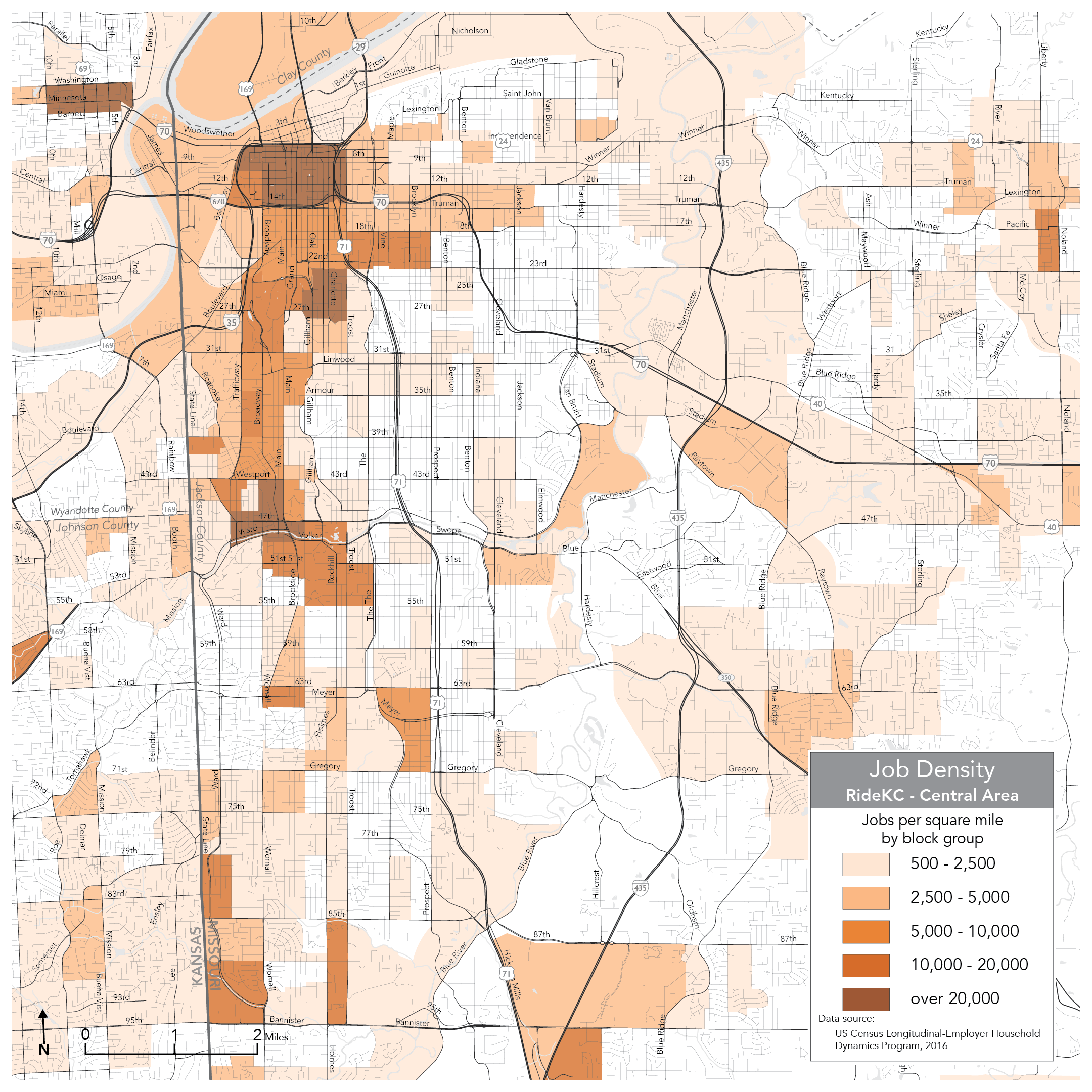
Job and opportunity density is concentrated in a north-south strip on the west side of the city.
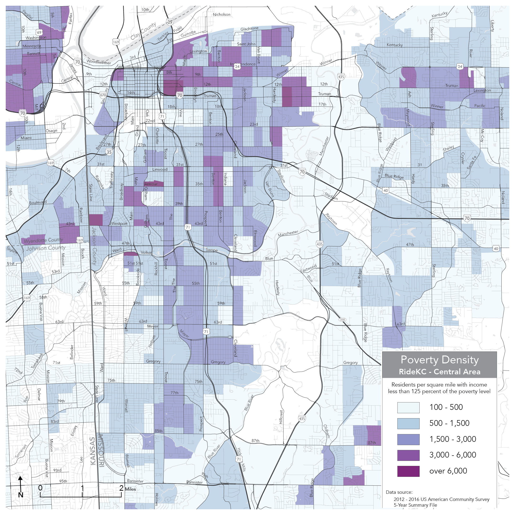
Low income (and minority) residents mostly live further east.
Most existing frequent transit in the city is north-south, converging on downtown at the north end. But low income people need to get from their homes in the east to wherever they are going on the west side of the city, not just downtown. A high frequency grid does this. People can travel westward more easy to connect to whichever north-south route meets their needs. For that reason, much of the plan’s benefits arises from improvements in east-west frequency on streets like 12th, 39thand 47th/Blue Parkway.
Difficult Tradeoffs
But this good news comes at the cost of some painful compromises. The plan is designed for fast change, and KCATA is in the midst of a parallel effort to eliminate transit fares in KCMO. So the Draft Plan assumes no new revenue is available.
That means all proposed improvements would come at the price of service reductions somewhere else. In the urban core, the plan would remove several infrequent bus routes that operate ¼-mile or less from a more frequent route. In outlying areas, the plan would entirely remove bus routes from several neighborhoods where ridership is extremely low. Overall, about 1.5% of KCMO residents would no longer be within ½-mile of any kind of transit.
Perhaps the most obvious shortcoming of the plan is that it would continue to provide very limited service in the suburban Northland, where over a third of KCMO’s population live, but densities are much lower and average incomes tend to be a little higher.
Ultimately, it’s a lot harder to efficiently invest KCMO’s very limited transit resources in the Northland. This is because relatively few people live close enough to any street where you might run a bus, the street networks make it harder to walk, and destinations tend to be far apart. And much of the Northland’s most likely transit street (North Oak) is located in enclave cities who contribute much less for service, reducing KCMO’s incentive to invest.
See below for full maps of the existing and proposed network. Because KCMO covers such a large area, you’ll be able to see these a lot better by clicking and expanding them. You can also get a detailed view of how transit service would change in each part of Kansas City by clicking here.
Existing network.
Proposed network.
As consultants, we make no claim that this is the best of all possible transit networks from KCMO. It’s clear to us and to KCATA that Kansas City would benefit from investing significantly more money in transit service; the plan identifies several incremental improvements that KCATA should prioritize if revenues improve. But we think this is what can be achieved with the resources currently on the table.
(with Daniel Costantino)
 A New Years Letter is supposed to wish you all the best while talking about all our own wonderful news. We have some news, and I’ll share it below. But I also want to think with you about how to face a decade that could be the most challenging of our lives.