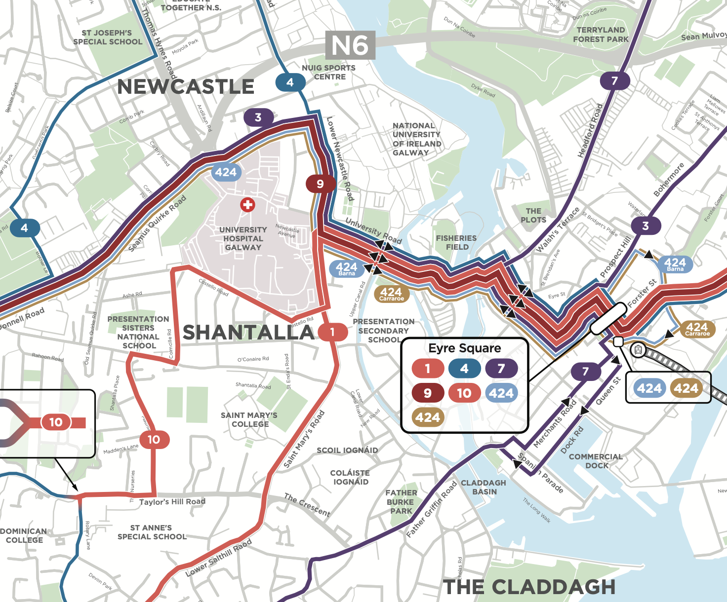
“Decide and Provide”: Transport Modeling That Gives Us Choices

Our whole urban form is heavily shaped by computer models that predict how much traffic a development will generate.  Want to build a small residential-over-retail building in a walkable area?  A conventional model will show that you need lots of parking, but also that you’ll generate lots of traffic on the nearby streets, which will provoke the neighbors to rise up to oppose the project.  Since the model doesn’t think anyone will walk to it anyway, you might as well just build it out by the highway.

Hence, our suburban landscape.

It all goes back to the transport planning ideology called “Predict and Provide.”  When predicting how much vehicle traffic a development will generate (its vehicle trip generation rate) the model looks at what similar developments have generated in the past, and just assumes that will continue.

Predict and Provide model: The future is just like the past. Nothing you can do about it. Source: TRICS Guidance Note, February 2021

If the community isn’t changing, and the world isn’t changing, this might work.  But of course, the very fact that you’re proposing a development means that the community is changing.  It’s growing, which means car-dependence is on its way to hitting known limits where congestion starts to affect behavior. Meanwhile, the world is changing: people want to live in more walkable communities, and there are many incentives to encourage them.  The classic “Predict and Provide” model tells us to ignore all that.  It presumes that you are a copy of your parents and that when you’re their age, you’ll behave exactly they way they do.

Some of us have been pointing this out for years.  The transport modeling industry sees the problem and has been softening its predictive claims, but the fact remains that the biggest investments, large infrastructure and real estate development, require everyone involved to (pretend to) believe predictions.  Even if everybody in a process knows now ridiculous the assumptions are, the easiest thing to do (and often the legally mandated thing to do) is to perform the process.

So it’s great to see the emergence, in the UK, of the “Decide to Provide” paradigm. It is now being recommended by the very people who curate the UK’s dominant transport model, TRICS.  It says that when describing rates at which a development generates traffic, it’s appropriate to have a “vision” scenario showing the most credible optimistic outcome.

Decide and Provide. There are several credible futures. Which one do you want?  Source: TRICS Guidance Note, February 2021

You can”t predict the future, but you can predict a range of credible possibilities, and then think about which one you actually want.

Maybe the trip generation rate will rebound (the “Nationally informed projection”).  Maybe it will continue its slow descent. Or maybe what it does will depend on your vision for your whole community, and your resolve in implementing that vision.  If you want a more walkable community, this model holds open the possibility that you might succeed.

The “vision-based” curve is “supply-led” because it’s based on the widely observed principle (and biological axiom) called induced demand: If you make something easier, people will do it more, and if you make something harder, they will do it less.

The “supply-led” curve is what happens if you limit road space and parking, while making it easier to walk, cycle, or take public transport.  Obviously this has to be done in the right place, where there is already a critical mass of walkable development, or where there’s a viable plan to create such an area at sufficient scale.

Should you seek to shift demand away from driving?  It’s a choice, arising from a set of values.  But “Predict and Provide” was also a choice, expressing a set of values. There never was neutral or factual way to predict trip generation.  There was only a culturally dominant one.

Every time we undermine the illusion of predictability, we expand our freedom to choose!

Do You Really Want to Live in “Perceived Time”?

Salvador Dali, “Profile of Time” Photo by Wikimedia Commons user “Julo”.

As you may have noticed, humans don’t perceive time passing at a constant rate. “Time flies when you’re having fun,” we say, or “the meeting was only an hour but it felt like an eternity.”

This phenomenon has obvious relevance to transportation and urban design.  It’s well established, for example, that a walk seems to take less time if it’s more pleasant.  Countless studies have established this as a matter of human psychology, and you probably also know this from your own experience.

But when the behavior science literature talks about improving perceived time, we should pause before deciding that this is the kind of time that matters.

As a transportation planner who sometimes works with architects, I often have this conversation:

Me:  “If you design it that way, these people will have a 15 minute walk.”

Architect: “But it’s a beautiful walk, so it won’t feel like 15 minutes.”

The architect’s implication is that perceived time is what’s real.  If a walk is so pleasant that it feels like five minutes, then you won’t notice that it’s actually 15.

Well, maybe you won’t, but the people waiting for you will.   If you have to punch a timeclock at work, try telling your boss: “I’m not really late, because my perception of time is that I got here ten minutes ago.”  For that matter, try telling that to the friends waiting to meet you, or to your spouse or child at home.

Perceived time is a crucial dimension of the human experience, and an important source of joy.  Perhaps you have had the pleasure of just wandering, in a city or wilderness, without goal, deadline, or destination. [1] You just walk, drink in the sensations of the place, and when you come to a place where you could go one way or another, you go whichever way feels right, without regard to where you will end up.   But important as these experiences are, they always end in ways that throw you back into objective time.  The sun sets, or a business you need is about to close, or you have to meet someone.

Perceived time can be a great experience, and there’s nothing wrong with it, but it could also be called selfish timeObjective time, by contrast, could also be called social time.  Social creatures cannot all live by their own clock.  It is only by respecting objective time that humans can show up for each other in all the ways that make jobs, friendships, and families possible.

There is an obvious class dimension to this issue.  If you make a trip longer in order to make it more pleasant, you’re imposing delay on people who can least afford it.   When we decide to sacrifice low-income people’s objective time to improve their perceived time, we are measurably reducing their access to the things they need, thus measurably impoverishing their lives.  To avoid these impacts, a logical and just approach to design and infrastructure would first focus on making the best use of people’s objective time, and only then, in cases where objective time is not at stake, work to improve perceived time.

So behavior science thinking is always at serious risk of elite projection.  When someone says that a journey can be longer as long as it feels faster, I always ask, “for whom will it feel faster, and is that the only person who matters?”


[1]  The French call this activity flânerie, and the person doing it a flâneur, a word that has come over into English in literary and urbanist contexts.

People Who Love War Hate Cities

Kyiv in 2022. Kyivcity.gov.ua, CC BY 4.0 <https://creativecommons.org/licenses/by/4.0>, via Wikimedia Commons

People who love war hate cities.

Cities are places where people who are different from each other learn not to fear each other. They find that they can share a public space with people who don’t look like them, talk like them, or act the way they would act, and that it’s almost always fine. People who profit from fear hate that.

Cities produce visibility.  It is easier to not care about poverty or homelessness or the mental health crisis if you see them only on television, but in the city it’s all right in front of you.  It’s easy to believe that those demonstrators are all hoodlums if you’re not on the street with them hearing their actual voices.  In a city there is no avoiding the facts of what a society is, and what its conflicts are.  Cities are where we see each other.  People who don’t want to see hate that.

Cities and their people are vulnerable.  So many people so close together. So easily destroyed by just one disaster, or just one bomb.  So easy for anyone to enter, no matter how hostile their intentions. We don’t have city walls anymore. We have the opposite: Openness and vulnerability are the very form of the modern city. People who feel safe only behind walls hate that.

So lots of people hate cities.  And yet cities are centers of prosperity and opportunity and wealth, so they must be controlled, even by people who don’t much like them.  That struggle to control cities is everywhere: in politics, in policing, in city planning, and when all else fails, in war.

So of course, in time of war, it’s always the city that’s destroyed, and urban people who are massacred. That’s always how it’s been. Cities aren’t just attacked because of what country they’re in, or because of a resource they represent. They’re attacked because of what a city is.


Great News for Chile

Photo: Universidad Católica de Chile

My friend Professor Juan Carlos Muñoz Abogabir is Chile’s new Minister of Transport.  He is a Bus Rapid Transit expert and an eloquent advocate for sustainable and just transport planning, and is also one of the nicest people I know.

Juan Carlos has already been a leader through turbulent times.  In the 2000s was a key advisor to the project that created Transantiago, a government agency managing all public transport in the capital region.  The reform introduced integrated bus service planning and also changed the motivations of bus drivers. I remember riding a Santiago bus with Juan Carlos in the bad old days of 2004:  Bus drivers raced down the street, cutting each other off in hopes of grabbing the passengers at each stop.  And since they made money from taking passengers on but not for letting them off, people sometimes had to jump from the bus as it slowed but didn’t quite stop.

The implementation of Transantiago, however, was a disaster.  When the system was turned on in January 2007, some parts of it hadn’t come together.  Not enough new buses had arrived. Not all the necessary technology was ready. The incentives weren’t quite right.  The result was a couple of months of chaos.  Everyone who touched it, including Juan Carlos, was blamed.  It even affected the President’s approval rating.

Large-scale transformations like Transantiago are to some extent always like this. They were changing an entire sector of the economy over to a new model, in a way that required many people to see their jobs differently. You can flip the switch on a designated date, but people take longer to adapt and there’s always some conflict in the meantime.  In any case, the messy implementation doesn’t mean the reform wasn’t worth doing.  Over time, the biggest problems were fixed, the network began functioning and the anger quieted down.

A few years later, I saw Juan Carlos give a presentation on the Transantiago implementation, and was struck by the tone: He was not defensive at all.  He explained that this was a necessary reform but that Chile’s transport leaders, not excluding himself, had screwed it up.  He knew that failure is a better teacher than success, and he wanted everyone in the world to benefit from their meltdown.

During my 2019 trip Juan Carlos set up a meeting with then-Minister of Transport & Telecommunications Gloria Hutt to talk about my work on access analysis. From left to right: Juan Carlos, yours truly, Minister Gloria Hutt and Vice Minister José Luis Domínguez.

Fast forward to 2019.  The institute that Juan Carlos leads, CEDEUS, was planning a major global conference in Santiago when the country erupted in violent protests. All conferences were canceled, including his, because nobody could guarantee the security of visitors.  I had been booked as a speaker at the conference, but Juan Carlos asked if I would come anyway, and do some events around the edges of the crisis.  So I went, and lacking translation services I did a few presentations in my then-terrible Spanish. I described the experience here.

Obviously Juan Carlos grieved at the way that the social unrest began: a massive act of vandalism against the Santiago Metro.  But he shared the protesters’ demand for change, and he worked to channel the energy toward revealing the injustice of the built environment and transport systems.

So I’m just delighted at this announcement.  Chile is wealthy enough to do things, but its car ownership is low enough that it can still choose to avoid many of the worst mistakes of North America.  And it has the perfect transport leader for the moment.

Dallas: Welcome to Your New Network

The Dallas area’s new bus network goes live on January 24, 2022!  It’s the result of our three-year collaboration with the transit agency DART and its member cities.  The project relied on extensive input from the community, and the Board, about what kind of transit system they want to see.  But it’s still a no-growth network, which means that DART couldn’t add new operating budget.  As a result, it’s full of difficult tradeoffs and not everyone will like it.

You can compare the old and new networks at this cool data viewer that we developed.  Here is the existing network followed by the new network.  Note the frequencies in the legend, without which these maps make no sense.

DART Existing Network (note frequencies in legend)

DART New Network (note frequencies in legend).

In general, it’s fewer routes, longer walks in some cases, but higher frequencies. We’ve also:

  • established more regular timed-transfer patterns among infrequent routes, especially at South Garland and Addison Transit Centers.
  • set feeder routes to 20 or 40 minute frequencies so that they match the 20 minute rail frequency.  This is the main reason that you see relatively little expansion of the 15-minute frequencies (red) but a big expansion of the 20-minute frequencies (purples).
  • substantially expanded the GoLink demand-response program to provide more coverage.  This is a relatively low-cost service for DART, as microtransit goes, because some of the service is provided using ordinary Uber rides under contract with DART.

The result is usually faster access to more destinations.  The average area resident will be able to get to 1/3 more jobs in 60 minutes, which means more access to all kinds of opportunity for all kinds of people.  This benefit happens almost everywhere (blue in this image) (click to enlarge).

… and the benefit is similar for all races, ages and incomes.

Source: DART

The plan was based on the Board’s decision (not mine) to shift the focus of the service slightly toward a ridership goal and away from a coverage goal.  That would have meant service to fewer places, or further away from a few people’s homes, in order to run higher frequencies that produced expanded access to opportunity for most people.  Because the sad mathematical fact is:  Ridership arises from how useful service is to many people, not how useful it is to absolutely everyone.  When we seek to serve absolutely everyone, we’re planning for coverage, not ridership.

But in fact, even though the priorities shifted away from coverage, the final network hardly cuts coverage at all.

None of this means that everyone will be happy.  Network changes are always disruptive to some people’s lives. We make sure every decision-maker to know that before they decide to proceed.

Finally, this is not our plan. It’s DART’s plan based on their conversation with the public, and the decision of their Board.  We facilitated the design conversations and did the analysis, but we didn’t set the policy that led to the network looking as it does.  That’s not an evasion of responsibility.  It’s the key to our whole approach to these projects, which is to defer entirely to the community on questions of priorities, and to never make those decisions ourselves.

We hope your new network takes you to good places.  Meanwhile, we’ll soon be starting work on a happier project to envision an expanded bus network, a little bit closer to what the community actually needs.  So if you’re in the Dallas area, stay involved!

Induced Demand: An Axiom of Biology

Figuring out the relationship between this tweet and this article is left as an exercise for the reader.

Induced demand is the observed fact that if you make something easier to do, people will do it more.  For example, if you create new capacity for cars in a place where travel demand is high, the result is more cars.  If you build more capacity to “fix congestion”, you end up back near the same level of congestion you had before.

After decades of observing this pattern, most people are still reluctant to face what this means.  Part of the problem is that we’re presenting induced demand as an observed discovery, which allows us to quarrel over data, research methods etc.

But induced demand isn’t just an observed fact.  It’s also an axiom of biology.  We are as sure about it as we are of the facts of math.  This means we don’t really need to be doing this experiment over and over, just as we don’t need to keep measuring circles to be sure of the value of pi.

In this context an axiom is a statement that can be taken as true because it is part of the definition of a concept you are using, or follows logically from that definition.  The value of pi is axiomatic because it follows from the definition of a circle, in standard Euclidean space that describes our everyday world.

Now consider the concept of an organism.  It implies that:

  • The thing consumes some resource from its environment, in order to have enough energy.
  • It will expend energy getting this resource.
  • Therefore, it must run a positive balance sheet: The energy it spends getting the resource must be less than the energy the resource will provide.

We humans are organisms, so we do what they do.  In particular:

  • To have enough energy, we seek resources.  Money is a symbolic resource in this sense.  We also have other needs like shelter and security that also require resources.
  • We need to get these things in way that minimizes energy costs.  This is what I mean by easy.

We are mobile creatures, rather than barnacles or oysters, so this pursuit of resources often requires traveling. This means that time is also part of this basic calculation that determines survival.  The time spent pursuing a resource can’t be spent pursuing other resources, or doing other necessary things like sleeping.  So we must minimize our costs in both energy (which includes money) and time, while gaining as much energy (money) as possible.

From this it follows that people will tend to travel in ways that maximize their access to resources while minimizing energy cost (time and money) and danger.  People don’t always do this exactly, but the underlying biological imperative is unavoidable.

This means that:

  • If driving suddenly becomes easier (lower time and energy cost) than taking transit, more people will shift to driving, increasing congestion.  This is why road widening in high-demand places tend to lead to more traffic.
  • If a road widening makes it possible for developers to save money (i.e. energy) by building in more distant places where land is cheaper, they will do that.
  • This process changes the shape of the urban area so that people travel longer distances (due to sprawl) at slower speeds (due to congestion).
  • Therefore the average organism will need to expend more time and energy to reach the same resources it reached before.  (Your job flees from downtown to a distant business park where taxes are lower.  Your grocery store closes because a WalMart opened two miles away where you can’t walk to it, or even walk from the nearest point that a bus could get to.)  The organism will also be exposed to more danger as a result.
  • On average, organisms in this system end up in a weakened state, with a worse balance sheet of energy expended vs energy gained.

The organisms in this story are all trying to harvest more energy than they spend in the act of harvesting.   Even unimaginable aliens on distant planets would do this in the same situation.  So it’s axiomatic that, in the absence of other pressures, road widening in a high-demand area will induce more traffic and more sprawl.

So although road-building departments keep doing the induced demand experiment many times every year, and getting the same results, you don’t need to do more experiments, just as you don’t need to keep measuring circles to be sure of the value of pi.  You can add complexity by taking this into the human sciences and trying to model subtleties of human behavior, but all the resulting insights will be marginal compared to the axiomatic fact that above all, we’re organisms, so we’ll do what organisms do.

Virtual Public Meetings: In Oregon, It’s the Law

Here in Oregon a new law mandates that all public meetings must have a virtual component. It is no longer acceptable to do only an in-person meeting.

This is great news, especially for people who want to have diverse and inclusive conversations about public transit.

In the old world, pre-2020, the default public meeting was in person.  If you wanted to express your view, you had to clear your schedule at the appointed time and travel to a meeting site — which was especially onerous for people who don’t drive. The result was a process that is biased against people who are busy. Most people don’t have the time that in-person meetings require.

When it comes to public transit, there is a direct tension between the interests of busy people — who tend to care about getting places quickly — and those of many people who have spare time.  To take one example, retired people often tell me that they need a bus right at their door, but that it’s fine if it comes once an hour, because they can plan around that.  That’s great for them, but that kind of service is useless to anyone whose day is full of deadlines they don’t control: punching a time clock, getting to class, picking up the kid at daycare.

The only way we get functional, just, and inclusive transit is for people with different needs to listen to each other.  That only happens if everyone has the opportunity to contribute, as they do in virtual events.

The other issue, of course, is that virtual meetings can be civil, because the moderator has tools to cut people off if they are rude, profane, or off-topic[1] or speaking too long. All forms of physical intimidation, however subtle, are also off the table [2]. Those behaviors have become another good reason to avoid public meetings.

The in-person event shouldn’t disappear until we’ve fully replaced it for everyone who really needs it, but the exigences of the pandemic have made far more people comfortable with virtual meetings, and there are a range of ways to reach those who still aren’t.  Oregon’s law doesn’t ban in-person meetings, of course. It just says that a process that’s only in-person is no longer acceptable, because it just excludes too many people. I hope we’ll see this spread far and wide.

————–

NOTES

[1] At a Cleveland meeting a few years ago, where I was presenting about our bus network design project, one lady devoted her three minutes to probing whether I was married, and if not, what I was doing about that.

[2] Then there was the meeting in a Western US city, years ago, where one belligerent gentleman testified while keeping one hand in his pocket, holding a clearly gun-shaped object.

My Most Popular Posts in 2021

Each year I’m interested to see which posts have gotten the most attention. Note: This list shows the most popular post in 2021, not the most popular posts written then. As you can see, many of my older posts remain useful and popular for years.  And if you are just starting to explore this blog, the place to start is the Basics posts!)

  1. That Photo That Explains Almost Everything (2011).  You’ve seen the photo.  I notice a few things in it beyond its first impression.
  2. The Dangers of Elite Projection (2017).  This is one of my most useful posts ever, about a basic mistake that’s everywhere in city planning.  It’s an example of my attempt to talk very patiently and inclusively about a difficult topic that makes people very emotional.
  3. The Power and Pleasure of Grids (2010). An explanation of why grid transit networks are so effective.  This showed up in Chapter 13 of my book.
  4. Basics: The Spacing of Stops and Stations.  (2010).  This turned into Chapter 4 of my book.
  5. Basics: Walking Distance to Transit.  (2010).
  6. Access, or the Wall Around Your Life (2021).  My most important 2021 piece by far, in which I talk about a new way to measure public transit’s success  Glad to see it on top of the 2021 stack. Keep promoting it!
  7. US Commuter Rail: What It Is and What It Could Be.  (2021)
  8. Fixing US Transit Requires Service, not just Infrastructure (2021).  The usual warning about US Federal public transit spending.
  9. San Francisco: A Forbidden Fantasy Comes True (2020).  A minor post about a transformation of San Francisco’s rail network.
  10. The Problem of School Transportation (2017).  Why don’t transit agencies serve schools in just the way they need?  Here’s the answer.

And a few important ones that are just outside the top ten:

A very sensible selection, readers, by you and the publications that linked here!  Honored to have such a thoughtful audience.

Happy New Year.

Transit System Maps Still Matter

A slice of our system map for AC Transit.

A slice of our system map for AC Transit.

As transit information tools have gotten better, some transit agencies have stopped offering a system map to the public.  Often, a website offers me trip planning software and route by route timetables, but not a map.  If it’s there, it’s often difficult to find.

We think system maps are essential.  They’re not just for everyday navigation.  They’re for exploration and understanding.  Some people prefer narrative directions, but many people are spatial navigators, and they need maps.  They’ll understand details only if they can see the big picture.

Another way to think about system maps is that they show you where they could go, and how.  They give you a sense of possibility.  (It’s the informational dimension of access to opportunity.)  Maps also show visually how different services work together.  Finally, good system maps help people make better decisions about where to locate, or even where to build things.

One of our most fun projects this year was a new system map for AC Transit in greater Oakland, California.  You can see the whole thing, including its legend, here.  (To be fair, we’re not the only people who do these. Our friends at CHK America do them, and I also love the work of the European designer Jug Cerovic.)

The style of this map is very similar to that of the maps that we’ve always used in our planning studies.  The key is the visual hierarchy that makes frequent lines more prominent than other lines, and makes all-day lines more prominent than peak-only lines.  (In older standard mapping styles in this region, peak-only express lines were often the brightest red, even though they don’t exist the vast majority of the time. It was very confusing.)

As transit planners, we use this style for all of the maps that appear in our studies.  In fact, red=frequent in absolutely everything we do, whether it’s a map, a chart, a planning game toy, or a pen used to draw routes inside a course or workshop.

We take pride in having been among the first to bang this drum.  I was making the case back the 2000s (really, in the 90s) and there’s a chapter on it in my book.

We’re excited to be in the business of public-facing system maps.  They don’t have to be this precise; they can be done at various levels of design at various costs.

But if a system map doesn’t exist, people can’t understand all that your transit system can do.