We’ve been working with San Francisco Municipal Transportation Agency on the design of the next phase of their service restoration. Read all about it here!
What Should the Criteria for US Federal Transit Funding Be? (They’re Asking You, Now!)
Should proposed public transit infrastructure in the US be judged on whether it helps people go places so that they can do things? The US Federal Transit Administration (FTA) is asking this question right now.
FTA helps fund most major transit construct ion projects in the US. Recently, these programs have doled out about $2.3 billion per year in capital funding for transit projects across the country. The Senate Infrastructure Bill would nearly double the annual funding for these programs for the next five years. If there’s a piece of transit infrastructure you want to see, or one that you oppose, you should care about how the FTA makes its funding decisions.
Congress has defined the criteria that FTA must use to evaluate the projects. But the FTA has broad discretion in deciding how to define the measures for each criterion. So now they are asking you, me, and everyone about how we ought to change or update those measures.
Their questions should make us optimistic about what US transit funding could become. They don’t sound like an ancient bureaucracy going through the motions of public consultation. Instead, the agency really seems to want our opinion about how they should measure the success of their investments, a decision that will directly determine what gets funded and built. Read the questions yourself if you don’t believe me.
Does it matter if we can go places, so that we can do things?
FTA asks many good questions, but one especially stands out.
Should FTA consider ‘‘access to opportunity’’ under the Land Use criterion? If so, how specifically could FTA measure it? For example, should access provided by the project to education facilities, health care facilities, or food stores be considered? Please identify measures/data sources that would be readily available nationwide without requiring an undue burden on project sponsors to gather and FTA to verify the information.
Access is your ability to go places so that you can do things in a reasonable amount of time. Access reframes discussions of travel time: Instead of asking how long it takes to go to a particular place, you look at how many useful places you can go in a given time. In short, we’re talking about access to opportunity, which means not just work or school but your freedom to do anything that requires leaving home.
If you’re not familiar with the concept, please see my full explainer here. But the most important point is that when we increase people’s ability to reach destinations in a shorter amount of time, we are improving ridership potential, revenue potential, climate emission benefits, congestion mitigation benefits, overall access to opportunity, and personal freedom, and we can also measure whether we’re doing these things equitably. Access measurement can help meet all of these seemingly disparate goals.
Access and the Land Use Criterion
When the FTA asks about whether access matters, they are thinking about this in the context of their Land Use criterion. They deserve an answer on this, although they also should hear about how caring about access would affect other criteria they care about, which I’ll touch on further below.
FTA’s Land Use criterion measures how much population and employment is around the stops or stations of a proposed project. The point is to determine that there is enough demand adjacent to proposed facilities. (The criterion is not about the ability to generate future development – that’s under a different criterion, Economic Development.)
This table, from the FAST Updated Interim Policy Guidance dated June 2016, gives you a sense of how this evaulation works now:
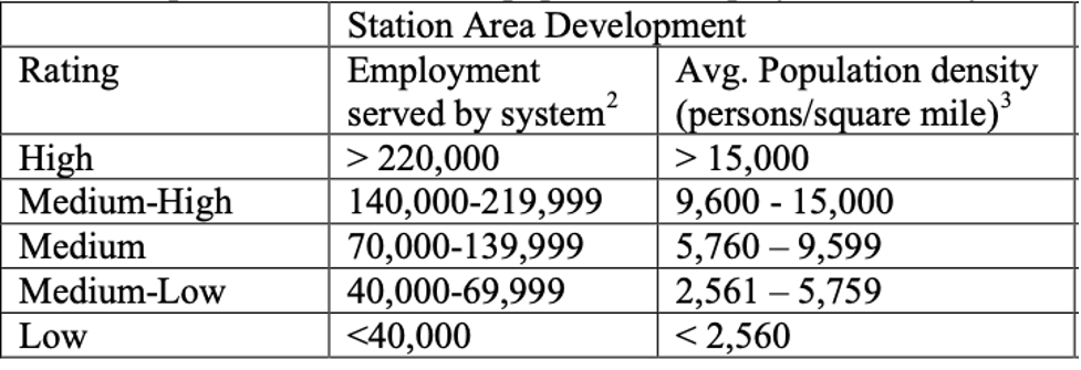
Federal Transit Administration, Final Interim Policy Guidance Federal Transit Administration Capital Investment Grant Program, June 2016. p 15.
A project gets a higher rating if there’s more density around the station, and also if there’s more employment anywhere on the “system”.
But what do they mean by “the system”? Here’s the crucial footnote:
The total employment served includes employment along the entire line on which a no-transfer ride from the proposed project’s stations can be reached.
So all destinations that require a connection are excluded, while all destinations on the same line, even if they are an hour away, are included. In other words, as long as you get to stay in your seat, it doesn’t matter how much of your life you spend commuting. By contrast, if you can get to lots of jobs quickly with a fast transfer, those jobs don’t count in assessing the value of the line. Travel time, and hence access, don’t matter at all!
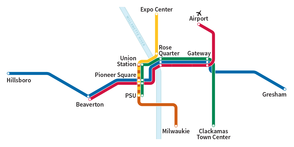
If you have an hour and 40 minutes to spare, you can go from Gresham to Hillsboro without leaving your seat! But should that count as access? Source: Trimet, Portland, OR.
For example, in Portland, where I live, a single light rail line will take you across the region, from Gresham to Hillsboro, in one hour and 40 minutes – far too long for a one-way commute. But under the current method, all the jobs in Hillsboro would be counted as providing value to someone in Gresham, while the jobs that are less than an hour away – on a trip that requires the train and a bus – count for nothing.
So “Employment served by the system” is really just “Employment served by the line” Likewise, the measure gives zero value to populations that are not at stations but that can get to stations easily via connecting buses. In short, the measure excludes all the benefits of actual networks, which are a bunch of lines working together to expand where people could go.
How would an access metric change this approach? Suppose the measure were something like “increase in the number of resident-job pairs that are connected by a travel time of 30 or 45 minutes.”
A resident-job pair is an imagined link between every resident and every job (or school enrollment). Each link represents a possible commute, which is an opportunity that someone might value, now or in the future. The number of resident-job pairs in a region is the number of residents times the number of jobs (or school enrollments). A very big number, but we have computers!
If we measured access in this way, what effect would it have on how FTA evaluate projects?
- It would still quantify the benefit of land use intensification around stations. These areas tend to get the largest access improvement from a project, so that improvement, multiplied by the density of population and jobs, would generate a higher score.
- It would measure what that density achieves for mobility. From a transportation perspective, the value of density around a line is that it provides the line’s benefits to more people, so that more people can get to more useful places sooner. So maybe we should measure what we’re really talking about.
- It would consider land use in the whole area that benefits from the project, not just around stations. It would reward communities that have thought about the total transit network more deeply and made some commitments about it. The tendency to propose a line in isolation, without thinking about its role in a network, is a very common problem in US transit infrastructure.
- It would refer to something that everyone cares about: their ability to go places so that they can do things.
What about equity? The current criteria specifically measure the quantity of affordable housing near stations, and its likely permanence – an important tool to discourage displacement due to gentrification. That measure definitely still matters.
But in addition, you could measure the access experienced by various racial or income groups, and make sure that this isn’t much worse what the entire population experiences. For low-income people, you could look at their links to low-wage jobs and educational opportunities, so that it emphasize the commutes that they are most likely to need or want. This would ensure that every element of the land use pattern is equitable in its most important aspect: the way that it ensures fast access to many opportunities.
Finally, FTA specifically asks whether access to “education facilities, health care facilities, or food stores be considered”. The answer is surely yes, because most transit trips are not work trips. We must measure access to all these things for populations likely to care about them, to the extent that the data permits.
For example, you could construct a database of all resident-grocery store pairs and run the same calculation, probably using a shorter travel time budget like 15 or 30 minutes. You could do the same for healthcare. You could construct a database linking school-age residents to school enrolments, and young adults to university and college enrolments. Retired people could be excluded from the residents-jobs database but included in databases of, say, links from residents to healthcare, food, etc. There are many ways to broaden the diversity of travel desires that a good network needs to serve.
The relative importance or weighting of all these measures would need more debating, possibly based on the size of each market in the region’s travel patterns with some bonus weighting for equity.
But to sum up: When we talk about existing land use as a transportation criterion, what do we really mean? I think we mean that the land use pattern contributes to a transit project’s ability to expand many people’s ability to get to many places in a reasonable amount of time. So let’s measure that!
Access or Prediction? A Broader Question for FTA
Land use is just one of the six criteria that FTA uses, and the one they have specifically asked about. The others are:
- Mobility Improvement
- Cost Effectiveness
- Environmental Benefits
- Congestion Relief
- Economic Development
Except for Economic Development, all of these are built on the same shaky foundation: a prediction of ridership well into the future. Access analysis may help to shore up those foundations, because an access calculation is much more certain than a prediction.
That should be especially obvious during the Covid-19 pandemic. The utterly unpredicted ridership trends of 2020 are just an extreme example of the kind of unpredictability that we must learn to accept as normal. As I argued in the Journal of Public Transportation, we can’t possibly know with certainty what urban transportation will be like in 10-20 years, or how our cities will function, or what goals and values will animate people’s lives.
Still, ridership prediction models generally begin with something like an assessment of access. If a project improves travel time for a lot of possible trips, that’s the starting point for a high ridership prediction. But then, predictive modeling mixes in a bunch of emotional factors that amount to assuming that how humans have behaved in the recent past tells us how they will behave in the future. This is equivalent to telling your children that “when you’re my age, I know you’ll behave exactly the way I do.”
Of course some human behavior is predictable. We’ll still need to eat. But the world is changing in non-linear ways, which means that the recent past is becoming less reliable as a guide to the future. So if we measured access, we’d still be measuring ridership potential, but without all the uncertainty that comes from extrapolating about human behavior, or telling people that you know how they’ll behave 20 years from now.
Here’s how the access concept could illuminate each of the FTA’s criteria:
For the Cost Effectiveness criterion, Congress has required that FTA measure the capital and operating cost of a project and divide that by the total number of trips (predicted by a model) to effectively measure the cost per trip. Since it would take an act of Congress to change this measure, it stands to reason that FTA should be looking to access measures as factors to use for other criteria. However, we should also assess projects based on the increased access provided per dollar expended.
For the Congestion Relief criterion, FTA measures the number of new riders on the project, yet again based on ridership prediction. We know that transit expansion by itself doesn’t solve congestion, just as road expansion doesn’t either. But transit expansion can do very important things much better than road expansion: it can allow for drastically more economic growth and development at a fixed congestion level and improve the ability of those who cannot drive to participate in the life of the community. It does this by expanding the access to opportunity that’s possible without generating a car trip. So, there’s a good role here for access measures as an indirect way to tell us whether a transit project has a high likelihood of providing an option to avoid congestion.
For the Environmental Benefits criterion FTA looks at changes in predicted air pollution, greenhouse gases, energy use, and safety benefits. Most of these factors are calculated based on predicted ridership. So, FTA is building many measures on the questionable assumption that ridership is predictable. Again, we know that greater access tends to mean greater ridership, which means great environmental benefits. Perhaps we need more research to be able to quantitatively tie improvements in job access to environmental benefits. If FTA sticks with its current measures for environmental benefits, it makes the case for using access measures in other criteria even stronger, if nothing else than to provide a wider range of measures that aren’t tied to one modeling outcome.
For its Economic Development criterion, FTA evaluates how likely a project would induce new, transit supportive development in the future by looking at local land use policies. How might access be a useful measure here? It depends a lot on what kinds of real estate investors we have in mind. The real estate business already calculates car access for practically every site they consider. They should be encouraged to care about transit access (and they sometimes do).
To Sum Up
All of the FTA’s criteria are attempting to answer the question “Which of these potential transit projects across the US is the best investment and therefore worth of funding?” That begs the question of what we, citizens of the US, think we value about our investments in transit. Access starts with one insight about what everybody wants, even if they don’t use the same words to describe it. People want to be free. They want more choices of all kinds so that they can choose what’s best for themselves. Access measures how we deliver those options so that everybody is more free to do whatever they want, and be whoever they are.
Should we be investing in projects that score well on predictions of what we think people will do in the future? Or should we be investing in projects that we can geometrically prove will drastically increase the average person’s access to opportunity?
Whatever your view on these topics, now is the time to respond to the FTA’s questions!
Miami: A Revised New Network
Esta página está disponible en español aquí.
In 2019 and 2020, we collaborated with Transit Alliance Miami to help them develop a new bus network for all of Miami-Dade County. In April the Final Plan was published and put out for public comment by Miami-Dade Transit and their survey showed that 89% of people wanted to see the changes implemented! In October 2021, the County Commission approved the plan for implementation.
This is what the existing network looks like:
Existing Network. Colors mean all-day frequency! Purple = 10 minutes or better. Red = 15. Orange = 20. Blue = 30. Green = 60.
And here is the revised network with fewer routes, less duplication, more frequency:
Revised Network. Colors mean all-day frequency! Purple = 10 minutes or better. Red = 15. Orange = 20. Blue = 30. Green = 60.
(This is not our mapping style, by the way. It’s from a tool developed by Kittelson Associates that lets you move a slider back and forth between the two maps, so that you can see how different they are in the same place. It can be a little clunky. Look close for a vertical grey bar and you’ll find you can slide it left and right. If it isn’t working, reload.)
The revisions to the Better Bus Network since April are relatively modest and include adding back some coverage routes in a few places, some extensions and improvements to service on the beach and a few other corridors. These changes are possible because the revised network provides more service than what we originally planned because the County is now proposing to invest in 7% more bus service than the pre-pandemic network!
As we’ve said before, the Better Bus Network as drawn last year wasn’t what Miami-Dade needed, it was what Miami-Dade could afford. It’s great to see political leaders at the County, led by Mayor Cava, willing to invest in more service to achieve better outcomes.
Miami: Una Nueva de Red de Transporte Público Revisada
This page is available in English here.
En 2019 y 2020, colaboramos con Transit Alliance Miami para ayudarlos a desarrollar una nueva red de transporte público para todo el Condado Miami-Dade. En abril, el Plan Final se publicó para recibir cometarios del público. La encuesta mostró que 89% de la gente quiere que se implementen estos cambios!
Aun así, hubo inquietud sobre algunos cambios y la red de transporte público se actualizó con muchas mejoras basadas en el proceso extenso de participación ciudadana ejecutado por la agencia con el apoyo continuo de Transit Alliance. También han tenido conversaciones con la unión para asegurarse crear un plan fiable que tome en consideración a las personas que operarán el sistema todos los días. Miami-Dade Transit y Transit Alliance han hecho un tremendo trabajo con el proceso de participación ciudadana a lo largo de la pandemia para llevar el proyecto a este punto. Pero, aun así, el trabajo no se ha acabado y deberías prestar atención y participar, especialmente si te gusta este plan revisado.
Así es la red de transporte público actual:

Red de transporte público actual. Los colores indican la frecuencia disponible todo el día! Violeta = 10 minutos o mejor. Rojo = 15. Anaranjado = 20. Azul = 30. Verde = 60.
Esta es la red de transporte público revisada:

Red de transporte público revisada. Los colores indican la frecuencia disponible todo el día! Violeta = 10 minutos o mejor. Rojo = 15. Anaranjado = 20. Azul = 30. Verde = 60.
(este no es nuestro estilo de mapa) Es una herramienta desarrollada por Kittelson Associates que te permite mover la barra gris de un lado a otro para comparar los dos mapas. Así puedes ver como son diferentes en un mismo lugar. Si no funciona, recarga la página.)
Las revisiones que se le han hecho a la red desde abril incluyen reintegrar algunas rutas, extensiones y mejoras al servicio en Miami Beach y otros corredores. Estos cambios son posibles porque la red revisada tiene más servicio de lo que originalmente planificamos. Esto es porque el ahora el Condado está proponiendo a invertir 7% más servicio que antes de la pandemia!
Como hemos dicho anteriormente, la red que dibujamos no es la red que necesita Miami-Dade, sino es la red que pueden pagar con los recursos actuales. Es bueno ver líderes políticos del Condado, liderados por el alcalde Cava, dispuestos a invertir en más servicio para lograr mejores resultados.
Si estás en Miami-Dade, por favor provee comentarios. Miami-Dade Transit tendrá una reunión comunitaria virtual el 8 de septiembre a las 6:30pm Eastern. También tendrán “horas de oficina virtuales” a diferentes horas del 9-10 de septiembre para aquellas personas que tengan preguntas. También puedes tomar la encuesta en la página del proyecto para decirles lo que piensas. Recuerda, si te gusta el plan, ¡lo tienes que decir! Demasiado a menudo, la gente que le gusta el plan no dice nada y los resultados de las encuestas hacen parecer que a nadie le gusta.
Finalmente, la red final se lleva a votación final ante el “Transportation Mobility and Planning Committee” el lunes, 13 de septiembre a las 3:00pm y la “Board of County Commissioners” el martes, 15 de octubre a las 9:30am.
A New Bus Network for Alexandria, Virginia
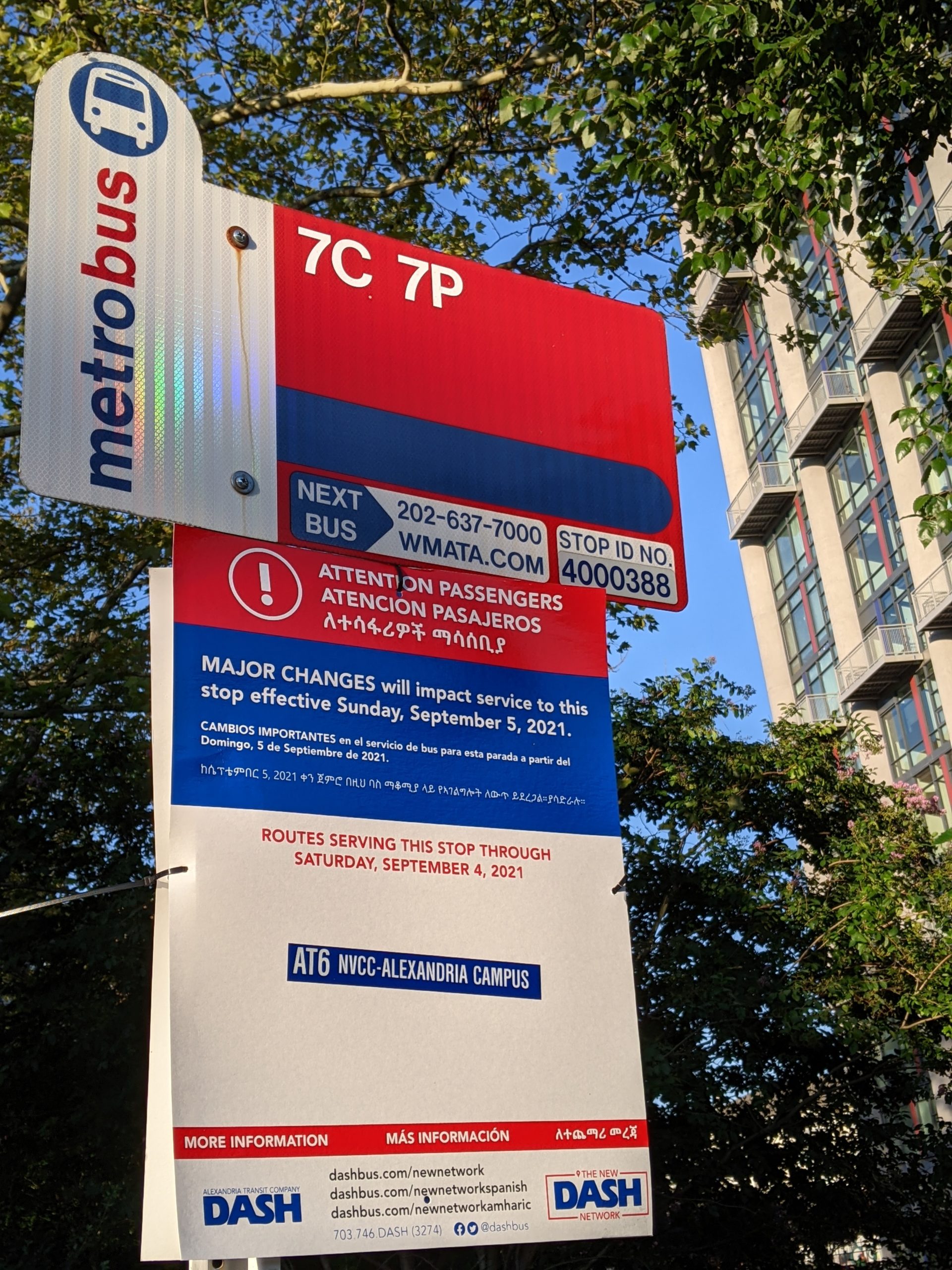
Bus stop with temporary sign displaying service changes
On Sunday September 5, 2021 Alexandria, Virginia will wake up to a new bus system, with a completely redesigned bus network for the City’s transit agency (DASH), major complimentary modifications to the WMATA Metrobus network, and free fares on DASH buses.
The redesigned network in the city is the result of a design process that we guided, in cooperation with the local office of Kimley-Horn, for the City of Alexandria and DASH, and in cooperation with WMATA. The New Network launching on Sunday is constrained by what the City could afford, so it does not increase the total amount of service, but it is just Phase 1 of a ten-year plan to grow bus service in the city to improve service for a growing and densifying city.
Our work with the City, DASH, and WMATA began in 2018, and reached the Draft Plan stage in November 2019. The Draft Plan was designed around the policy direction from the DASH Board that, by 2030, 85% of resources should go toward high ridership service, while the rest should go to coverage service. A major focus of the plan is building up a frequent network by running fewer overlapping and competing lines. That means some trips that a person can make today on one bus might require two buses in the future, but the frequency of service means that total wait time is the same, or less, than today.
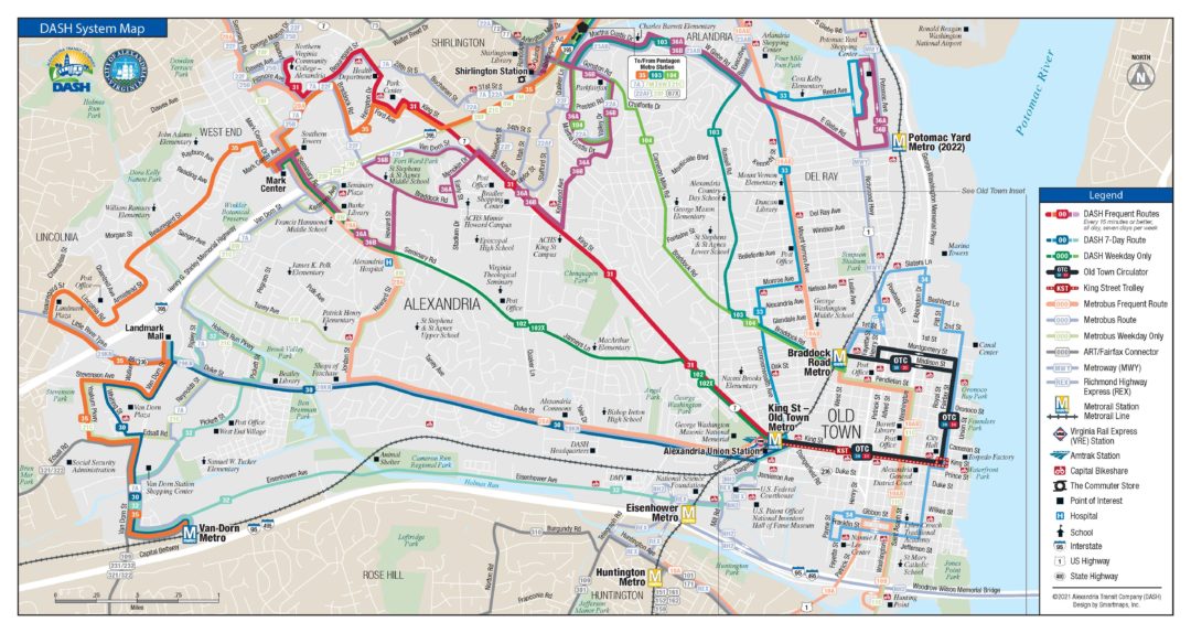
Alexandria VA DASH new system map
While overall response to the Draft Plan was very positive, there were some specific concerns about coverage loss on a few streets and the Final Plan was tweaked to add service back to a few areas at the cost of being less generous with service span improvements in the short term. Overall, the New Network still has major benefits with the simplification of the network leading to faster trips for most people going to most places. You can see how the New Network changes trip times with this comparative trip planner we developed for DASH.
When the Alexandria Transit Vision Plan was completed in February 2020, just before the pandemic, there was significant interest in new investment in improved service in the first few years of implementation. The top priority for new funding seemed to be increasing evening and weekend service. At that time, the plan recommended an 8% increase in service in the short-term that could improve evening and weekend service. Specifically, it could increase the percent of residents near frequent service on Saturdays from 36% to 65% and on Sundays from 15% to 59%.
During the planning process in 2018 and 2019, fares were not considered a major issue. When the pandemic hit, DASH and WMATA, like many agencies, went fare free and that raised the prominence of fares as an issue in Alexandria, as it has in many communities. Since then, the Mayor and many City Council members have decided that free fares are a higher priority than evening or weekend service improvements, and have endorsed increasing the transit budget to cover the $1.5 million annual cost of going zero fare this year.
Throughout the planning process we led the network design and guided the stakeholder conversations. We worked closely with our local partners at Kimley Horn who led the public outreach and key local government coordination. And the City and DASH provided strong leadership throughout and have continued to persevere to bring this first phase to life despite all the challenges of managing the Covid pandemic.
So, thanks and congratulations to everyone at WMATA, DASH, and the City who worked hard to get this done. We hope that everyone who lives in, works in, or visits Alexandria enjoys DASH’s New Network. We encourage Alexandrians to stay involved in advocating for more and better transit, so that the more frequent 2030 Network can be funded and implemented.
San Francisco: Go Forward by Going Back?
We’re currently working with the San Francisco Municipal Transportation Agency (SFMTA), which manages the city’s transit network called Muni, on options for how to develop their network as the pandemic wanes. This piece is cross-posted with the SFMTA Blog.
Source: Wikipedia user Pi.1415926535
When a transit agency comes back from the COVID-19 crisis, should it aim to put service back the way it was, or try to put back something better? That’s the question that the SFMTA will be asking the public later this summer.
Muni started out as a service that took people downtown, and even today, most of the service is oriented that way. Meanwhile the pandemic accelerated ongoing trends that have shifted travel patterns away from a single focus on downtown and towards many locations across the city. So are we sure we want the network to be exactly as it was?
Later this summer, the SFMTA will be sharing three alternatives for how service might be restored in winter and inviting the public to provide feedback on those alternatives. The input received from the public will help the SFMTA Board determine the pattern of Muni service to be implemented in early 2022. The three scenarios the SFMTA will be laying out for the public to consider are:
- Return the Familiar Network
- Build a High-Access Network
- Develop a Hybrid Network, balancing the best features of the first two.
The Familiar Network alternative would put back the routes people are used to from prior to the pandemic. But the service that people are used to isn’t always the service that helps the most people get where they need to go.
The High-Access approach would shift some patterns of service to expand people’s ability to get to more destinations sooner. (See here for a full explanation of how access works.)
When we plan for high access, we aren’t just thinking about trips people are making, or the trips they made before the pandemic. We’re also thinking about all the trips they could make. Better access can mean more opportunities in your life. Right now, many people’s lives are changing as they find new jobs, get their kids started at new schools and explore new types of recreation. A high-access network tries to give people as many options as possible.
What does a high-access alternative mean in practice? Here’s an example from the Richmond District: Once Line 31 Balboa comes back in August, the Richmond district will have frequent east-west lines spaced every quarter mile. But Muni’s 2 Clement runs just one-eighth mile (a long Richmond block) from the frequent lines on California and Geary.
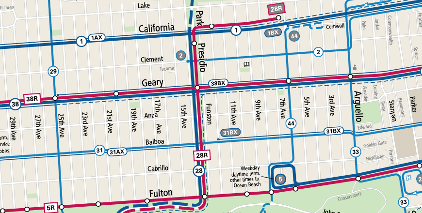
Pre-pandemic map of San Francisco’s Richmond district transit services. Note the consistent spacing of east-west routes every 1/4 mile, but the exception is Line 2-Clement in the upper right. Source: SFMTA
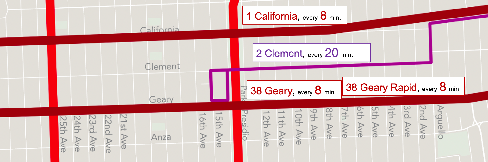
Closer look at Line 2 Clement, and the more frequent lines 1/8 mile away on either side.
To measure the total access for people in a particular place, we look at all the trips to all the places they might be going, and calculate how long those trips take on the network. This travel time includes walking time, waiting time and riding time. In other words, we measure travel time starting from when you want to go, not when the bus comes.
When we calculate access from points along Clement, we find that the 2 Clement doesn’t add much, because the nearby service on Geary is so much faster and frequent. Even if you walk (or roll) slowly at 2 miles per hour, it would take you 8 minutes to get from Clement to Geary. But your wait would be 5 minutes shorter, on average, because the 38 Geary is so frequent. You may save even more time if you get a 38R Geary Rapid, which is faster. At most, the 2 Clement service only saves riders a minute or two. And if you walk at a more average pace, 3 miles per hour, it’s almost always faster to walk to Geary than wait for the bus on Clement.
Such close spacing of parallel routes is not something the SFMTA provides in most parts of the city, so does it make sense to dedicate Muni’s scarce resources to provide it here? Should those resources go where they can measurably expand access to opportunity, such as by moving toward five-minute frequency on many lines?
I’ve talked at length about this high-access approach because it’s less familiar and therefore requires more explanation, but that doesn’t mean the SFMTA has already decided to do it. The choices between familiar and high-access approaches is a genuine question, and we’ll want to know what you think.
Finally, all of these choices are harder because the SFMTA faces severe resource constraints. It still faces a labor shortage and has lost much of its income from fares and parking revenues, not to mention the structural deficit that existed even before the pandemic. So the agency can’t afford to restore all of the service it ran before the pandemic. Even if the labor shortage were resolved (and the SFMTA is working on it), restoring 100% of the previously scheduled service would run the risk that just a year or two later, when one-time federal funding runs out, drastic service cuts would be needed that could leave us with even less service than we have now.
Instead, it makes sense to offer only a level of Muni service that the SFMTA is sure they can sustain, at least until they find new resources to replace funds that have eroded over the last decade and fallen dramatically during the COVID-19 pandemic.
Next, we and the SFMTA will lay out exact plans for each alternative, showing the exact routes and frequencies that each alternative would provide. We’ll then analyze how each alternative affects access to opportunity. We’ll look at this for the whole population, but we’ll also calculate the benefits and impacts for specific neighborhoods, for people of color, for low-income people, and for people who walk or roll relatively slowly.
The SFMTA will bring this information to the community, so that everyone can think about the choices and express their view. This will help the SFMTA Board reach a decision that reflects the values of San Francisco.
Where Flying Cars Take Us: A Science Fiction Excursion
As a transport planner with a strong interest in science fiction, I am obviously provoked by this tweet:
I’m going to keep saying this: a sizeable share of contemporary science fiction is really just bad faith rationales for not building bus lanes.
— Scott Edgar (@scottedgar) March 17, 2019
Scott is talking about flying cars, a staple of science fiction at least since The Jetsons. And as it happens, one of the most fascinating science fiction series of recent years — at least for anyone interested in politics, history, philosophy, or public policy — is about a 25th Century world where automated flying Uber has crushed all other modes of transport, creating a dreaded concentration of monopoly power from which flow the crises that drive the plot.
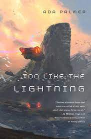 Historian Ada Palmer’s four “Terra Ignota” books, which begin with Too Like the Lightning and will end later this summer with the Perhaps the Stars, tell of a world where globe-spanning flying cars have done away with geographic nations, where “it does not take a firebrand leader to make someone who lives in Maui, works in Myanmar, and lunches in Syracuse to realize the absurdity of owing allegiance to the patch of dirt where babe first parted from placenta.” [p43] Indeed, at 9,640 km/h, you’ll only need an hour to get from your job in Myanmar to lunch in Syracuse, Italy — and a half-hour longer to get to Syracuse, New York. (The people of this world seem to have no concept of sonic booms, presumably for the same reason that fish don’t have a concept of water.)
In place of nations 25th Century earth has organized itself into Hives, non-geographic entities that do much of what nations do. They have governments, laws, shared values, capitals, and cultures, but they don’t control patches of land. You can choose which one to belong to, and still live anywhere.
For my readers who work in city planning or transport, many skeptical questions now jump to mind, so first let me say this: These books are superb. They are funny. They’re erudite but not intimidating, cheerfully explaining the key points of philosophical history when you need to know them. They are driven by brightly sketched and often endearing characters. They bristle with sharp ideas about everything from the enduring appeal of monarchy to the minefield of gendered pronouns. They are especially interested in how societies use and distort the past; this, for example, is a world run by leaders who love an idealized memory of the European 18th Century — the philosophy, the politics, the hoopskirts and wigs — much as the Renaissance (Palmer’s expertise) was built on an idealized memory of ancient Greece and Rome.
This, in short, is what happens when historians write science fiction. We have lots of science fiction where the science is meticulous but the history and culture are thin. These books are the opposite. Here, the technology is lightly and questionably sketched, but the cultural, political, and social consequences of that technology are worked out with stunning detail and plausibility. Even if I doubt its technological premise, this alternative world — one that hasn’t had a war for centuries — was one that I could believe in while I was inside of it.
Still, all of it is built on universal, cheap, and frictionless flying cars. There seems to be no reason not to go anywhere in the world, at any time.

After wondering how anything this energy-intensive could be provided in such abundance that people never discuss its cost, the economist asks: Why would there still be cities? They do exist, and some of them seem to have streets that people walk along, so perhaps people still like being around other people. Progressive urbanists will breathe a sigh of relief when they encounter these scenes.
But most of the cities we visit are capitals of Hives or of other Hive-like communities, and if we’re not there to see powerful people in secret chambers, then we are often there almost as tourists, seeing the sights and savoring the uniqueness and symbolism of the city. Maybe the few pedestrian-filled streets that we see are like those of Colonial Williamsburg or Disneyland. We don’t delve into how the cities function beyond their role as stage sets for the drama. It’s not clear that they function as cities at all.
The city we meet first, Cielo de Pájaros in Chile, is designed to attract vast clouds of birds but lacks commercial districts. It’s a “city designed for for those who don’t like city centers, whose perfect evening is spent by a window, watching gulls and black waves crashing down.” [p31] Clearly if there’s universal Uber there must also be universal Amazon, delivering fish fresh off the dock from your choice of Portugal or Maine, so maybe nobody needs shops anymore. But again, if you don’t like the bustle of human activity, why live in a city? Why not scatter in cabins all along Chile’s coast?
If members of different Hives live side by side while obeying different sets of laws, what law is in force when they interact? For Palmer this is a simple problem of inter-Hive crime, so she images a system of “polylaw” that brings a neutral justice to bear. But a city that functions (rather than just symbolizes) needs a much finer shared web of legal and cultural systems. There must still be rules about where you can land a flying car, or what you can throw in a sewer drain that goes to the local river, or whether you can build a factory next to people’s homes.
In the absence of such rules, we must imagine the libertarian urban world that the unrestrained flying car would make. In the first chapter, even before you meet a child who performs decidedly religious miracles, you will encounter Palmer’s most unbelievable sentence:
Carlyle bade the car touch down, not on the high drawbridgelike walkaway which led to the main door of the shimmering [house], but by the narrow maintenance stairs beside it. [p14]
You can fly across the world on a car that will land on your preferred side of a house, so that you don’t have to walk even a few steps. Later, we even see this done in Paris. Even today you shouldn’t expect Uber to come to your exact address in a dense city, and there will be lots of honking if it does. Bus lanes, bike lanes, pedestrians, deliveries — all these things need space in the street. If a flying car can land in Paris exactly where the customer wants, what does the narrow Parisian street look like? Is there room to walk? What’s left for anything but landing space? 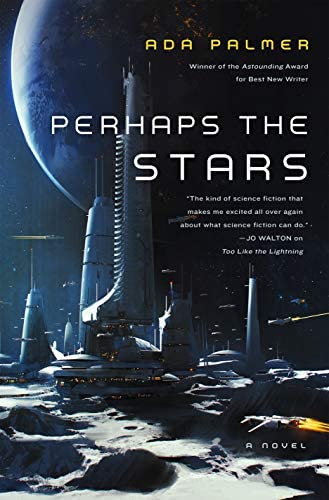
But while city planners may puzzle over these things, Palmer’s books still ask great questions that are at the heart of the question of cities: Are you sure we should want to “abolish geography”, as so many transport gadget inventors have promised over the years? Would you really want to “live in Maui, work in Myanmar, and lunch in Syracuse,” or would you feel that in a world of such universal travel, all these places have become so identical that you might as well work from home? If you did that, would you even go for a walk in your neighborhood, meeting familiar people in the flesh, when you could just as easily walk in a city that’s having better weather at the moment? Will you like a placeless society where you and your neighbor listen to different news sources to the point that you have incompatible views about reality? If so, would you still be able to cooperate about fixing the fence or agreeing on quiet hours? And if that incomprehension got out of hand, then whoa, what would a war between Hives be like?
Whatever your first reaction to those questions, Palmer’s books will add nuance to it. If you enjoy thinking about politics, philosophy, history or public policy (and if you are willing to live without the presumptive atheism of most science fiction) I think you’ll enjoy these books. And I promise: Your skepticism about flying cars will survive the journey.
The Problem with “Improving Transportation”
When you call it that, it’s not very popular.
Looking at this Pew survey, Matt Yglesias points out that Democrats and Republicans seem to agree on the unimportance of improving transportation.
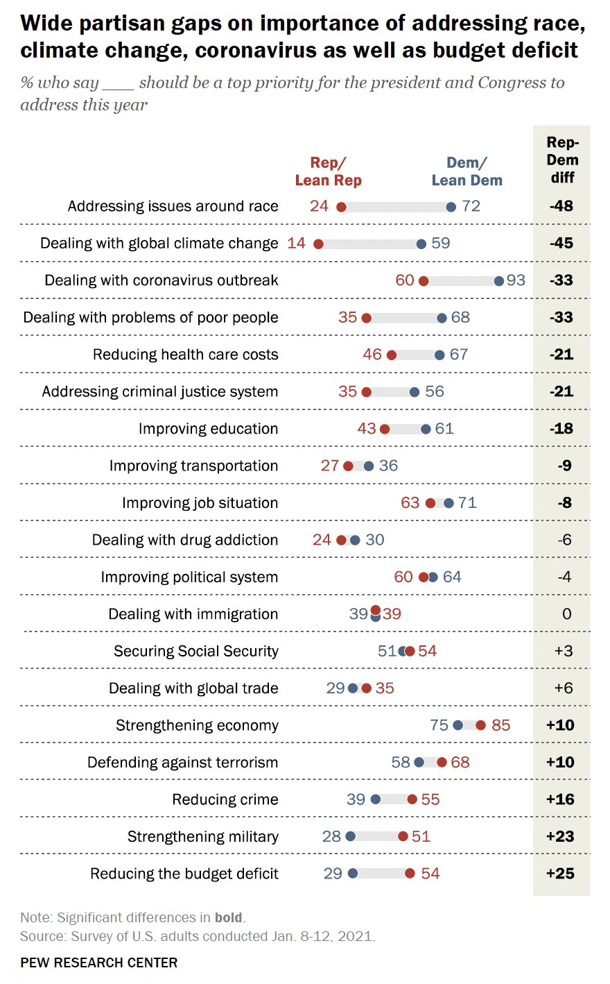
Alas, faced with that, our politicians talk about jobs and infrastructure rather than transportation. This in turn creates the suspicion that we’re employing people to do nothing or building things we may not need.
But of course, many of the things people seem to care most about (and the two parties agree most about) depend on transportation, notably: “Improving job situation.” “strengthening economy.” (It’s also important to several things that are sadly more polarizing, such as “dealing with global climate change,” dealing with the problems of poor people,” and “addressing issues around race.”)
I wish we were in the habit of asking people if they care about “access to opportunities“, which captures why we care about jobs but also resonates with other important goals, like economic growth and access to opportunity.
But in any case, transportation doesn’t poll well. Maybe that’s fine. Even I am not that interested in transportation. I’m interested in people being able to do things, as a result fo being able to go places. Let’s talk about that.
Pedestrian Deaths are an Epidemic
Angie Schmitt, Right of Way: Race, Class, and the Silent Epidemic of Pedestrian Deaths in America. Island Press, 2020.
As a transit planner, I work on creating better networks of routes and schedules that will help people access jobs and opportunity. But a transit agency can’t complete any customer’s trip. To do that, the customer needs to walk. The transit agency can make a nice shelter like the one on the right here, but it can’t change the horror that the customer will face trying to walk to their destination, or to cross this street (9 lanes, half a mile from the nearest signal) to get to the bus in the other direction. That curb lane is marked as a bus lane if that makes you feel better.
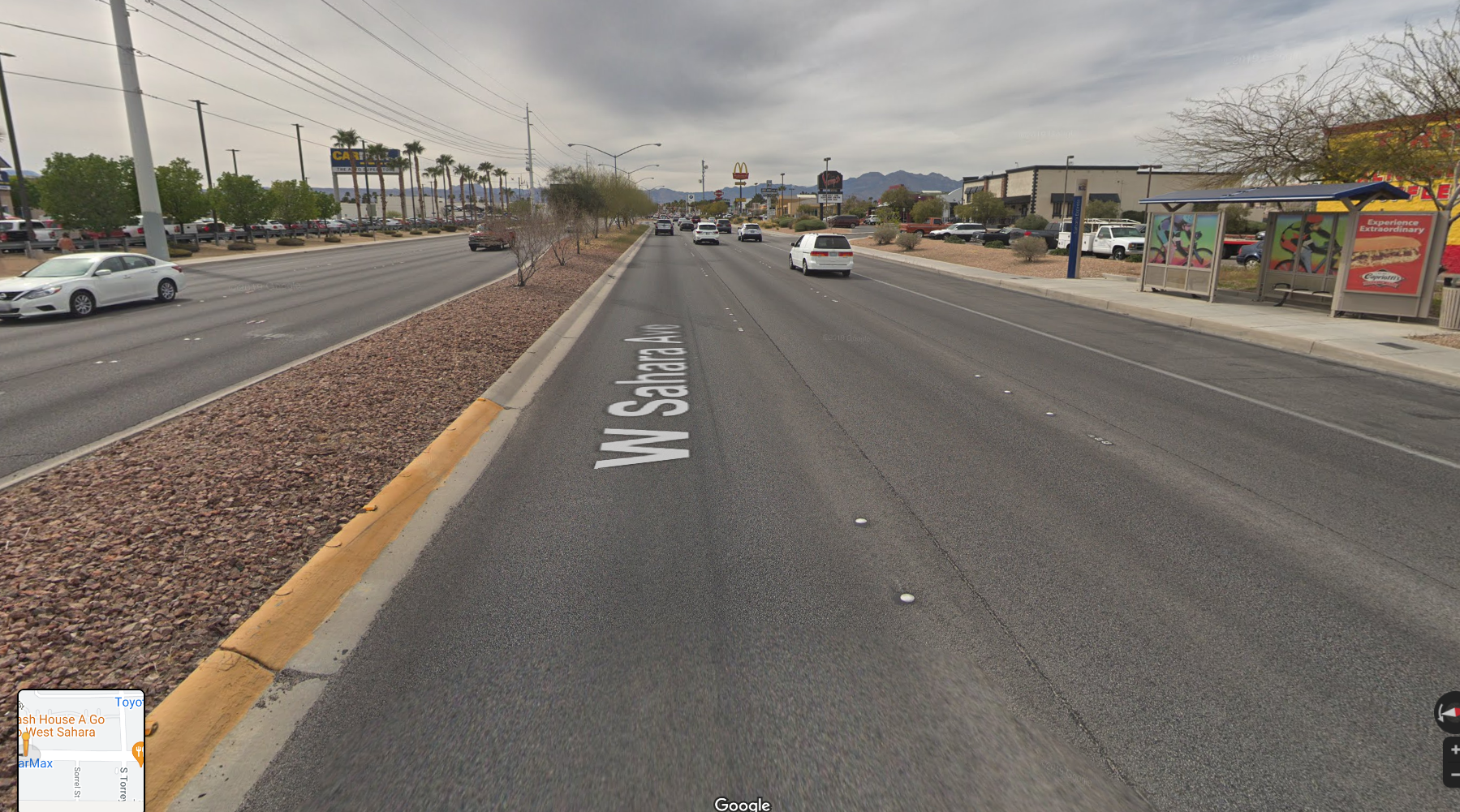
This picture happens to be Sahara Avenue in Las Vegas but as every American knows, it is utterly ordinary. This is the standard suburban street, mass produced around every US city according to manuals that prioritized traffic flow over all other aspects of human life — manuals that are still widely used today.
 When I started my transit planning career in the early 1990s, we faced this kind of suburban street but the stakes were usually lower, because transit wasn’t carrying huge volumes of people to these places. Most of the ridership in major metro areas was in the relatively walkable pre-war inner city. But all that’s changed for the worse. Today, in many US transit agencies I study,some of the highest ridership bus services are on these suburban arterials. People who need transit are forced to live and work in these places, so they have no choice but to dash across those nine lanes, if they are fit enough to dash. My father, in his 70s, used to have to cross a street like this one to catch the bus. He couldn’t dash. He could only hope.
So the fact is shocking but shouldn’t be surprising: compared to ten years ago, 50% more pedestrians are dying after being struck by vehicles — a growing tide of death and mutilation that Angie Schmitt rightly calls a “silent epidemic.”
To clear the space for discussing real causes, Schmitt starts by rejecting the dominant culture’s impulse to blame the pedestrian, which started with the invention of the crime of “jaywalking” almost a century ago. She cites the most obscene examples of victim-blaming, such as the case of Raquel Nelson, a Georgia woman who was prosecuted for the death of her own young son because they had attempted to cross the street together. But she rightly focuses more on the pervasive language choices made by journalists, law enforcement, and other officials that tend to exonerate the motorist no matter what the facts are. Controversially, she even challenges the pervasive “distracted walking” campaigns as an example of setting up public perception to blame the victim. I have mixed feelings about this, because pedestrians gazing into their phones do sometimes step directly in front of buses and trains, but there’s no question that distraction is too easy an accusation in most cases. Crossing the suburban arterial most pedestrians are too terrified to be distracted. My father was not distracted when he set out at 2 mph across a river of traffic going 60 mph. He was simply helpless.
Technology won’t save us, and if it only caters to our urges it could make things worse. Schmitt calls out the trend toward larger and higher-riding cars that make it harder to see a child stepping into the street. In one of the most interesting chapters, she takes apart the various claims of the “driverless” car industry. She sees value in many of the new technologies that alert drivers to hazard, and that could include automatic braking, but of course, much of this technology just opens up new opportunities for human stupidity, greed, and sloth. As the vision of a truly driverless car recedes, we may be looking at a permanent state of partial automation, where the driver must be absolutely alert and ready to act at any moment despite having nothing to do. Maintaining this state of hypervigilant boredom is a superhuman task. People who study meditation for decades may finally get close to it. But when Uber hired people to ride in its driverless test cars and watch for trouble, they didn’t hire or pay for those skills, so when one of their cars killed Elaine Hertzberg, the employee in the car was looking at their phone.
Finally, Schmitt rightly brings the focus back to road design and enforcement. A chapter called The Ideology of Flow looks at how and why streets have been designed on the principle that traffic speed simply matters more than the safety of pedestrians. Here she must take on the Manual of Uniform Traffic Control Devices (MUTCD) an excellent example of the principle that the most controversial ideologies are often hidden in documents whose titles promise that they are utterly boring and irrelevant. MUTCD presents itself as a reasonable set of guidelines to ensure that if you drive from one state to another, the stop signs won’t look so different that you won’t recognize them. But it also contains strong moral statements about the value of human life, such as when it says that a crosswalk should be built only if 93 pedestrians per hour are crossing, regardless of how many people are dying. (This should also recall Brent Toderian’s maxim: You can’t judge the need for a bridge by counting the people swimming across the river.”)
Right of Way is clear, direct, and easy to read. Like a good journalist, Schmitt has strong feelings about this but doesn’t lead with them. Instead, she lays out facts and stories and lets you have your own feelings about them. Ultimately, this book invites the reader to think about the value of human life when it conflicts with our need or longing to go places quickly. Different people may have different perspectives on that, but after reading Schmitt, most will be shocked at just how extreme the epidemic of pedestrian death has become, and what simple things could be done to stop the killing.
US Commuter Rail: What it Is and What It Could Be
 Jake Blumgart has a superb piece in Governing (free but click “Continue to site.”) about the distinctly North American artifact called commuter rail, and why it’s so different from the way heavy rail infrastructure is used for transit in most other developed countries.
The key difference is that most other countries want their heavy rail services to be useful all day, while the default in most of the US has been to run only at rush hour with at best minimal service the rest of the time, as though the briefcase commuter is the only conceivable customer.
There are not such sharp contrasts between regional rail and the rest of transit systems in most wealthy European or East Asian nations. But in North America, the divide was sacrosanct. As recently as 2016, then-MBTA General Manager Frank DePaola drew a bright line between this service and the rest of the agency’s subway, bus, and light rail services: “Commuter rail is commuter rail. It’s not transit. It’s designed to bring people into the city in the morning and take them home at night.”
The COVID-19 pandemic, however, calls that whole concept into doubt.
“It’s not transit.” “The divide was sacrosanct.” Of course this division of the market by trip purpose also implied a distinction of social class, manifested especially in very high fares. But high ridership is diverse ridership. If the goal is to help everyone go places, it’s always best to design services that are useful to everyone and make those services connect, rather than run two systems side by side (commuter rail and slow buses, for example).
Commuter rail services also tend to run long distances across core cities without providing much relevant service to them. They either run nonstop or offer a frequency that’s too low to be relevant for the shorter in-city trips happening along the line.
I have my own trauma about this, because I spent too many years in the 1980s trying to advocate for an all-day frequent service on Caltrain, the commuter rail line between San Francisco and San Jose in California. Caltrain has the geography of a frequent all-day rapid transit service: it runs through the historic downtown of almost every city it serves, because the downtowns grew around the rail line. In terms of the useful transit provided, it could have functioned as another BART line.
Yet decades later, Caltrain service levels are still terrible in the context of the corridor it serves. It was big event when the midday frequency was improved from two hours, as it was in my day, to one hour, but that still makes it irrelevant to most trips along the corridor, especially those of less than 10 miles or so where waiting time becomes more onerous. So a bus system has to run alongside it, inefficiently serving some of the same trips that rail could be serving, and unable to efficiently feed the rail line very well because of the rail’s low frequency and erratic schedule.
Since then, as a bus network planner, I’ve encountered the same problem in many other cities. There’s just no way to integrate commuter rail with a local bus network, because good bus networks involve regular patterns of frequency that are not what US commuter rail does. At best you have to provide dedicated shuttles that meet the trains, and that’s a form of duplication that leads to worse access for everyone.
Blumgart’s piece touches on the effort that’s now being made to rethink commuter rail to make it more like what it’s always been in Europe, East Asia, and even low-density Australia and New Zealand. In all these countries, rail is how you travel longer distances across the region all the time, not just at rush hour.
That difference arises in part from a different geography of social class. When I lived in Sydney, I wasn’t happy with midday frequencies on the all-day rail network — mostly every 30 minutes then, mostly 15 now — but that was far superior to what most big US cities are used to. The difference is the suburbanization of poverty, which has been happening for decades in Europe and Australia but is only now accelerating in the US. The most remote parts of Sydney are some of the poorest. In this urban structure, lower income people have to travel longer distances, but mostly to non-peak jobs. Making heavy rail services part of the total transit system isn’t just a better use of infrastructure, it’s increasingly going to be an equity issue.
If Covid-19 causes a permanent drop in rush-hour commuting, we could see a golden opportunity to make better use of all the existing infrastructure of commuter rail. There are plenty of obstacles, but they aren’t physical. They’re mostly cultural issues embedded in regulation and labor practices. When it becomes important enough, those can be solved.