 Following up on this post about the Northern Ireland public transport situation, I was interviewed recently by John Campbell as part of a BBC program on the topic. I’m right at the beginning, and my part runs for about 10 minutes. Hope you enjoy. It’s here.
General
Ricky Angueira: A “Top 40 Under 40”
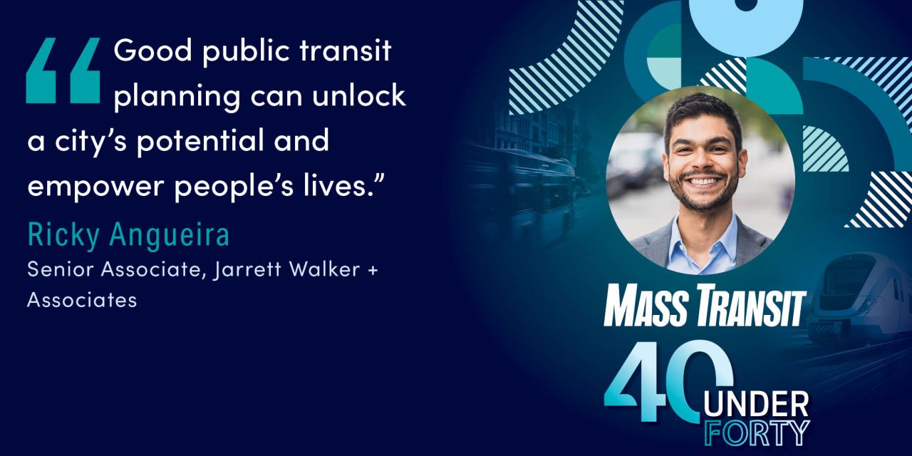 I have mixed feelings about the whole system of awards that runs through the public transit industry in the US, but it’s still nice to see real excellence rewarded. My colleague Ricky Angueira showed up on Mass Transit Magazine’s list of leading young professionals, their “Top 40 Under 40.” This award begins with a nomination from one of our clients, not from us.
Since joining our Arlington, Virginia office in 2019, Ricky has become a valued project manager and service planner. He managed our recent network plans in Williamsburg, Virginia and Knoxville, Tennessee, and also led the analysis team for our complex work on service restoration priorities for San Francisco MTA in 2021. He’s become adept at all the aspects of a network plan, including navigating the local politics of each community.
Ricky also leads public-facing network maps for our clients. He managed the design and creation of maps in Miami, Boise, San Juan (Puerto Rico) and now San Antonio, and is now starting a similar project in Cambridge, UK.
Finally, as Scudder Wagg takes over as President of our firm, Ricky will be the new manager of our Arlington office. It’s great to see this recognition of one of our leading talents.
Louisville: Service Concepts for a Financial Crisis
by Scudder Wagg
Louisville, Kentucky is the largest city in Kentucky and one of the faster growing regions in the state for the last decade. On the border between North and South and on the Falls of the Ohio, Louisville has long been a crossroads of the country and a major transportation hub. Today it is the home of a major UPS hub and has a burgeoning tourist industry focused on the local spirit: bourbon. Since 1974, Jefferson County (now merged into Metro Louisville city) has had a dedicated funding source for transit, to support the regional agency: Transit Authority of River City (TARC).
Unlike other communities that have sprawled significantly, Louisville maintains a busy and dense downtown with its main community college campus and two major medical centers in the larger downtown area. Yet, while the region has grown significantly in the last 30 years, it has grown more horizontally than vertically in that time. This has created a long-term challenge for TARC: its service area has grown horizontally faster than its financial capacity has grown. This long-term trend led TARC into a challenging situation even before the pandemic. Its operating costs were exceeding its operating revenues, so it had a structural operating deficit for a decade before the pandemic. During the pandemic, federal funding helped TARC fill the structure deficit and mostly maintain its network. Now, like many agencies, TARC is approaching a “fiscal cliff” as Covid relief funds run out, operating costs go up due to the difficulty of hiring workers, and pre-pandemic fare revenue aren’t returning.
Without additional revenue, TARC is facing the possibility of cutting service levels by 50% relative to the Spring 2024 Network. TARC has already started cutting service, dropping back its weekday service to Saturday schedule of service on many routes as of June 30. But these cuts are modest compared to what’s coming if new funding can’t be found.
Our firm is helping TARC and its partners around the region consider how the transit network can change under these circumstances. TARC doesn’t want to shrink, and we certainly don’t envy their situation, but TARC has no authority to raise revenue on its own. So, the best that we and TARC can do is to clearly show what’s possible and ask the community and its leaders to tell us what they prefer.
To clarify what’s possible we have drawn three concepts to show what a future TARC network would look like. Two of those concepts are constrained to the projected revenues and require a 50% cut in service. The third, the Growth Concept, shows what could be achieved with a redesigned network and additional investment that allows TARC to grow service by 12%.
Ridership and Coverage Concepts if There Are No New Revenues
If TARC does not receive additional funding, it will have to cut service 50%. This will require a difficult tradeoff between competing goals of ridership and coverage. To illustrate this, we’ve provided two network concepts:
- The Ridership Concept focuses on providing frequent service on the areas that are more likely to use transit – where there are more people and more jobs. It keeps service focused on frequent corridors in the densest, busiest parts of Louisville, but also covers a much smaller area than today’s network. By keeping 15-minute and 30-minute service near most existing riders, this network would maintain reasonable access for most users of the existing system, and therefore maintain ridership to the maximum extent. However, some existing riders are in the low-ridership area, and they would have no service.
- The Coverage Concept focuses on maintaining the existing amount of coverage and provides some level of transit service – although at greatly reduced levels – to most of the area. Nearly all routes in the network would be hourly or worse in this network, so far fewer people would find service useful. Therefore, many existing riders would likely try to find alternatives, and few people would choose to ride this network.
As always, these are two ends of a spectrum, and not an either-or choice.
When looking at the maps, be sure to notice the colors, which indicate all-day frequency. Red means service every 15 minutes all day. The frequency colors are explained in the legend.
Here is a map of the Spring 2024 network (the one we are treating as existing for the purpose of our analysis) and maps of the two constrained Concepts.
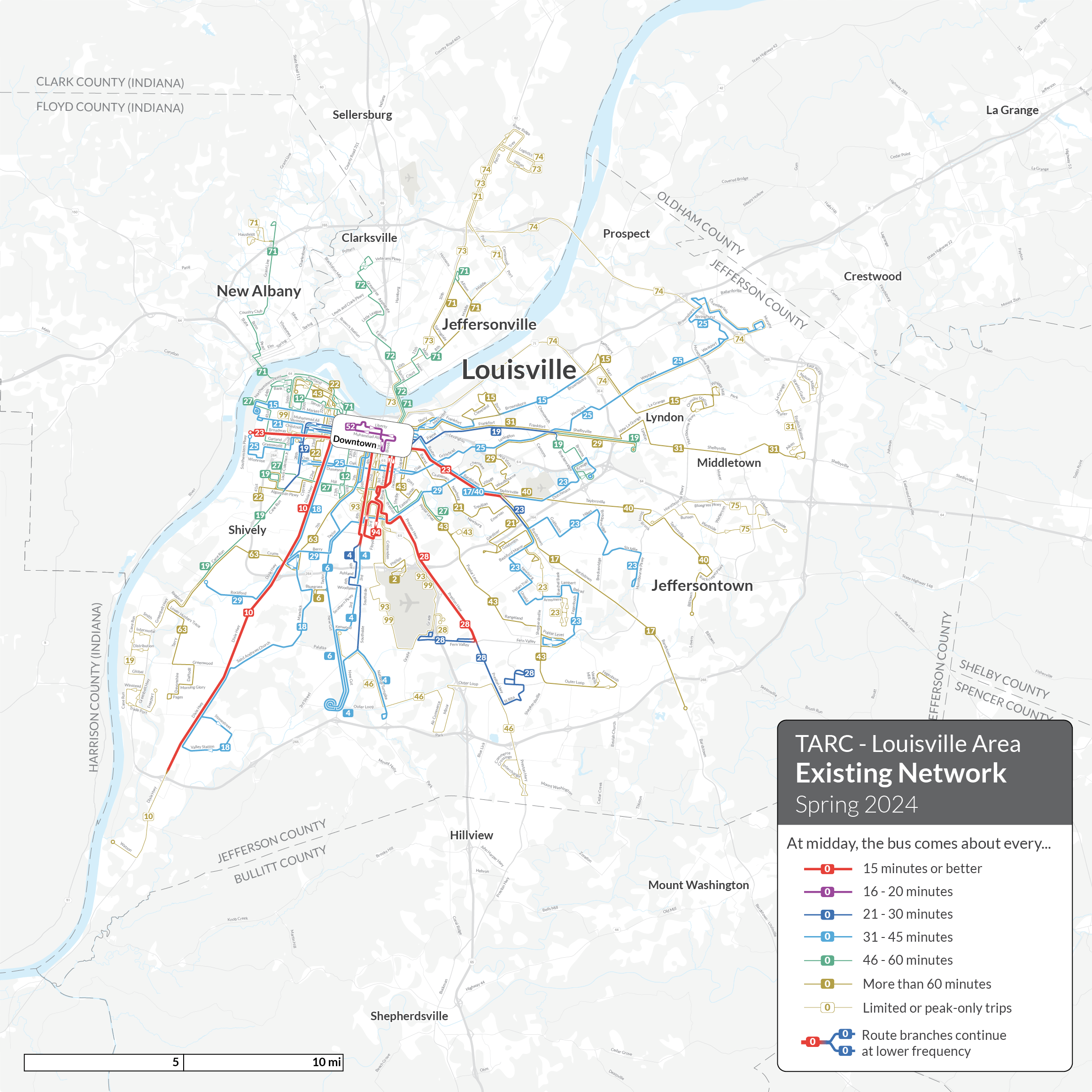
The system as it was in Spring 2024, which we are treating as the baseline although some changes have happened since then.
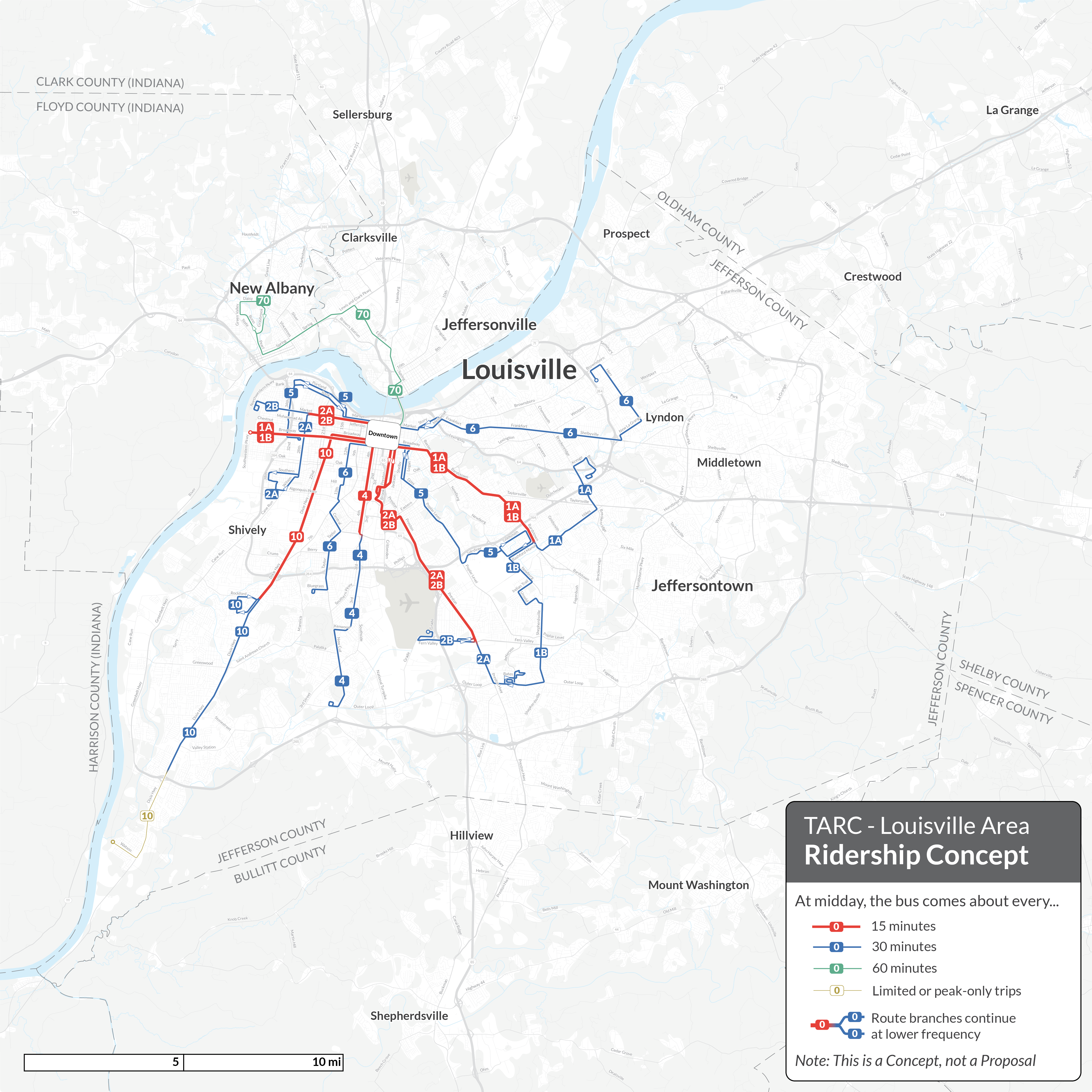
Ridership Concept: If there are no new revenues and TARC must take a 50% service cut, here is what would be left if the goal were ridership. This concept deletes all service where ridership potential is low due to the development pattern, while protecting frequencies in the dense and walkable areas where ridership potential is highest.
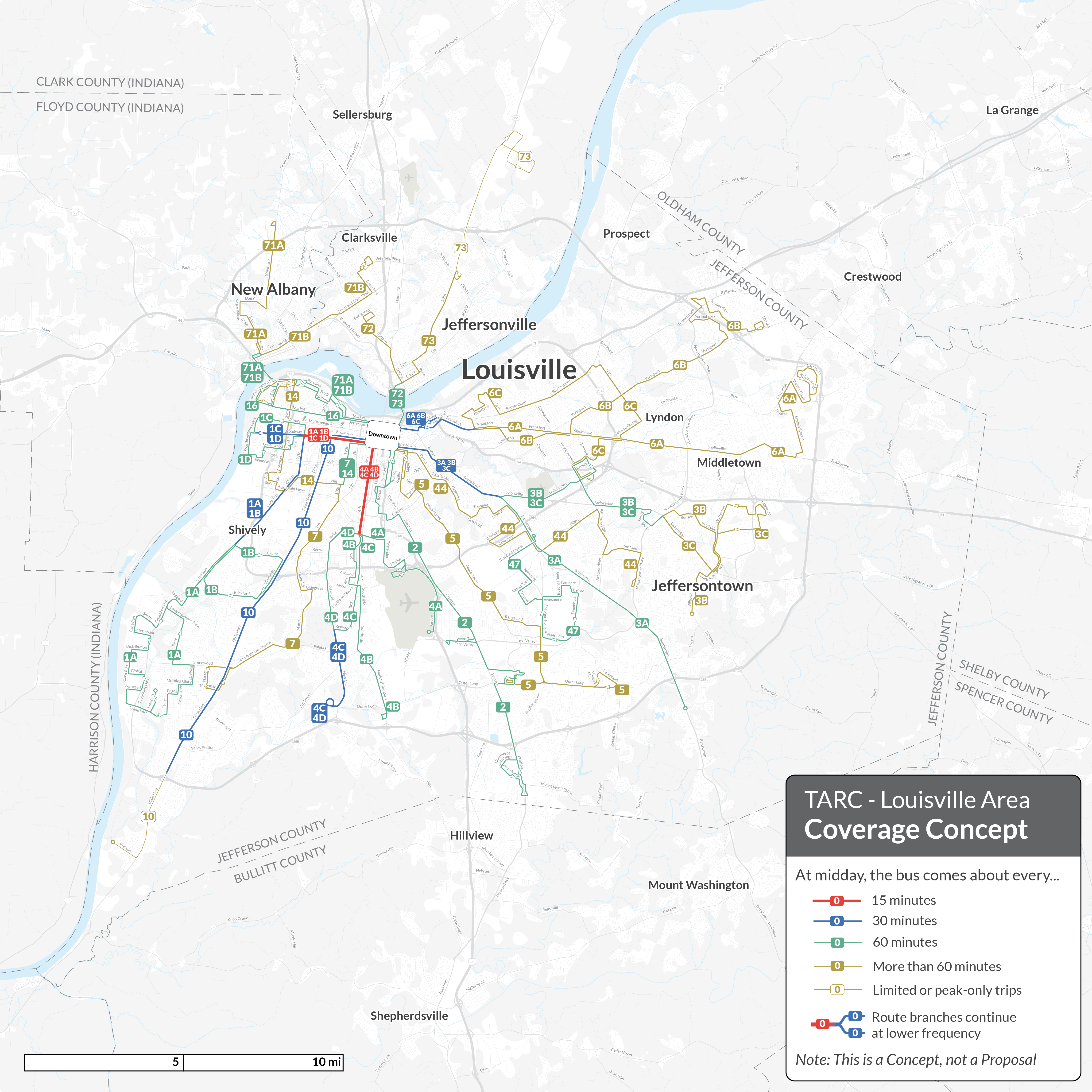
Coverage Concept: If there are no new revenues and TARC must take a 50% service cut, here is what would be left if the predominant goal were coverage. The Coverage concept retains service almost everywhere but at the cost of much worse frequencies.
Growth Concept: New Revenues
The Growth Concept shows what TARC could look like if the community can find additional funding to grow service levels and is willing to accept a big change in the network. It maximizes service in areas of high ridership potential and maintains most of the existing coverage. It also adds features to the network, like more cross-city connections, suburban transit hubs, and new routes in growing areas. This concept shows what Louisville transit would look like if TARC prioritized meeting more of the unmet transit needs of the community and could invest to position the system for future growth.
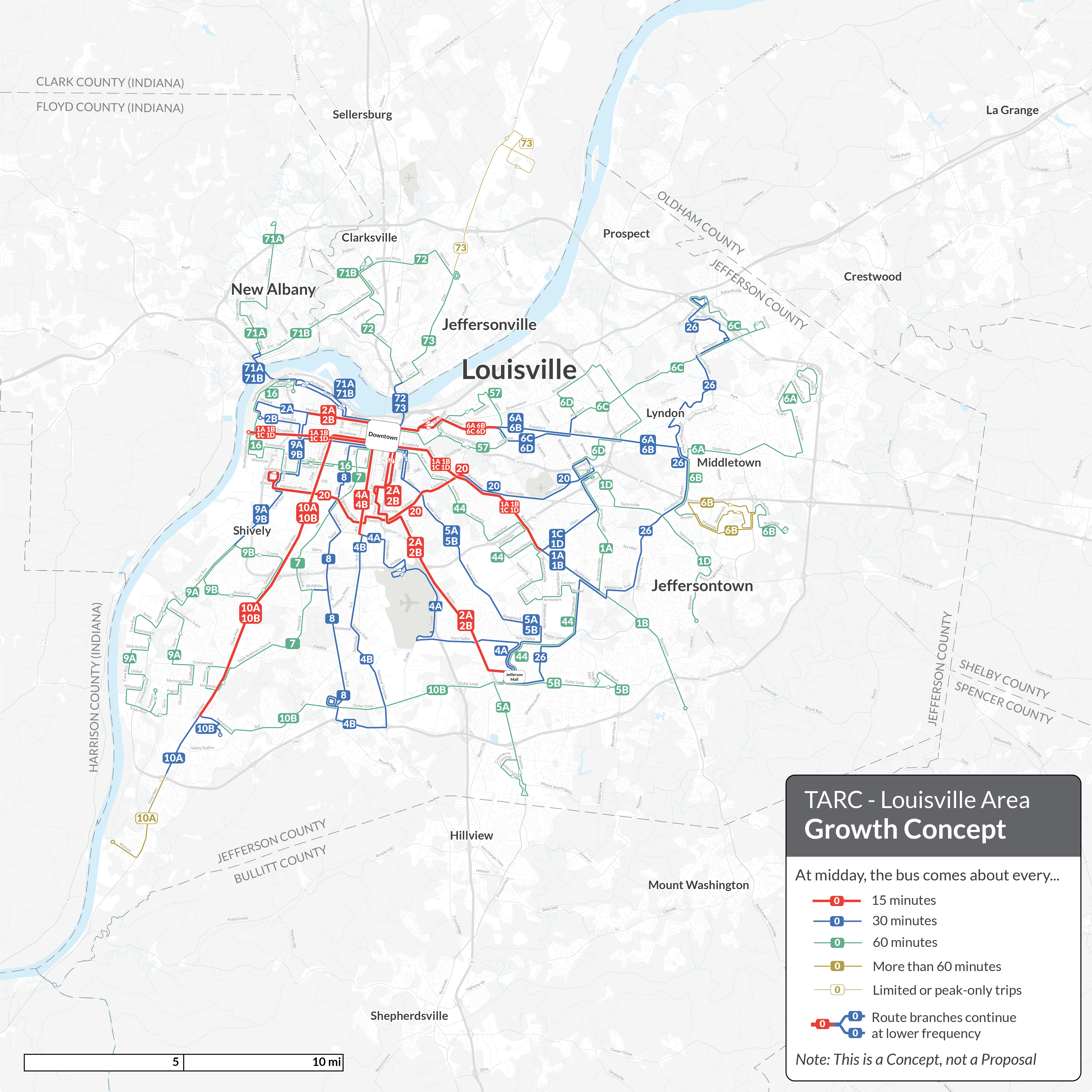
The Growth Concept shows what could be achieved with a 12% growth in service, as opposed to a 50% cut. This would require substantial additional funding for transit service, but would keep service at a level typical for comparable US cities.
The online survey is out now, and TARC staff and the project engagement team will be seeking in-person input at several events through August and September.
We often frame transit conversations around a ridership-coverage trade-off, instead of starting with recommendations. That framework is particularly relevant in this challenging and unprecedented situation for TARC. No one in Louisville has had to imagine such a massive change for transit as a potential 50% cut in service in the past, so it demands a complete shake up of the network to do the best that’s possible within the resources available. Of course, what’s best depends on the community’s priorities, which is precisely why these concepts can help everyone think clearly about their own goals for transit in Louisville.
If you know anyone in the Louisville region, send them to the project website so that they can explore further and provide their input on the Concepts. We also encourage people to read the our two reports (Existing Conditions and Concepts Reports) that detail existing conditions, these Concepts, and the outcomes of the conceptual service changes and the choices that shape transit networks.
Scudder Wagg is President of Jarrett Walker & Associates and is the Project Manager of our Louisville work.
A Presidential Transition
On August 1, 2024, I will cease to be the President of Jarrett Walker + Associates. I founded the firm and hired its current senior managers, but now it’s time for me to step back. Scudder Wagg, who has led our Arlington, Virginia office since its inception six years ago, will be our new President.
Our clients and collaborators probably won’t notice a big difference. The eight owners of the firm are also the senior staff, so the senior team that reports to the President is also the Board to which the President reports. We also take pride in having no external owners or investors looking over our shoulders. All this means that even as President I’ve been more of a coordinator, making big decisions only once it was clear that we had a consensus.
But Scudder is a better manager than I am, so I’m sure many things will improve. Over the last few years, people have occasionally asked me if I would apply for various CEO positions as they came open at public transit agencies. I was flattered, but I know that management isn’t my strength. I don’t really like being in power. I don’t like how people behave toward me when they see me as a power figure. I’d rather be the advisor than the executive.
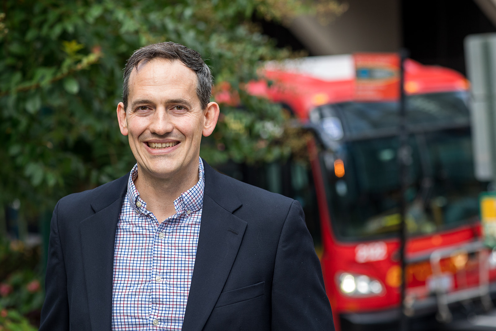
New JWA President Scudder Wagg
So now I’ll get to do that. I will continue to be the lead planner on our biggest network design projects, and I’ll continue to teach and write. I am 62 now and expect to continue working part time for at least several more years. I look forward to many more great collaborations, and to spending less time thinking about management. Scudder will do a great job.
Chicago Area: Rethinking Both Pace and CTA

As the State of Illinois launches a complex conversation about how to fund public transit into the future, our firm has been doing planning work with two of the three big agencies in the Chicagoland region: Chicago Transit Authority (CTA), which mainly covers Chicago, and Pace, which covers almost all Chicago suburbs. I thought it would be a good time to share thoughts from both of those projects.
Recently, I listened to a big State Senate Transportation Committee hearing in which all of the agency heads in the region spoke. The key issues facing the region are:
- a “fiscal cliff” which threatens all the agencies in 2026, as Covid relief funds run out, operating costs go up due to the difficulty of hiring workers, and yet pre-pandemic fare revenue can’t be expected to return.
- a proposal to consolidate the three agencies (Pace, CTA, and the regional rail agency Metra) into one giant agency, supposedly to save money or achieve efficiencies.
To help with these debates, I want to lay out my view here why the agencies need more funding, and why I think consolidation would be a bad idea.
Why the CTA Needs More Money
We just completed a Framing Report for Chicago Transit Authority’s Bus Vision Project. We put a big effort into this report because we wanted to create a sample of all the things we could do, especially in access analysis, to illustrate exactly how a transit system functions and how it addresses various goals.
The report took a long time to write and was somewhat overtaken by events: You’ll notice that it mostly describes the 2019 network, and then more briefly describes what’s happened since then. As CTA recovers from the pandemic-related hiring crisis, the 2019 network is not exactly what it should go back to, but it still represents the most recent “non-crisis” state of the network, so it’s a good point of reference.
The report’s most important point is that Chicago’s geography creates a tradeoff between the goal of ridership and the goal of equity, because Chicago has a large low-income and racial minority population living in especially remote parts of the city, often at low densities or in areas with other physical barriers to service, where service to them is expensive per person to provide. This geography has a history of course, often tied to racist policies and practices that were common in the past.
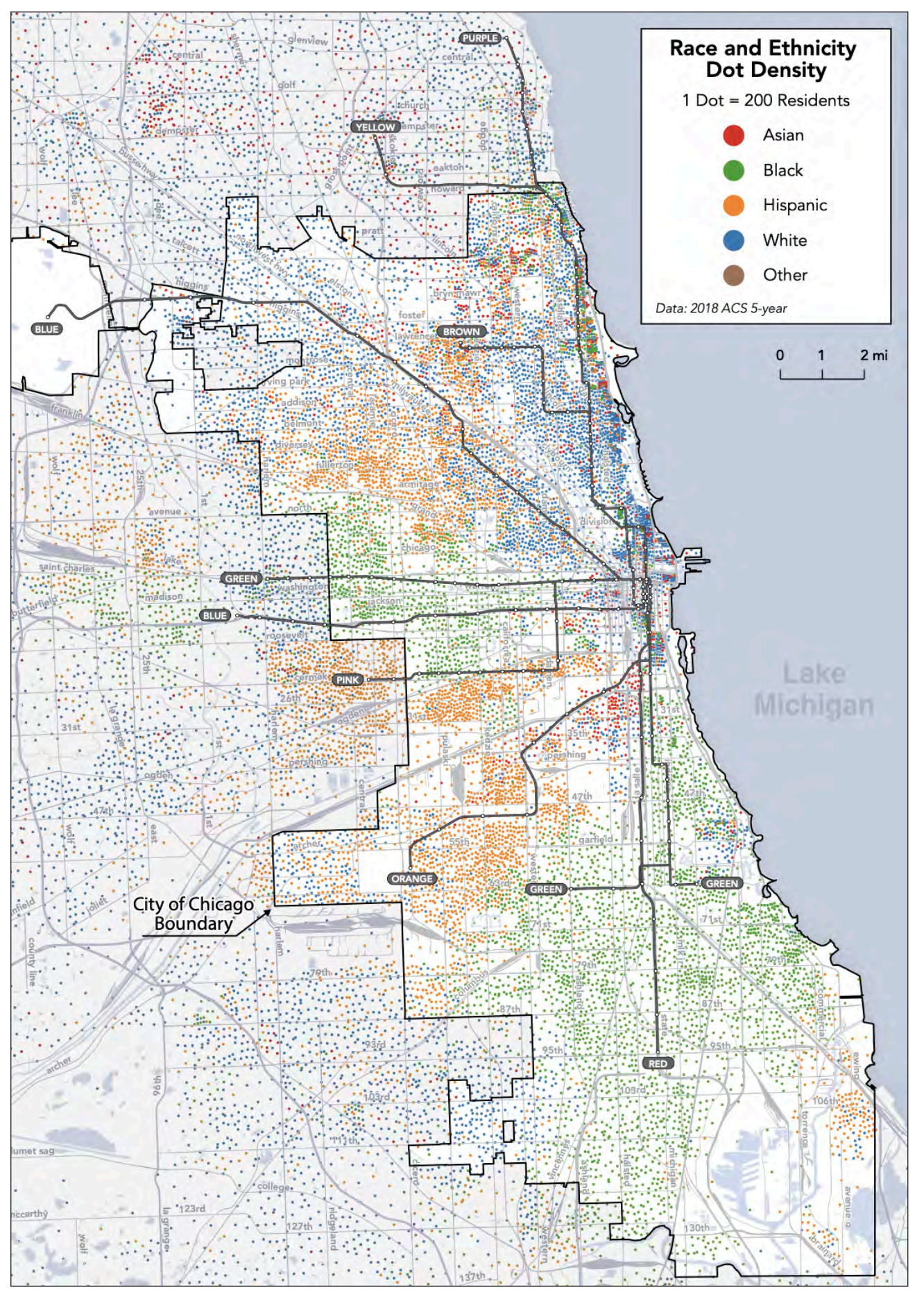
The racial geography of Chicago and its inner suburbs, from our report. White people (blue) live mostly around downtown or in the northern third of the city, where density is high and travel distances are short. The rest of the city features “pie slices” of mostly Hispanic/Latino (orange) or mostly Black (green) areas. Black people (green) dominate the remote South Side, where they tend to be furthest from jobs and opportunities.
The ridership-equity tradeoff is a consequence of the mathematically inevitable ridership-coverage tradeoff. A ridership-equity tradeoff arises wherever a ridership-maximizing network design would inadvertently disfavor disadvantaged groups, because those groups tend to live and travel in places where their needs are more expensive per person to serve. Chicago has this problem in a big way.
We have two key findings about this problem:
- Transit is doing a lot to help, and it can do more, but only by running some services that won’t be justifiable on purely ridership grounds.
- Transit by itself cannot be expected to heal the legacy of decades of racist land use and real estate policies. Only redevelopment that reduces the isolation of low-income and minority areas, and adds more jobs and educational opportunities near them, can do that.
This conflict between ridership and equity goals is important because CTA has long labored under an unrealistic requirement to pay 50% of its operating costs from the farebox. In 2010, funding shortfalls related to the recession led to service cuts that made it difficult to maintain equity.
A new vision of CTA will need to create a set of standards that will accurately reflect the real goals that motivate support for public transit. These will surely include an equity goal that will be a counterweight to a ridership goal, because it will justify service expansions in disadvantaged areas despite their lower ridership potential. The balance between those competing goals will need to be chosen, as a political decision. But as always when there are tradeoffs, expanded funding makes it easier to do both.
Chicago is a city with vast unrealized transit potential. Its grid geography allows for especially efficient network structure. It has many areas that could be redeveloped in more transit-oriented ways, especially to improve the balance between housing and activities on the South Side. But it is held back by two things: inadequate protection from traffic, which CTA and the City of Chicago are also working on, and inadequate frequency, which is purely a matter of operating funds.
I will be presenting to the Chicago Transit Board (which governs CTA) on this report later this year, and that will be the end of our contract. I don’t know if we’ll have any future role in CTA’s Bus Vision Project. Meanwhile, if you want to understand the CTA’s situation in more detail, please look at our report.
Why Pace Needs More Money
In the hearing, one Senator emphasized that he wanted to talk first about a vision of service, then about governance, and finally about funding. That suggests that rather than just talking about how to address the “fiscal cliff”, so as to keep things as they are, this would be a good time to present a positive vision of the level of service that could transform the relevance of public transit across the region.
That’s what we’re doing for Pace, the agency that provides bus services to almost all of the Chicago suburbs. Later this year we expect to release a report that will show both what Pace could do if its funding returns to 2019 levels, which is not much, but also what it could do with an expansion of funding. The public outreach process on those alternatives will happen toward the end of 2024.
There’s one finding I can share now, which won’t be a surprise to anyone who knows the network. Pace has never been resourced to keep up with development and population growth of the last 70 years.
If you look at the Pace network, you’ll see intensive local services focused on places that were already built out by the mid-20th century, mostly around the edges of Chicago and in the large, old satellite cities of Waukegan, Elgin, Joliet, and Aurora. An enormous area of newer suburban development has very little service, just a thin scattering of hourly bus routes and a few rush-hour express services.
The Pace network, with red denoting high frequency. (See legend.) Service is concentrated on the edges of Chicago and in the older satellite cities, leaving large developed areas, including much of DuPage County, unserved.
So when regional leaders think about how Pace should be resourced, they have to keep in mind that for decades Pace has been unable to grow as the region has grown.
That’s why the Pace project will show two alternatives for a substantial expansion of service, which is currently unfunded. We need to show people what it would mean to plan based on needs rather than just on constraints, and how that network could transform the possibilities of life in all of the suburban cities. These scenarios would bring service up to a level that comparable suburbs in many other states already have.
Will Consolidating the Agencies Help?
As I am a consultant who sees both CTA and Pace as clients, you should not expect me to disagree with their managements in public. So of course you should expect me to share their opposition to consolidating CTA, Pace and Metra into a giant agency.
But I really do think it would be a bad idea, for the same reasons that I’d oppose similar moves to create a single giant agency for the San Francisco Bay Area, which has also been proposed.
First, there aren’t that many economies of scale that arise from consolidating agencies as large as CTA and Pace. The resulting agency would be huge, and you should expect bureaucratic inertia to increase with hugeness. Two 50-bus agencies probably have a lot of duplicated administrative functions that you could consolidate in one 100-bus agency, but at the already-huge scale of CTA and Pace, further consolidation probably won’t eliminate much administration, because the job the new agency would have to do is so vast and diverse.
More importantly, dense core cities like Chicago and San Francisco have profoundly different transit needs and transit politics than their suburbs. Many US cities that are served by regionwide transit agencies have constant conflicts with their suburbs over how to get their needs met. Transit needs per capita are higher in dense cities, yet it is often difficult to get a regional transit authority, especially one dominated by suburban cities, to apportion to the core city more than its per capita share of service.
Dense cities are also where the most can be achieved through intimate coordination of transit planning, land use planning, and street planning. Since the latter two are controlled by city government, a lot can be achieved by urban transit agencies that are close to city government, if not part of it. San Francisco already has the model of an integrated transportation agency that handles both transit and street planning, allowing those functions to be harmonized. If you were going to merge CTA with something, it might make sense to merge it with Chicago Department of Transportation. Even now, CTA is ultimately answerable to the Mayor of Chicago, just as the SFMTA ultimately answers to the Mayor of San Francisco, so the Mayor is in the position to make transit, street planning, and land use planning work together.
In the hearing, Pace Executive Director Melinda Metzger argued that a combined Chicagoland public transit agency would also be bad for the outer suburbs, because Chicago’s interests would dominate. On balance, I think both Chicago and its suburbs should fear the creation of an agency so huge that it will be hard to bring its resources to bear on the actual problems of each community.
Waterford, Ireland: A Plan to Double Public Transport Service
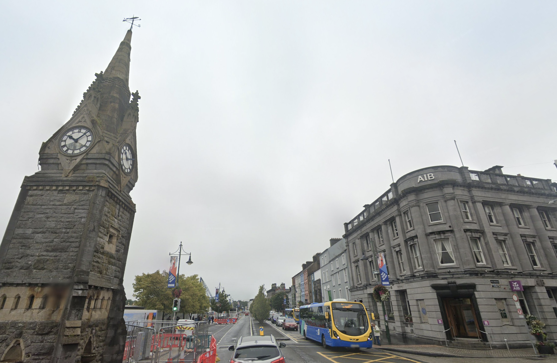
Waterford’s central bus interchange point. Source: Google Street View
One of the highlights of my career, and of our firm‘s recent history, has been a series of contracts for the National Transport Authority in the Republic of Ireland to redesign the bus networks of all the main cities, part of a larger national strategy called BusConnects. We started in Dublin in 2017, and have been progressing through the other four Irish cities: first Cork, then Galway and Limerick, and now finally Waterford, which has a metro area population of about 83,000. Dublin is now half-implemented, while the rest will be implemented over the next several years.
Our Draft New Network for Waterford was released Monday for public comment. It proposes to improve frequencies; replace one-way loops with two-way lines; add weekend service; and cover new areas. It would double the quantity of bus service in Waterford. I’m not sure we have ever before been asked to plan such a large expansion of service for relatively short-term implementation.
The level of policy clarity behind this expansion is remarkable. Ireland has “done the maths” about what must be done to achieve national goals for emissions and for social welfare, and has concluded that a big investment in urban buses is key to those goals. Ireland has a cost-effective rail improvement program, but it is still mostly a nation of roads. Its development pattern is dense compared to US cities but low-density compared to Continental Europe. (For example, most urban Irish housing is either rows of townhouses or semi-detached houses, what North Americans would call duplexes.) So the Irish government has concluded that only road-based public transport, developed at scale, can reach enough of the population to be relevant. They’ve also followed the logic through to land use planning, hiring us to write a guidebook, now published, on how to plan for useful, efficient bus services when laying out new suburbs and towns.
The planned service increases are massive. Dublin already had the most extensive network of the Irish cities, but even in Dublin NTA is increasing service by over 30%. The increases will be around 45% in Cork, Galway and Limerick, and now 100%, a doubling of service, in Waterford.
Why so much more? Waterford is starting with a fairly minimal network by Irish standards. Here’s the existing network. It’s five routes, with frequencies of 20-30 minutes. (Note that in a departure from our usual mapping style, we’re using linewidth rather than colour to indicate frequency, mostly because if we drew all these entangled loops in the same two colours you’d never be able to follow it.)

Considering that it is made up of only five routes, the Waterford network is quite complex. Much of the complexity is caused by one-way loops: two routes are entirely one-way loops, and the other three routes have sections of one-way loop or one-way split. The benefit of all these one-way services is that a large area can be covered without using much service, but it makes people’s trips time-consuming, and it makes the network harder to understand.
And here is the proposed network. Every route will offer two-way service. The wide lines stand for service every 15 minutes, 7-days-a-week. The narrow lines stand for service every 30 minutes, 7-days-a-week.
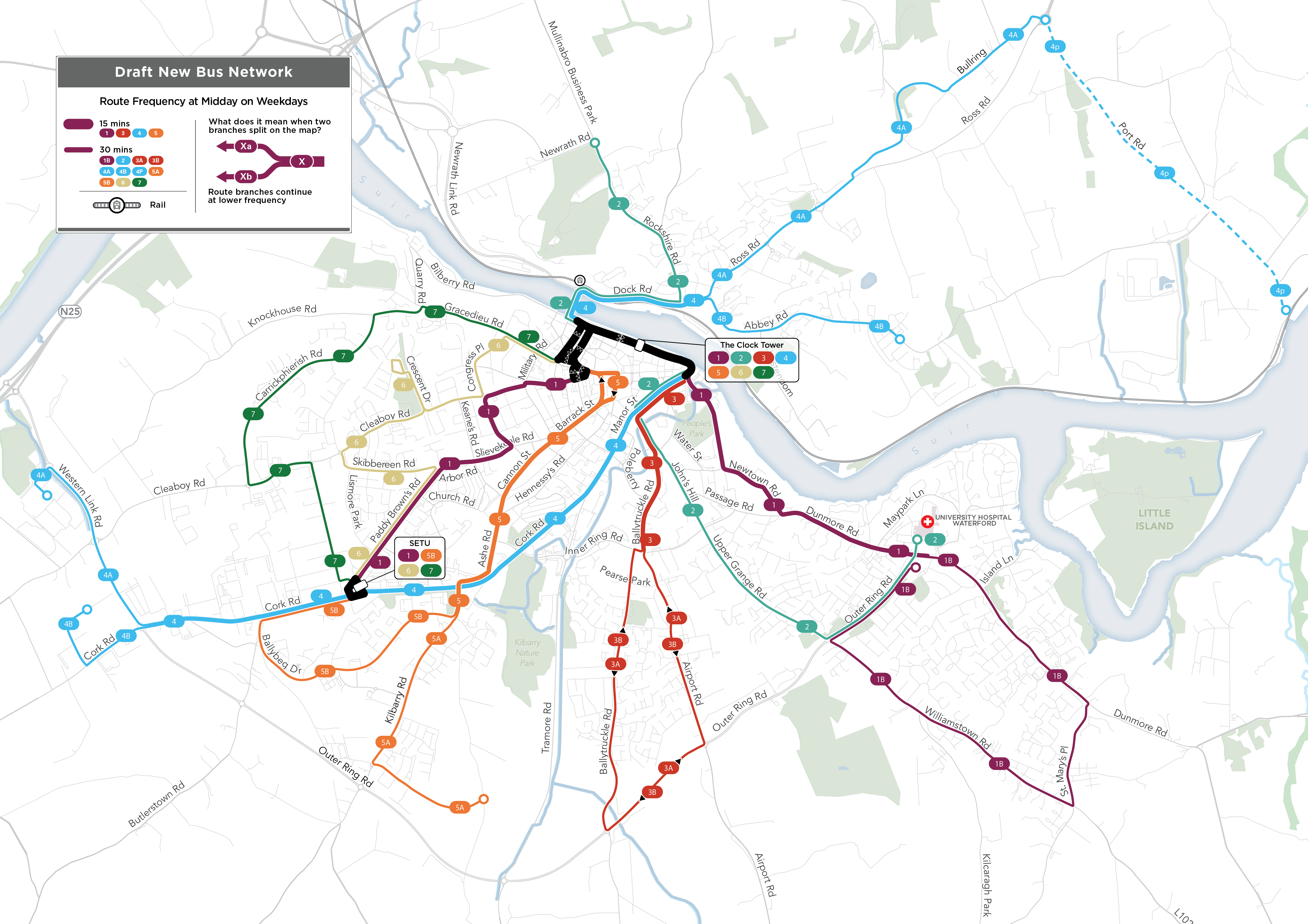
This design achieves several things:
- It’s radically simpler, because all routes are two way (with the exception of some short segments on one-way streets in the centre).
- It fits frequency better to demand. It offers 15-minute “turn up and go” frequency linking the biggest destinations, including the University (SETU), the city Centre, and the main hospital on the east side. Most of the really dense parts of Waterford are on these segments.
- It creates secondary focal points at the University (SETU) and hospital, offering direct service to these points from most of the areas surrounding them.
- It covers several recent new developments.
- Fewer routes end in the city centre. Instead, proposed Routes 1, 2, and 4 run through the centre and onward to the other side of the city. This reduces the need to interchange for many cross-city trips, and also makes better use of the limited space for terminating buses in the city centre.
As always, this is a draft! We know it will be improved by public feedback, which is already coming in. We look forward to the public conversation that starts now, and runs through 16 August.
Click here to explore the plan and express your view. You can find our entire report, with all of the details, here.
UK Election Night Thoughts
 Congratulations to everyone in the United Kingdom on a decisive election result, one that will unleash big changes in the public transport sector. The Labour party, which is on track for a large majority, promises to restore government’s right to manage public transport in the public interest, sweeping away Margaret Thatcher’s vision of public transport as a purely private and competitive business. Even before the election, the dam had already started to break, as the previous Conservative government had allowed Manchester and other big cities to reform Thatcher’s system.
Since 1985 the sort of public transport planning that governments normally do in wealthy countries has been illegal in the United Kingdom outside London and Northern Ireland. Privatization meant that private companies were free to run services whenever they liked, changing them on just a couple of months notice, and could also set their own fares. They kept the profits from high-ridership services but demanded government subsidies for low-ridership but critically needed coverage services. These companies were also too essential to fail: When Covid-19 gutted their fare revenue, government had to bail them out to keep essential services running.
A report by the Center for Human Rights and Global Justice describes the results of Thatcher’s grand experiment:
Privatization has not delivered a service that provides good value for money. Private operators’ primary goal is to earn a profit for shareholders, rather than provide the best possible service. Companies extract profits in the form of dividends, which otherwise could be reinvested in the system. They largely choose to run only profitable routes, resulting in cuts or forcing local transport authorities to step in at additional public cost. And far from taking buses off the government books, privatization has left the public on the hook for billions of pounds a year in subsidies.
Thatcher never imposed her experiment on London, because you simply can’t run a big city this way. At high densities, public transport service is intensely interdependent with other civic functions, especially land use planning and traffic management. Government needs confidence about what the buses and trains are going to do, so that it can provide certainty to developers, planners, and everyone else making decisions about the life and structure of the city. Voters also deserve to know that the service funded by their taxes is designed, operated, and priced in a way that reflects their goals and values.
In the new model, which the British call franchising, there will still be a role for the private operating companies. They’ll be able to compete for contracts to run portions of public transport networks, but those networks will be designed, managed, and marketed by governments. Fares will no longer be the basis of their profit. Instead, they’ll be paid a fair price to drive and maintain the services, enough to give them a small profit margin, and with various incentives and penalties for good and bad performance. Their success will depend on providing good service.
I’ve worked extensively in three countries that have made a similar transition fairly recently: Australia, New Zealand, and Ireland. In all three, I have led the planning of bus network designs for governments that were just starting to take firm control of public transport planning, usually while maintaining a role for the private sector. These transitions have been difficult, especially for the operating companies who must make cultural changes to match their new incentives, but they have made dramatic improvements in service possible. With this background, our firm hopes to find a role in the forthcoming tsunami of bus planning in the UK. In fact, we’d love to have a little office there. For now, I hope UK public transport advocates are enjoying their election night. Soon, the buses may even run late enough for you to get home from the party.
Toronto: Transport Futures Webinar Coming Up May 27
 On May 27 I’ll be doing a webinar focused on the greater Toronto area, sponsored by Transport Futures. I’ll talk about the new edition of my book and then take questions.
Details and registration here.
Look forward to seeing you there!
Video of My UCLA Event: Great Questions!
 Last month I did an event at the Institute of Transportation Studies at UCLA (the University of California at Los Angeles), hosted by Jacob Wasserman. It was fun, with many excellent questions that made me think. The video is on Youtube here.
The first 30 minutes are my presentation, and the fun part, the questions, starts at 33:40. Some highlights:
- 35:50 Jacob asks “What did Covid change?” (“Covid liberated the transit industry.”)
- 39:00 Jacob asks “When should we start caring about ridership again?”
- 43:00 Jacob asks “How can you design microtransit well? Where can it work?” (Triggers my hardware store analogy.)
- 48:20 Jacob asks about the importance of pricing of parking and driving, which leads into a riff lanes on bus lanes and “Bus Rapid Transit.”
- 51:30 Jacob asks “What tips would you give for writing well in planning?” (“Write to your grandmother.”)
- 58:10 Juan Matute, Deputy Director of the Institute, asks about opportunites to make transit easier to understand, especially for a new rider.
- 1:02:44 Audience question: “Have transit agencies had success influencing land use?” “You can’t expect the transit agencies to do this.” Here I make a reference to the Irish Planning Guide, which you can read about here.
- 1:06:10 Jacob asks “What is the role of consultants? Justify yourself!”
- 1:14:15 Josh Stevens of the California Planning and Development Report asks “How will autonomous vehicles affect transit?”
- 1:17:20 Audience question “What kinds of incrementalism are most important to get us to the point where we can make a big push (toward sustainabile mobility)” Thus prodded, I managed to end the event on a note of optimism.
Major US Public Transit Union Questions “Microtransit”
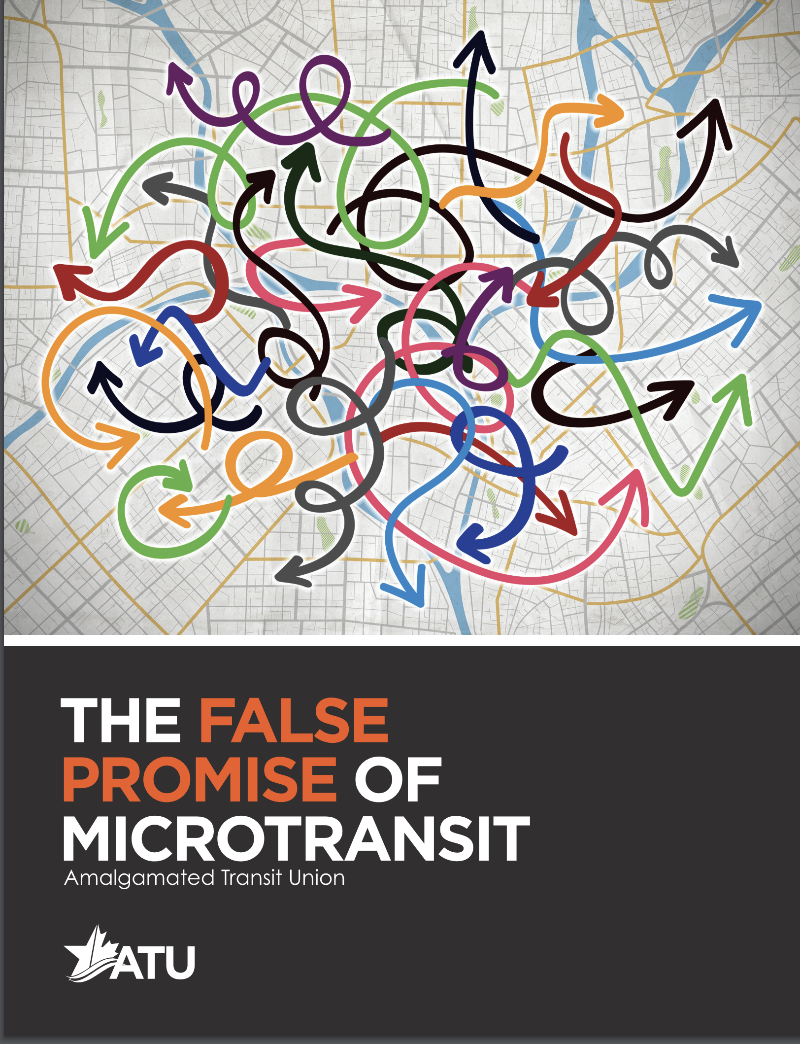 A dramatic report today from ATU, one of the major US transit unions, is called “The False Promise of Microtransit.” It has four big critiques of “microtransit,” also called on-demand transit or flexible transit.
Microtransit cannot efficiently scale to meet increased customer demand.
It has been shown to serve a younger, more affluent, and less diverse ridership than fixed route service.
Its environmental benefit is doubtful.
It encourages cost cutting through privatization and the degradation of transit jobs.
The first and third points are the same point. As I explained here, “microtransit” is so intrinsically inefficient that it can’t produce the environmental benefits that people associate with transit. Instead, its only coherent use is as a coverage tool, useful when an agency wants to take credit for providing lifeline access to an area whose layout and street pattern are inimical to fixed routes. The report has a striking quotation from Joshua Schank, who when he was at LA Metro was one of the biggest boosters of “microtransit”:
Admittedly, microtransit has so far proven to be more expensive on a per person basis than traditional transit. Even some of the lowest-performing bus routes in cities have lower subsidies per person than microtransit.” – Joshua Schank and Emma Huang, InfraStrategies
The ATU’s last point, that “microtransit” encourages cost cutting through privatization and the degradation of transit jobs”, is what you’d expect a union to say. US public transit agencies are tempted to contract with private operating companies to reduce labor costs, and some agencies, especially in the sunbelt, are entirely contract operated though still mostly with union labor. The ATU would obviously prefer to deal directly with government transit agencies, who are easier to influence than private companies. But setting apart a union’s self-interest, there is plenty of reason to be concerned with the “gig economy” effects, both on the larger society and on the transit customer experience. I believe that in the long run, we will get what we pay for in labor costs. I routinely get to experience both professional transit drivers and Uber/Lyft drivers, and the contrast is very obvious. Transit drivers are trained, and their compensation encourages them to make the work a career, not just a side hustle, so many are very experienced. All this is good for safety and customer service.