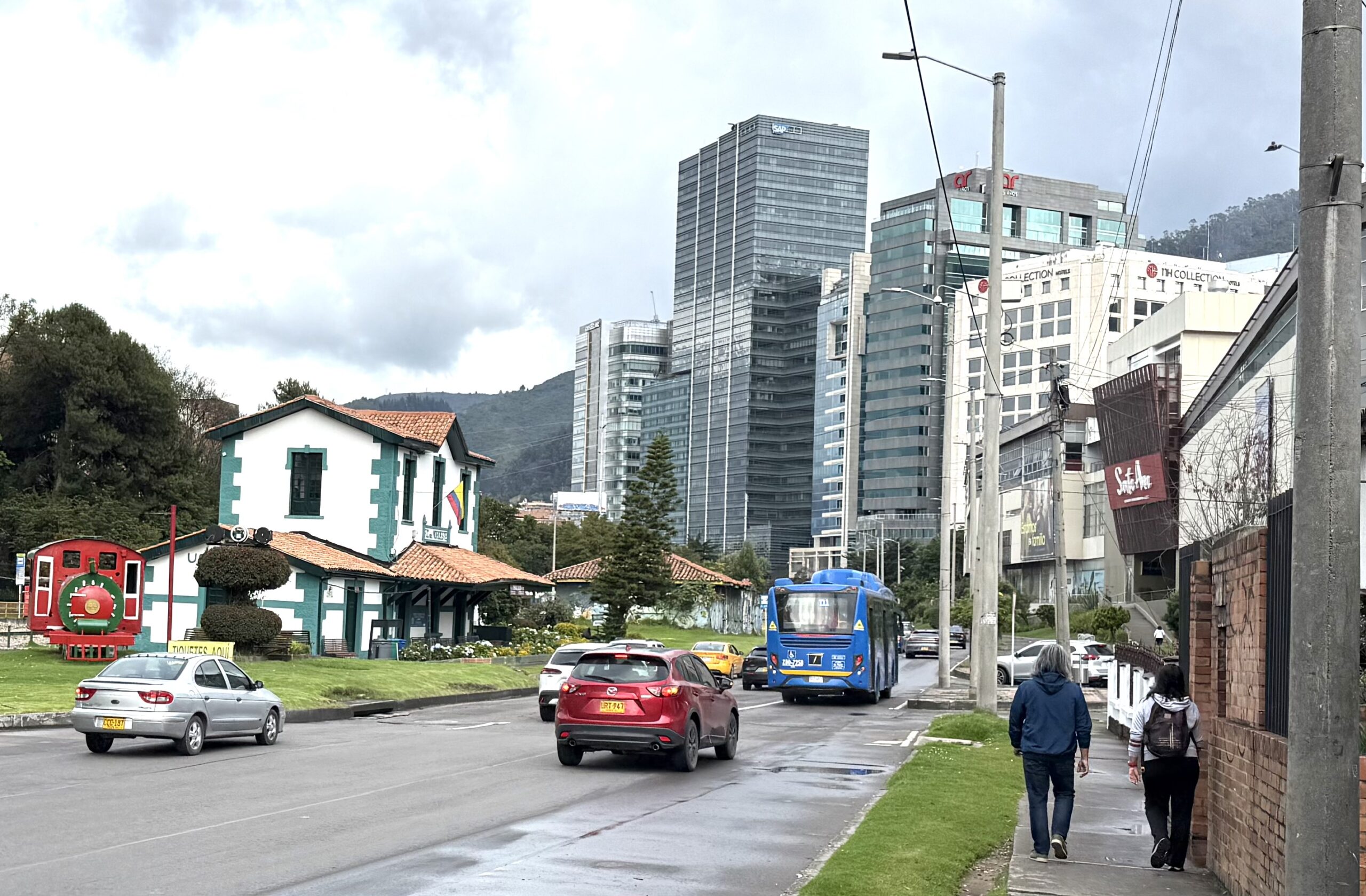
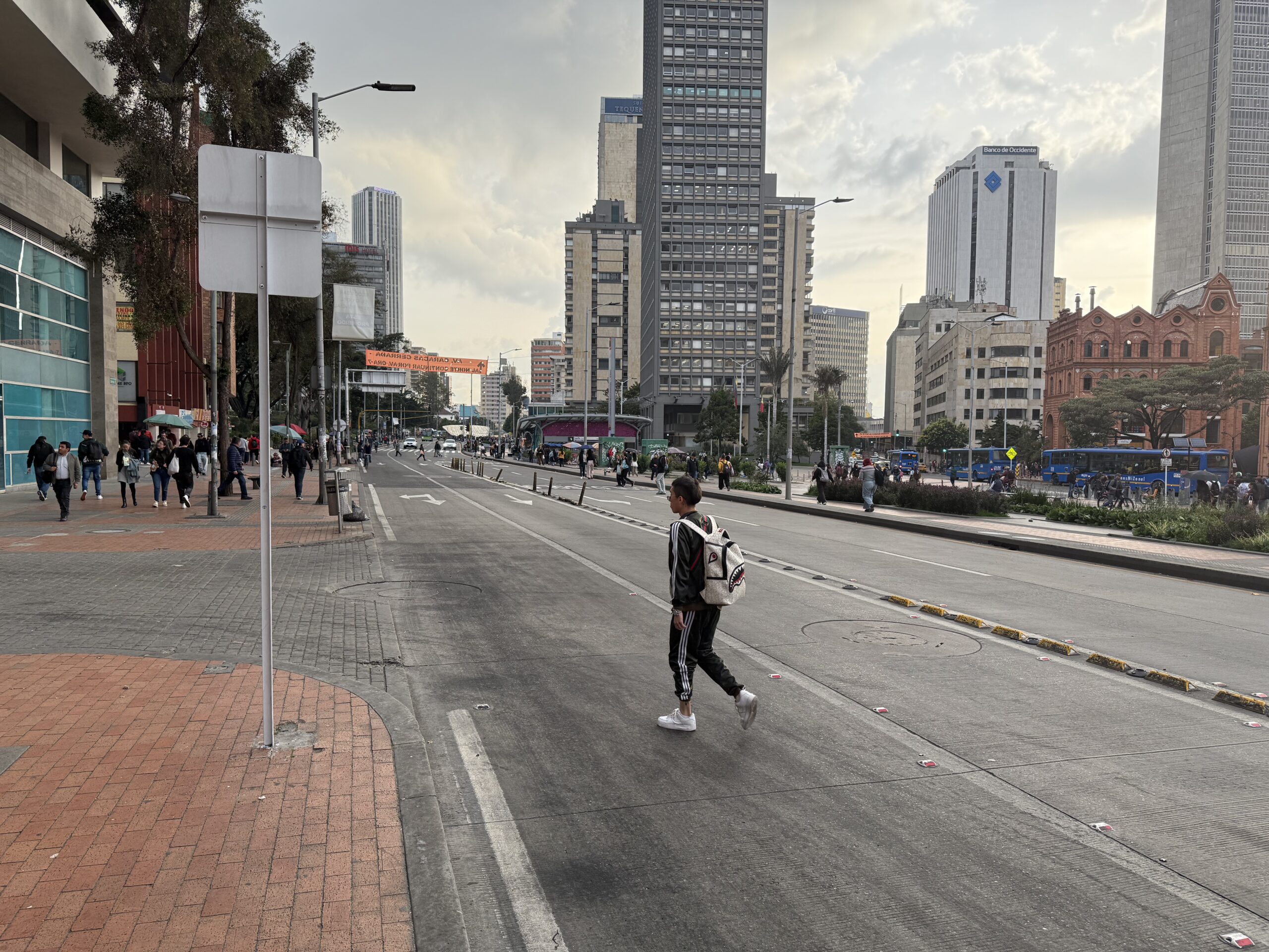
Poll: The 100 Most Influential Urbanists?

Planetizen is running a poll to create a list of 100 Most Influential Urbanists.  They last did this in 2017, when I was honored to be #57. They now have a new list of 200 nominees, partly based on public nominations, and want the public to rank them. I’m honored to be shortlisted again.

Personally, I’m not sure don’t how to vote in a survey that mixes figures from throughout (Western) history with people living today.  That mixing feels unfair both ways. People who lived longer ago have had more time for their influence to be felt. On the other hand, the living tend to be strongly biased toward other living people. Do those two unfairnesses cancel each other out? Probably not, except maybe among historians.  The bias toward the living is overwhelming. I’m not really the 57th most influential urbanist ever, because there have been countless influential people, in cultures all around the world, in all the millennia that there have been cities.  So I’d have had an easier time figuring out my vote if I hadn’t had to choose between people I know well and people who lived 2500 years ago. It’s like being asked if I prefer apples or Shakespeare.

Note, too, that the survey is asking how influential people were, not whether that influence was good or bad. The list contains several people whose net impact on urbanism has been negative in my view, including Robert Moses, Le Corbusier, and Elon Musk.  Will they be assessed purely on the magnitude of their influence and not its direction?  Perhaps historians can be called upon for such godlike moral neutrality, but I find myself struggling to give such figures fairly high marks for “influence,” since I would be contributing to their influence by ranking them.

But methodologically questionable as they always are, people love lists.  So whatever method you use to make these mysterious choices, I hope you have fun with it.  Vote here.

Akron: Welcome to Your New Network

New network in the core of Akron. Red = every 15 min, dark blue = every 30 min, light blue = every 60 min.

by Evan Landman

Akron METRO launched their reimagined bus network on June 4th!  Jarrett Walker + Associates assisted the agency in developing the new service plan over the past 2 years.

You can download the full map here.  On this page there’s also a side-by-side trip planner showing how any trip is made differently in the new network than the old one.

Despite dealing with the same operator shortage as all transit agencies have faced, METRO were able to implement nearly the entire service plan on Day 1, which included the following key elements:

  • 5 new high-frequency 15-minute corridors.
  • 3 new 30-minute routes in addition to 5 existing 30-min routes
  • New regional connections to greater Cleveland (which also implemented a JWA network redesign last year.)
  • Expanded weekend services, particularly on Sundays.

Old network for the same area. Red = every 15 minutes, purple = every 20 minutes, dark blue = every 30 minutes, light blue = every 60 min. Pale orange lines were less frequent than every hour.

Before the new network was implemented, METRO’s most frequent routes ran only every 20 minutes. The new network establishes frequent service to many key destinations and neighborhoods, including major hospitals, the University of Akron, and other important civic institutions. The Reimagined Network was designed to provide frequent and convenient service in busy places where many people need to travel to, while continuing to offer lifeline services in places where and for people for whom transit is essential.

With the new network, the median person in Summit County who lives near a bus route can access over 54% more jobs with a 45 minute transit trip; these outcomes are even larger for lower-income people and people of color, who are more likely to live in central Akron, where the new network’s most frequent routes are concentrated. This was achieved without a reduction in coverage – about 1% more people are now within a short walk to a transit than with the old network.

JWA congratulates METRO on the successful implementation of this plan. We’re proud to have assisted the agency in developing a new bus network that responds to the travel needs of today’s riders, and establishes the foundation for ridership growth in the future.


Los Angeles: A Major Expansion of Rail Transit Access

Los Angeles’s Regional Connector is open.  It’s a small piece of subway — less than two miles, with three stations, but it utterly transforms the rail network of Los Angeles, making trips across downtown much faster.  Here’s LA Metro’s quick diagram of the change:

It’s simple: In the network as it existed until this weeekend, light rail from north and east, called Line L, only came to the northeast edge of downtown, while the two lines from the south and west (Lines A and E) only came to the southwest edge. Traveling across the center thus required making two transfers, using the Line C & D Subway.  The Regional Connector rearranges these lines to that all services flow across downtown and out the far side. Much faster trips across downtown mean greater access to opportunity for many people across the city and beyond.

I’ve written before about the difficulty of getting regional focus on these core-city projects.  LA Metro did a good job with this one, starting by branding it the Regional Connector.  It may be in downtown Los Angeles but it’s not for downtown Los Angeles.  It’s for the entire region.

We’re Hiring!

Our firm has two openings for transit planning professionals in the US!

  • Transit GIS Analyst / Planner in Arlington, VA or Portland, OR.  Read about it and apply here.  This position closes July 16, 2023.
  • Senior Associate / Principal.  This one will be open until filled.  We are looking for someone who wants to join us at a senior level who would expand the range of our practice.  Read about it and apply here.

Read more about our firm here, and please spread the word!

Madison: Welcome to Your New Network

Today, the city buses in Madison, Wisconsin began doing something new, thanks to a network redesign project that our firm developed with our friends at Madison Metro.  Core parts of the network will run frequently all day for the first time.  More important, many travel times across the city will be much faster, because the plan deemphasizes four satellite transfer points that had been a big source of delay.

Here’s the city’s map of its new network.  (Click to enlarge, or see the original here.)  Lines A, B, C, and D are all frequent (every 15 minutes all day) out to the point where they branch.  (A1 and A2 refer to branches of Line A.)


Line A is designed to match the path of the forthcoming Bus Rapid Transit project, while Line B is the next BRT project after that one.

How much better is this?  Here was the old network, in our style where red lines indicate high frequency:

The old network was all infrequent, except for the University of Wisconsin’s shuttle routes 80 and 84. The new network, by contrast, has four frequent lines (A-D) covering all of the densest inner city and radiating outward in several directions. But the oddest feature of the old network was the four satellite transfer points located just a few miles out from the city center. Most of the outlying area was on feeder routes, requiring a connection at one of these points just to reach downtown or the University of Wisconsin. These points did make it easy for people to travel locally within their area, but on balance, they did more to obstruct trips than they did to enable them.

Our plan largely deemphasized these facilities.  Now, most of the city is on a direct route to the center, with much faster travel times.  Satellite hubs can be valuable to foster a network that serves trips in many directions, but the South, East, and North Transfer points were too close to the center to serve as good hubs, and none of them had significant destinations at them that could benefit from the converging service.  East Towne Mall, further out to the northeast, has a better future as a hub, both because it’s far enough from downtown and because it is a destination in its own right.   The same may be true of West Towne Mall on the west side (where the new network’s A, H, and J routes converge.) However, even if those hubs emerge, the main radial services (Line A) will flow through them, not be interrupted by them.

We had a great time working in Madison.  The city has many engaged advocates and stakeholders who provided great feedback, and many elected officials gave the project a lot of time and attention.  We hope the new network will help people in Madison go to places they’d never have gone to before, to do things they might never have done.

The Old, Old Idea of High-Tech Cars

Dense cities don’t have room for everyone’s car.  If too many people use cars, they take up all the available space and still get in each other’s way, which is what congestion is.

This was all obvious, and much discussed, when cars first appeared on the scene.  So the prospect of making the car the dominant tool of urban transportation — as opposed to, say, something you might rent to make a trip into the countryside — should have been easy to recognize as a scam.

Historian Peter Norton’s first book, Fighting Trafficchronicles how this scam took over the United States to create the way of life that most Americans now see as normal.  Exploiting understandable frustrations with the for-profit transit of the time, the nascent car and petroleum industries “partnered” with government to build a sense of inevitability around car-based travel.   This campaign had all of the disastrous results that were in fact predicted at the time — road carnage, pollution, and congestion.

Why did people fall for it?  In part, because “innovation” was going to fix those problems soon, leading us to a new utopia where we could take our cars wherever we wanted, safely, cleanly, and without delay. Norton’s new book, Autonorama: The Illusory Promise of High-Tech Driving, fills in more detail on this critical element of the scam, and shows how it operates in the driverless car narratives of today.

Obviously, actual technological improvements to make driving safer are to be welcomed.  The danger lies in the impossible visions of the congestion-free autonomous-car-dependent city, which is then cited as a reason not to invest in proven methods of urban transportation, such as public transit.  The claim that autonomous driving can fix congestion is no longer as loudly proclaimed as it was a few years ago, but it’s still out there.  The only basis of this claim is that because a computer’s reaction time is faster than a human’s,  autonomous cars could drive closer together at high speed, taking less space.  This, of course, is a minor improvement compared to the countervailing force of induced demand: Eliminating the hassle of driving will cause a lot more driving.  We have seen this before.

In the century-long history of high-tech car boosterism, Norton detects cycles of peak hype roughly 25-30 years long, peaking in the 1930s, 1960s, 1990s, and now.  At the peak of each cycle, a burst of technical innovation, fused with intense funding and public relations efforts, seems to bring the dazzling future almost within reach.  When the vision fails to deliver, there’s an inevitable pause of 20 years or so.  Memories fade, and perhaps more important, a generation reaches their 20s who don’t remember the last cycle, and whose sincerity and energy give the effort new life.

Norton calls the newest of these cycles Autonorama (a portmanteau of Futurama and autonomous), but his description of it captures what all four cycles have had in common:

Autonorama is the place where old-fashioned car-dependency is lent new credibility through the application of a fresh gloss of high-tech novelty, where simple possibilities are neglected not because of their inferiority but because of their simplicity, and where implausible promises of perfection divert attention from practical possibilities of actual improvement.  In Autonorama transportation research looks like public relations (and vice versa), theoretically possible performance is equated with actual performance, and technology is less a human means to human-chosen ends than a mysteriously willful entity that inevitably delivers ever-better solutions …

None of this is a secret, really. If you read business journalism you can find corporate gurus explaining their methods with pride:

In 1929 [Charles] Kettering distilled his advice into an article, written for Nation’s Business, called “Keep the Consumer Dissatisfied.”  “If everywhere were satisfied,” he explained, “no one would buy the new thing.”  To Kettering, transport sufficiency was a threat to motordom’s future.  He advocated perpetual insufficiency, propelled by an ever-receding promise of future perfection.

In the book’s first four chapters, Norton explores the four cycles that we’ve been through so far, ending with the current moment of autonomous-car boosterism.  But the most powerful chapter is the fifth, “Data Don’t Drive,” which will train you to recoil when you hear the term data-driven.  Norton explores how invocations of data as the ultimate authority invite us to surrender to interests and goals that may not be ours.

Part of the problem is that data is a valuable commodity.  “Data is the new oil,” as they say.  Norton even turns up a McKinsey report arguing that the real importance of driverless cars is that it will allow us to spend more time interacting with screens, generating data about ourselves that can be used to target and manipulate us.

But the real issue is that data is a tool, not a goal, and only humans can specify the goal.  As Norton puts it, “data can tell people which efforts are serving their goals and which are not, but the goals must be chosen first, and by people.”  In my own career, I’ve seen countless studies that sought to overwhelm the reader with data and analysis, not to illuminate the real choices (as our firm‘s work does) but to make them surrender to the goals (sometimes not clearly stated) of the proponents.  Traffic engineering is full of this kind of talk (“the data show that we need to widen the road”) and you’ll sometimes hear it in transit planning too.

I heartily recommend this book.  It will remind you, once again, of why historians are as urgently needed as scientists in our brave new technological future.


La Sombrita: A Sculpture About the Rules

Credit: Streetsblog Los Angeles

Two weeks ago the Los Angeles Department of Transportation unveiled La Sombrita, a privately-funded demonstration project that makes a tiny improvement to the situation of people waiting at unsheltered bus stops in Los Angeles.  La Sombrita (“the little shade”) is a small panel attached to pole that casts a very small amount of shade, and that lights up at night. That’s it.  That’s all it does.

The blowback among bus riders and transit advocates was intense, and the whole thing ended up in the New York Times.

La Sombrita looks pretty sad, but that’s the point.  If you accept the wildly unjust apportionment of space on the Los Angeles street, and you obey all of the rules and regulations around building things in the public right of way, you get this.  To a degree, making that point is what La Sombrita is for.

Kriston Capps in Bloomberg has the best summary I’ve seen of this teachable moment.  Read the whole thing.  The key passage comes from a conversation with Chelina Odbert, who heads the design collective behind La Sombrita.

Fabricating a prototype that actually fits within all the applicable constraints can actually help to highlight the problem at hand. The way Odbert describes it, the iterative design process itself functions as a form of criticism. She gives an example: After the Los Angeles City Council voted to legalize street vending in 2018, food vendors ran into a problem. Their carts couldn’t pass inspections meant for brick-and-mortar restaurants. As an exercise, Kounkuey designed (but did not fabricate) a cart that would meet LA’s high standards. With its mandatory hand-washing station, fire extinguisher and 20 cubic feet of dry storage, this street-legal vending cart design would stretch 12 feet and weigh 700 pounds.

Obviously, an SUV-sized cart would be no use to tamale vendors, one of whom designed his own prototype (which was eventually approved). But by engaging with this farcical process, Kounkuey helped illustrate its flaws. With the absurd rendering in hand, Odbert says, the designers were able to lobby the county for changes to the health code.

La Sombrita deserves praise, especially as a privately-funded initiative, as a demonstration of how ridiculous the rules governing bus stops are.  If you want to improve a bus stop fast without requiring complicated permits or violating any laws, La Sombrita is what you can do.  Don’t like it?  Then it’s time to change those rules, and now you have a public sculpture to make your point.

Lyft: The End of Shared Rides

I frequently travel in places and situations where public transit isn’t useful, especially in the transit-poor United States.  So I’ve been a frequent user of Lyft, a shared-ride competitor of Uber.  It was an easy choice.  Although the Lyft and Uber products are the same — often provided by the same cars and drivers — Lyft’s founders were credibly supportive of public transit, so their basic branding, “Uber with a conscience” or “Uber but nice” was pretty much directed at customers like me, although I had no illusions about where the ultimate profit motive would lead them.

One virtuous thing that Lyft attempted was shared rides.  For a lower fare, you could get a ride that would also pick up someone else along the way.  This would reduce VMT and provide lower fares for fare sensitive folks, though still much higher than public transit fares.

I used this service once.  On a departure from the airport, it paired my trip with one in a substantially different direction.  The other trip was to a point further from the airport than my destination, and yet it served that trip first.  I ended up with a travel time about twice what my direct travel time would have been, and much more than the app had estimated.  I never used this option again.  My impression was that they were overselling the product in contexts where it wasn’t appropriate, and they were offering the same discount to the person dropped off first — whose trip is exactly what it would have been if traveling alone — as to the person whose trip was being made much longer.

Drivers apparently hated it too, judging from many of the comments on this Reddit thread.  They didn’t pay drivers enough to deal with the hassles, including customers not understanding the rules and poor relations between strangers sharing the car.  Now, Lyft has abandoned shared rides, although Uber appears to be planning to expand them.

But shared-ride products are still needed, especially when demand appears all at once in high volume.  A common scenario: A plane lands at a small-city airport at midnight.  A line of 100 people ends up at the taxi stand.  Taxis are programmed to carry single parties.  In this situation I will usually poll the people around me in line to see if anyone shares my destination, which may be likely if it’s a downtown hotel.  But we must then present ourselves to the taxi driver as a single party, or they will charge us more.  It’s remarkable that in this particular case, late night airport to downtown, there isn’t a workable solution.  Because while it can be a pain to have another person in the car, it would be even better to get to the hotel at 1 am instead of 3 am, and a small town with 17 taxis and a few Lyft cars is not going to serve us all very quickly if it insists on serving us all separately.

Of course, there should really be a bus to downtown meeting this late-night airplane, but planes are late a lot, and transit agencies can’t devote a bus to meeting an unpredictable arrival time.

If you are not a traveling businessperson like me, this may all sound very “first world problems” to you, but there is a lot of VMT in carrying a bunch of people from an airport to the same distant cluster of hotels at the same time, all in separate cars.  I’m disappointed Lyft couldn’t focus this product on that problem, grouping people only when their destinations were very close together, and thus creating a product that both customers and drivers could be believe in.

Update on Human Transit, Revised Edition

First draft of the cover. Thoughts?

Whew! Last night I delivered the manuscript to Island Press for a Revised Edition of Human Transit.  It’s been a bigger project than I expected.  I started out thinking that I could just add some material and the rest would stand as it was, but as I got into it I saw more things that I could improve, and now it’s pretty substantially revised.  There’s nothing I would retract in the old version, of course.  Certainly, the geometry isn’t out of date.  But there are things I can say better now, so I do.

There are new chapters on planning for diversity, planning for access to opportunity, and network redesign, as well as new material on flexible transit (a.k.a demand-responsive transit or “microtransit”) and on Bus Rapid Transit.  And I’ve added some more pointed commentary about the challenge of sorting through technological claims that have been amplified by venture capital.

It should come out in February 2024.

Meanwhile, here’s the rough draft of the cover, based on a sketch by the architect Eric Orozco.  We were trying to capture the way that an abstract transit line turns into access which turns into human joy and possibility.  Let me know what you think.

And yes, now that that’s done I should be blogging more.

Galway, Ireland: A Proposed Bus Network

We’ve been honored to work with the National Transport Authority of Ireland on proposed network redesigns for all of the Irish Republic’s major cities: Dublin back in the late 2010s, Cork over the last two years, and now Galway and Limerick. (Waterford is coming next year.) The Galway plan is out now.  You can explore it here.  You can view the new network map here and compare it to our drawing of the current one, in the same style which is here.

Some key facts:

  • 38% more jobs reachable within 30 minutes on weekdays (daytime) for the average resident
    • And +43% on Saturdays, +54% on Sundays
  • one-third of residents would be within a 5 minute walk of a frequent route, which is nearly double the current number
  • nearly one-half of jobs would be within a 5 minute walk of a frequent route, up from 30% on the existing network
    • and of course many people are willing to walk more than 5 minutes to reach high frequency service
  • More residents and jobs covered by service of any frequency
  • More evening and weekend service
  • A new 24-hour route (Route 9) across the city
  • About 50% more service quantity overall in the bus network.

(US readers are welcome to salivate at the prospect of a transit network expanding by 50% in one go, in a city of only 84,000 people, but that’s where Ireland is in terms of its commitment to public transport.  It helps that public transport is funded directly out of the national budget, rather than through separate agencies each managing their own finances.)

We loved the challenges of working in Galway.  As in all Irish cities, the geography is hard — not just the narrow streets of the historic core, but the lack of any kind of grid pattern that would suggest an obvious pattern of transit lines.  Every bit of the city required a great deal of thought.

We look forward to feedback!